
![Plan général du Fort Septentrional du Detour des Anglois, tel qu'il est présentement : [Louisiana]](https://cybercemetery.unt.edu/archive/oilspill/20121207201502im_/http://www.loc.gov/collections/static/louisiana-european-explorations-and-the-louisiana-purchase/images/lh000949.jpg)
![[Rough sketch of the Rich Mountain battle area extending from Beverly, W. Va. to Clarksburg].](https://cybercemetery.unt.edu/archive/oilspill/20121207201502im_/http://www.loc.gov/collections/static/hotchkiss-maps/images/cwh00078.jpg)


![[December 23, 1944], HQ Twelfth Army Group situation map.](https://cybercemetery.unt.edu/archive/oilspill/20121207201502im_/http://www.loc.gov/collections/static/world-war-II-maps-military-situation-maps-from-1944-to-1945/images/ict21202.jpg)
![[December 25, 1944], HQ Twelfth Army Group situation map.](https://cybercemetery.unt.edu/archive/oilspill/20121207201502im_/http://www.loc.gov/collections/static/world-war-II-maps-military-situation-maps-from-1944-to-1945/images/ict21204.jpg)
Results
-

Map of the Danville, Olney & Ohio River Railroad and its connections.
Scale 1:1,267,200.
Contributor: G.W. & C.B. Colton & Co Site: American Memory-cultural - Main Catalog Original Format: Map Date: 1881 View catalog record -

Map of central Montana, the Montana Railroad, September 1, 1899.
Blueprint.
Contributor: Polley, J. F. Site: American Memory-cultural - Main Catalog Original Format: Map Date: 1899-09-01 View catalog record -

Map of the Bellefontaine and Indiana Railroad and connecting lines.
Scale ca. 1:1,500,000.
Contributor: Roberts, W. Milnor Site: American Memory-cultural - Main Catalog Original Format: Map Date: 1852 View catalog record -

Map of railways in New England and part of New York; engraved by D. C. Hitchcock for the Pathfinder Railway Guide.
Scale [ca. 1:2,700,000].
Contributor: Snow & Wilder Site: American Memory-cultural - Main Catalog Original Format: Map Date: 1847 View catalog record -

Map showing the Atchison, Topeka & Santa Fé Rail Road and its auxiliary roads in the state of Kansas.
Scale 1:1,140,000.
Contributor: G.W. & C.B. Colton & Co Site: American Memory-cultural - Main Catalog Original Format: Map Date: 1886 View catalog record -

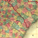
Map showing the line of the Virginia, Tennessee, & Georgia Air Line composed of the Shenandoah Valley R.R., Norfolk & Western R.R. and the East ...
Scale 1:3,800,000.
Contributor: G.W. & C.B. Colton & Co Site: American Memory-cultural - Main Catalog Original Format: Map Date: 1881 View catalog record -

Centennial American Republic and railroad map of the United States and of the Dominion of Canada. Compiled from the latest official sources.
Scale ca. 1:4,400,000.
Contributor: Watson, Gaylord Site: American Memory-cultural - Main Catalog Original Format: Map Date: 1875 View catalog record -

W. Alvin Lloyd's southern rail-road map, 1863
Includes inset maps: Rail-Roads of Texas and Map of Charleston Harbor.
Contributor: Lloyd, W. Alvin Site: American Memory-cultural Original Format: Map Date: 1863 -

Map showing the route of the Continental Railway and its connecting lines.
Scale 1:2,217,600.
Contributor: G.W. & C.B. Colton & Co Site: American Memory-cultural - Main Catalog Original Format: Map Date: 1873 View catalog record -

Railroad map of Indiana.
Scale ca. 1:1,000,000.
Contributor: Morris, Thomas A. Site: American Memory-cultural - Main Catalog Original Format: Map Date: 1852 View catalog record -

Map showing the location of the Charleston & Savannah R.R. May, 1856.
Scale 1:180,000.
Contributor: Walker, Evans & Co Site: American Memory-cultural - Main Catalog Original Format: Map Date: 1856 View catalog record -

Bridgman's new rail road & township map of New York from the latest official & other authentic sources adapted for use in institutions of learning, ...
Scale 1:320,000.
Contributor: Bridgman, E. C. Site: American Memory-cultural - Main Catalog Original Format: Map Date: 1896 View catalog record -

Map of the Rio Grande and Pecos Railway showing its connections with the Texas Mexican, Texas Mexican Short Line, Mexican National, Texas & St. Louis, ...
Scale not given.
Contributor: Rio Grande and Pecos Railway Co Site: American Memory-cultural - Main Catalog Original Format: Map Date: 1882 View catalog record -

A new sectional map of the state of Kansas showing the route of the Union Pacific Railway--E. D. to Denver City. Col. and complete system ...
Scale 1:253,440.
Contributor: Du Bois, Charles Site: American Memory-cultural - Main Catalog Original Format: Map Date: 1867 View catalog record -

Map of the state of Nebraska showing the lands of the Burlington & Missouri Riv. R.R. Co. in Nebraska.
Scale ca. 1:1,000,000.
Contributor: G.W. & C.B. Colton & Co Site: American Memory-cultural - Main Catalog Original Format: Map Date: 1876 View catalog record -

Map of the territory of the United States from the Mississippi River to the Pacific Ocean; ordered by Jeff'n Davis, Secretary of War to accompany ...
Scale 1:3,000,000.
Contributor: Warren, G. K. Site: American Memory-cultural - Main Catalog Original Format: Map Date: 1858 View catalog record -

Dedicated to the city of Philadelphia through the directors of the Pennsylvania Railroad Company; plan no. 2. exhibits the streets with the present railroads removed; ...
Scale ca. 1:40,000.
Contributor: Hoxsie, S. K. Site: American Memory-cultural - Main Catalog Original Format: Map Date: 1858 View catalog record -

Cuba.
Also shows roads and railroads.
Contributor: United States. Central Intelligence Agency Site: American Memory-cultural - Main Catalog Original Format: Map Date: 1964 View catalog record -

Map showing the line of the Milwaukee & St. Paul Railroad and its western and north western connections.
Scale 1:1,267,200.
Contributor: G.W. & C.B. Colton & Co Site: American Memory-cultural - Main Catalog Original Format: Map Date: 1865 View catalog record -

From San Francisco Bay to the Plains of Los Angeles : from explorations and surveys /
Scale 1:760,320.
Contributor: Custer, H. Site: American Memory-cultural - Main Catalog Original Format: Map Date: 1859 View catalog record