


![[December 18, 1944], HQ Twelfth Army Group situation map.](https://cybercemetery.unt.edu/archive/oilspill/20121207195955im_/http://www.loc.gov/collections/static/world-war-II-maps-military-situation-maps-from-1944-to-1945/images/ict21197.jpg)

![[Map of parts of Caroline, Hanover, and Henrico counties, Va. west of the Mattaponi River and the Richmond, Fredericksburg, and Potomac Railroad].](https://cybercemetery.unt.edu/archive/oilspill/20121207195955im_/http://www.loc.gov/collections/static/hotchkiss-maps/images/cwh00025.jpg)

![[January 1, 1945], HQ Twelfth Army Group situation map.](https://cybercemetery.unt.edu/archive/oilspill/20121207195955im_/http://www.loc.gov/collections/static/world-war-II-maps-military-situation-maps-from-1944-to-1945/images/ict21211.jpg)


![[Base map of Pennsylvania].](https://cybercemetery.unt.edu/archive/oilspill/20121207195955im_/http://www.loc.gov/collections/static/hotchkiss-maps/images/cwh00207.jpg)
Results
-

Birds eye view of Franklin, Southampton Co., Virginia 1907.
Perspective map not drawn to scale.
Contributor: Fowler, T. M. Site: American Memory-cultural - Main Catalog Original Format: Map Date: 1907 View catalog record -

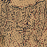
Sussex, Southampton counties, Virginia /
Pen-and-ink and pencil on 2 sheets pasted together, mounted on cloth.
Contributor: Hotchkiss, Jedediah Site: American Memory-cultural - Main Catalog Original Format: Map Date: 1867 View catalog record -

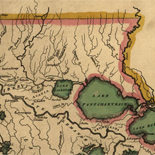
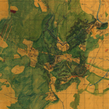
Position of Richmond, Va. /
Relief shown by hachures and pictorially.
Contributor: Abbot, Henry L. Site: American Memory-cultural - Main Catalog Original Format: Map Date: 1862 View catalog record -

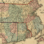
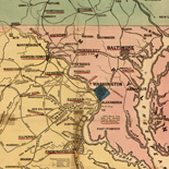
Part of map of portions of the mility. dep'ts of Washington, Pennsylvania, Annapolis, and north eastern Virginia /
Relief shown by shading.
Contributor: United States. Topographical Bureau Site: American Memory-cultural - Main Catalog Original Format: Map Date: 1862 View catalog record -

Sunday, May 3rd : [Map of the battle of Chancellorsville]
Relief shown by hachures.
Site: American Memory-cultural - Main Catalog Original Format: Map Date: 1863 View catalog record -

Campagne en Virginie du Major Général M'is de LaFayette : ou se trouvent les camps et marches, ainsy que ceux du Lieutenant Général Lord Cornwallis ...
Covers central Virginia from Orange County in the north to Isle of Wight County in the south, and west to Cumberland County.
Contributor: Capitaine du Chesnoy, Michel Site: American Memory-cultural - Main Catalog Original Format: Map Date: 1781 View catalog record -

[Plat of survey for John Lindsey of 223 acres in Frederick County, Va.].
Scale ca. 1:18,097.
Contributor: Washington, George Site: American Memory-cultural - Main Catalog Original Format: Map View catalog record -

Map of Virginia : showing the distribution of its slave population from the census of 1860 /
"Sold for the benefit of the sick and wounded of the U.S. Army."
Contributor: Graham, H. S. Site: American Memory-cultural - Main Catalog Original Format: Map Date: 1861 View catalog record -

Map showing the locations of the battlefields of Fredericksburg, Hamilton's Crossing, Chancellorsville, Salem Church, Wilderness, [and] Spotsylvania, and also showing the boundaries of the battlefield ...
Scale ca. 1:90,000.
Contributor: Kishpaugh, Robert A. Site: American Memory-cultural - Main Catalog Original Format: Map Date: 1906 View catalog record -

Route from Manassas to Centreville, August 28th to 31st.
Legend at the bottom of the map gives the marking for the route of the headquarters train of General Heintzelman under whom Sneden served.
Contributor: Sneden, Robert Knox Site: American Memory-cultural Original Format: Map Date: 1861 -

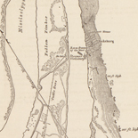
[Map of Drewry's Bluff, Chesterfield Co., Va.]
"Chief Engineer's Office, D.N.V., Maj. Gen. Jeremy Francis Gilmer, Chief Engineer."--printed on map.
Site: American Memory-cultural Original Format: Map Date: 1864 -

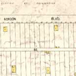
Perspective map of Buena Vista, Va. 1891.
Perspective map not drawn to scale.
Contributor: American Publishing Co. (Milwaukee, Wis.) Site: American Memory-cultural - Main Catalog Original Format: Map Date: 1891 View catalog record -

Plan of the battle of Chantilly, Virginia. Fought Septr. 1st 1862, 5 to 10 PM.
Color coding indicates the location of Union and Confederate forces.
Contributor: Sneden, Robert Knox Site: American Memory-cultural Original Format: Map Date: 1862 -

Official plan of the siege of Yorktown, Va. : conducted by the Army of the Potomac under command of Maj. Gen. George B. McClellan U.S.A., ...
Contains a list of the "proposed armament of batteries."
Contributor: Abbot, Henry L. Site: American Memory-cultural Original Format: Map Date: 1862 -

The field of Fredericksburg : showing the positions of the troops on the morning of December 13, 1862 /
Annotated in red and blue to show Union and Confederate positions.
Contributor: Geo. W. Stadly & Co Site: American Memory-cultural Original Format: Map Date: 1898-01-01 -

[Map of the northern part of Virginia and West Virginia, between the Blue Ridge and the Alleghany Front, south of the Potomac River and north ...
Relief shown by hachures and shading.
Site: American Memory-cultural - Main Catalog Original Format: Map View catalog record -

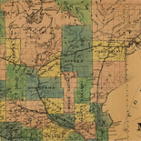
Map of Botetourt County.
"Chief Engineer's Office D.N.V. Maj. Gen. J.F. Gilmer, Chief Engineer."--map.
Site: American Memory-cultural Original Format: Map Date: 1864 -

Army map of the seat of war in Virginia : showing the battle fields, fortifications etc. on & near the Potomac River /
"Entered according to act of Congress, in the year 1861, by John Disturnell, in the Clerk's Office of the District Court of the United States for the Southern District of New York."
Contributor: Bruff, Joseph Goldsborough Site: American Memory-cultural Original Format: Map Date: 1862 -

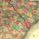
Map of the seat of war in Virginia.
Covers southern Virginia and northern North Carolina extending from Richmond, Va. south to Raleigh, N.C.
Site: American Memory-cultural - Main Catalog Original Format: Map Date: 1865 View catalog record -

Matomkin Inlet, Virginia /
Depths shown by soundings.
Contributor: United States Coast Survey Site: American Memory-cultural - Main Catalog Original Format: Map Date: 1862 View catalog record
Refine your search
Original Format
- Map