
| PREVIOUS | NEXT | NEW SEARCH |
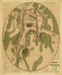
Field of Gettysburg, July 1st, 2nd & 3rd, 1863 Prepared by T. Ditterline.
Ditterline, T. (Theodore).
CREATED/PUBLISHED
[Philada. P. S. Duval & Son lith. 1863]
NOTES
Scale ca. 1:25,500,.
Reference: LC Civil War Maps (2nd ed.), 331
From his Sketch of the battles of Gettysburg . . . New York, C. A. Alvord, 1863. 24 p.
Oval-shaped map depicting troop and artillery positions, relief by hachures, drainage, roads, railroads, and houses with names of residents.
Description derived from published bibliography.
SUBJECTS
Gettysburg, Battle of, Gettysburg, Pa., 1863--Maps.
Gettysburg (Pa.)--Maps.
Gettysburg, Battle of.
United States--Pennsylvania--Gettysburg.
MEDIUM
1 map col. 49 x 40 cm.
CALL NUMBER
G3824.G3S5 1863 .D42 CW 331
REPOSITORY
Library of Congress Geography and Map Division Washington, D.C. 20540-4650
DIGITAL ID
g3824g cw0331000 http://hdl.loc.gov/loc.gmd/g3824g.cw0331000
| PREVIOUS | NEXT | NEW SEARCH |