Map
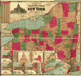
Panoramic view of New York City and vicinity.

| Format |
Map |
|---|---|
| Dates |
1912 |
| Location |
New York New York Metropolitan Area United States |
| Language |
English |
| Subjects |
New York (State) New York Metropolitan Area United States |
- Title
- Panoramic view of New York City and vicinity.
- Description
-
Bird's-eye view.
-
Available also through the Library of Congress Web site as a raster image.
-
1 view : col. ; 51 x 71 cm.
- Created Published
-
[New York] : Jacob Ruppert, c1912
- Subject Headings
-
-
New York Metropolitan Area
-
-
United States--New York (State)--New York Metropolitan Area.
- Notes
-
-
Bird's-eye view.
-
-
Available also through the Library of Congress Web site as a raster image.
- Medium
-
1 view : col. ; 51 x 71 cm.
- Call Number
-
G3804.N4A3 1912 .P3
- Repository
-
Library of Congress Geography and Map Division Washington, D.C. 20540-4650 USA dcu
- Digital Id
-
g3804n ct002193 http://hdl.loc.gov/loc.gmd/g3804n.ct002193
- Library of Congress Catalog Number
- 2010587909
Rights & Access
The maps in the Map Collections materials were either published prior to 1922, produced by the United States government, or both (see catalogue records that accompany each map for information regarding date of publication and source). The Library of Congress is providing access to these materials for educational and research purposes and is not aware of any U.S. copyright protection (see Title 17 of the United States Code) or any other restrictions in the Map Collection materials.
Note that the written permission of the copyright owners and/or other rights holders (such as publicity and/or privacy rights) is required for distribution, reproduction, or other use of protected items beyond that allowed by fair use or other statutory exemptions. Responsibility for making an independent legal assessment of an item and securing any necessary permissions ultimately rests with persons desiring to use the item.
More about Copyright and other Restrictions
For guidance about compiling full citations consult Citing Primary Sources.
Part of...
-
Panoramic Maps
[1461]
-
Cities And Towns
[1965]
-
Geography And Maps Division
[60803]
-
American Memory
[1121009]
More maps like this
-
 Topographical map of the city and county of New-York, and the adjacent country : with views in the border of the principal buildings, and interesting ...
Contributor:
J.H. Colton & Co
Site:
American Memory-cultural, Main Catalog
Original Format:
Map
Date:
1836
View catalog record
Topographical map of the city and county of New-York, and the adjacent country : with views in the border of the principal buildings, and interesting ...
Contributor:
J.H. Colton & Co
Site:
American Memory-cultural, Main Catalog
Original Format:
Map
Date:
1836
View catalog record
-
 Distance map of the state of New York : containing all the towns in the state.
Contributor:
Ensigns & Thayer
Site:
American Memory-cultural, Main Catalog
Original Format:
Map
Date:
1849
View catalog record
Distance map of the state of New York : containing all the towns in the state.
Contributor:
Ensigns & Thayer
Site:
American Memory-cultural, Main Catalog
Original Format:
Map
Date:
1849
View catalog record
-

 State of New-York for Spafford's gazetteer /
Contributor:
Spafford, Horatio Gates
Site:
Main Catalog
Original Format:
Map
Date:
1813
State of New-York for Spafford's gazetteer /
Contributor:
Spafford, Horatio Gates
Site:
Main Catalog
Original Format:
Map
Date:
1813
-
 New York /
Contributor:
Tanner, Henry Schenck
Site:
American Memory-cultural, Main Catalog
Original Format:
Map
Date:
1823
View catalog record
New York /
Contributor:
Tanner, Henry Schenck
Site:
American Memory-cultural, Main Catalog
Original Format:
Map
Date:
1823
View catalog record
-
 Map of the State of New York.
Contributor:
De Witt, Simeon
Site:
American Memory-cultural, Main Catalog
Original Format:
Map
Date:
1802
View catalog record
Map of the State of New York.
Contributor:
De Witt, Simeon
Site:
American Memory-cultural, Main Catalog
Original Format:
Map
Date:
1802
View catalog record
-
 N.W. parts of New York, no. 156.
Site:
American Memory-cultural, Main Catalog
Original Format:
Map
Date:
1750
View catalog record
N.W. parts of New York, no. 156.
Site:
American Memory-cultural, Main Catalog
Original Format:
Map
Date:
1750
View catalog record
-
 A map of the State of New York.
Contributor:
De Witt, Simeon
Site:
American Memory-cultural, Main Catalog
Original Format:
Map
Date:
1804
View catalog record
A map of the State of New York.
Contributor:
De Witt, Simeon
Site:
American Memory-cultural, Main Catalog
Original Format:
Map
Date:
1804
View catalog record
-
 Map of New York exhibiting the post offices, post roads, canals, rail roads &c. By David H. Burr; (Late topographer to the Post Office.) Geographer ...
Contributor:
Burr, David H.
Site:
American Memory-cultural, Main Catalog
Original Format:
Map
Date:
1839
View catalog record
Map of New York exhibiting the post offices, post roads, canals, rail roads &c. By David H. Burr; (Late topographer to the Post Office.) Geographer ...
Contributor:
Burr, David H.
Site:
American Memory-cultural, Main Catalog
Original Format:
Map
Date:
1839
View catalog record
-
 Asher & Adams' New York and part of Ontario.
Contributor:
Asher & Adams
Site:
American Memory-cultural, Main Catalog
Original Format:
Map
Date:
1871
View catalog record
Asher & Adams' New York and part of Ontario.
Contributor:
Asher & Adams
Site:
American Memory-cultural, Main Catalog
Original Format:
Map
Date:
1871
View catalog record
-
 Map of the northern parts of New York.
Site:
American Memory-cultural, Main Catalog
Original Format:
Map
Date:
1758
View catalog record
Map of the northern parts of New York.
Site:
American Memory-cultural, Main Catalog
Original Format:
Map
Date:
1758
View catalog record
-
 Map of the rail roads of the state of New York showing the stations, distances & connections with other roads; Thos. Pentingale, L.P. Behn.
Contributor:
Petingale, Thomas
Site:
American Memory-cultural, Main Catalog
Original Format:
Map
Date:
1858
View catalog record
Map of the rail roads of the state of New York showing the stations, distances & connections with other roads; Thos. Pentingale, L.P. Behn.
Contributor:
Petingale, Thomas
Site:
American Memory-cultural, Main Catalog
Original Format:
Map
Date:
1858
View catalog record
-
 Railroad map of the state of New York to accompany the twelfth annual report of the Board of Railroad Commissioners of the State of New ...
Contributor:
G.W. & C.B. Colton & Co
Site:
American Memory-cultural, Main Catalog
Original Format:
Map
Date:
1894
View catalog record
Railroad map of the state of New York to accompany the twelfth annual report of the Board of Railroad Commissioners of the State of New ...
Contributor:
G.W. & C.B. Colton & Co
Site:
American Memory-cultural, Main Catalog
Original Format:
Map
Date:
1894
View catalog record
-
 Bridgman's new rail road & township map of New York from the latest official & other authentic sources adapted for use in institutions of learning, ...
Contributor:
Bridgman, E. C.
Site:
American Memory-cultural, Main Catalog
Original Format:
Map
Date:
1896
View catalog record
Bridgman's new rail road & township map of New York from the latest official & other authentic sources adapted for use in institutions of learning, ...
Contributor:
Bridgman, E. C.
Site:
American Memory-cultural, Main Catalog
Original Format:
Map
Date:
1896
View catalog record
-
 A chorographical map of the Province of New-York in North America, divided into counties, manors, patents and townships; exhibiting likewise all the private grants of ...
Contributor:
Sauthier, Claude Joseph
Site:
American Memory-cultural, Main Catalog
Original Format:
Map
Date:
1779
View catalog record
A chorographical map of the Province of New-York in North America, divided into counties, manors, patents and townships; exhibiting likewise all the private grants of ...
Contributor:
Sauthier, Claude Joseph
Site:
American Memory-cultural, Main Catalog
Original Format:
Map
Date:
1779
View catalog record
-
 The city of New York.
Site:
American Memory-cultural, Main Catalog
Original Format:
Map
Date:
1883
View catalog record
The city of New York.
Site:
American Memory-cultural, Main Catalog
Original Format:
Map
Date:
1883
View catalog record
-
 Map of the new subway of greater New York : (Interborrow system)
Contributor:
Manhattan Publishing Company
Site:
American Memory-cultural, Main Catalog
Original Format:
Map
Date:
1918
View catalog record
Map of the new subway of greater New York : (Interborrow system)
Contributor:
Manhattan Publishing Company
Site:
American Memory-cultural, Main Catalog
Original Format:
Map
Date:
1918
View catalog record
You might also like
-
 New York State and Metropolitan Area employment trends.
Site:
Main Catalog
Original Format:
Book
Date:
2004
New York State and Metropolitan Area employment trends.
Site:
Main Catalog
Original Format:
Book
Date:
2004
-
Rand, McNally New York guide to the city and environs, with map and illustrations...
Site:
Main Catalog
Original Format:
Book
Date:
1918
-
Illustrierter führer durch New York u. umgebung,
Contributor:
Schultze-Altenwalde, H. W.
Site:
Main Catalog
Original Format:
Book
Date:
1908
-
-
Appleton's New York city and vicinity guide ...
Contributor:
Williams, W.
Site:
Main Catalog
Original Format:
Book
Date:
1849
-
 Interview with Tenisha Semidey, New York, New York, November 18, 2001
Contributor:
Rivas, Shalena, Semidey, Tenisha
Site:
American Memory-cultural
Original Format:
Audio
Date:
2001-11-18
Interview with Tenisha Semidey, New York, New York, November 18, 2001
Contributor:
Rivas, Shalena, Semidey, Tenisha
Site:
American Memory-cultural
Original Format:
Audio
Date:
2001-11-18