- Eaglelux Traffic Signal - manufactured by Eagle Signal Comp. - ed.tapanes
- Users can add notes anywhere in the Photo. - canqiang_fu
- I thought lighted traffic signals
weren't around until after the war?? - GM1953 - Might have been a signal for the railroad. - brealytrent
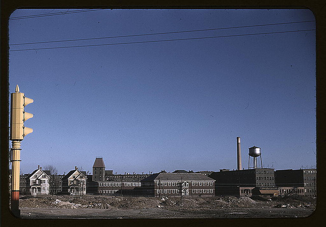
[Douglas Shoe Factory, Spark St., Brockton, Mass.] (LOC)
Delano, Jack,, photographer.
[Douglas Shoe Factory, Spark St., Brockton, Mass.]
ca. 1940 Dec.
1 slide : color.
Notes:
Current title devised by Library staff from information provided by
the source: Flickr Commons project, 2008.
Original title from FSA or OWI agency caption: Industrial buildings
and a town in Mass., possibly Brockton.
Transfer from U.S. Office of War Information, 1944.
Subjects:
Factories
Shoe industry
United States--Massachusetts--Brockton
Format: Slides--Color
Rights Info: No known restrictions on publication.
Repository: Library of Congress, Prints and Photographs Division, Washington, D.C. 20540 USA, hdl.loc.gov/loc.pnp/pp.print
Part Of: Farm Security Administration - Office of War Information Collection 11671-1 (DLC) 93845501
General information about the FSA/OWI Color Photographs is available at hdl.loc.gov/loc.pnp/pp.fsac
Persistent URL: hdl.loc.gov/loc.pnp/fsac.1a33862
Call Number: LC-USF35-14


![[Children with adult in the tenement district, Brockton, Massachusetts] (LOC)](https://cybercemetery.unt.edu/archive/oilspill/20121207060343im_/http://farm3.staticflickr.com/2098/2179042766_d53af1cc8e_s.jpg)
![[Train and several sets of railroad tracks in the snow, Massachusetts] (LOC)](https://cybercemetery.unt.edu/archive/oilspill/20121207060343im_/http://farm3.staticflickr.com/2113/2179043086_26d3dbecde_s.jpg)

Comments and faves
susan_fenton1, Dan //, JaySeaAre, andrew d miller, and 28 other people added this photo to their favorites.
youzoid (59 months ago | reply)
beautiful image - inspiring.
susan_fenton1 (59 months ago | reply)
My father worked in the shoe industry in Brockton with his father and brothers. They had a factory on Spark St. He recognized this photo as the WL Douglas Shoe Factory, also on Spark St in Brockton. He's pretty sure all the buildings are part of the same factory. Douglas was a mayor of Brockton and governor of Massachusetts in the late 1800's - early 1900's.
rrsafety (59 months ago | reply)
Yahoo maps is best for this one:
Go to "201 Spark St Brockton MA 02302" and view the satellite image. You'll see the two houses on the left of the photo. Looks like the brown buildings have been torn down, but the grey buildings in the back are now painted white and still stand. View them at MSN Live Maps and click on the "birdseye" option.
AntyDiluvian (59 months ago | reply)
Looks like this was taken from the corner of Howard and North Montello Streets in Brockton. There were -- and still are -- railroad tracks out there by those piles and mounds. I used to walk here every day in the summer -- sometimes along the street, sometimes along the tracks -- on my way to and from the Montello Pool, just north of here.
bren_tommy (55 months ago | reply)
my dad worked there back in his day
7dayWKND (51 months ago | reply)
No actually the whole complex burned in a fire about 10, 15 years ago. The white bldgs are new and theres a new industrial blg. Suprisingly, those two houses off to the left are still standing today.
striatic (47 months ago | reply)
This image has been used in the indicommons.org post: Flickring across the Library of Congress