Searching Tips
Home
Subject Map
Select a subject
---------------
Arts & Music
Health & Phys Ed
History & Soc Studies
- U.S. History Topics
- U.S. Time Periods
- World Studies
Language Arts
Math
Science
---------------
Subject map
Arts & Music
Health & Phys Ed
History & Soc Studies
U.S. History Topics
U.S. Time Periods
World Studies
Language Arts
Math
Science
What's New
Calendar
Maps
30 Resources
Nationalatlas.gov
is a primary source of U.S. maps and geographic information. Zoom in on your state and...
Census in Schools
offers lesson plans, fact sheets, and activities for learning about the 2010 census. How...
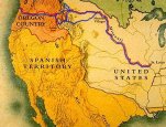
Lewis and Clark: Mapping the West
features maps of the famous expedition. The Corps of Discovery collected 30 maps from...
Lewis and Clark as Naturalists
presents flora and fauna as they described it on their 3,700-mile journey launched in St...
Interior Dept
U.S. Census Bureau
Smithsonian Institution
Smithsonian Institution
See All 30 maps Resources
About FREE
Privacy
Security
Disclaimer
WhiteHouse.gov
USA.gov