Searching Tips
Home
Subject Map
Select a subject
---------------
Arts & Music
Health & Phys Ed
History & Soc Studies
- U.S. History Topics
- U.S. Time Periods
- World Studies
Language Arts
Math
Science
---------------
Subject map
Arts & Music
Health & Phys Ed
History & Soc Studies
U.S. History Topics
U.S. Time Periods
World Studies
Language Arts
Math
Science
What's New
Calendar
Maps
30 Resources
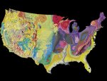
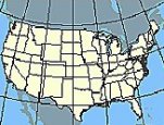
Nationalatlas.gov
is a primary source of U.S. maps and geographic information. Zoom in on your state and...
Historic Maps in K-12 Classrooms
offers lesson plans built around historically important maps on 18 topics: Columbus's...
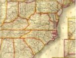
Map Collections: 1544-1996
offers thousands of digitized online maps. The collections are broken into seven...
Geology at the U.S. Geological Survey
provides resource collections and maps for studying earthquakes, hurricanes, floods...
Interior Dept
Endowment for Humanities
Library of Congress
U.S. Geological Survey
See All 30 maps Resources
About FREE
Privacy
Security
Disclaimer
WhiteHouse.gov
USA.gov


![District of Columbia. Bradford, T. G. 1802-1887. (Thomas Gamaliel),Published [Boston : T.G. Bradford, 1835]. Shows major streets and buildings.](https://cybercemetery.unt.edu/archive/oilspill/20130221125411im_/http://www.free.ed.gov/images/resources/map.jpg)