Map
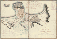
Plan of the siege of St. Sebastian in the year 1813.

| Format |
Map |
|---|---|
| Dates |
1813 |
| Location |
San SebastiáN San SebastiáN Spain |
| Language |
English |
| Subjects |
History Peninsular War San SebastiáN San SebastiáN (Spain) Siege Spain |
- Title
- Plan of the siege of St. Sebastian in the year 1813.
- Description
-
Relief shown by hachures.
-
Shows left and right attacks against San Sebastian from July to September 1813.
-
Pen-and-ink and watercolor.
-
Indexed.
-
Mounted on cloth backing.
-
Minimal level cataloging record.
-
Available also through the Library of Congress Web site as a raster image.
-
1 ms. map : col. ; 60 x 60 cm.
- Created Published
-
1813.
- Subject Headings
-
-
San Sebastián (Spain)
-
-
San Sebastián (Spain)--History--Siege, 1813
-
-
Peninsular War, 1807-1814--Spain
-
-
Spain--San Sebastián.
- Notes
-
-
Relief shown by hachures.
-
-
Shows left and right attacks against San Sebastian from July to September 1813.
-
-
Pen-and-ink and watercolor.
-
-
Indexed.
-
-
Mounted on cloth backing.
-
-
Minimal level cataloging record.
-
-
Available also through the Library of Congress Web site as a raster image.
- Medium
-
1 ms. map : col. ; 60 x 60 cm.
- Call Number
-
G6564.S4 1813 .P5
- Repository
-
Library of Congress Geography and Map Division Washington, D.C. 20540-4650 USA dcu
- Digital Id
-
g6564s hl000018 http://hdl.loc.gov/loc.gmd/g6564s.hl000018
- Library of Congress Catalog Number
- 2010589559
Rights & Access
The maps in the Map Collections materials were either published prior to 1922, produced by the United States government, or both (see catalogue records that accompany each map for information regarding date of publication and source). The Library of Congress is providing access to these materials for educational and research purposes and is not aware of any U.S. copyright protection (see Title 17 of the United States Code) or any other restrictions in the Map Collection materials.
Note that the written permission of the copyright owners and/or other rights holders (such as publicity and/or privacy rights) is required for distribution, reproduction, or other use of protected items beyond that allowed by fair use or other statutory exemptions. Responsibility for making an independent legal assessment of an item and securing any necessary permissions ultimately rests with persons desiring to use the item.
More about Copyright and other Restrictions
For guidance about compiling full citations consult Citing Primary Sources.
Part of...
-
General Maps
[2477]
-
Military Battles And Campaigns Cartographic Items
[3867]
-
Geography And Maps Division
[60803]
-
American Memory
[1121009]
More maps like this
-

 Sketch of the surprise of the French troups under General Girard by Lt. Gen. Hill of the allied army near Arrojo de los Molinos, 28th ...
Contributor:
Hartmann, George
Site:
Main Catalog
Original Format:
Map
Date:
1811
Sketch of the surprise of the French troups under General Girard by Lt. Gen. Hill of the allied army near Arrojo de los Molinos, 28th ...
Contributor:
Hartmann, George
Site:
Main Catalog
Original Format:
Map
Date:
1811
-
 Sketch of the country between the Coa & Sierra de Gata /
Contributor:
Hartmann, George
Site:
American Memory-cultural, Main Catalog
Original Format:
Map
Date:
1812
View catalog record
Sketch of the country between the Coa & Sierra de Gata /
Contributor:
Hartmann, George
Site:
American Memory-cultural, Main Catalog
Original Format:
Map
Date:
1812
View catalog record
-
 Position of the 2 armies during the greatest part of the 28th July and at the attack on the center of the British & Spanish ...
Contributor:
Hartmann, George
Site:
American Memory-cultural, Main Catalog
Original Format:
Map
Date:
1809
View catalog record
Position of the 2 armies during the greatest part of the 28th July and at the attack on the center of the British & Spanish ...
Contributor:
Hartmann, George
Site:
American Memory-cultural, Main Catalog
Original Format:
Map
Date:
1809
View catalog record
-
 't Eÿland Curacao, anno 1800 : [illegible].
Site:
American Memory-cultural, Main Catalog
Original Format:
Map
Date:
1800
View catalog record
't Eÿland Curacao, anno 1800 : [illegible].
Site:
American Memory-cultural, Main Catalog
Original Format:
Map
Date:
1800
View catalog record
-
 A Plan of the siege of the Havana. Drawn by an officer.15th August 1762., Plan of the city and harbour of Havanna.
Site:
American Memory-cultural, Main Catalog
Original Format:
Map
Date:
1763
View catalog record
A Plan of the siege of the Havana. Drawn by an officer.15th August 1762., Plan of the city and harbour of Havanna.
Site:
American Memory-cultural, Main Catalog
Original Format:
Map
Date:
1763
View catalog record
-
 Plan of the siege of the Havana surrenderid [sic] Aug. 12, 1762 to the English commanded by the Earl of Albemarle General and Sir George ...
Contributor:
Hawk, James
Site:
American Memory-cultural, Main Catalog
Original Format:
Map
Date:
1762
View catalog record
Plan of the siege of the Havana surrenderid [sic] Aug. 12, 1762 to the English commanded by the Earl of Albemarle General and Sir George ...
Contributor:
Hawk, James
Site:
American Memory-cultural, Main Catalog
Original Format:
Map
Date:
1762
View catalog record
-
 Carta militar das principaes estradas de Portugal /
Contributor:
Homem, Lourenço, Homem, Lourenço
Site:
American Memory-cultural, Main Catalog
Original Format:
Map
Date:
1808
View catalog record
Carta militar das principaes estradas de Portugal /
Contributor:
Homem, Lourenço, Homem, Lourenço
Site:
American Memory-cultural, Main Catalog
Original Format:
Map
Date:
1808
View catalog record
-
 Map of the siege of Vicksburg. [1864].
Contributor:
Badeau, Adam
Site:
American Memory-cultural, Main Catalog
Original Format:
Map
Date:
1885
View catalog record
Map of the siege of Vicksburg. [1864].
Contributor:
Badeau, Adam
Site:
American Memory-cultural, Main Catalog
Original Format:
Map
Date:
1885
View catalog record
-
 Carte de la partie de la Virginie ou l'armée combinée de France & des États-Unis de l'Amérique a fait prisonnière l'Armée anglaise commandée par Lord ...
Contributor:
Esnauts et Rapilly
Site:
American Memory-cultural, Main Catalog
Original Format:
Map
Date:
1781
View catalog record
Carte de la partie de la Virginie ou l'armée combinée de France & des États-Unis de l'Amérique a fait prisonnière l'Armée anglaise commandée par Lord ...
Contributor:
Esnauts et Rapilly
Site:
American Memory-cultural, Main Catalog
Original Format:
Map
Date:
1781
View catalog record
-
 To His Excellency Genl. Washington, Commander in Chief of the armies of the United States of America, this plan of the investment of York and ...
Contributor:
Bauman, Sebastian
Site:
American Memory-cultural, Main Catalog
Original Format:
Map
Date:
1782
View catalog record
To His Excellency Genl. Washington, Commander in Chief of the armies of the United States of America, this plan of the investment of York and ...
Contributor:
Bauman, Sebastian
Site:
American Memory-cultural, Main Catalog
Original Format:
Map
Date:
1782
View catalog record
-
 Battery on Turner's rocks : [Georgia].
Site:
American Memory-cultural, Main Catalog
Original Format:
Map
Date:
1864
View catalog record
Battery on Turner's rocks : [Georgia].
Site:
American Memory-cultural, Main Catalog
Original Format:
Map
Date:
1864
View catalog record
-
 Defense Mapping Agency Bicentennial commemorative memento of the Battle of Yorktown : to His Excellency Gen'l Washington, commander in chief of the armies of the ...
Contributor:
Bauman, Sebastian
Site:
American Memory-cultural, Main Catalog
Original Format:
Map
Date:
1981
View catalog record
Defense Mapping Agency Bicentennial commemorative memento of the Battle of Yorktown : to His Excellency Gen'l Washington, commander in chief of the armies of the ...
Contributor:
Bauman, Sebastian
Site:
American Memory-cultural, Main Catalog
Original Format:
Map
Date:
1981
View catalog record
-
 A plan of Fort St. Louis, St. Joseph, St. Jago & of St. Philip scituated at ye entrance of Cartagena Harbour or Boca-Chica with ye ...
Contributor:
Thomas, John
Site:
American Memory-cultural, Main Catalog
Original Format:
Map
Date:
1741
View catalog record
A plan of Fort St. Louis, St. Joseph, St. Jago & of St. Philip scituated at ye entrance of Cartagena Harbour or Boca-Chica with ye ...
Contributor:
Thomas, John
Site:
American Memory-cultural, Main Catalog
Original Format:
Map
Date:
1741
View catalog record
-
 Carte generale des colonies angloises dans l'Amerique Septentrionale pour l'intelligence de la guerre presente, d'apres des manuscrit anglais par J. B. Nolin geographe. Corrigé, augmenté ...
Contributor:
Phelipeau, Ren, Phelipeau, Rene
Site:
American Memory-cultural, Main Catalog
Original Format:
Map
Date:
1783
View catalog record
Carte generale des colonies angloises dans l'Amerique Septentrionale pour l'intelligence de la guerre presente, d'apres des manuscrit anglais par J. B. Nolin geographe. Corrigé, augmenté ...
Contributor:
Phelipeau, Ren, Phelipeau, Rene
Site:
American Memory-cultural, Main Catalog
Original Format:
Map
Date:
1783
View catalog record
-
 Map of Jackson, Miss: and surroundings during the siege July 10th-16th, 1863, and location of the Cooper home whence a piano was carried by a ...
Contributor:
Duff, William H.
Site:
American Memory-cultural, Main Catalog
Original Format:
Map
Date:
1908
View catalog record
Map of Jackson, Miss: and surroundings during the siege July 10th-16th, 1863, and location of the Cooper home whence a piano was carried by a ...
Contributor:
Duff, William H.
Site:
American Memory-cultural, Main Catalog
Original Format:
Map
Date:
1908
View catalog record
-
 [Map of the siege of Petersburg, 1864-5 /
Contributor:
Weyss, J. E.
Site:
American Memory-cultural, Main Catalog
Original Format:
Map
Date:
1865
View catalog record
[Map of the siege of Petersburg, 1864-5 /
Contributor:
Weyss, J. E.
Site:
American Memory-cultural, Main Catalog
Original Format:
Map
Date:
1865
View catalog record
You might also like
-
 Views of Barcelona, Hondarribia, and San Sebastián, Spain
Contributor:
Photoglob Co
Site:
Prints & Photographs
Original Format:
Photo, Print, Drawing
Date:
1890
Views of Barcelona, Hondarribia, and San Sebastián, Spain
Contributor:
Photoglob Co
Site:
Prints & Photographs
Original Format:
Photo, Print, Drawing
Date:
1890
-
 Die Deutschen Mädel und Jungen in San Sebastian
Site:
Prints & Photographs, Main Catalog
Original Format:
Photo, Print, Drawing
Date:
1937
View catalog record
Die Deutschen Mädel und Jungen in San Sebastian
Site:
Prints & Photographs, Main Catalog
Original Format:
Photo, Print, Drawing
Date:
1937
View catalog record
-
 San Sebastian, Puerto Rico (vicinity). Farmer's son on a road
Contributor:
Delano, Jack
Site:
Prints & Photographs
Original Format:
Photo, Print, Drawing
Date:
1942
San Sebastian, Puerto Rico (vicinity). Farmer's son on a road
Contributor:
Delano, Jack
Site:
Prints & Photographs
Original Format:
Photo, Print, Drawing
Date:
1942
-
 San Sebastian, Puerto Rico. Farm laborer's wife living in the hills
Contributor:
Delano, Jack
Site:
Prints & Photographs
Original Format:
Photo, Print, Drawing
Date:
1942
San Sebastian, Puerto Rico. Farm laborer's wife living in the hills
Contributor:
Delano, Jack
Site:
Prints & Photographs
Original Format:
Photo, Print, Drawing
Date:
1942
-
 San Sebastian, Puerto Rico (vicinity). Four persons live in the shack. All are farm laborers working in the nearby cane fields
Contributor:
Delano, Jack
Site:
Prints & Photographs
Original Format:
Photo, Print, Drawing
Date:
1942
San Sebastian, Puerto Rico (vicinity). Four persons live in the shack. All are farm laborers working in the nearby cane fields
Contributor:
Delano, Jack
Site:
Prints & Photographs
Original Format:
Photo, Print, Drawing
Date:
1942
-
 San Sebastian, Puerto Rico (vicinity). President of a FSA (Farm Security Administration) crane cooperative. There are thirteen members collectively using this crane for loading their ...
Contributor:
Delano, Jack
Site:
Prints & Photographs
Original Format:
Photo, Print, Drawing
Date:
1942
San Sebastian, Puerto Rico (vicinity). President of a FSA (Farm Security Administration) crane cooperative. There are thirteen members collectively using this crane for loading their ...
Contributor:
Delano, Jack
Site:
Prints & Photographs
Original Format:
Photo, Print, Drawing
Date:
1942