Map
Peruuiae avriferæ regionis typus /
Views

More Views

| Format |
Map |
|---|---|
| Contributors |
Ortelius, Abraham |
| Dates |
1584 |
| Location |
America Florida Mexico United States |
| Language |
Latin |
| Subjects |
America Florida Mexico United States |
- Title
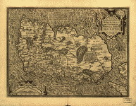
- Peruuiae avriferæ regionis typus /
- Description
-
Shows portion of Central America, northwestern South America, southern United States, and coast of Tamaulipas in Mexico.
-
Relief shown pictorially.
-
Appears in the author's Theatrum orbis terrarum.
-
Includes ill.
-
Text on verso.
-
Available also through the Library of Congress Web site as a raster image.
-
3 maps on 1 sheet : hand col. ; 32 x 21 cm. or smaller, sheet 44 x 56 cm.
- Creator
- Ortelius, Abraham,
- Created Published
-
[S.l. : s.n., 1584]
- Subject Headings
-
-
America
-
-
America.
-
-
United States--Florida.
-
-
Mexico.
- Notes
-
-
Shows portion of Central America, northwestern South America, southern United States, and coast of Tamaulipas in Mexico.
-
-
Relief shown pictorially.
-
-
Appears in the author's Theatrum orbis terrarum.
-
-
Includes ill.
-
-
Text on verso.
-
-
Available also through the Library of Congress Web site as a raster image.
- Medium
-
3 maps on 1 sheet : hand col. ; 32 x 21 cm. or smaller, sheet 44 x 56 cm.
- Call Number
-
G3290 1584 .O7
- Repository
-
Library of Congress Geography and Map Division Washington, D.C. 20540-4650 USA dcu
- Digital Id
-
g3290 ct001038r http://hdl.loc.gov/loc.gmd/g3290.ct001038r
-
g3290 ct001038v http://hdl.loc.gov/loc.gmd/g3290.ct001038v
- Library of Congress Catalog Number
- 84696980
Rights & Access
The maps in the Map Collections materials were either published prior to 1922, produced by the United States government, or both (see catalogue records that accompany each map for information regarding date of publication and source). The Library of Congress is providing access to these materials for educational and research purposes and is not aware of any U.S. copyright protection (see Title 17 of the United States Code) or any other restrictions in the Map Collection materials.
Note that the written permission of the copyright owners and/or other rights holders (such as publicity and/or privacy rights) is required for distribution, reproduction, or other use of protected items beyond that allowed by fair use or other statutory exemptions. Responsibility for making an independent legal assessment of an item and securing any necessary permissions ultimately rests with persons desiring to use the item.
More about Copyright and other Restrictions
For guidance about compiling full citations consult Citing Primary Sources.
Part of...
-
Louisiana: European Explorations And The Louisiana Purchase
[77]
-
Discovery And Exploration
[150]
-
Geography And Maps Division
[60803]
-
American Memory
[1121009]
More maps like this
-
 Theatrum orbis terrarum.
Contributor:
Ortelius, Abraham
Site:
American Memory-cultural, Main Catalog
Original Format:
Map
Date:
1570
View catalog record
Theatrum orbis terrarum.
Contributor:
Ortelius, Abraham
Site:
American Memory-cultural, Main Catalog
Original Format:
Map
Date:
1570
View catalog record
-
 Portugalliae : que olim Lusitania, nouissima & exactissima descriptio /
Contributor:
Ortelius, Abraham
Site:
American Memory-cultural, Main Catalog
Original Format:
Map
Date:
1579
View catalog record
Portugalliae : que olim Lusitania, nouissima & exactissima descriptio /
Contributor:
Ortelius, Abraham
Site:
American Memory-cultural, Main Catalog
Original Format:
Map
Date:
1579
View catalog record
-
 Theatrum orbis terrarum.
Contributor:
Ortelius, Abraham
Site:
American Memory-cultural, Main Catalog
Original Format:
Map
Date:
1570
View catalog record
Theatrum orbis terrarum.
Contributor:
Ortelius, Abraham
Site:
American Memory-cultural, Main Catalog
Original Format:
Map
Date:
1570
View catalog record
-
 Tartariae sive Magni Chami Regni tÿpus.
Contributor:
Ortelius, Abraham
Site:
American Memory-cultural, Main Catalog
Original Format:
Map
Date:
1603
View catalog record
Tartariae sive Magni Chami Regni tÿpus.
Contributor:
Ortelius, Abraham
Site:
American Memory-cultural, Main Catalog
Original Format:
Map
Date:
1603
View catalog record
-
 Hiberniae, Britannicae Insvlae nova descripto.
Contributor:
Ortelius, Abraham
Site:
American Memory-cultural, Main Catalog
Original Format:
Map
Date:
1598
View catalog record
Hiberniae, Britannicae Insvlae nova descripto.
Contributor:
Ortelius, Abraham
Site:
American Memory-cultural, Main Catalog
Original Format:
Map
Date:
1598
View catalog record
-
 [Map of the Gulf Coast from Florida to Mexico].
Contributor:
Vinckeboons, Joan
Site:
American Memory-cultural, Main Catalog
Original Format:
Map
Date:
1639
View catalog record
[Map of the Gulf Coast from Florida to Mexico].
Contributor:
Vinckeboons, Joan
Site:
American Memory-cultural, Main Catalog
Original Format:
Map
Date:
1639
View catalog record
-
[Map of the Gulf Coast from Florida to Mexico].
Contributor:
Vinckeboons, Joan
Site:
American Memory-cultural, Main Catalog
Original Format:
Map
Date:
1639
View catalog record
-
 Tabula Mexicae et Floridae : terrarum Anglicarum, et anteriorum Americae insularum, item cursuum et circuituum fluminis Mississipi dicti.
Contributor:
Schenk, Peter
Site:
American Memory-cultural, Main Catalog
Original Format:
Map
Date:
1710
View catalog record
Tabula Mexicae et Floridae : terrarum Anglicarum, et anteriorum Americae insularum, item cursuum et circuituum fluminis Mississipi dicti.
Contributor:
Schenk, Peter
Site:
American Memory-cultural, Main Catalog
Original Format:
Map
Date:
1710
View catalog record
-
 Map of the state of Florida /
Contributor:
United States. War Dept. Corps of Engineers
Site:
American Memory-cultural, Main Catalog
Original Format:
Map
Date:
1875
View catalog record
Map of the state of Florida /
Contributor:
United States. War Dept. Corps of Engineers
Site:
American Memory-cultural, Main Catalog
Original Format:
Map
Date:
1875
View catalog record
-
 A new sectional map of Florida issued by the land department of the South Florida R. R. Co. and the Plant Investment Co.
Contributor:
Elliott, D. H.
Site:
American Memory-cultural, Main Catalog
Original Format:
Map
Date:
1888
View catalog record
A new sectional map of Florida issued by the land department of the South Florida R. R. Co. and the Plant Investment Co.
Contributor:
Elliott, D. H.
Site:
American Memory-cultural, Main Catalog
Original Format:
Map
Date:
1888
View catalog record
-
 Northern part of Florida
Contributor:
Lindenkohl, H.
Site:
American Memory-cultural, Main Catalog
Original Format:
Map
Date:
1864
View catalog record
Northern part of Florida
Contributor:
Lindenkohl, H.
Site:
American Memory-cultural, Main Catalog
Original Format:
Map
Date:
1864
View catalog record
-
 State of Florida; base map /
Contributor:
Geological Survey (U.S.)
Site:
American Memory-cultural, Main Catalog
Original Format:
Map
Date:
1940
View catalog record
State of Florida; base map /
Contributor:
Geological Survey (U.S.)
Site:
American Memory-cultural, Main Catalog
Original Format:
Map
Date:
1940
View catalog record
-
 The State of Florida.
Contributor:
Bruff, Joseph Goldsborough
Site:
American Memory-cultural, Main Catalog
Original Format:
Map
Date:
1846
View catalog record
The State of Florida.
Contributor:
Bruff, Joseph Goldsborough
Site:
American Memory-cultural, Main Catalog
Original Format:
Map
Date:
1846
View catalog record
-
 Map of the State of Florida showing the progress of the surveys; from the annual report of the Surveyor General for 1856.
Contributor:
Drew, Columbus
Site:
American Memory-cultural, Main Catalog
Original Format:
Map
Date:
1856
View catalog record
Map of the State of Florida showing the progress of the surveys; from the annual report of the Surveyor General for 1856.
Contributor:
Drew, Columbus
Site:
American Memory-cultural, Main Catalog
Original Format:
Map
Date:
1856
View catalog record
-
 Map of Florida.
Contributor:
Vignoles, Charles Blacker
Site:
American Memory-cultural, Main Catalog
Original Format:
Map
Date:
1823
View catalog record
Map of Florida.
Contributor:
Vignoles, Charles Blacker
Site:
American Memory-cultural, Main Catalog
Original Format:
Map
Date:
1823
View catalog record
-
 Seat of War.
Contributor:
United States. Army. Corps of Engineers
Site:
American Memory-cultural, Main Catalog
Original Format:
Map
Date:
1839
View catalog record
Seat of War.
Contributor:
United States. Army. Corps of Engineers
Site:
American Memory-cultural, Main Catalog
Original Format:
Map
Date:
1839
View catalog record
You might also like
-
 Cypress woods, Florida
Contributor:
Highsmith, Carol M.
Site:
Prints & Photographs, Main Catalog
Original Format:
Photo, Print, Drawing
Date:
1980
View catalog record
Cypress woods, Florida
Contributor:
Highsmith, Carol M.
Site:
Prints & Photographs, Main Catalog
Original Format:
Photo, Print, Drawing
Date:
1980
View catalog record
-
 Seagulls at the Atlantic Ocean in Florida
Contributor:
Highsmith, Carol M.
Site:
Prints & Photographs, Main Catalog
Original Format:
Photo, Print, Drawing
Date:
1980
View catalog record
Seagulls at the Atlantic Ocean in Florida
Contributor:
Highsmith, Carol M.
Site:
Prints & Photographs, Main Catalog
Original Format:
Photo, Print, Drawing
Date:
1980
View catalog record
-
 Unique small theme park in southern Virginia
Contributor:
Highsmith, Carol M.
Site:
Prints & Photographs, Main Catalog
Original Format:
Photo, Print, Drawing
Date:
1980
View catalog record
Unique small theme park in southern Virginia
Contributor:
Highsmith, Carol M.
Site:
Prints & Photographs, Main Catalog
Original Format:
Photo, Print, Drawing
Date:
1980
View catalog record
-
 Parrot poses on a tree in Florida
Contributor:
Highsmith, Carol M.
Site:
Prints & Photographs, Main Catalog
Original Format:
Photo, Print, Drawing
Date:
1980
View catalog record
Parrot poses on a tree in Florida
Contributor:
Highsmith, Carol M.
Site:
Prints & Photographs, Main Catalog
Original Format:
Photo, Print, Drawing
Date:
1980
View catalog record
-
 Flamingos in Florida
Contributor:
Highsmith, Carol M.
Site:
Prints & Photographs, Main Catalog
Original Format:
Photo, Print, Drawing
Date:
1980
View catalog record
Flamingos in Florida
Contributor:
Highsmith, Carol M.
Site:
Prints & Photographs, Main Catalog
Original Format:
Photo, Print, Drawing
Date:
1980
View catalog record
-
 Florida flamingos
Contributor:
Highsmith, Carol M.
Site:
Prints & Photographs, Main Catalog
Original Format:
Photo, Print, Drawing
Date:
1980
View catalog record
Florida flamingos
Contributor:
Highsmith, Carol M.
Site:
Prints & Photographs, Main Catalog
Original Format:
Photo, Print, Drawing
Date:
1980
View catalog record