![[December 16, 1944], HQ Twelfth Army Group situation map.](https://cybercemetery.unt.edu/archive/oilspill/20121227124216im_/http://www.loc.gov/collections/static/world-war-ii-maps-military-situation-maps-from-1944-to-1945/images/ict21195.jpg)


![[January 18, 1945], HQ Twelfth Army Group situation map.](https://cybercemetery.unt.edu/archive/oilspill/20121227124216im_/http://www.loc.gov/collections/static/world-war-ii-maps-military-situation-maps-from-1944-to-1945/images/ict21228.jpg)


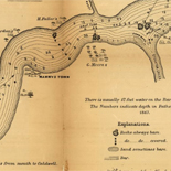
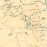
![Map of the Rappahannock River from [sic] Port Royal to Richards Ferry](https://cybercemetery.unt.edu/archive/oilspill/20121227124216im_/http://www.loc.gov/collections/static/civil-war-maps/images/cw0619600.jpg)
![[December 25, 1944], HQ Twelfth Army Group situation map.](https://cybercemetery.unt.edu/archive/oilspill/20121227124216im_/http://www.loc.gov/collections/static/world-war-ii-maps-military-situation-maps-from-1944-to-1945/images/ict21204.jpg)


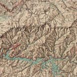
![Carte particulière d'une partie de la Louisianne ou les fleuve et rivierres [i.e. rivières] onts etés relevé a l'estime & les routtes [i.e. routes] par terre relevé & mesurées aux pas, par les Srs. Broutin, de Vergés, ingénieurs & Saucier dessinateur](https://cybercemetery.unt.edu/archive/oilspill/20121227124216im_/http://www.loc.gov/collections/static/louisiana-european-explorations-and-the-louisiana-purchase/images/ct000681.jpg)


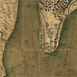
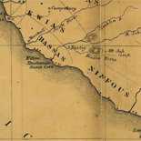
![[Sketch of the Manassas battlefield].](https://cybercemetery.unt.edu/archive/oilspill/20121227124216im_/http://www.loc.gov/collections/static/hotchkiss-maps/images/cwh00108.jpg)


Results
Refined by:
Original Format: Map-


Plattegrond van Groot-Roeselare / Catalog Record Only
Cover title.
Contributor: Geocart (Firm) Site: Main Catalog Original Format: Map Date: 1983 -
Chʻoesin Chʻungnam haengjŏng annaedo / Catalog Record Only
Relief shown by spot heights.
Contributor: Kyŏnghwasa. Pʻyŏnjippu Site: Main Catalog Original Format: Map Date: 1982 -
Sanborn Fire Insurance Map from Crisfield, Somerset County, Maryland.
502. 18 Sheet(s). Jan 1931 - Oct 1943.
Site: American Memory-cultural Original Format: Map Date: 1943 -
Altaĭskiĭ kraĭ, ėkonomicheskai︠a︡ karta dli︠a︡ sredneĭ shkoly : masshtab 1:1 000 000 / Catalog Record Only
Includes 2 graphs.
Contributor: Soviet Union. Glavnoe upravlenie geodezii i kartografii Site: Main Catalog Original Format: Map Date: 1981 -
Atlas of Moody County, South Dakota / Catalog Record Only
Includes rural directories.
Contributor: Midland Atlas Company Site: Main Catalog Original Format: Map Date: 1982 -
Matsuyama-kō kōwan keikakuzu. Catalog Record Only
Relief shown by contours and spot heights. Depths shown by contours.
Contributor: Ehime-ken (Japan). Dobokubu. Kōwan Kaiganka Site: Main Catalog Original Format: Map Date: 1999 -
Champion map of Reading, Pennsylvania. Catalog Record Only
Shows radial distances.
Contributor: Champion Map Corporation Site: Main Catalog Original Format: Map Date: 1991 -
Maps of DuPage County with Lombard, Villa Park, and Elmhurst, Illinois : happy to help you find your way around! / Catalog Record Only
Panel title.
Contributor: Merchant Maps (Firm) Site: Main Catalog Original Format: Map Date: 1983 -

Bird's eye view of the city of Lyons, Clinton Co., Iowa 1868.
Perspective map not drawn to scale.
Contributor: Ruger, A. Site: American Memory-cultural - Main Catalog Original Format: Map Date: 1868 View catalog record -
Town of Carbondale. Catalog Record Only
1 map ; on sheet 28 x 22 cm.
Site: Main Catalog Original Format: Map Date: 1981 -
Arizona, 1971 happy motoring guide. Catalog Record Only
Scale ca. 1:1,710,720; 1 in. equals about 27 miles.
Contributor: General Drafting Company Site: Main Catalog Original Format: Map Date: 1970 -
Sanborn Fire Insurance Map from Weiser, Washington County, Idaho.
20 Sheet(s). Jul 1928.
Site: American Memory-cultural Original Format: Map Date: 1928-01-01 -

Map of the state of New-York showing its water and rail road lines. Jan 1855, by direction of John T. Clark State Engineer & Surveyor.
Scale ca. 1:1,000,000.
Contributor: Vaughan, David Site: American Memory-cultural - Main Catalog Original Format: Map Date: 1855 View catalog record -
Street map of Denver / Catalog Record Only
Scale ca. 1:44,986; 1 in. equals approx. 0.71 miles.
Contributor: H.M. Gousha Company Site: Main Catalog Original Format: Map Date: 1979 -

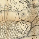
Operations of the Army of the Potomac, May & June 1864.
Scale not given.
Site: American Memory-cultural - Main Catalog Original Format: Map Date: 1864 View catalog record -
Sanborn Fire Insurance Map from Smithton, Westmoreland County, Pennsylvania.
540. 2 Sheet(s). Oct 1925.
Site: American Memory-cultural Original Format: Map Date: 1925-01-01 -
Ownership map of Grapevine area, Tarrant County, Texas. Catalog Record Only
Scale ca. 1:15,000.
Contributor: Latson, W. W. Site: Main Catalog Original Format: Map Date: 1970 -
Hogansville, Georgia, Troup County / Catalog Record Only
1 map ; 26 x 41 cm.
Contributor: Chattahoochee-Flint Area Planning and Development Commission Site: Main Catalog Original Format: Map Date: 1975 -
San Francisco Suisun & San Pablo bays. Catalog Record Only
Relief shown by hachures and spot heights. Depths shown by contours, gradient tints, and soundings.
Contributor: Weekend Outdoor Productions Site: Main Catalog Original Format: Map Date: 1973 -
Dargaville ; Kaitaia ; Kaikohe. Catalog Record Only
Scales vary.
Contributor: Automobile Association (Auckland) Inc Site: Main Catalog Original Format: Map Date: 1978