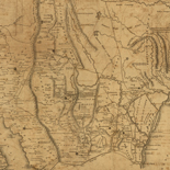
![[Topographical map of part of Washington D.C.].](https://cybercemetery.unt.edu/archive/oilspill/20121227124911im_/http://www.loc.gov/collections/static/civil-war-maps/images/cw0688500.jpg)
![[December 16, 1944], HQ Twelfth Army Group situation map.](https://cybercemetery.unt.edu/archive/oilspill/20121227124911im_/http://www.loc.gov/collections/static/world-war-ii-maps-military-situation-maps-from-1944-to-1945/images/ict21195.jpg)
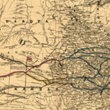
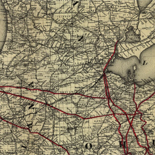
![A correct map of a section of the United States showing the allignment [sic] of the Pittsburgh, Marion, and Chicago Railway between Chewton, Penna. and Marion, Ohio and connections.](https://cybercemetery.unt.edu/archive/oilspill/20121227124911im_/http://www.loc.gov/collections/static/railroad-maps-1828-to-1900/images/rr005350.jpg)
![[Map of Chancellorsville battlefield, May 3-4, 1863].](https://cybercemetery.unt.edu/archive/oilspill/20121227124911im_/http://www.loc.gov/collections/static/hotchkiss-maps/images/cwh00138.jpg)
![Boston its environs and harbour, with the rebels works raised against that town in 1775... Sir Thomas Hyde Page, [1775?].](https://cybercemetery.unt.edu/archive/oilspill/20121227124911im_/http://www.loc.gov/collections/static/american-revolutionary-war-maps/images/ct000070.jpg)
![[Coast of Maine from Frenchmans Bay to Mosquito Harbor].](https://cybercemetery.unt.edu/archive/oilspill/20121227124911im_/http://www.loc.gov/collections/static/american-revolutionary-war-maps/images/np000011.jpg)
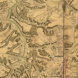
![[Map of parts of Caroline, Hanover, and Henrico counties, Va. west of the Mattaponi River and the Richmond, Fredericksburg, and Potomac Railroad].](https://cybercemetery.unt.edu/archive/oilspill/20121227124911im_/http://www.loc.gov/collections/static/hotchkiss-maps/images/cwh00025.jpg)
Results
-

Town plan maps of Oregon
City maps issued by the Oregon Department of Transportation showing highways, streets, parks, railroads, schools, public buildings, section corners, water features, land features, and various boundaries.
Contributor: Oregon. Dept. of Transportation Site: Finding Aids - Main Catalog Original Format: Map View catalog record -
Herold J. Wiens collection, 1939-1971
Consists of pen and ink drawings, pencil sketches, facsimiles, and photographs of aerial views showing all or part of China during the period of World War II. The collection also consists of ...
Contributor: Wiens, Herold J. (Herold Jacob) - Wiens, Herold J. Site: Finding Aids - Main Catalog Original Format: Map View catalog record -

The Hotchkiss Collection Of Confederate Maps - Hotchkiss Maps
by Clara LeGear Jedediah Hotchkiss was born at Windsor, Broome County, N. Y., November 30, 1828. He was graduated from the Windsor Academy and early showed great interest in botany and in ...
Site: LOC.gov web pages Original Format: Map - Web Page Date: 1948-11-01
Refine your search
Original Format
- Map
- Web Page [1]
Online Format
Contributor
Subject
Language
- English
- Chinese [1]