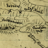
![[Sketch of the Manassas battlefield].](https://cybercemetery.unt.edu/archive/oilspill/20121227125822im_/http://www.loc.gov/collections/static/hotchkiss-maps/images/cwh00108.jpg)
![Boston its environs and harbour, with the rebels works raised against that town in 1775... Sir Thomas Hyde Page, [1775?].](https://cybercemetery.unt.edu/archive/oilspill/20121227125822im_/http://www.loc.gov/collections/static/american-revolutionary-war-maps/images/ct000070.jpg)
![[January 18, 1945], HQ Twelfth Army Group situation map.](https://cybercemetery.unt.edu/archive/oilspill/20121227125822im_/http://www.loc.gov/collections/static/world-war-ii-maps-military-situation-maps-from-1944-to-1945/images/ict21228.jpg)

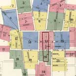
![[Detailed map of part of Virginia from Alexandria to the Potomac River above Washington, D.C. 1886].](https://cybercemetery.unt.edu/archive/oilspill/20121227125822im_/http://www.loc.gov/collections/static/civil-war-maps/images/cw0523000.jpg)
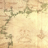
![A map of the most inhabited part of New England... Thomas Jefferys, [London] Thos. Jefferys, 1755.](https://cybercemetery.unt.edu/archive/oilspill/20121227125822im_/http://www.loc.gov/collections/static/american-revolutionary-war-maps/images/ar079700.jpg)

![[Topographical map of part of Washington D.C.].](https://cybercemetery.unt.edu/archive/oilspill/20121227125822im_/http://www.loc.gov/collections/static/civil-war-maps/images/cw0688500.jpg)
![[Map of cavalry engagement near Bridgewater, Va. Oct. 4th and 5th, 1864]](https://cybercemetery.unt.edu/archive/oilspill/20121227125822im_/http://www.loc.gov/collections/static/hotchkiss-maps/images/cwh00193.jpg)
Results
-

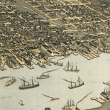
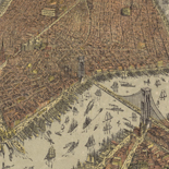
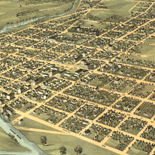
Panoramic Mapping - Panoramic Maps
The tradition of perspective mapping flowered in Europe in the late sixteenth and early seventeenth centuries. Mathias Merian, George Braun, Franz Hogenberg, and others produced perspective maps of European cities. These early ...
Site: LOC.gov web pages Original Format: Map - Web Page Date: 2007-05-17 -

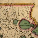
A Question Of Boundaries - Louisiana European Explorations And The Louisiana Purchase
French and American representatives faced a vexing issue when they met in Paris in April 1803 to negotiate a treaty by which the United States would purchase the province of Louisiana from ...
Site: LOC.gov web pages Original Format: Map - Web Page Date: 2007-08-13 -

Overview - World War Ii Maps Military Situation Maps From 1944 To 1945
The World War II Military Situation Maps contains maps showing troop positions beginning on June 6, 1944 to July 26, 1945. Starting with the D-Day Invasion, the maps give daily details on ...
Site: LOC.gov web pages Original Format: Map - Web Page -
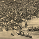
Overview - Panoramic Maps
The panoramic map was a popular cartographic form used to depict U.S. and Canadian cities and towns during the late nineteenth and early twentieth centuries. Known also as bird's-eye views, perspective maps, ...
Contributor: Library of Congress. Geography and Map Division Site: LOC.gov web pages - Main Catalog Original Format: Map - Web Page Date: 2007-05-17 View catalog record -
Louisiana As A French Colony - Louisiana European Explorations And The Louisiana Purchase
Difficult Early Years of the Colony From its inception Louisiana faced an inauspicious existence. Its fate was bound to the French economy during the last years of the reign of Louis XIV. ...
Site: LOC.gov web pages Original Format: Map - Web Page Date: 2007-08-13 -

Exploring the Early Americas Overview
Features selections from the more than 3,000 rare maps, documents, paintings, prints, and artifacts that make up the Jay I. Kislak Collection at the Library of Congress.
Site: LOC.gov web pages Original Format: Book - Three Dimensional Object - Map - Photo, Print, Drawing - Manuscript - Web Page -

History Of Railroads And Maps - Railroad Maps 1828 To 1900
Railways were introduced in England in the seventeenth century as a way to reduce friction in moving heavily loaded wheeled vehicles. The first North American "gravity road," as it was called, was ...
Site: LOC.gov web pages Original Format: Map - Web Page Date: 1998-10-19 -

Maps Of Arcadia National Park - National Parks Maps
Early European Maps | British Maps | Nineteenth Century Nautical Charts | Mount Desert Island | USGS Maps | National Park Service Maps of Acadia Map of the Discovery of the East ...
Site: LOC.gov web pages Original Format: Map - Web Page Date: 1999-06-02 -
Maps Of Great Smoky Mountains National Park - National Parks Maps
Early European Maps | American Maps and Map Makers | Exploration and Geological Mapping | Environmental Maps | Early USGS Maps | USGS and the TVA -- Topographic Quadrangle Maps | National ...
Site: LOC.gov web pages Original Format: Web Page - Map Date: 1999-06-02 -
The Louisiana Purchase - Louisiana European Explorations And The Louisiana Purchase
Napoleonic France Acquires Louisiana On October 1, 1800, within 24 hours of signing a peace settlement with the United States, First Consul of the Republic of France Napoleon Bonaparte, acquired Louisiana from ...
Site: LOC.gov web pages Original Format: Map - Web Page Date: 2007-08-13 -
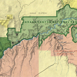
Maps Of Grand Canyon National Park - National Parks Maps
Early European Maps | Old Southwest | Post-Civil War Maps | The Tertiary History | Maps Produced Before 1920 | U.S. Government Maps Detail of [Theodore Roosevelt, head-and-shoulders portrait, facing front], [1904], ...
Site: LOC.gov web pages Original Format: Map - Web Page Date: 1999-06-02 -

Overview - American Revolutionary War Maps
The American Revolution and Its Era: Maps and Charts of North America and the West Indies, 1750-1789 represents an important historical record of the mapping of North America and the Caribbean. Most ...
Site: LOC.gov web pages - Main Catalog Original Format: Map - Web Page Date: 2008-08-04 View catalog record -

Overview - Discovery And Exploration
This category documents the discovery and exploration with both manuscripts and published maps. Many of these maps reflect the European Age of Discoveries, dating from the late 15th century to the 17th ...
Contributor: Library of Congress Geography and Map Division Site: LOC.gov web pages Original Format: Map - Web Page -
The Cartographic Setting - Louisiana European Explorations And The Louisiana Purchase
Evolving European and American Conceptions of Louisiana to 1803 Until 1803 the exploration and mapping of the territory acquired by the United States in the Louisiana Purchase was undertaken by the major ...
Site: LOC.gov web pages Original Format: Map - Web Page Date: 2007-08-13 -

Exploring the Early Americas Home
Explores indigenous cultures, the drama of the encounters between Native Americans and Europeans, and the pivotal changes caused by the meeting of the American and European worlds.
Contributor: Gerard W. Gawalt - James H. Hutson - Pauline Maier - David McCullough - Garry Wills - Gordon Wood - Cokie Roberts - John Hope Franklin Site: LOC.gov web pages Original Format: Book - Three Dimensional Object - Map - Photo, Print, Drawing - Film, Video - Manuscript - Web Page -
Overview - National Parks Maps
The Mapping the National Parks collection documents the history, cultural aspects and geological formations of areas that eventually became National Parks. The collection consists of approximately 200 maps dating from the 17th ...
Site: LOC.gov web pages - Main Catalog Original Format: Map - Web Page Date: 1999-06-02 View catalog record -

Overview - World War Ii Maps Military Situation Maps From 1944 To 1945
The World War II Military Situation Maps contains maps showing troop positions beginning on June 6, 1944 to July 26, 1945. Starting with the D-Day Invasion, the maps give daily details on ...
Site: LOC.gov web pages Original Format: Map - Web Page Date: 1944-01-01 -
Yellowstone The First National Park - National Parks Maps
Among those who played key roles in establishing Yellowstone as the Nation's first national park was Ferdinand Vandiveer Hayden. His accomplishments in 1871-72 were the high point of a long and distinguished ...
Site: LOC.gov web pages Original Format: Map - Web Page Date: 1999-06-02 -
Louisiana As A Spanish Colony - Louisiana European Explorations And The Louisiana Purchase
Diplomacy of the French Cession The impetus to cede the French colony of Louisiana to the Spanish was the long, expensive conflict of the French and Indian War, also known as the ...
Site: LOC.gov web pages Original Format: Map - Web Page Date: 2007-08-13 -
Brief History Of The National Parks - National Parks Maps
Many of America's most scenic and historic places have been set aside for the use of the public as national parks. "National Parks are spacious land . . . areas essentially in ...
Site: LOC.gov web pages Original Format: Map - Web Page Date: 1999-06-02
Refine your search
Original Format
Online Format
- Web Page
- Image [42]
- PDF [1]