Map
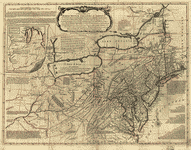
A general map of the middle British colonies in America, viz. Virginia, Maryland, Delaware, Pensilvania, New-Jersey, New York, Connecticut & Rhode-Island: Of Aquanishuonigy the country of the confederate Indians comprehending Aquanishuonigy proper, their places of residence, Ohio & Thuchsochruntie their deer hunting countries, Couchsachrage & Skaniadarade their beaver hunting countries, of the Lakes Erie, Ontario and Champlain. Wherein is also shewn the antient & present seats of the Indian nations.

| Format |
Map |
|---|---|
| Contributors |
Evans, Lewis |
| Dates |
1771 |
| Location |
North America Northeastern States United States |
| Language |
English |
| Subjects |
North America Northeastern States United States |
- Title
- A general map of the middle British colonies in America, viz. Virginia, Maryland, Delaware, Pensilvania, New-Jersey, New York, Connecticut & Rhode-Island: Of Aquanishuonigy the country of the confederate Indians comprehending Aquanishuonigy proper, their places of residence, Ohio & Thuchsochruntie their deer hunting countries, Couchsachrage & Skaniadarade their beaver hunting countries, of the Lakes Erie, Ontario and Champlain. Wherein is also shewn the antient & present seats of the Indian nations.
- Description
-
Scale ca. 1:2,250,000.
-
Hand colored.
-
Relief shown pictorially.
-
Shows "West longitude from London" and "from Philadelphia."
-
LC Maps of North America, 1750-1789, 716
-
Includes text, historical notes, distance charts, and inset of "A sketch of the remaining part of Ohio R. &c."
-
Available also through the Library of Congress Web site as a raster image.
-
col. map ; 49 x 67 cm.
- Creator
- Evans, Lewis,
- Created Published
-
London, Printed for Carington Bowles, 1771.
- Subject Headings
-
-
North America
-
-
Northeastern States
-
-
North America.
-
-
United States--Northeastern States.
- Notes
-
-
Scale ca. 1:2,250,000.
-
-
Hand colored.
-
-
Relief shown pictorially.
-
-
Shows "West longitude from London" and "from Philadelphia."
-
-
LC Maps of North America, 1750-1789, 716
-
-
Includes text, historical notes, distance charts, and inset of "A sketch of the remaining part of Ohio R. &c."
-
-
Available also through the Library of Congress Web site as a raster image.
- Medium
-
col. map ; 49 x 67 cm.
- Call Number
-
G3710 1771 .E8
- Repository
-
Library of Congress Geography and Map Division Washington, D.C. 20540-4650 USA dcu
- Digital Id
-
g3710 ct000081 http://hdl.loc.gov/loc.gmd/g3710.ct000081
- Library of Congress Catalog Number
- 74694156
Rights & Access
The maps in the Map Collections materials were either published prior to 1922, produced by the United States government, or both (see catalogue records that accompany each map for information regarding date of publication and source). The Library of Congress is providing access to these materials for educational and research purposes and is not aware of any U.S. copyright protection (see Title 17 of the United States Code) or any other restrictions in the Map Collection materials.
Note that the written permission of the copyright owners and/or other rights holders (such as publicity and/or privacy rights) is required for distribution, reproduction, or other use of protected items beyond that allowed by fair use or other statutory exemptions. Responsibility for making an independent legal assessment of an item and securing any necessary permissions ultimately rests with persons desiring to use the item.
More about Copyright and other Restrictions
For guidance about compiling full citations consult Citing Primary Sources.
Part of...
More maps like this
-
 A general map of the middle British colonies, in America; viz. Virginia, Mariland, Delaware, Pensilvania, New-Jersey, New-York, Connecticut, and Rhode Island: Of Aquanishuonîgy, the country ...
Contributor:
Evans, Lewis
Site:
American Memory-cultural, Main Catalog
Original Format:
Map
Date:
1755
View catalog record
A general map of the middle British colonies, in America; viz. Virginia, Mariland, Delaware, Pensilvania, New-Jersey, New-York, Connecticut, and Rhode Island: Of Aquanishuonîgy, the country ...
Contributor:
Evans, Lewis
Site:
American Memory-cultural, Main Catalog
Original Format:
Map
Date:
1755
View catalog record
-
 A general map of the middle British colonies in America viz. Virginia, Maryland, Delaware, Pensilvania, New-Jersey, New York, Connecticut & Rhode-Island: Of Aquanishuonigy the country ...
Contributor:
Evans, Lewis
Site:
American Memory-cultural, Main Catalog
Original Format:
Map
Date:
1765
View catalog record
A general map of the middle British colonies in America viz. Virginia, Maryland, Delaware, Pensilvania, New-Jersey, New York, Connecticut & Rhode-Island: Of Aquanishuonigy the country ...
Contributor:
Evans, Lewis
Site:
American Memory-cultural, Main Catalog
Original Format:
Map
Date:
1765
View catalog record
-
 A general map of the middle British colonies in America, viz. Virginia, Maryland, Deleware, Pensilvania, New-Jersey, New York, Connecticut & Rhode Island: Of Aquanishuonigy the ...
Contributor:
Evans, Lewis
Site:
American Memory-cultural, Main Catalog
Original Format:
Map
Date:
1771
View catalog record
A general map of the middle British colonies in America, viz. Virginia, Maryland, Deleware, Pensilvania, New-Jersey, New York, Connecticut & Rhode Island: Of Aquanishuonigy the ...
Contributor:
Evans, Lewis
Site:
American Memory-cultural, Main Catalog
Original Format:
Map
Date:
1771
View catalog record
-
 Pensilvaniæ, Novæ-Cæsareæ, Novi-Eboraci, Aquanishuonigæ et Canadæ,
Contributor:
Evans, Lewis
Site:
American Memory-cultural, Main Catalog
Original Format:
Map
Date:
1784
View catalog record
Pensilvaniæ, Novæ-Cæsareæ, Novi-Eboraci, Aquanishuonigæ et Canadæ,
Contributor:
Evans, Lewis
Site:
American Memory-cultural, Main Catalog
Original Format:
Map
Date:
1784
View catalog record
-
 A general map of the middle British colonies, in America; viz Virginia, Màriland, Dèlaware, Pensilvania, New-Jersey, New-York, Connecticut, and Rhode Island: of Aquanishuonîgy, the country ...
Contributor:
Evans, Lewis
Site:
American Memory-cultural, Main Catalog
Original Format:
Map
Date:
1755
View catalog record
A general map of the middle British colonies, in America; viz Virginia, Màriland, Dèlaware, Pensilvania, New-Jersey, New-York, Connecticut, and Rhode Island: of Aquanishuonîgy, the country ...
Contributor:
Evans, Lewis
Site:
American Memory-cultural, Main Catalog
Original Format:
Map
Date:
1755
View catalog record
-
 A general map of the middle British colonies in America, viz. Virginia, Maryland, Delaware, Pensilvania, New-Jersey, New York, Connecticut & Rhode-Island: Of Aquanishuonigy the country ...
Contributor:
Evans, Lewis
Site:
American Memory-cultural, Main Catalog
Original Format:
Map
Date:
1771
View catalog record
A general map of the middle British colonies in America, viz. Virginia, Maryland, Delaware, Pensilvania, New-Jersey, New York, Connecticut & Rhode-Island: Of Aquanishuonigy the country ...
Contributor:
Evans, Lewis
Site:
American Memory-cultural, Main Catalog
Original Format:
Map
Date:
1771
View catalog record
-
 A general map of the middle British colonies in America, viz. Virginia, Maryland, Delaware, Pensilvania, New-Jersey, New York, Connecticut & Rhode-Island: of Aquanishuonigy the country ...
Contributor:
Evans, Lewis
Site:
American Memory-cultural, Main Catalog
Original Format:
Map
Date:
1771
View catalog record
A general map of the middle British colonies in America, viz. Virginia, Maryland, Delaware, Pensilvania, New-Jersey, New York, Connecticut & Rhode-Island: of Aquanishuonigy the country ...
Contributor:
Evans, Lewis
Site:
American Memory-cultural, Main Catalog
Original Format:
Map
Date:
1771
View catalog record
-
 A general map of the middle British colonies in America, viz. Virginia, Maryland, Delaware, Pensilvania, New-Jersey, New York, Connecticut & Rhode Island: Of Aquanishuonigy the ...
Contributor:
Evans, Lewis
Site:
American Memory-cultural, Main Catalog
Original Format:
Map
Date:
1771
View catalog record
A general map of the middle British colonies in America, viz. Virginia, Maryland, Delaware, Pensilvania, New-Jersey, New York, Connecticut & Rhode Island: Of Aquanishuonigy the ...
Contributor:
Evans, Lewis
Site:
American Memory-cultural, Main Catalog
Original Format:
Map
Date:
1771
View catalog record
-
 A map of Pensilvania, New-Jersey, New-York, and the three Delaware counties.
Contributor:
Evans, Lewis
Site:
American Memory-cultural, Main Catalog
Original Format:
Map
Date:
1752
View catalog record
A map of Pensilvania, New-Jersey, New-York, and the three Delaware counties.
Contributor:
Evans, Lewis
Site:
American Memory-cultural, Main Catalog
Original Format:
Map
Date:
1752
View catalog record
-
 Speciel Land Charte von Pensilvanien, Neu Jersey, Neu York, und von denen drey Land-schafften an dem Delaware Fl. In America in Englischer Spr. gedruckt A. ...
Contributor:
Evans, Lewis
Site:
American Memory-cultural, Main Catalog
Original Format:
Map
Date:
1750
View catalog record
Speciel Land Charte von Pensilvanien, Neu Jersey, Neu York, und von denen drey Land-schafften an dem Delaware Fl. In America in Englischer Spr. gedruckt A. ...
Contributor:
Evans, Lewis
Site:
American Memory-cultural, Main Catalog
Original Format:
Map
Date:
1750
View catalog record
-
 A map of Pensilvania, New-Jersey, New-York, and the three Delaware counties.
Contributor:
Evans, Lewis
Site:
American Memory-cultural, Main Catalog
Original Format:
Map
Date:
1752
View catalog record
A map of Pensilvania, New-Jersey, New-York, and the three Delaware counties.
Contributor:
Evans, Lewis
Site:
American Memory-cultural, Main Catalog
Original Format:
Map
Date:
1752
View catalog record
-
 A map of Pensilvania, New-Jersey, New-York, and the three Delaware counties.
Contributor:
Evans, Lewis
Site:
American Memory-cultural, Main Catalog
Original Format:
Map
Date:
1749
View catalog record
A map of Pensilvania, New-Jersey, New-York, and the three Delaware counties.
Contributor:
Evans, Lewis
Site:
American Memory-cultural, Main Catalog
Original Format:
Map
Date:
1749
View catalog record
-
 A general map of the middle British colonies in America: Viz. Virginia, Maryland, Delaware, Pensilvania, New-Jersey, New-York, Connecticut and Rhode-Island: Of Aquanishuonigy the country of ...
Contributor:
Gibson, J.
Site:
American Memory-cultural, Main Catalog
Original Format:
Map
Date:
1758
View catalog record
A general map of the middle British colonies in America: Viz. Virginia, Maryland, Delaware, Pensilvania, New-Jersey, New-York, Connecticut and Rhode-Island: Of Aquanishuonigy the country of ...
Contributor:
Gibson, J.
Site:
American Memory-cultural, Main Catalog
Original Format:
Map
Date:
1758
View catalog record
-
 Carte du théatre de la guerre actuel entre les Anglais et les Treize Colonies Unies de l'Amerique Septentrionale,
Contributor:
Eliot, J. B.
Site:
American Memory-cultural, Main Catalog
Original Format:
Map
Date:
1778
View catalog record
Carte du théatre de la guerre actuel entre les Anglais et les Treize Colonies Unies de l'Amerique Septentrionale,
Contributor:
Eliot, J. B.
Site:
American Memory-cultural, Main Catalog
Original Format:
Map
Date:
1778
View catalog record
-
 Carte du théatre de la guerre entre les Anglais et les Américains: Dressée d'après les cartes anglaises les plus modernes,
Contributor:
Brion de la Tour, Louis
Site:
American Memory-cultural, Main Catalog
Original Format:
Map
Date:
1777
View catalog record
Carte du théatre de la guerre entre les Anglais et les Américains: Dressée d'après les cartes anglaises les plus modernes,
Contributor:
Brion de la Tour, Louis
Site:
American Memory-cultural, Main Catalog
Original Format:
Map
Date:
1777
View catalog record
You might also like
-

 The archæological collection of the United States National museum,
Contributor:
Rau, Charles
Site:
Main Catalog
Original Format:
Book
Date:
1876
The archæological collection of the United States National museum,
Contributor:
Rau, Charles
Site:
Main Catalog
Original Format:
Book
Date:
1876
-
 Passengers on a Greyhound bus going from Washington, D.C. to Pittsburgh, Pennsylvania
Contributor:
Bubley, Esther
Site:
Prints & Photographs
Original Format:
Photo, Print, Drawing
Date:
1943
Passengers on a Greyhound bus going from Washington, D.C. to Pittsburgh, Pennsylvania
Contributor:
Bubley, Esther
Site:
Prints & Photographs
Original Format:
Photo, Print, Drawing
Date:
1943
-
 A Greyhound bus that has been stopped at a filling station to get water between Washington, D.C. and Pittsburgh, Pennsylvania
Contributor:
Bubley, Esther
Site:
Prints & Photographs
Original Format:
Photo, Print, Drawing
Date:
1943
A Greyhound bus that has been stopped at a filling station to get water between Washington, D.C. and Pittsburgh, Pennsylvania
Contributor:
Bubley, Esther
Site:
Prints & Photographs
Original Format:
Photo, Print, Drawing
Date:
1943
-
 A Greyhound bus that has been stopped while the driver fills the water tank at a gas station on the road between Gettysburg and Pennsylvania
Contributor:
Bubley, Esther
Site:
Prints & Photographs
Original Format:
Photo, Print, Drawing
Date:
1943
A Greyhound bus that has been stopped while the driver fills the water tank at a gas station on the road between Gettysburg and Pennsylvania
Contributor:
Bubley, Esther
Site:
Prints & Photographs
Original Format:
Photo, Print, Drawing
Date:
1943
-
 Two Greyhound buses going from Washington, D.C. to Pittsburgh, Pennsylvania
Contributor:
Bubley, Esther
Site:
Prints & Photographs
Original Format:
Photo, Print, Drawing
Date:
1943
Two Greyhound buses going from Washington, D.C. to Pittsburgh, Pennsylvania
Contributor:
Bubley, Esther
Site:
Prints & Photographs
Original Format:
Photo, Print, Drawing
Date:
1943
-
 Two Greyhound buses on the way to Pittsburgh, Pennsylvania, from Washington, D.C.
Contributor:
Bubley, Esther
Site:
Prints & Photographs
Original Format:
Photo, Print, Drawing
Date:
1943
Two Greyhound buses on the way to Pittsburgh, Pennsylvania, from Washington, D.C.
Contributor:
Bubley, Esther
Site:
Prints & Photographs
Original Format:
Photo, Print, Drawing
Date:
1943