Map
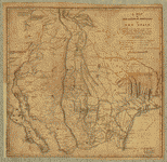
From Fort Smith to the Rio Grande : from explorations and surveys /

| Format |
Map |
|---|---|
| Contributors |
Hoffman, J. D. |
| Dates |
1859 |
| Location |
Southwestern States United States |
| Language |
English |
| Subjects |
Railroads Southwestern States Surveying United States |
- Title
- From Fort Smith to the Rio Grande : from explorations and surveys /
- Description
-
Scale 1:950,400.
-
Relief shown by hachures.
-
At head of title: Route near the 35th Parallel. Map no. 1.
-
From U.S. War Department, Explorations and Surveys for a Railroad Route from the Mississippi River to the Pacific Ocean. Topographical Maps . . . to Illustrate the Various Reports . . . (Washington, 1859)
-
LC Railroad maps, 152
-
Description derived from published bibliography.
-
Inset: Sketch of Rio Pecos at Anton Chico. 20 x 15 cm.
-
Available also through the Library of Congress Web site as a raster image.
-
map 58 x 132 cm.
- Creator
- Hoffman, J. D.
- Created Published
-
[Washington, D.C., 1859]
- Subject Headings
-
-
Railroads--Southwestern States--Surveying
-
-
Southwestern States
-
-
United States--Southwestern States.
- Notes
-
-
Scale 1:950,400.
-
-
Relief shown by hachures.
-
-
At head of title: Route near the 35th Parallel. Map no. 1.
-
-
From U.S. War Department, Explorations and Surveys for a Railroad Route from the Mississippi River to the Pacific Ocean. Topographical Maps . . . to Illustrate the Various Reports . . . (Washington, 1859)
-
-
LC Railroad maps, 152
-
-
Description derived from published bibliography.
-
-
Inset: Sketch of Rio Pecos at Anton Chico. 20 x 15 cm.
-
-
Available also through the Library of Congress Web site as a raster image.
- Medium
-
map 58 x 132 cm.
- Call Number
-
G4296.P3 1854 .H6
- Repository
-
Library of Congress Geography and Map Division Washington, D.C. 20540-4650 USA dcu
- Digital Id
-
g4296p rr001520 http://hdl.loc.gov/loc.gmd/g4296p.rr001520
- Library of Congress Catalog Number
- 98688420
Rights & Access
The maps in the Map Collections materials were either published prior to 1922, produced by the United States government, or both (see catalogue records that accompany each map for information regarding date of publication and source). The Library of Congress is providing access to these materials for educational and research purposes and is not aware of any U.S. copyright protection (see Title 17 of the United States Code) or any other restrictions in the Map Collection materials.
Note that the written permission of the copyright owners and/or other rights holders (such as publicity and/or privacy rights) is required for distribution, reproduction, or other use of protected items beyond that allowed by fair use or other statutory exemptions. Responsibility for making an independent legal assessment of an item and securing any necessary permissions ultimately rests with persons desiring to use the item.
More about Copyright and other Restrictions
For guidance about compiling full citations consult Citing Primary Sources.
Part of...
-
Railroad Maps, 1828 1900
[617]
-
Transportation And Communication Cartographic Items
[761]
-
Geography And Maps Division
[60803]
-
American Memory
[1121009]
More maps like this
-
 From the Rio Grande to the Pacific Ocean : from explorations and surveys /
Contributor:
Hoffman, J. D.
Site:
American Memory-cultural, Main Catalog
Original Format:
Map
Date:
1859
View catalog record
From the Rio Grande to the Pacific Ocean : from explorations and surveys /
Contributor:
Hoffman, J. D.
Site:
American Memory-cultural, Main Catalog
Original Format:
Map
Date:
1859
View catalog record
-
 Sketch showing the route of the New Orleans, Opelousas & Great Western Rail Road, J. G. Gibbes, Chief Engr., lithographie [sic] agent D. Theuret, Exange ...
Contributor:
Okelomski, F. A.
Site:
American Memory-cultural, Main Catalog
Original Format:
Map
Date:
1853
View catalog record
Sketch showing the route of the New Orleans, Opelousas & Great Western Rail Road, J. G. Gibbes, Chief Engr., lithographie [sic] agent D. Theuret, Exange ...
Contributor:
Okelomski, F. A.
Site:
American Memory-cultural, Main Catalog
Original Format:
Map
Date:
1853
View catalog record
-
 A map of the Internal Provinces of New Spain.
Contributor:
Pike, Zebulon Montgomery
Site:
American Memory-cultural, Main Catalog
Original Format:
Map
Date:
1807
View catalog record
A map of the Internal Provinces of New Spain.
Contributor:
Pike, Zebulon Montgomery
Site:
American Memory-cultural, Main Catalog
Original Format:
Map
Date:
1807
View catalog record
-
 Map exhibiting that portion of the State of Pennsylvania traversed by the surveys for a continuous rail road from Harrisburg to Pittsburg made under the ...
Contributor:
Cramer, Charles
Site:
American Memory-cultural, Main Catalog
Original Format:
Map
Date:
1840
View catalog record
Map exhibiting that portion of the State of Pennsylvania traversed by the surveys for a continuous rail road from Harrisburg to Pittsburg made under the ...
Contributor:
Cramer, Charles
Site:
American Memory-cultural, Main Catalog
Original Format:
Map
Date:
1840
View catalog record
-
 Map and profile of the Cañada de las Uvas : from explorations and surveys /
Contributor:
Williamson, R. S.
Site:
American Memory-cultural, Main Catalog
Original Format:
Map
Date:
1859
View catalog record
Map and profile of the Cañada de las Uvas : from explorations and surveys /
Contributor:
Williamson, R. S.
Site:
American Memory-cultural, Main Catalog
Original Format:
Map
Date:
1859
View catalog record
-
 Map of passes in the Sierra Nevada from Walker's Pass to the Coast Range : from explorations and surveys /
Contributor:
Williamson, R. S.
Site:
American Memory-cultural, Main Catalog
Original Format:
Map
Date:
1859
View catalog record
Map of passes in the Sierra Nevada from Walker's Pass to the Coast Range : from explorations and surveys /
Contributor:
Williamson, R. S.
Site:
American Memory-cultural, Main Catalog
Original Format:
Map
Date:
1859
View catalog record
-
 Rocky Mountains to Puget Sound : from explorations and surveys /
Contributor:
Lambert, John
Site:
American Memory-cultural, Main Catalog
Original Format:
Map
Date:
1859
View catalog record
Rocky Mountains to Puget Sound : from explorations and surveys /
Contributor:
Lambert, John
Site:
American Memory-cultural, Main Catalog
Original Format:
Map
Date:
1859
View catalog record
-
 General map of explorations and surveys in California /
Contributor:
Williamson, R. S.
Site:
American Memory-cultural, Main Catalog
Original Format:
Map
Date:
1859
View catalog record
General map of explorations and surveys in California /
Contributor:
Williamson, R. S.
Site:
American Memory-cultural, Main Catalog
Original Format:
Map
Date:
1859
View catalog record
-
 Map of the route surveyed from the Mississippi at Lake Providence in Louisiana to the great bend of Red river at Fulton in Arkansas /
Contributor:
Sidell, William Henry
Site:
American Memory-cultural, Main Catalog
Original Format:
Map
Date:
1850
View catalog record
Map of the route surveyed from the Mississippi at Lake Providence in Louisiana to the great bend of Red river at Fulton in Arkansas /
Contributor:
Sidell, William Henry
Site:
American Memory-cultural, Main Catalog
Original Format:
Map
Date:
1850
View catalog record
-
 St. Paul to Riviere des Lacs : from explorations and surveys /
Contributor:
Lambert, John
Site:
American Memory-cultural, Main Catalog
Original Format:
Map
Date:
1859
View catalog record
St. Paul to Riviere des Lacs : from explorations and surveys /
Contributor:
Lambert, John
Site:
American Memory-cultural, Main Catalog
Original Format:
Map
Date:
1859
View catalog record
-
 From San Francisco Bay to the northern boundary of California : from explorations and surveys /
Contributor:
Williamson, R. S.
Site:
American Memory-cultural, Main Catalog
Original Format:
Map
Date:
1859
View catalog record
From San Francisco Bay to the northern boundary of California : from explorations and surveys /
Contributor:
Williamson, R. S.
Site:
American Memory-cultural, Main Catalog
Original Format:
Map
Date:
1859
View catalog record
-
 From San Francisco Bay to the Plains of Los Angeles : from explorations and surveys /
Contributor:
Custer, H.
Site:
American Memory-cultural, Main Catalog
Original Format:
Map
Date:
1859
View catalog record
From San Francisco Bay to the Plains of Los Angeles : from explorations and surveys /
Contributor:
Custer, H.
Site:
American Memory-cultural, Main Catalog
Original Format:
Map
Date:
1859
View catalog record
-
 Explorations and surveys for a rail road route from the Mississippi River to the Pacific Ocean. Route near the 38th & 39th parallels.
Contributor:
Egloffstein, F. W.
Site:
American Memory-cultural, Main Catalog
Original Format:
Map
Date:
1859
View catalog record
Explorations and surveys for a rail road route from the Mississippi River to the Pacific Ocean. Route near the 38th & 39th parallels.
Contributor:
Egloffstein, F. W.
Site:
American Memory-cultural, Main Catalog
Original Format:
Map
Date:
1859
View catalog record
-
 Riviere des Lacs to the Rocky Mountains : from explorations and surveys /
Contributor:
Lambert, John
Site:
American Memory-cultural, Main Catalog
Original Format:
Map
Date:
1859
View catalog record
Riviere des Lacs to the Rocky Mountains : from explorations and surveys /
Contributor:
Lambert, John
Site:
American Memory-cultural, Main Catalog
Original Format:
Map
Date:
1859
View catalog record
-
 Map and profile of the Tejon Pass : from explorations and surveys /
Contributor:
Williamson, R. S.
Site:
American Memory-cultural, Main Catalog
Original Format:
Map
Date:
1859
View catalog record
Map and profile of the Tejon Pass : from explorations and surveys /
Contributor:
Williamson, R. S.
Site:
American Memory-cultural, Main Catalog
Original Format:
Map
Date:
1859
View catalog record
-
 Skeleton map exhibiting the route explored by Capt. J. W. Gunnison U.S.A., 38 parallel of north latitude (1853), also that of the 41 parallel of ...
Contributor:
Egloffstein, F. W.
Site:
American Memory-cultural, Main Catalog
Original Format:
Map
Date:
1855
View catalog record
Skeleton map exhibiting the route explored by Capt. J. W. Gunnison U.S.A., 38 parallel of north latitude (1853), also that of the 41 parallel of ...
Contributor:
Egloffstein, F. W.
Site:
American Memory-cultural, Main Catalog
Original Format:
Map
Date:
1855
View catalog record
You might also like
-
 Conductor working on his records in the caboose enroute to Canadian, Texas
Contributor:
Delano, Jack
Site:
Prints & Photographs
Original Format:
Photo, Print, Drawing
Date:
1943
Conductor working on his records in the caboose enroute to Canadian, Texas
Contributor:
Delano, Jack
Site:
Prints & Photographs
Original Format:
Photo, Print, Drawing
Date:
1943
-
 General view of part of an Atchison, Topeka and Santa Fe Railroad yard
Contributor:
Delano, Jack
Site:
Prints & Photographs
Original Format:
Photo, Print, Drawing
Date:
1943
General view of part of an Atchison, Topeka and Santa Fe Railroad yard
Contributor:
Delano, Jack
Site:
Prints & Photographs
Original Format:
Photo, Print, Drawing
Date:
1943
-
 Making up trains in an Atchison, Topeka and Santa Fe Railroad yard
Contributor:
Delano, Jack
Site:
Prints & Photographs
Original Format:
Photo, Print, Drawing
Date:
1943
Making up trains in an Atchison, Topeka and Santa Fe Railroad yard
Contributor:
Delano, Jack
Site:
Prints & Photographs
Original Format:
Photo, Print, Drawing
Date:
1943
-
 General view of a Atchison, Topeka and Santa Fe Railroad yard
Contributor:
Delano, Jack
Site:
Prints & Photographs
Original Format:
Photo, Print, Drawing
Date:
1943
General view of a Atchison, Topeka and Santa Fe Railroad yard
Contributor:
Delano, Jack
Site:
Prints & Photographs
Original Format:
Photo, Print, Drawing
Date:
1943
-
 Sandstorm over a Atchison, Topeka and Santa Fe Railroad yard
Contributor:
Delano, Jack
Site:
Prints & Photographs
Original Format:
Photo, Print, Drawing
Date:
1943
Sandstorm over a Atchison, Topeka and Santa Fe Railroad yard
Contributor:
Delano, Jack
Site:
Prints & Photographs
Original Format:
Photo, Print, Drawing
Date:
1943