![[December 25, 1944], HQ Twelfth Army Group situation map.](https://cybercemetery.unt.edu/archive/oilspill/20121228145153im_/http://www.loc.gov/collections/static/world-war-ii-maps-military-situation-maps-from-1944-to-1945/images/ict21204.jpg)

![A correct map of a section of the United States showing the allignment [sic] of the Pittsburgh, Marion, and Chicago Railway between Chewton, Penna. and Marion, Ohio and connections.](https://cybercemetery.unt.edu/archive/oilspill/20121228145153im_/http://www.loc.gov/collections/static/railroad-maps-1828-to-1900/images/rr005350.jpg)
![A map of the most inhabited part of New England... Thomas Jefferys, [London] Thos. Jefferys, 1755.](https://cybercemetery.unt.edu/archive/oilspill/20121228145153im_/http://www.loc.gov/collections/static/american-revolutionary-war-maps/images/ar079700.jpg)
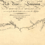
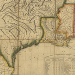
![Carte particulière d'une partie de la Louisianne ou les fleuve et rivierres [i.e. rivières] onts etés relevé a l'estime & les routtes [i.e. routes] par terre relevé & mesurées aux pas, par les Srs. Broutin, de Vergés, ingénieurs & Saucier dessinateur](https://cybercemetery.unt.edu/archive/oilspill/20121228145153im_/http://www.loc.gov/collections/static/louisiana-european-explorations-and-the-louisiana-purchase/images/ct000681.jpg)

Results
-

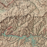
Gettysburg battlefield
Scale ca. 1:26,000.
Contributor: Cope, Emmor B. Site: American Memory-cultural - Main Catalog Original Format: Map Date: 1863 View catalog record -

The battle of Gettysburg, revised 1951, February 1948. /
Relief shown by hachures.
Contributor: United States. National Park Service Site: American Memory-cultural - Main Catalog Original Format: Map Date: 1959 View catalog record -

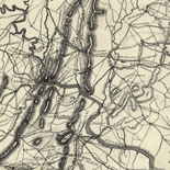
[Preliminary sketch of the battle of Gettysburg showing troop positions, July 2, 1863].
Shows names of some residents.
Site: American Memory-cultural - Main Catalog Original Format: Map Date: 1863-07-02 View catalog record -

Map of the Battle of Gettysburg showing positions held July 1st & 3rd 1863.
Color coding indicates the location of Union and Confederate forces.
Contributor: Sneden, Robert Knox Site: American Memory-cultural Original Format: Map Date: 1861 -

Perspective view of Gettysburg National Military Park
Scale not given.
Contributor: Cope, Emmor B. Site: American Memory-cultural - Main Catalog Original Format: Map Date: 1916 View catalog record -

Map of the battle field of Gettysburg, July 1st, 2nd, 3rd 1863 /
"The map is reduced from one on a scale of 200 feet to the inch, deposited in the Archives of the office of the Chief of Engineers. The survey was ordered by ...
Contributor: Bachelder, John B. Site: American Memory-cultural Original Format: Map Date: 1959 -

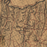
Map shewing [sic] movements of army from 30th June to 1st July 1863 : and first encounter of 1st Corps with the enemy.
Color coding indicates the location of Union and Confederate forces.
Contributor: Sneden, Robert Knox Site: American Memory-cultural Original Format: Map Date: 1861 -

Gettysburg and vicinity, showing the position of the troops July 3, 1863 (third day's fight), and the land purchased and dedicated to the public by ...
Scale ca. 1:15,840.
Contributor: Gettysburg Battlefield Memorial Association Site: American Memory-cultural - Main Catalog Original Format: Map Date: 1863-07-03 View catalog record -

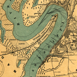
Gettysburg and vicinity : showing the lines of battle, July, 1863, and the land purchased and dedicated to the public by General S. Wylie Crawford ...
Shows Union positions in blue and Confederate positions in red, roads, houses and names of residents, fences, railroad, vegetation, and drainage.
Contributor: Long, James T. Site: American Memory-cultural - Main Catalog Original Format: Map Date: 1863 View catalog record -

The Battle of Gettysburg Penna. Showing positions held July 2nd, 1863.
Color coding indicates the location of Union and Confederate forces.
Contributor: Sneden, Robert Knox Site: American Memory-cultural Original Format: Map Date: 1863 -

Gettysburg battle-field. Battle fought at Gettysburg, Pa., July 1st, 2d & 3d, 1863 by the Federal and Confederate armies, commanded respectively by Genl. G. G. ...
Scale not given.
Contributor: Bachelder, John B. Site: American Memory-cultural - Main Catalog Original Format: Map Date: 1863 View catalog record -

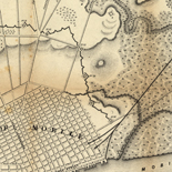
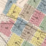
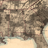
Map of Adams Co., Pennsylvania /
Exhibition: Maps for an Emerging Nation: Commercial Cartography in Nineteenth-century America, Aug. 8-Oct. 20, 1977, DLC
Contributor: Hopkins, Griffith Morgan Site: American Memory-cultural - Main Catalog Original Format: Map Date: 1858 View catalog record -

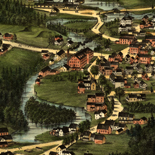
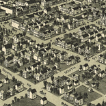
Gettysburg, Pennsylvania 1888.
Perspective map not drawn to scale.
Contributor: Fowler, T. M. Site: American Memory-cultural - Main Catalog Original Format: Map Date: 1888 View catalog record -

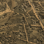
Birds-eye view of the battlefield of Gettysburg.
"Copyright Jan. 18, 1901. C 476 H" in pencil in lower margin. DLC
Contributor: Gettysburg National Military Park Commission Site: American Memory-cultural - Main Catalog Original Format: Map Date: 1901 View catalog record -

[Preliminary sketch of the battle of Gettysburg showing troop positions, July 2, 1863].
Shows names of some residents.
Site: American Memory-cultural - Main Catalog Original Format: Map Date: 1863-07-02 View catalog record -
Map of the battlefield of Gettysburg from original surveys by the engineers of the Commission.
Scale ca. 1:8,350.
Contributor: Gettysburg National Military Park Commission Site: American Memory-cultural - Main Catalog Original Format: Map Date: 1914 View catalog record -

Battle of Gettysburg, July 1, 1863. First day. General position of troops, 2 to 3.30 p.m.
Scale 1:23,400 (1950 feet to the inch).
Site: American Memory-cultural - Main Catalog Original Format: Map Date: 1863-07-01 View catalog record -

Position of Union and Confederate armies on the morning of July 1, 1863.
Scale 1:633,600 (10 miles to 1 inch).
Site: American Memory-cultural - Main Catalog Original Format: Map Date: 1863-07-01 View catalog record -

Map showing the positions occupied by the Third Pennsylvania Cavalry in the engagements on the right flank at Gettysburg, Pa., between the Union cavalry under ...
Scale ca. 1:24,200.
Contributor: United States. Army. Pennsylvania Cavalry Regiment, 3rd Site: American Memory-cultural - Main Catalog Original Format: Map Date: 1863 View catalog record -

[Sketch of the battlefield of Gettysburg, July 1st and 2nd, 1863].
Shows troop movements and names of some residents.
Site: American Memory-cultural - Main Catalog Original Format: Map Date: 1863 View catalog record
Refine your search
Original Format
- Map
Online Format
- Image
Site
- American Memory-cultural
- Main Catalog [56]