Map
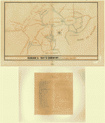
Hudson's Bay's country /
Views

More Views
| Format |
Map |
|---|---|
| Contributors |
Kohl, J. G. |
| Dates |
1850 |
| Location |
Canada United States |
| Language |
English |
| Subjects |
Canada United States |
- Title
- Hudson's Bay's country /
- Description
-
Also covers northern United States.
-
Relief shown pictorially.
-
Copy of a manuscript map from the the Archives of the Hudson's Bay Company.
-
Pen-and-ink and watercolor.
-
Available also through the Library of Congress Web site as a raster image.
-
1 map : ms., col. ; 44 x 62 cm. + text ([1] leaf : ms. ; 41 x 36 cm.)
- Creator
- Kohl, J. G.
- Created Published
-
[ca. 1850]
- Subject Headings
-
-
Canada
-
-
United States
-
-
Canada.
-
-
United States.
- Notes
-
-
Also covers northern United States.
-
-
Relief shown pictorially.
-
-
Copy of a manuscript map from the the Archives of the Hudson's Bay Company.
-
-
Pen-and-ink and watercolor.
-
-
Available also through the Library of Congress Web site as a raster image.
- Medium
-
1 map : ms., col. ; 44 x 62 cm. + text ([1] leaf : ms. ; 41 x 36 cm.)
- Call Number
-
G3400 1785 .K6
- Repository
-
Library of Congress Geography and Map Division Washington, D.C. 20540-4650 USA dcu
- Digital Id
-
g3400 ct000680r http://hdl.loc.gov/loc.gmd/g3400.ct000680r
-
g3400 ct000680r http://hdl.loc.gov/loc.gmd/g3400.ct000680v
- Library of Congress Catalog Number
- 2002622133
Rights & Access
The maps in the Map Collections materials were either published prior to 1922, produced by the United States government, or both (see catalogue records that accompany each map for information regarding date of publication and source). The Library of Congress is providing access to these materials for educational and research purposes and is not aware of any U.S. copyright protection (see Title 17 of the United States Code) or any other restrictions in the Map Collection materials.
Note that the written permission of the copyright owners and/or other rights holders (such as publicity and/or privacy rights) is required for distribution, reproduction, or other use of protected items beyond that allowed by fair use or other statutory exemptions. Responsibility for making an independent legal assessment of an item and securing any necessary permissions ultimately rests with persons desiring to use the item.
More about Copyright and other Restrictions
For guidance about compiling full citations consult Citing Primary Sources.
Part of...
-
Louisiana: European Explorations And The Louisiana Purchase
[77]
-
Discovery And Exploration
[150]
-
Geography And Maps Division
[60803]
-
American Memory
[1121009]
More maps like this
-
 Map of the discovery of the ...
Contributor:
Kohl, J. G.
Site:
American Memory-cultural, Main Catalog
Original Format:
Map
Date:
1856
View catalog record
Map of the discovery of the ...
Contributor:
Kohl, J. G.
Site:
American Memory-cultural, Main Catalog
Original Format:
Map
Date:
1856
View catalog record
-
 An Indian map of the Upper-Missouri, 1801.
Contributor:
Kohl, J. G.
Site:
American Memory-cultural, Main Catalog
Original Format:
Map
Date:
1850
View catalog record
An Indian map of the Upper-Missouri, 1801.
Contributor:
Kohl, J. G.
Site:
American Memory-cultural, Main Catalog
Original Format:
Map
Date:
1850
View catalog record
-
 The upper Mississippi and Missouri /
Contributor:
Kohl, J. G.
Site:
American Memory-cultural, Main Catalog
Original Format:
Map
Date:
1850
View catalog record
The upper Mississippi and Missouri /
Contributor:
Kohl, J. G.
Site:
American Memory-cultural, Main Catalog
Original Format:
Map
Date:
1850
View catalog record
-
 Map of America by Diego Ribero 1529.
Contributor:
Kohl, J. G.
Site:
American Memory-cultural, Main Catalog
Original Format:
Map
Date:
1840
View catalog record
Map of America by Diego Ribero 1529.
Contributor:
Kohl, J. G.
Site:
American Memory-cultural, Main Catalog
Original Format:
Map
Date:
1840
View catalog record
-
 The universe after Cosmas, [A.D.] 550.
Contributor:
Kohl, J. G.
Site:
American Memory-cultural, Main Catalog
Original Format:
Map
Date:
1860
View catalog record
The universe after Cosmas, [A.D.] 550.
Contributor:
Kohl, J. G.
Site:
American Memory-cultural, Main Catalog
Original Format:
Map
Date:
1860
View catalog record
-
 Hudson's Bay's country after La Veranderie, about 1740.
Contributor:
Kohl, J. G.
Site:
American Memory-cultural, Main Catalog
Original Format:
Map
Date:
1850
View catalog record
Hudson's Bay's country after La Veranderie, about 1740.
Contributor:
Kohl, J. G.
Site:
American Memory-cultural, Main Catalog
Original Format:
Map
Date:
1850
View catalog record
-
 Carte du Canada et des Etats-Unis de l'Amérique Septentrionale /
Contributor:
Robert de Vaugondy, Gilles
Site:
American Memory-cultural, Main Catalog
Original Format:
Map
Date:
1778
View catalog record
Carte du Canada et des Etats-Unis de l'Amérique Septentrionale /
Contributor:
Robert de Vaugondy, Gilles
Site:
American Memory-cultural, Main Catalog
Original Format:
Map
Date:
1778
View catalog record
-
 Bowles's new pocket map of the United States of America; the British possessions of Canada, Nova Scotia, and Newfoundland, with the French and Spanish territories ...
Contributor:
Bowles, Carington
Site:
American Memory-cultural, Main Catalog
Original Format:
Map
Date:
1783
View catalog record
Bowles's new pocket map of the United States of America; the British possessions of Canada, Nova Scotia, and Newfoundland, with the French and Spanish territories ...
Contributor:
Bowles, Carington
Site:
American Memory-cultural, Main Catalog
Original Format:
Map
Date:
1783
View catalog record
-
 A map of Canada and the north part of Louisiana with the adjacent countrys.
Contributor:
Jefferys, Thomas
Site:
American Memory-cultural, Main Catalog
Original Format:
Map
Date:
1768
View catalog record
A map of Canada and the north part of Louisiana with the adjacent countrys.
Contributor:
Jefferys, Thomas
Site:
American Memory-cultural, Main Catalog
Original Format:
Map
Date:
1768
View catalog record
-
 [Etats-Unie: Partie septentrionale].
Site:
American Memory-cultural, Main Catalog
Original Format:
Map
Date:
1708
View catalog record
[Etats-Unie: Partie septentrionale].
Site:
American Memory-cultural, Main Catalog
Original Format:
Map
Date:
1708
View catalog record
-
 Rand McNally new official railroad map of the United States and southern Canada.
Contributor:
Rand McNally and Company
Site:
American Memory-cultural, Main Catalog
Original Format:
Map
Date:
1920
View catalog record
Rand McNally new official railroad map of the United States and southern Canada.
Contributor:
Rand McNally and Company
Site:
American Memory-cultural, Main Catalog
Original Format:
Map
Date:
1920
View catalog record
-
 Canadian Pacific Railway and connecting lines /
Contributor:
Canadian Pacific Railway Company
Site:
American Memory-cultural, Main Catalog
Original Format:
Map
Date:
1912
View catalog record
Canadian Pacific Railway and connecting lines /
Contributor:
Canadian Pacific Railway Company
Site:
American Memory-cultural, Main Catalog
Original Format:
Map
Date:
1912
View catalog record
-
 Pensilvaniæ, Novæ-Cæsareæ, Novi-Eboraci, Aquanishuonigæ et Canadæ,
Contributor:
Evans, Lewis
Site:
American Memory-cultural, Main Catalog
Original Format:
Map
Date:
1784
View catalog record
Pensilvaniæ, Novæ-Cæsareæ, Novi-Eboraci, Aquanishuonigæ et Canadæ,
Contributor:
Evans, Lewis
Site:
American Memory-cultural, Main Catalog
Original Format:
Map
Date:
1784
View catalog record
-
 Carte des pays connus sous le nom de Canada, dans laquelle sont distinguées les possessions françoises, & angl?
Contributor:
Robert de Vaugondy, Didier
Site:
American Memory-cultural, Main Catalog
Original Format:
Map
Date:
1753
View catalog record
Carte des pays connus sous le nom de Canada, dans laquelle sont distinguées les possessions françoises, & angl?
Contributor:
Robert de Vaugondy, Didier
Site:
American Memory-cultural, Main Catalog
Original Format:
Map
Date:
1753
View catalog record
-
 A map of Canada and the north part of Louisiana with the adjacent countrys.
Contributor:
Jefferys, Thomas
Site:
American Memory-cultural, Main Catalog
Original Format:
Map
Date:
1768
View catalog record
A map of Canada and the north part of Louisiana with the adjacent countrys.
Contributor:
Jefferys, Thomas
Site:
American Memory-cultural, Main Catalog
Original Format:
Map
Date:
1768
View catalog record
-
 Color image map : [ports of entry, United States-Canadian border] /
Contributor:
Geological Survey (U.S.)
Site:
American Memory-cultural, Main Catalog
Original Format:
Map
Date:
1978
View catalog record
Color image map : [ports of entry, United States-Canadian border] /
Contributor:
Geological Survey (U.S.)
Site:
American Memory-cultural, Main Catalog
Original Format:
Map
Date:
1978
View catalog record
You might also like
-

 The boundary line between the British provinces and the United States.
Contributor:
Bird, William A.
Site:
Main Catalog
Original Format:
Book
Date:
1864
The boundary line between the British provinces and the United States.
Contributor:
Bird, William A.
Site:
Main Catalog
Original Format:
Book
Date:
1864
-
-
-
-
Appletons' hand-book of American travel. Northern and eastern tour. Including New York, New Jersey, Pennsylvania, Connecticut, Rhode Island, Massachusetts, Maine, New Hampshire, Vermont, and the ...
Site:
Main Catalog
Original Format:
Book
Date:
1872
-