Map
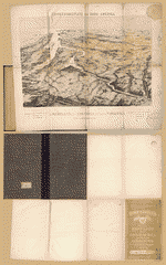
Part of map of portions of the milit'y dep'ts of Washington, Pennsylvania, Annapolis, and north eastern Virginia /

| Format |
Map |
|---|---|
| Contributors |
United States. Topographical Bureau |
| Dates |
1861 |
| Location |
Maryland United States Virginia Washington Washington D.C. Washington Region |
| Language |
English |
| Subjects |
District of Columbia Maryland United States Virginia Washington Washington Region |
- Title
- Part of map of portions of the milit'y dep'ts of Washington, Pennsylvania, Annapolis, and north eastern Virginia /
- Description
-
Relief shown by shading.
-
Shows Washington D.C. region, including western part of Maryland and northeastern Virginia. Does not show Pennsylvania with the exception of Gettysburg.
-
Probable Confederate copy of Bureau of Topographical Engineers original.
-
Pen-and-ink with some annotations in pencil, on 2 sheets pasted together and mounted on cloth.
-
LC Civil War maps (2nd ed.), H13
-
Available also through the Library of Congress web site as raster image.
-
Imperfect: losses on the upper and lower left edges.
-
1 map : col. ms. ; 56 x 85 cm.
- Creator
- United States. Topographical Bureau.
- Subject Headings
-
-
Washington Region
-
-
Maryland
-
-
Virginia
-
-
United States--District of Columbia--Washington.
-
-
United States--Virginia.
-
-
United States--Maryland.
- Notes
-
-
Relief shown by shading.
-
-
Shows Washington D.C. region, including western part of Maryland and northeastern Virginia. Does not show Pennsylvania with the exception of Gettysburg.
-
-
Probable Confederate copy of Bureau of Topographical Engineers original.
-
-
Pen-and-ink with some annotations in pencil, on 2 sheets pasted together and mounted on cloth.
-
-
LC Civil War maps (2nd ed.), H13
-
-
Available also through the Library of Congress web site as raster image.
-
-
Imperfect: losses on the upper and lower left edges.
- Medium
-
1 map : col. ms. ; 56 x 85 cm.
- Call Number
-
G3850 1861 .U55
- Repository
-
Library of Congress Geography and Map Division Washington, D.C. 20540-4650 dcu
- Digital Id
-
g3850 cwh00013 http://hdl.loc.gov/loc.gmd/g3850.cwh00013
- Library of Congress Catalog Number
- 2002627436
Rights & Access
The maps in the Map Collections materials were either published prior to 1922, produced by the United States government, or both (see catalogue records that accompany each map for information regarding date of publication and source). The Library of Congress is providing access to these materials for educational and research purposes and is not aware of any U.S. copyright protection (see Title 17 of the United States Code) or any other restrictions in the Map Collection materials.
Note that the written permission of the copyright owners and/or other rights holders (such as publicity and/or privacy rights) is required for distribution, reproduction, or other use of protected items beyond that allowed by fair use or other statutory exemptions. Responsibility for making an independent legal assessment of an item and securing any necessary permissions ultimately rests with persons desiring to use the item.
More about Copyright and other Restrictions
For guidance about compiling full citations consult Citing Primary Sources.
Part of...
-
Hotchkiss Map Collection
[345]
-
Civil War Maps
[2281]
-
Military Battles And Campaigns Cartographic Items
[3867]
-
Geography And Maps Division
[60803]
-
American Memory
[1121009]
More maps like this
-
 Part of map of portions of the milit'y dept's of Washington, Pennsylvania, Annapolis, and north eastern Virginia /
Contributor:
United States. Topographical Bureau
Site:
American Memory-cultural, Main Catalog
Original Format:
Map
Date:
1864
View catalog record
Part of map of portions of the milit'y dept's of Washington, Pennsylvania, Annapolis, and north eastern Virginia /
Contributor:
United States. Topographical Bureau
Site:
American Memory-cultural, Main Catalog
Original Format:
Map
Date:
1864
View catalog record
-
 Part of map of portions of the mility. dep'ts of Washington, Pennsylvania, Annapolis, and north eastern Virginia /
Contributor:
United States. Topographical Bureau
Site:
American Memory-cultural, Main Catalog
Original Format:
Map
Date:
1862
View catalog record
Part of map of portions of the mility. dep'ts of Washington, Pennsylvania, Annapolis, and north eastern Virginia /
Contributor:
United States. Topographical Bureau
Site:
American Memory-cultural, Main Catalog
Original Format:
Map
Date:
1862
View catalog record
-
 Part of map of portions of the mility. dep'ts of Washington, Pennsylvania, Annapolis, and north eastern Virginia. Compiled in the Bureau of Topographical Engr. War ...
Contributor:
United States. Topographical Bureau
Site:
American Memory-cultural, Main Catalog
Original Format:
Map
Date:
1861
View catalog record
Part of map of portions of the mility. dep'ts of Washington, Pennsylvania, Annapolis, and north eastern Virginia. Compiled in the Bureau of Topographical Engr. War ...
Contributor:
United States. Topographical Bureau
Site:
American Memory-cultural, Main Catalog
Original Format:
Map
Date:
1861
View catalog record
-
 Part of Washington County, Md. /
Contributor:
United States. Topographical Bureau
Site:
American Memory-cultural
Original Format:
Map
Date:
1862
Part of Washington County, Md. /
Contributor:
United States. Topographical Bureau
Site:
American Memory-cultural
Original Format:
Map
Date:
1862
-
 [Map of northern Virginia and part of Maryland].
Site:
American Memory-cultural, Main Catalog
Original Format:
Map
Date:
1862
View catalog record
[Map of northern Virginia and part of Maryland].
Site:
American Memory-cultural, Main Catalog
Original Format:
Map
Date:
1862
View catalog record
-
 [Map of portions of Virginia and Maryland, extending from Baltimore to Strasburg, and from Washington to Gettysburg, with concentric circles at 5-mile intervals centering on ...
Site:
American Memory-cultural, Main Catalog
Original Format:
Map
View catalog record
[Map of portions of Virginia and Maryland, extending from Baltimore to Strasburg, and from Washington to Gettysburg, with concentric circles at 5-mile intervals centering on ...
Site:
American Memory-cultural, Main Catalog
Original Format:
Map
View catalog record
-
 Kriegsschauplatz von Nord-America. Theil von Maryland, Distr. Columbia und Theil von Virginien /
Contributor:
Verlag von A.D. Geisler
Site:
American Memory-cultural, Main Catalog
Original Format:
Map
Date:
1862
View catalog record
Kriegsschauplatz von Nord-America. Theil von Maryland, Distr. Columbia und Theil von Virginien /
Contributor:
Verlag von A.D. Geisler
Site:
American Memory-cultural, Main Catalog
Original Format:
Map
Date:
1862
View catalog record
-
 District of Columbia and the seat of war on the Potomac.
Contributor:
Bohn, Casimir
Site:
American Memory-cultural, Main Catalog
Original Format:
Map
Date:
1861
View catalog record
District of Columbia and the seat of war on the Potomac.
Contributor:
Bohn, Casimir
Site:
American Memory-cultural, Main Catalog
Original Format:
Map
Date:
1861
View catalog record
-
 [A map of Fairfax County, and parts of Loudoun and Prince William Counties, Va., and the District of Columbia] /
Contributor:
Hoffmann, J. Paul
Site:
American Memory-cultural, Main Catalog
Original Format:
Map
Date:
1864
View catalog record
[A map of Fairfax County, and parts of Loudoun and Prince William Counties, Va., and the District of Columbia] /
Contributor:
Hoffmann, J. Paul
Site:
American Memory-cultural, Main Catalog
Original Format:
Map
Date:
1864
View catalog record
-
 Distance maps. Map of the Atlantic states, showing 50 mile distances from Washington. Map of the battleground [at Manassas] showing 5 mile distances from Washington. ...
Contributor:
Louis Prang and Company
Site:
American Memory-cultural, Main Catalog
Original Format:
Map
Date:
1861
View catalog record
Distance maps. Map of the Atlantic states, showing 50 mile distances from Washington. Map of the battleground [at Manassas] showing 5 mile distances from Washington. ...
Contributor:
Louis Prang and Company
Site:
American Memory-cultural, Main Catalog
Original Format:
Map
Date:
1861
View catalog record
-
 Map of the seat of war!
Contributor:
Louis Prang and Company
Site:
American Memory-cultural, Main Catalog
Original Format:
Map
Date:
1861
View catalog record
Map of the seat of war!
Contributor:
Louis Prang and Company
Site:
American Memory-cultural, Main Catalog
Original Format:
Map
Date:
1861
View catalog record
-
 Map of Texas and the countries adjacent.
Contributor:
United States. Topographical Bureau
Site:
American Memory-cultural, Main Catalog
Original Format:
Map
Date:
1844
View catalog record
Map of Texas and the countries adjacent.
Contributor:
United States. Topographical Bureau
Site:
American Memory-cultural, Main Catalog
Original Format:
Map
Date:
1844
View catalog record
-
 Old Territory and Military Department of New Mexico.
Contributor:
United States. Topographical Bureau
Site:
American Memory-cultural, Main Catalog
Original Format:
Map
Date:
1867
View catalog record
Old Territory and Military Department of New Mexico.
Contributor:
United States. Topographical Bureau
Site:
American Memory-cultural, Main Catalog
Original Format:
Map
Date:
1867
View catalog record
-
 Map showing the lands assigned to emigrant Indians west of Arkansas and Missouri.
Contributor:
United States. Topographical Bureau
Site:
American Memory-cultural, Main Catalog
Original Format:
Map
Date:
1836
View catalog record
Map showing the lands assigned to emigrant Indians west of Arkansas and Missouri.
Contributor:
United States. Topographical Bureau
Site:
American Memory-cultural, Main Catalog
Original Format:
Map
Date:
1836
View catalog record
-
 Map of Jefferson County, Va. photographed for the Bureau of Topographical Engineers Oct., 1862.
Contributor:
United States. Topographical Bureau
Site:
American Memory-cultural
Original Format:
Map
Date:
1862
Map of Jefferson County, Va. photographed for the Bureau of Topographical Engineers Oct., 1862.
Contributor:
United States. Topographical Bureau
Site:
American Memory-cultural
Original Format:
Map
Date:
1862
You might also like
-

 The capital and the bay narratives of Washington and the Chesapeake Bay region, ca. 1600-1925 /
Site:
Main Catalog
Original Format:
Book
Date:
2000
The capital and the bay narratives of Washington and the Chesapeake Bay region, ca. 1600-1925 /
Site:
Main Catalog
Original Format:
Book
Date:
2000
-
 Brazilian Embassy. Exterior of Brazilian Embassy
Contributor:
Horydczak, Theodor
Site:
Prints & Photographs
Original Format:
Photo, Print, Drawing
Date:
1920
Brazilian Embassy. Exterior of Brazilian Embassy
Contributor:
Horydczak, Theodor
Site:
Prints & Photographs
Original Format:
Photo, Print, Drawing
Date:
1920
-
 Children. Colored children in May pole dance III
Contributor:
Horydczak, Theodor
Site:
Prints & Photographs
Original Format:
Photo, Print, Drawing
Date:
1920
Children. Colored children in May pole dance III
Contributor:
Horydczak, Theodor
Site:
Prints & Photographs
Original Format:
Photo, Print, Drawing
Date:
1920
-
 Paintings. Madonna and child with angels and other figures I
Contributor:
Horydczak, Theodor
Site:
Prints & Photographs
Original Format:
Photo, Print, Drawing
Date:
1920
Paintings. Madonna and child with angels and other figures I
Contributor:
Horydczak, Theodor
Site:
Prints & Photographs
Original Format:
Photo, Print, Drawing
Date:
1920
-
 Demaris L. Schebig VHP Collection
Contributor:
Schebig, Demaris L.
Site:
Veterans History Project
Original Format:
Personal Narrative
Date:
2009-01-01
Demaris L. Schebig VHP Collection
Contributor:
Schebig, Demaris L.
Site:
Veterans History Project
Original Format:
Personal Narrative
Date:
2009-01-01
-
 Horydczak photograph collection (Library of Congress)
Contributor:
Horydczak, Theodor
Site:
Main Catalog
Original Format:
Photo, Print, Drawing
Date:
1915
Horydczak photograph collection (Library of Congress)
Contributor:
Horydczak, Theodor
Site:
Main Catalog
Original Format:
Photo, Print, Drawing
Date:
1915