Map
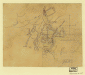
[Union troop positions northwest of Marietta, Georgia, June 10-July 3, 1864].

| Format |
Map |
|---|---|
| Dates |
1864 |
| Location |
Georgia Marietta United States |
| Language |
English |
| Subjects |
Civil War Georgia History Marietta Marietta (Ga.) United States |
- Title
- [Union troop positions northwest of Marietta, Georgia, June 10-July 3, 1864].
- Description
-
Relief shown by hachures.
-
Title from Stephenson's Civil War maps, 1989.
-
LC Civil War maps (2nd ed.), S93, 195
-
Available also through the Library of Congress Web site as a raster image.
-
At bottom of map: Schofield.
-
Similar to a map in the Atlas to accompany the official records of the Union and Confederate Armies, 1891-95, pl. 62, no. 13.
-
Pencil (some col.) and pen and ink on fold lined tracing paper with mended tears, mounted on paper. Losses along top.
-
1 ms. map : col. ; 30 x 35 cm.
- Subject Headings
-
-
Marietta (Ga.)--History--Civil War, 1861-1865
-
-
United States--Georgia--Marietta.
- Notes
-
-
Relief shown by hachures.
-
-
Title from Stephenson's Civil War maps, 1989.
-
-
LC Civil War maps (2nd ed.), S93, 195
-
-
Available also through the Library of Congress Web site as a raster image.
-
-
At bottom of map: Schofield.
-
-
Similar to a map in the Atlas to accompany the official records of the Union and Confederate Armies, 1891-95, pl. 62, no. 13.
-
-
Pencil (some col.) and pen and ink on fold lined tracing paper with mended tears, mounted on paper. Losses along top.
- Medium
-
1 ms. map : col. ; 30 x 35 cm.
- Call Number
-
G3924.M4S5 1864 .U53
- Repository
-
Library of Congress Geography and Map Division Washington, D.C. 20540-4650 USA dcu
- Digital Id
-
g3924m cws00093 http://hdl.loc.gov/loc.gmd/g3924m.cws00093
- Library of Congress Catalog Number
- 2006635271
Rights & Access
The maps in the Map Collections materials were either published prior to 1922, produced by the United States government, or both (see catalogue records that accompany each map for information regarding date of publication and source). The Library of Congress is providing access to these materials for educational and research purposes and is not aware of any U.S. copyright protection (see Title 17 of the United States Code) or any other restrictions in the Map Collection materials.
Note that the written permission of the copyright owners and/or other rights holders (such as publicity and/or privacy rights) is required for distribution, reproduction, or other use of protected items beyond that allowed by fair use or other statutory exemptions. Responsibility for making an independent legal assessment of an item and securing any necessary permissions ultimately rests with persons desiring to use the item.
More about Copyright and other Restrictions
For guidance about compiling full citations consult Citing Primary Sources.
Part of...
-
Civil War Maps
[2281]
-
Military Battles And Campaigns Cartographic Items
[3867]
-
Geography And Maps Division
[60803]
-
American Memory
[1121009]
More maps like this
-
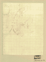
 [Union troop positions west of Marietta, Georgia, June? 1864].
Site:
American Memory-cultural, Main Catalog
Original Format:
Map
Date:
1864
View catalog record
[Union troop positions west of Marietta, Georgia, June? 1864].
Site:
American Memory-cultural, Main Catalog
Original Format:
Map
Date:
1864
View catalog record
-
 [Map of the environs of Olley Creek near Marietta, Georgia].
Site:
American Memory-cultural, Main Catalog
Original Format:
Map
Date:
1864
View catalog record
[Map of the environs of Olley Creek near Marietta, Georgia].
Site:
American Memory-cultural, Main Catalog
Original Format:
Map
Date:
1864
View catalog record
-
 [Map of the Union troop positions southwest of Marietta, Georgia, June 10-July 3, 1864].
Site:
American Memory-cultural, Main Catalog
Original Format:
Map
Date:
1864-07-03
View catalog record
[Map of the Union troop positions southwest of Marietta, Georgia, June 10-July 3, 1864].
Site:
American Memory-cultural, Main Catalog
Original Format:
Map
Date:
1864-07-03
View catalog record
-
 [Map showing the position of troops to the north of Marietta, Georgia. June 10-July 3, 1864] /
Contributor:
Skinner, C. W.
Site:
American Memory-cultural, Main Catalog
Original Format:
Map
Date:
1864-07-03
View catalog record
[Map showing the position of troops to the north of Marietta, Georgia. June 10-July 3, 1864] /
Contributor:
Skinner, C. W.
Site:
American Memory-cultural, Main Catalog
Original Format:
Map
Date:
1864-07-03
View catalog record
-
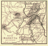 Map of Marietta and vicinity. [June 1864]
Contributor:
Western and Atlantic Railroad Company
Site:
American Memory-cultural, Main Catalog
Original Format:
Map
Date:
1864
View catalog record
Map of Marietta and vicinity. [June 1864]
Contributor:
Western and Atlantic Railroad Company
Site:
American Memory-cultural, Main Catalog
Original Format:
Map
Date:
1864
View catalog record
-
 [Union troop positions northwest of Marietta, Georgia, June? 1864].
Site:
American Memory-cultural, Main Catalog
Original Format:
Map
Date:
1864
View catalog record
[Union troop positions northwest of Marietta, Georgia, June? 1864].
Site:
American Memory-cultural, Main Catalog
Original Format:
Map
Date:
1864
View catalog record
-
 [Map of the environs of Olley Creek near Marietta, Georgia, July? 1864].
Site:
American Memory-cultural, Main Catalog
Original Format:
Map
Date:
1864
View catalog record
[Map of the environs of Olley Creek near Marietta, Georgia, July? 1864].
Site:
American Memory-cultural, Main Catalog
Original Format:
Map
Date:
1864
View catalog record
-
 Sketch of the roads &c near the position of this Div. on the left of the Army : [north of Marietta, Georgia].
Site:
American Memory-cultural, Main Catalog
Original Format:
Map
Date:
1864
View catalog record
Sketch of the roads &c near the position of this Div. on the left of the Army : [north of Marietta, Georgia].
Site:
American Memory-cultural, Main Catalog
Original Format:
Map
Date:
1864
View catalog record
-
 Map of Washington County, Ohio : from actual survey & records by Wm. Lorey.
Contributor:
Lorey, Wm
Site:
American Memory-cultural, Main Catalog
Original Format:
Map
Date:
1858
View catalog record
Map of Washington County, Ohio : from actual survey & records by Wm. Lorey.
Contributor:
Lorey, Wm
Site:
American Memory-cultural, Main Catalog
Original Format:
Map
Date:
1858
View catalog record
-
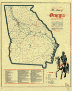
 The State of Georgia, Civil War Centennial, 1864 : showing the major campaign areas and engagement sites of the Union and Confederate armies /
Contributor:
Georgia. State Highway Dept
Site:
American Memory-cultural, Main Catalog
Original Format:
Map
Date:
1964
View catalog record
The State of Georgia, Civil War Centennial, 1864 : showing the major campaign areas and engagement sites of the Union and Confederate armies /
Contributor:
Georgia. State Highway Dept
Site:
American Memory-cultural, Main Catalog
Original Format:
Map
Date:
1964
View catalog record
-
 Lloyd's topographical map of Georgia from state surveys before the war showing railways, stations, villages, mills, &c.
Contributor:
Lloyd, James T.
Site:
American Memory-cultural, Main Catalog
Original Format:
Map
Date:
1864
View catalog record
Lloyd's topographical map of Georgia from state surveys before the war showing railways, stations, villages, mills, &c.
Contributor:
Lloyd, James T.
Site:
American Memory-cultural, Main Catalog
Original Format:
Map
Date:
1864
View catalog record
-
 The State of Georgia, showing the major campaign areas and engagement sites of the War between the States, 1861-1865.
Contributor:
Smith, J. Harmon
Site:
American Memory-cultural, Main Catalog
Original Format:
Map
Date:
1961
View catalog record
The State of Georgia, showing the major campaign areas and engagement sites of the War between the States, 1861-1865.
Contributor:
Smith, J. Harmon
Site:
American Memory-cultural, Main Catalog
Original Format:
Map
Date:
1961
View catalog record
-
 [Troop positions in Georgia].
Site:
American Memory-cultural, Main Catalog
Original Format:
Map
Date:
1864
View catalog record
[Troop positions in Georgia].
Site:
American Memory-cultural, Main Catalog
Original Format:
Map
Date:
1864
View catalog record
-
 Lloyd's Topographical map of Georgia from state surveys before the war showing railways, stations, villages, mills, &c. /
Contributor:
Lloyd, James T.
Site:
American Memory-cultural, Main Catalog
Original Format:
Map
Date:
1864
View catalog record
Lloyd's Topographical map of Georgia from state surveys before the war showing railways, stations, villages, mills, &c. /
Contributor:
Lloyd, James T.
Site:
American Memory-cultural, Main Catalog
Original Format:
Map
Date:
1864
View catalog record
-
 Map illustrating the first epoch of the Atlanta Campaign : embracing the region from the Tennessee River to the Oostanaula River, showing the positions held ...
Contributor:
Ruger, Edward
Site:
American Memory-cultural, Main Catalog
Original Format:
Map
Date:
1974
View catalog record
Map illustrating the first epoch of the Atlanta Campaign : embracing the region from the Tennessee River to the Oostanaula River, showing the positions held ...
Contributor:
Ruger, Edward
Site:
American Memory-cultural, Main Catalog
Original Format:
Map
Date:
1974
View catalog record
-
 "Atlanta campaign," left wing 16th Army Corps., May 4th to Sept. 8th, 1864 : Maj. Genl. G.M. Dodge, comdg., Genls. Corse and Burke, comdg. divisions ...
Contributor:
Bell, C. J.
Site:
American Memory-cultural, Main Catalog
Original Format:
Map
Date:
1890
View catalog record
"Atlanta campaign," left wing 16th Army Corps., May 4th to Sept. 8th, 1864 : Maj. Genl. G.M. Dodge, comdg., Genls. Corse and Burke, comdg. divisions ...
Contributor:
Bell, C. J.
Site:
American Memory-cultural, Main Catalog
Original Format:
Map
Date:
1890
View catalog record
You might also like
-

 The Great Harkins Well. Marietta Creek
Contributor:
Waud, Alfred R.
Site:
Main Catalog
Original Format:
Photo, Print, Drawing
Date:
1860
The Great Harkins Well. Marietta Creek
Contributor:
Waud, Alfred R.
Site:
Main Catalog
Original Format:
Photo, Print, Drawing
Date:
1860
-
 Covered bridge near Marietta, Georgia
Contributor:
Mydans, Carl
Site:
Prints & Photographs
Original Format:
Photo, Print, Drawing
Date:
1936
Covered bridge near Marietta, Georgia
Contributor:
Mydans, Carl
Site:
Prints & Photographs
Original Format:
Photo, Print, Drawing
Date:
1936
-
 [Lynching of Leo Frank, Marietta, Georgia]
Site:
Prints & Photographs, Main Catalog
Original Format:
Photo, Print, Drawing
Date:
1915
View catalog record
[Lynching of Leo Frank, Marietta, Georgia]
Site:
Prints & Photographs, Main Catalog
Original Format:
Photo, Print, Drawing
Date:
1915
View catalog record
-
 [Leo Frank, head-and-shoulders portrait, facing right]
Site:
Prints & Photographs, Main Catalog
Original Format:
Photo, Print, Drawing
Date:
1913
View catalog record
[Leo Frank, head-and-shoulders portrait, facing right]
Site:
Prints & Photographs, Main Catalog
Original Format:
Photo, Print, Drawing
Date:
1913
View catalog record
-
 Uncle Jim and Mammy Julia greet McAdoo at his birthplace
Site:
Prints & Photographs, Main Catalog
Original Format:
Photo, Print, Drawing
Date:
1924
View catalog record
Uncle Jim and Mammy Julia greet McAdoo at his birthplace
Site:
Prints & Photographs, Main Catalog
Original Format:
Photo, Print, Drawing
Date:
1924
View catalog record
-
 General Sherman's advance
Contributor:
Davis, Theodore R.
Site:
Prints & Photographs, Main Catalog
Original Format:
Photo, Print, Drawing
Date:
1864
View catalog record
General Sherman's advance
Contributor:
Davis, Theodore R.
Site:
Prints & Photographs, Main Catalog
Original Format:
Photo, Print, Drawing
Date:
1864
View catalog record