Map
Plaza de la villa de Galvez.

| Format |
Map |
|---|---|
| Dates |
1778 |
| Location |
Galvez Louisiana Lousiana United States |
| Language |
Castilian Spanish |
| Subjects |
Galvez Galvez (La.) Louisiana United States |
- Title
- Plaza de la villa de Galvez.
- Description
-
Scale ca. 1:1,000.
-
Title from verso.
-
Manuscript, pen-and-ink and watercolor.
-
Oriented with north toward the bottom.
-
"Carolo ignante, urbem adisicat amor, Galvez ad honorem, nomen dedit que suum. Anno dñi. ML.C.C.D.XX.VIII."
-
LC Luso-Hispanic World, 957
-
Includes table of statistics.
-
Available also through the Library of Congress Web site as a raster image.
-
col. map on sheet 38 x 25 cm.
-
"Carolo ignante, urbem adisicat amor, Galvez ad honorem, nomen dedit que suum. Anno dñi. ML.C.C.D.XX.VIII."
- Created Published
-
[1778]
- Subject Headings
-
-
Galvez (La.)
-
-
United States--Louisiana--Galvez.
- Notes
-
-
Scale ca. 1:1,000.
-
-
Title from verso.
-
-
Manuscript, pen-and-ink and watercolor.
-
-
Oriented with north toward the bottom.
-
-
"Carolo ignante, urbem adisicat amor, Galvez ad honorem, nomen dedit que suum. Anno dñi. ML.C.C.D.XX.VIII."
-
-
LC Luso-Hispanic World, 957
-
-
Includes table of statistics.
-
-
Available also through the Library of Congress Web site as a raster image.
- Medium
-
col. map on sheet 38 x 25 cm.
- Call Number
-
G4014.G225 1778 .P5
- Repository
-
Library of Congress Geography and Map Division Washington, D.C. 20540-4650 USA dcu
- Digital Id
-
g4014g ct000274 http://hdl.loc.gov/loc.gmd/g4014g.ct000274
- Library of Congress Catalog Number
- 73691644
Rights & Access
The maps in the Map Collections materials were either published prior to 1922, produced by the United States government, or both (see catalogue records that accompany each map for information regarding date of publication and source). The Library of Congress is providing access to these materials for educational and research purposes and is not aware of any U.S. copyright protection (see Title 17 of the United States Code) or any other restrictions in the Map Collection materials.
Note that the written permission of the copyright owners and/or other rights holders (such as publicity and/or privacy rights) is required for distribution, reproduction, or other use of protected items beyond that allowed by fair use or other statutory exemptions. Responsibility for making an independent legal assessment of an item and securing any necessary permissions ultimately rests with persons desiring to use the item.
More about Copyright and other Restrictions
For guidance about compiling full citations consult Citing Primary Sources.
Part of...
-
Louisiana: European Explorations And The Louisiana Purchase
[77]
-
General Maps
[2477]
-
Geography And Maps Division
[60803]
-
American Memory
[1121009]
More maps like this
-
 Plan of New Orleans the capital of Louisiana; with the disposition of its quarters and canals as they have been traced by Mr. de la ...
Contributor:
Jefferys, Thomas
Site:
American Memory-cultural, Main Catalog
Original Format:
Map
Date:
1759
View catalog record
Plan of New Orleans the capital of Louisiana; with the disposition of its quarters and canals as they have been traced by Mr. de la ...
Contributor:
Jefferys, Thomas
Site:
American Memory-cultural, Main Catalog
Original Format:
Map
Date:
1759
View catalog record
-
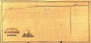 Map of the town of Alexandria, Louisiana /
Contributor:
Bringhurst, R. W.
Site:
American Memory-cultural, Main Catalog
Original Format:
Map
Date:
1872
View catalog record
Map of the town of Alexandria, Louisiana /
Contributor:
Bringhurst, R. W.
Site:
American Memory-cultural, Main Catalog
Original Format:
Map
Date:
1872
View catalog record
-
 Plan of New Orleans the capital of Louisiana; with the disposition of its quarters and canals as they have been traced by Mr. de la ...
Contributor:
Jefferys, Thomas
Site:
American Memory-cultural, Main Catalog
Original Format:
Map
Date:
1759
View catalog record
Plan of New Orleans the capital of Louisiana; with the disposition of its quarters and canals as they have been traced by Mr. de la ...
Contributor:
Jefferys, Thomas
Site:
American Memory-cultural, Main Catalog
Original Format:
Map
Date:
1759
View catalog record
-
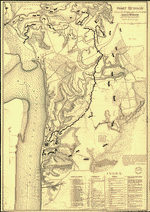
 Map of Port Hudson and vicinity
Contributor:
Houston, D. C.
Site:
American Memory-cultural, Main Catalog
Original Format:
Map
Date:
1875
View catalog record
Map of Port Hudson and vicinity
Contributor:
Houston, D. C.
Site:
American Memory-cultural, Main Catalog
Original Format:
Map
Date:
1875
View catalog record
-
 Norman's plan of New Orleans & environs, 1845.
Contributor:
Möllhausen, Henry, Möllhausen, Henry
Site:
American Memory-cultural, Main Catalog
Original Format:
Map
Date:
1845
View catalog record
Norman's plan of New Orleans & environs, 1845.
Contributor:
Möllhausen, Henry, Möllhausen, Henry
Site:
American Memory-cultural, Main Catalog
Original Format:
Map
Date:
1845
View catalog record
-
 Plan showing the boundaries of the great conflagration of New Orleans on the 21st of March 1788.
Site:
American Memory-cultural, Main Catalog
Original Format:
Map
View catalog record
Plan showing the boundaries of the great conflagration of New Orleans on the 21st of March 1788.
Site:
American Memory-cultural, Main Catalog
Original Format:
Map
View catalog record
-
 Plan de la Nouvelle Orleans.
Contributor:
Bellin, Jacques Nicolas
Site:
American Memory-cultural, Main Catalog
Original Format:
Map
Date:
1764
View catalog record
Plan de la Nouvelle Orleans.
Contributor:
Bellin, Jacques Nicolas
Site:
American Memory-cultural, Main Catalog
Original Format:
Map
Date:
1764
View catalog record
-
 Plan showing the defences of the fort on Red River,
Contributor:
United States. Navy
Site:
American Memory-cultural, Main Catalog
Original Format:
Map
Date:
1863
View catalog record
Plan showing the defences of the fort on Red River,
Contributor:
United States. Navy
Site:
American Memory-cultural, Main Catalog
Original Format:
Map
Date:
1863
View catalog record
-
 Plan of the city and suburbs of New Orleans : from an actual survey made in 1815 /
Contributor:
Tanesse, I.
Site:
American Memory-cultural, Main Catalog
Original Format:
Map
Date:
1817
View catalog record
Plan of the city and suburbs of New Orleans : from an actual survey made in 1815 /
Contributor:
Tanesse, I.
Site:
American Memory-cultural, Main Catalog
Original Format:
Map
Date:
1817
View catalog record
-
 Plan of New Orleans the capital of Louisiana; with the disposition of its quarters and canals as they have been traced by Mr. de la ...
Contributor:
Jefferys, Thomas
Site:
American Memory-cultural, Main Catalog
Original Format:
Map
Date:
1759
View catalog record
Plan of New Orleans the capital of Louisiana; with the disposition of its quarters and canals as they have been traced by Mr. de la ...
Contributor:
Jefferys, Thomas
Site:
American Memory-cultural, Main Catalog
Original Format:
Map
Date:
1759
View catalog record
-
 Approaches to Fort Butte La Rose, Louisiana,
Contributor:
United States Coast Survey
Site:
American Memory-cultural, Main Catalog
Original Format:
Map
Date:
1863
View catalog record
Approaches to Fort Butte La Rose, Louisiana,
Contributor:
United States Coast Survey
Site:
American Memory-cultural, Main Catalog
Original Format:
Map
Date:
1863
View catalog record
-
 Plan of the City of New Orleans and adjacent plantations /
Contributor:
Trudeau, Charles Laveau
Site:
American Memory-cultural, Main Catalog
Original Format:
Map
Date:
1875
View catalog record
Plan of the City of New Orleans and adjacent plantations /
Contributor:
Trudeau, Charles Laveau
Site:
American Memory-cultural, Main Catalog
Original Format:
Map
Date:
1875
View catalog record
-
 Plan of New Orleans.
Contributor:
Pittman, Philip
Site:
American Memory-cultural, Main Catalog
Original Format:
Map
Date:
1770
View catalog record
Plan of New Orleans.
Contributor:
Pittman, Philip
Site:
American Memory-cultural, Main Catalog
Original Format:
Map
Date:
1770
View catalog record
-
 Plan de la Nouvelle Orleans.
Site:
American Memory-cultural, Main Catalog
Original Format:
Map
Date:
1722
View catalog record
Plan de la Nouvelle Orleans.
Site:
American Memory-cultural, Main Catalog
Original Format:
Map
Date:
1722
View catalog record
-
 Port Hudson Compiled from government surveys and other sources and drawn by Charles McGregor, Historian of the 15th N.H. Volunterrs. [Lith. by] Geo. H. Walker ...
Contributor:
McGregor, Charles
Site:
American Memory-cultural, Main Catalog
Original Format:
Map
Date:
1900
View catalog record
Port Hudson Compiled from government surveys and other sources and drawn by Charles McGregor, Historian of the 15th N.H. Volunterrs. [Lith. by] Geo. H. Walker ...
Contributor:
McGregor, Charles
Site:
American Memory-cultural, Main Catalog
Original Format:
Map
Date:
1900
View catalog record
-
 Map of Fort de Russy.
Site:
American Memory-cultural, Main Catalog
Original Format:
Map
Date:
1864
View catalog record
Map of Fort de Russy.
Site:
American Memory-cultural, Main Catalog
Original Format:
Map
Date:
1864
View catalog record
You might also like
-
-
 Birds' eye view of New-Orleans
Contributor:
Bachmann, John
Site:
American Memory-cultural, Main Catalog
Original Format:
Photo, Print, Drawing
Date:
1851
View catalog record
Birds' eye view of New-Orleans
Contributor:
Bachmann, John
Site:
American Memory-cultural, Main Catalog
Original Format:
Photo, Print, Drawing
Date:
1851
View catalog record
-
 New Orleans from St. Patrick's Church 1852
Contributor:
Smith, B. F. (Benjamin F.), Smith, B. F.
Site:
Prints & Photographs, Main Catalog
Original Format:
Photo, Print, Drawing
Date:
1852
View catalog record
New Orleans from St. Patrick's Church 1852
Contributor:
Smith, B. F. (Benjamin F.), Smith, B. F.
Site:
Prints & Photographs, Main Catalog
Original Format:
Photo, Print, Drawing
Date:
1852
View catalog record
-
 The city of New Orleans, and the Mississippi River Lake Pontchartrain in distance.
Contributor:
Currier & Ives
Site:
American Memory-cultural, Main Catalog
Original Format:
Photo, Print, Drawing
Date:
1885
View catalog record
The city of New Orleans, and the Mississippi River Lake Pontchartrain in distance.
Contributor:
Currier & Ives
Site:
American Memory-cultural, Main Catalog
Original Format:
Photo, Print, Drawing
Date:
1885
View catalog record
-
 Camp Beauregard, Louisiana
Contributor:
Spencer & Wyckoff
Site:
Prints & Photographs, Main Catalog
Original Format:
Photo, Print, Drawing
Date:
1941
View catalog record
Camp Beauregard, Louisiana
Contributor:
Spencer & Wyckoff
Site:
Prints & Photographs, Main Catalog
Original Format:
Photo, Print, Drawing
Date:
1941
View catalog record
-


