Map
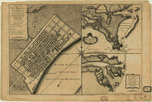
La Luisiana cedida al Rei N. S. por S. M. Christianisima, con la Nueva Orleans, è isla en que se halla esta ciudad. Construida sobre el mapa de Mr. d'Anville.

| Format |
Map |
|---|---|
| Contributors |
LóPez De Vargas Machuca, TomáS LóPez De Vargas Machuca, TomáS |
| Dates |
1762 |
| Location |
Louisiana Lousiana Mississippi River Valley New Orleans United States |
| Language |
Castilian Spanish |
| Subjects |
Louisiana Mississippi River Valley New Orleans New Orleans (La.) United States |
- Title
- La Luisiana cedida al Rei N. S. por S. M. Christianisima, con la Nueva Orleans, è isla en que se halla esta ciudad. Construida sobre el mapa de Mr. d'Anville.
- Description
-
Scale ca. 1:1,250,000.
-
Relief shown pictorially.
-
"Longitud de la isla del Hierro."
-
Shows Mississippi Valley north to the Canadian border.
-
Includes inset of "Plano de la Nueva Orleans segun el de M. Bellin," ca. 1:5,370, with index to points of interest.
-
LC Maps of North America, 1750-1789, 1674
-
Available also through the Library of Congress Web site as a raster image.
-
map 40 x 40 cm.
- Creator
- López de Vargas Machuca, Tomás,
- Created Published
-
Madrid, 1762.
- Subject Headings
-
-
Louisiana
-
-
Mississippi River Valley
-
-
New Orleans (La.)
-
-
United States--Louisiana.
-
-
United States--Mississippi River Valley.
-
-
United States--Louisiana--New Orleans.
- Notes
-
-
Scale ca. 1:1,250,000.
-
-
Relief shown pictorially.
-
-
"Longitud de la isla del Hierro."
-
-
Shows Mississippi Valley north to the Canadian border.
-
-
Includes inset of "Plano de la Nueva Orleans segun el de M. Bellin," ca. 1:5,370, with index to points of interest.
-
-
LC Maps of North America, 1750-1789, 1674
-
-
Available also through the Library of Congress Web site as a raster image.
- Medium
-
map 40 x 40 cm.
- Call Number
-
G4010 1762 .L6
- Repository
-
Library of Congress Geography and Map Division Washington, D.C. 20540-4650 USA dcu
- Digital Id
-
g4010 ar167400 http://hdl.loc.gov/loc.gmd/g4010.ar167400
- Library of Congress Catalog Number
- 74692110
Rights & Access
The maps in the Map Collections materials were either published prior to 1922, produced by the United States government, or both (see catalogue records that accompany each map for information regarding date of publication and source). The Library of Congress is providing access to these materials for educational and research purposes and is not aware of any U.S. copyright protection (see Title 17 of the United States Code) or any other restrictions in the Map Collection materials.
Note that the written permission of the copyright owners and/or other rights holders (such as publicity and/or privacy rights) is required for distribution, reproduction, or other use of protected items beyond that allowed by fair use or other statutory exemptions. Responsibility for making an independent legal assessment of an item and securing any necessary permissions ultimately rests with persons desiring to use the item.
More about Copyright and other Restrictions
For guidance about compiling full citations consult Citing Primary Sources.
Part of...
More maps like this
-
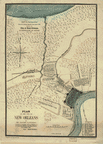
 Plan of New Orleans the capital of Louisiana; with the disposition of its quarters and canals as they have been traced by Mr. de la ...
Contributor:
Jefferys, Thomas
Site:
American Memory-cultural, Main Catalog
Original Format:
Map
Date:
1759
View catalog record
Plan of New Orleans the capital of Louisiana; with the disposition of its quarters and canals as they have been traced by Mr. de la ...
Contributor:
Jefferys, Thomas
Site:
American Memory-cultural, Main Catalog
Original Format:
Map
Date:
1759
View catalog record
-
 Norman's plan of New Orleans & environs, 1845.
Contributor:
Möllhausen, Henry, Möllhausen, Henry
Site:
American Memory-cultural, Main Catalog
Original Format:
Map
Date:
1845
View catalog record
Norman's plan of New Orleans & environs, 1845.
Contributor:
Möllhausen, Henry, Möllhausen, Henry
Site:
American Memory-cultural, Main Catalog
Original Format:
Map
Date:
1845
View catalog record
-
 Plan showing the boundaries of the great conflagration of New Orleans on the 21st of March 1788.
Site:
American Memory-cultural, Main Catalog
Original Format:
Map
View catalog record
Plan showing the boundaries of the great conflagration of New Orleans on the 21st of March 1788.
Site:
American Memory-cultural, Main Catalog
Original Format:
Map
View catalog record
-
 Plan de la Nouvelle Orleans.
Contributor:
Bellin, Jacques Nicolas
Site:
American Memory-cultural, Main Catalog
Original Format:
Map
Date:
1764
View catalog record
Plan de la Nouvelle Orleans.
Contributor:
Bellin, Jacques Nicolas
Site:
American Memory-cultural, Main Catalog
Original Format:
Map
Date:
1764
View catalog record
-
 Plan of the city and suburbs of New Orleans : from an actual survey made in 1815 /
Contributor:
Tanesse, I.
Site:
American Memory-cultural, Main Catalog
Original Format:
Map
Date:
1817
View catalog record
Plan of the city and suburbs of New Orleans : from an actual survey made in 1815 /
Contributor:
Tanesse, I.
Site:
American Memory-cultural, Main Catalog
Original Format:
Map
Date:
1817
View catalog record
-
 Plan of New Orleans the capital of Louisiana; with the disposition of its quarters and canals as they have been traced by Mr. de la ...
Contributor:
Jefferys, Thomas
Site:
American Memory-cultural, Main Catalog
Original Format:
Map
Date:
1759
View catalog record
Plan of New Orleans the capital of Louisiana; with the disposition of its quarters and canals as they have been traced by Mr. de la ...
Contributor:
Jefferys, Thomas
Site:
American Memory-cultural, Main Catalog
Original Format:
Map
Date:
1759
View catalog record
-
 Plan of the City of New Orleans and adjacent plantations /
Contributor:
Trudeau, Charles Laveau
Site:
American Memory-cultural, Main Catalog
Original Format:
Map
Date:
1875
View catalog record
Plan of the City of New Orleans and adjacent plantations /
Contributor:
Trudeau, Charles Laveau
Site:
American Memory-cultural, Main Catalog
Original Format:
Map
Date:
1875
View catalog record
-
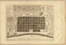 Plan of New Orleans.
Contributor:
Pittman, Philip
Site:
American Memory-cultural, Main Catalog
Original Format:
Map
Date:
1770
View catalog record
Plan of New Orleans.
Contributor:
Pittman, Philip
Site:
American Memory-cultural, Main Catalog
Original Format:
Map
Date:
1770
View catalog record
-
 Plan de la Nouvelle Orleans.
Site:
American Memory-cultural, Main Catalog
Original Format:
Map
Date:
1722
View catalog record
Plan de la Nouvelle Orleans.
Site:
American Memory-cultural, Main Catalog
Original Format:
Map
Date:
1722
View catalog record
-
 New Orleans, La. and its vicinity.
Contributor:
Wells, J.
Site:
American Memory-cultural, Main Catalog
Original Format:
Map
Date:
1863
View catalog record
New Orleans, La. and its vicinity.
Contributor:
Wells, J.
Site:
American Memory-cultural, Main Catalog
Original Format:
Map
Date:
1863
View catalog record
-
 Plano de Puerto-Rico: Dale a Luz.
Contributor:
López de Vargas Machuca, Tomás, López de Vargas Machuca, Tomás
Site:
American Memory-cultural, Main Catalog
Original Format:
Map
Date:
1785
View catalog record
Plano de Puerto-Rico: Dale a Luz.
Contributor:
López de Vargas Machuca, Tomás, López de Vargas Machuca, Tomás
Site:
American Memory-cultural, Main Catalog
Original Format:
Map
Date:
1785
View catalog record
-
 Plano de la ciudad y puerto de San Agustin de la Florida.
Contributor:
López de Vargas Machuca, Tomás, López de Vargas Machuca, Tomás
Site:
American Memory-cultural, Main Catalog
Original Format:
Map
Date:
1783
View catalog record
Plano de la ciudad y puerto de San Agustin de la Florida.
Contributor:
López de Vargas Machuca, Tomás, López de Vargas Machuca, Tomás
Site:
American Memory-cultural, Main Catalog
Original Format:
Map
Date:
1783
View catalog record
-
 [Map of New Orleans and vicinity] /
Contributor:
Pintado, Vicente Sebastián, Pintado, Vicente Sebastián
Site:
American Memory-cultural, Main Catalog
Original Format:
Map
Date:
1819
View catalog record
[Map of New Orleans and vicinity] /
Contributor:
Pintado, Vicente Sebastián, Pintado, Vicente Sebastián
Site:
American Memory-cultural, Main Catalog
Original Format:
Map
Date:
1819
View catalog record
-
 Plan du rez de chaussée, du corps de logis double, de l'intendance de la Nlle Orléans, pour estre construit en maçonnerie de briques, entre cour ...
Site:
American Memory-cultural, Main Catalog
Original Format:
Map
Date:
1749
View catalog record
Plan du rez de chaussée, du corps de logis double, de l'intendance de la Nlle Orléans, pour estre construit en maçonnerie de briques, entre cour ...
Site:
American Memory-cultural, Main Catalog
Original Format:
Map
Date:
1749
View catalog record
-

 Terrestrial lidar datasets of New Orleans, Louisiana, levee failures from Hurricane Katrina, August 29, 2005
Site:
Main Catalog
Original Format:
Map
Date:
2005-08-29
Terrestrial lidar datasets of New Orleans, Louisiana, levee failures from Hurricane Katrina, August 29, 2005
Site:
Main Catalog
Original Format:
Map
Date:
2005-08-29
You might also like
-
 Birds' eye view of New-Orleans
Contributor:
Bachmann, John
Site:
American Memory-cultural, Main Catalog
Original Format:
Photo, Print, Drawing
Date:
1851
View catalog record
Birds' eye view of New-Orleans
Contributor:
Bachmann, John
Site:
American Memory-cultural, Main Catalog
Original Format:
Photo, Print, Drawing
Date:
1851
View catalog record
-
 New Orleans from St. Patrick's Church 1852
Contributor:
Smith, B. F. (Benjamin F.), Smith, B. F.
Site:
Prints & Photographs, Main Catalog
Original Format:
Photo, Print, Drawing
Date:
1852
View catalog record
New Orleans from St. Patrick's Church 1852
Contributor:
Smith, B. F. (Benjamin F.), Smith, B. F.
Site:
Prints & Photographs, Main Catalog
Original Format:
Photo, Print, Drawing
Date:
1852
View catalog record
-
 The city of New Orleans, and the Mississippi River Lake Pontchartrain in distance.
Contributor:
Currier & Ives
Site:
American Memory-cultural, Main Catalog
Original Format:
Photo, Print, Drawing
Date:
1885
View catalog record
The city of New Orleans, and the Mississippi River Lake Pontchartrain in distance.
Contributor:
Currier & Ives
Site:
American Memory-cultural, Main Catalog
Original Format:
Photo, Print, Drawing
Date:
1885
View catalog record
-
-
Birds' eye view of New-Orleans
Contributor:
Bachmann, John
Site:
Prints & Photographs, Main Catalog
Original Format:
Photo, Print, Drawing
Date:
1851
View catalog record
-
The city of New Orleans, and the Mississippi River Lake Pontchartrain in distance.
Contributor:
Currier & Ives
Site:
Prints & Photographs, Main Catalog
Original Format:
Photo, Print, Drawing
Date:
1885
View catalog record
