Map
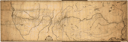
A map of Lewis and Clark's track, across the western portion of North America from the Mississippi to the Pacific Ocean : by order of the executive of the United States in 1804, 5 & 6 /

| Format |
Map |
|---|---|
| Contributors |
Lewis, Samuel |
| Dates |
1814 |
| Location |
Northwestern States United States |
| Language |
English |
| Subjects |
Lewis And Clark Expedition Northwestern States United States |
- Title
- A map of Lewis and Clark's track, across the western portion of North America from the Mississippi to the Pacific Ocean : by order of the executive of the United States in 1804, 5 & 6 /
- Description
-
Scale ca. 1:4,300,000.
-
Relief shown by hachures.
-
Meridian: London and Washington.
-
From Lewis, Meriwether, History of the expedition under the command of Captains Lewis and Clark, 1814.
-
Available also through the Library of Congress Web site as a raster image.
-
1 map ; 30 x 70 cm.
- Creator
- Lewis, Samuel,
- Created Published
-
[Philadelphia : Bradford and Inskeep, 1814]
- Subject Headings
-
-
Lewis and Clark Expedition--(1804-1806)
-
-
Northwestern States
-
-
United States--Northwestern States.
- Notes
-
-
Scale ca. 1:4,300,000.
-
-
Relief shown by hachures.
-
-
Meridian: London and Washington.
-
-
From Lewis, Meriwether, History of the expedition under the command of Captains Lewis and Clark, 1814.
-
-
Available also through the Library of Congress Web site as a raster image.
- Medium
-
1 map ; 30 x 70 cm.
- Call Number
-
G4126.S12 1814 .L4
- Repository
-
Library of Congress Geography and Map Division Washington, D.C. 20540-4650 USA dcu
- Digital Id
-
g4126s ct000028 http://hdl.loc.gov/loc.gmd/g4126s.ct000028
- Library of Congress Catalog Number
- 79692907
Rights & Access
The maps in the Map Collections materials were either published prior to 1922, produced by the United States government, or both (see catalogue records that accompany each map for information regarding date of publication and source). The Library of Congress is providing access to these materials for educational and research purposes and is not aware of any U.S. copyright protection (see Title 17 of the United States Code) or any other restrictions in the Map Collection materials.
Note that the written permission of the copyright owners and/or other rights holders (such as publicity and/or privacy rights) is required for distribution, reproduction, or other use of protected items beyond that allowed by fair use or other statutory exemptions. Responsibility for making an independent legal assessment of an item and securing any necessary permissions ultimately rests with persons desiring to use the item.
More about Copyright and other Restrictions
For guidance about compiling full citations consult Citing Primary Sources.
Part of...
-
Louisiana: European Explorations And The Louisiana Purchase
[77]
-
Discovery And Exploration
[150]
-
Geography And Maps Division
[60803]
-
American Memory
[1121009]
More maps like this
-
 A map of Lewis and Clark's track across the western portion of North America, from the Mississippi to the Pacific Ocean : by order of ...
Contributor:
Lewis, Samuel
Site:
American Memory-cultural, Main Catalog
Original Format:
Map
Date:
1814
View catalog record
A map of Lewis and Clark's track across the western portion of North America, from the Mississippi to the Pacific Ocean : by order of ...
Contributor:
Lewis, Samuel
Site:
American Memory-cultural, Main Catalog
Original Format:
Map
Date:
1814
View catalog record
-
 [Lewis and Clark map, with annotations in brown ink by Meriwether Lewis, tracing showing the Mississippi, the Missouri for a short distance above Kansas, Lakes ...
Contributor:
King, N.
Site:
American Memory-cultural, Main Catalog
Original Format:
Map
Date:
1803
View catalog record
[Lewis and Clark map, with annotations in brown ink by Meriwether Lewis, tracing showing the Mississippi, the Missouri for a short distance above Kansas, Lakes ...
Contributor:
King, N.
Site:
American Memory-cultural, Main Catalog
Original Format:
Map
Date:
1803
View catalog record
-
 A map of the discoveries of Capt. Lewis & Clark from the Rockey Mountain and the River Lewis to the Cap of Disappointement or the ...
Contributor:
Frazer, Robert
Site:
American Memory-cultural, Main Catalog
Original Format:
Map
Date:
1807
View catalog record
A map of the discoveries of Capt. Lewis & Clark from the Rockey Mountain and the River Lewis to the Cap of Disappointement or the ...
Contributor:
Frazer, Robert
Site:
American Memory-cultural, Main Catalog
Original Format:
Map
Date:
1807
View catalog record
-
 Discovering the legacy of Lewis and Clark : bicentennial commemoration 2003-2006 /
Site:
American Memory-cultural, Main Catalog
Original Format:
Map
Date:
2003
View catalog record
Discovering the legacy of Lewis and Clark : bicentennial commemoration 2003-2006 /
Site:
American Memory-cultural, Main Catalog
Original Format:
Map
Date:
2003
View catalog record
-
 The State of New Jersey, compiled from the most authentic information.
Contributor:
Lewis, Samuel
Site:
American Memory-cultural, Main Catalog
Original Format:
Map
Date:
1795
View catalog record
The State of New Jersey, compiled from the most authentic information.
Contributor:
Lewis, Samuel
Site:
American Memory-cultural, Main Catalog
Original Format:
Map
Date:
1795
View catalog record
-
 The State of Maryland from the best authorities.
Contributor:
Lewis, Samuel
Site:
American Memory-cultural, Main Catalog
Original Format:
Map
Date:
1795
View catalog record
The State of Maryland from the best authorities.
Contributor:
Lewis, Samuel
Site:
American Memory-cultural, Main Catalog
Original Format:
Map
Date:
1795
View catalog record
-
 The State of New Hampshire. Compiled chiefly from actual surveys.
Contributor:
Lewis, Samuel
Site:
American Memory-cultural, Main Catalog
Original Format:
Map
Date:
1794
View catalog record
The State of New Hampshire. Compiled chiefly from actual surveys.
Contributor:
Lewis, Samuel
Site:
American Memory-cultural, Main Catalog
Original Format:
Map
Date:
1794
View catalog record
-
 The State of New Jersey, compiled from the most authentic information.
Contributor:
Lewis, Samuel
Site:
American Memory-cultural, Main Catalog
Original Format:
Map
Date:
1795
View catalog record
The State of New Jersey, compiled from the most authentic information.
Contributor:
Lewis, Samuel
Site:
American Memory-cultural, Main Catalog
Original Format:
Map
Date:
1795
View catalog record
-
 Louisiana.
Contributor:
Lewis, Samuel
Site:
American Memory-cultural, Main Catalog
Original Format:
Map
Date:
1805
View catalog record
Louisiana.
Contributor:
Lewis, Samuel
Site:
American Memory-cultural, Main Catalog
Original Format:
Map
Date:
1805
View catalog record
-
 A correct map of the seat of war.
Contributor:
Lewis, Samuel
Site:
American Memory-cultural, Main Catalog
Original Format:
Map
Date:
1812
View catalog record
A correct map of the seat of war.
Contributor:
Lewis, Samuel
Site:
American Memory-cultural, Main Catalog
Original Format:
Map
Date:
1812
View catalog record
-
 Copy of a survey return'd by Mr. Sam Lewis, surveyor of Botetourt Coun[t]y. Surveyed for George Washington 2950 acres of land (by virtue of a ...
Contributor:
Lewis, Samuel
Site:
American Memory-cultural, Main Catalog
Original Format:
Map
Date:
1774
View catalog record
Copy of a survey return'd by Mr. Sam Lewis, surveyor of Botetourt Coun[t]y. Surveyed for George Washington 2950 acres of land (by virtue of a ...
Contributor:
Lewis, Samuel
Site:
American Memory-cultural, Main Catalog
Original Format:
Map
Date:
1774
View catalog record
-
 National parks of the Midwest.
Contributor:
United States. National Park Service
Site:
American Memory-cultural, Main Catalog
Original Format:
Map
Date:
1968
View catalog record
National parks of the Midwest.
Contributor:
United States. National Park Service
Site:
American Memory-cultural, Main Catalog
Original Format:
Map
Date:
1968
View catalog record
-
 Touring map of the Custer Battlefield Hiway: the scenic route to the west.
Contributor:
Mulford, John C.
Site:
American Memory-cultural, Main Catalog
Original Format:
Map
Date:
1925
View catalog record
Touring map of the Custer Battlefield Hiway: the scenic route to the west.
Contributor:
Mulford, John C.
Site:
American Memory-cultural, Main Catalog
Original Format:
Map
Date:
1925
View catalog record
-
 Map of the country from Lake Superior to the Pacific Ocean. From the latest explorations and surveys to accompany the report of the New York ...
Contributor:
G.W. & C.B. Colton & Co
Site:
American Memory-cultural, Main Catalog
Original Format:
Map
Date:
1867
View catalog record
Map of the country from Lake Superior to the Pacific Ocean. From the latest explorations and surveys to accompany the report of the New York ...
Contributor:
G.W. & C.B. Colton & Co
Site:
American Memory-cultural, Main Catalog
Original Format:
Map
Date:
1867
View catalog record
-
 Topographical map of the road from Missouri to Oregon, commencing at the mouth of the Kansas in the Missouri River and ending at the mouth ...
Contributor:
Frémont, John Charles, Frémont, John Charles
Site:
American Memory-cultural, Main Catalog
Original Format:
Map
Date:
1846
View catalog record
Topographical map of the road from Missouri to Oregon, commencing at the mouth of the Kansas in the Missouri River and ending at the mouth ...
Contributor:
Frémont, John Charles, Frémont, John Charles
Site:
American Memory-cultural, Main Catalog
Original Format:
Map
Date:
1846
View catalog record
-
 Preliminary sketch of the Northern Pacific Rail Road exploration and survey, by I. I. Stevens, Governor of Washington Territory.
Contributor:
Stevens, Isaac Ingalls
Site:
American Memory-cultural, Main Catalog
Original Format:
Map
Date:
1855
View catalog record
Preliminary sketch of the Northern Pacific Rail Road exploration and survey, by I. I. Stevens, Governor of Washington Territory.
Contributor:
Stevens, Isaac Ingalls
Site:
American Memory-cultural, Main Catalog
Original Format:
Map
Date:
1855
View catalog record
You might also like
-

 People engaged in outdoor activities in the Northwestern United States.
Site:
Main Catalog
Original Format:
Photo, Print, Drawing
Date:
1905
People engaged in outdoor activities in the Northwestern United States.
Site:
Main Catalog
Original Format:
Photo, Print, Drawing
Date:
1905
-
 The Northwest illustrated for tourists of 1874.
Contributor:
Chicago and Northwestern railway [company]
Site:
Main Catalog
Original Format:
Book
Date:
1874
The Northwest illustrated for tourists of 1874.
Contributor:
Chicago and Northwestern railway [company]
Site:
Main Catalog
Original Format:
Book
Date:
1874
-
Valley, plain and peak ... Scenes on the line of the Great northern railway.
Contributor:
Great Northern Railway Company (U.S.)
Site:
Main Catalog
Original Format:
Book
Date:
1894
-
Procurement contracting in the affected counties of the Northwest Forest Plan : 12 years of change /
Contributor:
Moseley, Cassandra
Site:
Main Catalog
Original Format:
Book
Date:
2006
-
 People engaged in outdoor activities in the Northwestern United States.
Contributor:
Blosser, J. A., Blosser Scenic Art Company
Site:
Prints & Photographs
Original Format:
Photo, Print, Drawing
Date:
1905
People engaged in outdoor activities in the Northwestern United States.
Contributor:
Blosser, J. A., Blosser Scenic Art Company
Site:
Prints & Photographs
Original Format:
Photo, Print, Drawing
Date:
1905
-
Life and deeds of William Herrick, hermit of Minnehaha Falls; a tale of the wild West in early days; a true story;
Contributor:
Herrick, William
Site:
Main Catalog
Original Format:
Book
Date:
1903