Map
Camp McDonald; a school of Instruction for the 4th Brigade Georgia Volunteers

| Format |
Map |
|---|---|
| Contributors |
Mcclellan, I. B. |
| Dates |
1917 |
| Location |
Camp Mcdonald Georgia United States |
| Language |
English |
| Subjects |
Army Camp Mcdonald Camp Mcdonald (Ga.) Civil War Confederate States of America Georgia Georgia Infantry Brigade History United States |
- Title
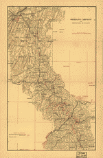
- Camp McDonald; a school of Instruction for the 4th Brigade Georgia Volunteers
- Description
-
Scale 1:2400.
-
LC Civil War Maps (2nd ed.), 149
-
"Lithographed and sold for the benefit of the Georgia volunteers."
-
Pictorial map showing parade grounds, tents, buildings, hospitals, streets, relief by hachures, and the names of principal officers.
-
"The Georgia Military Institute was organized at Marietta, Georgia, in 1851, by Colonel A. V. Brumby; chartered at the session of the General Assembly in the winter of 1851-1852, and modeled after the U.S. Military Academy at West Point. During the war between the states Camp McDonald was established, including the Georgia Military Institute grounds and extending to Big Shanty (now called Kennsaw). Here recruits for the Confederate army were drilled by the cadets and new regiments organized. During the campaign from Dalton to the sea in 1864 the Georgia Military Institute cadets served with great credit. Camp McDonald was destroyed by Sherman and the school was never revived.-Joseph Tyrone Derry."
-
Description derived from published bibliography.
-
Available also through the Library of Congress web site as raster image.
-
1 map, col., 33 x 54 cm.
- Creator
- McClellan, I. B.
- Created Published
-
Atlanta, c1917.
- Subject Headings
-
-
Camp McDonald (Ga.)--History--Civil War, 1861-1865
-
-
Confederate States of America.--Army.--Georgia Infantry Brigade.
-
-
United States--Georgia--Camp McDonald.
- Notes
-
-
Scale 1:2400.
-
-
LC Civil War Maps (2nd ed.), 149
-
-
"Lithographed and sold for the benefit of the Georgia volunteers."
-
-
Pictorial map showing parade grounds, tents, buildings, hospitals, streets, relief by hachures, and the names of principal officers.
-
-
"The Georgia Military Institute was organized at Marietta, Georgia, in 1851, by Colonel A. V. Brumby; chartered at the session of the General Assembly in the winter of 1851-1852, and modeled after the U.S. Military Academy at West Point. During the war between the states Camp McDonald was established, including the Georgia Military Institute grounds and extending to Big Shanty (now called Kennsaw). Here recruits for the Confederate army were drilled by the cadets and new regiments organized. During the campaign from Dalton to the sea in 1864 the Georgia Military Institute cadets served with great credit. Camp McDonald was destroyed by Sherman and the school was never revived.-Joseph Tyrone Derry."
-
-
Description derived from published bibliography.
-
-
Available also through the Library of Congress web site as raster image.
- Medium
-
1 map, col., 33 x 54 cm.
- Call Number
-
G3924.K4:2C3S5 1917 .M4
- Repository
-
Library of Congress Geography and Map Division Washington, D.C. 20540-4650 dcu
- Digital Id
-
g3924k cw0149000 http://hdl.loc.gov/loc.gmd/g3924k.cw0149000
- Library of Congress Catalog Number
- 99447165
Rights & Access
The maps in the Map Collections materials were either published prior to 1922, produced by the United States government, or both (see catalogue records that accompany each map for information regarding date of publication and source). The Library of Congress is providing access to these materials for educational and research purposes and is not aware of any U.S. copyright protection (see Title 17 of the United States Code) or any other restrictions in the Map Collection materials.
Note that the written permission of the copyright owners and/or other rights holders (such as publicity and/or privacy rights) is required for distribution, reproduction, or other use of protected items beyond that allowed by fair use or other statutory exemptions. Responsibility for making an independent legal assessment of an item and securing any necessary permissions ultimately rests with persons desiring to use the item.
More about Copyright and other Restrictions
For guidance about compiling full citations consult Citing Primary Sources.
Part of...
-
Civil War Maps
[2281]
-
Military Battles And Campaigns Cartographic Items
[3867]
-
Geography And Maps Division
[60803]
-
American Memory
[1121009]
More maps like this
-
 Plan of Andersonville Prison or "Camp Sumter," April, 1864.
Contributor:
Sneden, Robert Knox
Site:
American Memory-cultural
Original Format:
Map
Date:
1861
Plan of Andersonville Prison or "Camp Sumter," April, 1864.
Contributor:
Sneden, Robert Knox
Site:
American Memory-cultural
Original Format:
Map
Date:
1861
-
 "Camp Lawton" at Millen, Georgia : about 8,600 prisoners confined here 14th November 1864.
Contributor:
Sneden, Robert Knox
Site:
American Memory-cultural
Original Format:
Map
Date:
1861
"Camp Lawton" at Millen, Georgia : about 8,600 prisoners confined here 14th November 1864.
Contributor:
Sneden, Robert Knox
Site:
American Memory-cultural
Original Format:
Map
Date:
1861
-
 Map showing route taken by U.S. prisoners of war, Feby. 1864, when sent from Richmond, Va., to Andersonville, Georgia.
Contributor:
Sneden, Robert Knox
Site:
American Memory-cultural
Original Format:
Map
Date:
1861
Map showing route taken by U.S. prisoners of war, Feby. 1864, when sent from Richmond, Va., to Andersonville, Georgia.
Contributor:
Sneden, Robert Knox
Site:
American Memory-cultural
Original Format:
Map
Date:
1861
-
 [Map of South Carolina, Georgia, Alabama, and Tennessee.]
Contributor:
Sneden, Robert Knox
Site:
American Memory-cultural
Original Format:
Map
Date:
1861
[Map of South Carolina, Georgia, Alabama, and Tennessee.]
Contributor:
Sneden, Robert Knox
Site:
American Memory-cultural
Original Format:
Map
Date:
1861
-
 2nd attack on Fort McAllister on the Ogeechee River, Georgia
Contributor:
Sneden, Robert Knox
Site:
American Memory-cultural
Original Format:
Map
Date:
1863
2nd attack on Fort McAllister on the Ogeechee River, Georgia
Contributor:
Sneden, Robert Knox
Site:
American Memory-cultural
Original Format:
Map
Date:
1863
-
 Plan of Andersonville Prison, Sumter Co., Georgia.
Contributor:
Sneden, Robert Knox
Site:
American Memory-cultural
Original Format:
Map
Date:
1861
Plan of Andersonville Prison, Sumter Co., Georgia.
Contributor:
Sneden, Robert Knox
Site:
American Memory-cultural
Original Format:
Map
Date:
1861
-
 The State of Georgia, Civil War Centennial, 1864 : showing the major campaign areas and engagement sites of the Union and Confederate armies /
Contributor:
Georgia. State Highway Dept
Site:
American Memory-cultural, Main Catalog
Original Format:
Map
Date:
1964
View catalog record
The State of Georgia, Civil War Centennial, 1864 : showing the major campaign areas and engagement sites of the Union and Confederate armies /
Contributor:
Georgia. State Highway Dept
Site:
American Memory-cultural, Main Catalog
Original Format:
Map
Date:
1964
View catalog record
-
 Lloyd's topographical map of Georgia from state surveys before the war showing railways, stations, villages, mills, &c.
Contributor:
Lloyd, James T.
Site:
American Memory-cultural, Main Catalog
Original Format:
Map
Date:
1864
View catalog record
Lloyd's topographical map of Georgia from state surveys before the war showing railways, stations, villages, mills, &c.
Contributor:
Lloyd, James T.
Site:
American Memory-cultural, Main Catalog
Original Format:
Map
Date:
1864
View catalog record
-
 The State of Georgia, showing the major campaign areas and engagement sites of the War between the States, 1861-1865.
Contributor:
Smith, J. Harmon
Site:
American Memory-cultural, Main Catalog
Original Format:
Map
Date:
1961
View catalog record
The State of Georgia, showing the major campaign areas and engagement sites of the War between the States, 1861-1865.
Contributor:
Smith, J. Harmon
Site:
American Memory-cultural, Main Catalog
Original Format:
Map
Date:
1961
View catalog record
-
 [Troop positions in Georgia].
Site:
American Memory-cultural, Main Catalog
Original Format:
Map
Date:
1864
View catalog record
[Troop positions in Georgia].
Site:
American Memory-cultural, Main Catalog
Original Format:
Map
Date:
1864
View catalog record
-
 Lloyd's Topographical map of Georgia from state surveys before the war showing railways, stations, villages, mills, &c. /
Contributor:
Lloyd, James T.
Site:
American Memory-cultural, Main Catalog
Original Format:
Map
Date:
1864
View catalog record
Lloyd's Topographical map of Georgia from state surveys before the war showing railways, stations, villages, mills, &c. /
Contributor:
Lloyd, James T.
Site:
American Memory-cultural, Main Catalog
Original Format:
Map
Date:
1864
View catalog record
-
 Georgia.
Contributor:
Sneden, Robert Knox
Site:
American Memory-cultural
Original Format:
Map
Date:
1861
Georgia.
Contributor:
Sneden, Robert Knox
Site:
American Memory-cultural
Original Format:
Map
Date:
1861
-
 Map illustrating the first epoch of the Atlanta Campaign : embracing the region from the Tennessee River to the Oostanaula River, showing the positions held ...
Contributor:
Ruger, Edward
Site:
American Memory-cultural, Main Catalog
Original Format:
Map
Date:
1974
View catalog record
Map illustrating the first epoch of the Atlanta Campaign : embracing the region from the Tennessee River to the Oostanaula River, showing the positions held ...
Contributor:
Ruger, Edward
Site:
American Memory-cultural, Main Catalog
Original Format:
Map
Date:
1974
View catalog record
-
 "Atlanta campaign," left wing 16th Army Corps., May 4th to Sept. 8th, 1864 : Maj. Genl. G.M. Dodge, comdg., Genls. Corse and Burke, comdg. divisions ...
Contributor:
Bell, C. J.
Site:
American Memory-cultural, Main Catalog
Original Format:
Map
Date:
1890
View catalog record
"Atlanta campaign," left wing 16th Army Corps., May 4th to Sept. 8th, 1864 : Maj. Genl. G.M. Dodge, comdg., Genls. Corse and Burke, comdg. divisions ...
Contributor:
Bell, C. J.
Site:
American Memory-cultural, Main Catalog
Original Format:
Map
Date:
1890
View catalog record
-
 Sherman's campaign from Chattanooga to Atlanta [1864]
Contributor:
Rhodes, James Ford
Site:
American Memory-cultural, Main Catalog
Original Format:
Map
Date:
1864
View catalog record
Sherman's campaign from Chattanooga to Atlanta [1864]
Contributor:
Rhodes, James Ford
Site:
American Memory-cultural, Main Catalog
Original Format:
Map
Date:
1864
View catalog record
-
 Map of army operations Atlanta campaign between Cassville and Mariette and vicinity
Contributor:
Western and Atlantic Railroad Company
Site:
American Memory-cultural, Main Catalog
Original Format:
Map
Date:
1864
View catalog record
Map of army operations Atlanta campaign between Cassville and Mariette and vicinity
Contributor:
Western and Atlantic Railroad Company
Site:
American Memory-cultural, Main Catalog
Original Format:
Map
Date:
1864
View catalog record
You might also like
-
 Two boys in the Civil War and after
Contributor:
Houghton, W. R.
Site:
American Memory-cultural
Original Format:
Book
Date:
1912
Two boys in the Civil War and after
Contributor:
Houghton, W. R.
Site:
American Memory-cultural
Original Format:
Book
Date:
1912
-
War stories and school-day incidents for the children
Contributor:
Zettler, B. M.
Site:
American Memory-cultural
Original Format:
Book
Date:
1912
-
 The war-time journal of a Georgia girl, 1864-1865,
Contributor:
Andrews, Eliza Frances
Site:
Main Catalog
Original Format:
Book
Date:
1908
The war-time journal of a Georgia girl, 1864-1865,
Contributor:
Andrews, Eliza Frances
Site:
Main Catalog
Original Format:
Book
Date:
1908
-
Recollections of a naval life including the cruises of the Confederate States steamers, "Sumter" and "Alabama" /
Contributor:
Kell, John McIntosh
Site:
American Memory-cultural
Original Format:
Book
Date:
1900
-
Paroles of the Army of northern Virginia, R. E. Lee, gen., C. S. A., commanding, surrendered at Appomattox C. H., Va., April 9, 1865, to ...
Contributor:
Confederate States of America. Army. Dept. of Northern Virginia
Site:
Main Catalog
Original Format:
Book
Date:
1865-04-09
-
Boy soldiers of the confederacy,
Contributor:
Hull, Susan Rebecca Thompson
Site:
Main Catalog
Original Format:
Book
Date:
1905