Map
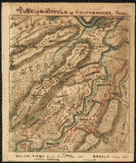
Battle-field of Chickamauga. [Sept 18-20, 1863].

| Format |
Map |
|---|---|
| Contributors |
Wells, Jacob |
| Dates |
1887 |
| Location |
Chickamauga Georgia United States |
| Language |
English |
| Subjects |
Battle Of Chickamauga Chickamauga (Ga.), Battle Of Ga Georgia United States |
- Title
- Battle-field of Chickamauga. [Sept 18-20, 1863].
- Description
-
Scale ca. 1:84,000.
-
LC Civil War Maps (2nd ed.), 163
-
From Century illustrated monthly magazine, v. 33, April 1887. p. 954.
-
Indicates by symbols the "positions, evening of Sept. 18, 1863," "direction of lines of battle, Sept. 19th," "first lines of battle, Sept. 20th," "last lines of battle, Sept. 20th," "positions of Union troops after the battle," and positions of the cavalry. Map also includes roads, rivers, fords, bridges, relief by hachures, and houses.
-
Description derived from published bibliography.
-
Available also through the Library of Congress web site as raster image.
-
1 map, 14 x 22 cm.
- Creator
- Wells, Jacob.
- Created Published
-
[S.l.], 1887.
- Subject Headings
-
-
Chickamauga, Battle of, Ga., 1863
-
-
United States--Georgia--Chickamauga.
-
-
Chickamauga (Ga.), Battle of, 1863.
- Notes
-
-
Scale ca. 1:84,000.
-
-
LC Civil War Maps (2nd ed.), 163
-
-
From Century illustrated monthly magazine, v. 33, April 1887. p. 954.
-
-
Indicates by symbols the "positions, evening of Sept. 18, 1863," "direction of lines of battle, Sept. 19th," "first lines of battle, Sept. 20th," "last lines of battle, Sept. 20th," "positions of Union troops after the battle," and positions of the cavalry. Map also includes roads, rivers, fords, bridges, relief by hachures, and houses.
-
-
Description derived from published bibliography.
-
-
Available also through the Library of Congress web site as raster image.
- Medium
-
1 map, 14 x 22 cm.
- Call Number
-
G3924.C5S5 1887 .W4
- Repository
-
Library of Congress Geography and Map Division Washington, D.C. 20540-4650 dcu
- Digital Id
-
g3924c cw0163000 http://hdl.loc.gov/loc.gmd/g3924c.cw0163000
- Library of Congress Catalog Number
- 99447326
Rights & Access
The maps in the Map Collections materials were either published prior to 1922, produced by the United States government, or both (see catalogue records that accompany each map for information regarding date of publication and source). The Library of Congress is providing access to these materials for educational and research purposes and is not aware of any U.S. copyright protection (see Title 17 of the United States Code) or any other restrictions in the Map Collection materials.
Note that the written permission of the copyright owners and/or other rights holders (such as publicity and/or privacy rights) is required for distribution, reproduction, or other use of protected items beyond that allowed by fair use or other statutory exemptions. Responsibility for making an independent legal assessment of an item and securing any necessary permissions ultimately rests with persons desiring to use the item.
More about Copyright and other Restrictions
For guidance about compiling full citations consult Citing Primary Sources.
Part of...
-
Civil War Maps
[2281]
-
Military Battles And Campaigns Cartographic Items
[3867]
-
Geography And Maps Division
[60803]
-
American Memory
[1121009]
More maps like this
-
 Map of the Chickamauga battle-field, Georgia
Contributor:
Wood, W. A.
Site:
American Memory-cultural, Main Catalog
Original Format:
Map
Date:
1895
View catalog record
Map of the Chickamauga battle-field, Georgia
Contributor:
Wood, W. A.
Site:
American Memory-cultural, Main Catalog
Original Format:
Map
Date:
1895
View catalog record
-
 Atlas of Chickamauga, Chattanooga, and vicinity.
Contributor:
United States. Chickamauga and Chattanooga National Park Commission
Site:
American Memory-cultural, Main Catalog
Original Format:
Map
Date:
1901
View catalog record
Atlas of Chickamauga, Chattanooga, and vicinity.
Contributor:
United States. Chickamauga and Chattanooga National Park Commission
Site:
American Memory-cultural, Main Catalog
Original Format:
Map
Date:
1901
View catalog record
-
 Battle map of Chickamauga, Georgia. Saturday 19 [and] Sunday, 20 September 1863. Map of the Chattanooga battle-fields, November, 1863. Orchard Knob, 23d, Lookout Mountain, 24th, ...
Contributor:
Norwood, Charles W.
Site:
American Memory-cultural, Main Catalog
Original Format:
Map
Date:
1898
View catalog record
Battle map of Chickamauga, Georgia. Saturday 19 [and] Sunday, 20 September 1863. Map of the Chattanooga battle-fields, November, 1863. Orchard Knob, 23d, Lookout Mountain, 24th, ...
Contributor:
Norwood, Charles W.
Site:
American Memory-cultural, Main Catalog
Original Format:
Map
Date:
1898
View catalog record
-
 Atlas of the battlefields of Chickamauga, Chattanooga and vicinity.
Contributor:
United States. Chickamauga and Chattanooga National Park Commission
Site:
American Memory-cultural, Main Catalog
Original Format:
Map
Date:
1896
View catalog record
Atlas of the battlefields of Chickamauga, Chattanooga and vicinity.
Contributor:
United States. Chickamauga and Chattanooga National Park Commission
Site:
American Memory-cultural, Main Catalog
Original Format:
Map
Date:
1896
View catalog record
-
 Chickamauga Battlefield /
Contributor:
United States. National Park Service
Site:
American Memory-cultural, Main Catalog
Original Format:
Map
Date:
1973
View catalog record
Chickamauga Battlefield /
Contributor:
United States. National Park Service
Site:
American Memory-cultural, Main Catalog
Original Format:
Map
Date:
1973
View catalog record
-
 Battle of Chickamauga, Ga., Sept. 19 and 20, 1863 /
Contributor:
Morris, Walter J.
Site:
American Memory-cultural, Main Catalog
Original Format:
Map
Date:
1863
View catalog record
Battle of Chickamauga, Ga., Sept. 19 and 20, 1863 /
Contributor:
Morris, Walter J.
Site:
American Memory-cultural, Main Catalog
Original Format:
Map
Date:
1863
View catalog record
-
 Chickamauga battlefield. [Sept 19-20, 1863]
Contributor:
McElroy, Joseph C.
Site:
American Memory-cultural, Main Catalog
Original Format:
Map
Date:
1895
View catalog record
Chickamauga battlefield. [Sept 19-20, 1863]
Contributor:
McElroy, Joseph C.
Site:
American Memory-cultural, Main Catalog
Original Format:
Map
Date:
1895
View catalog record
-
 Chickamauga battlefield. Accompanies The battle of Chickamauga. Historical map and guide book.
Contributor:
McElroy, Joseph C.
Site:
American Memory-cultural, Main Catalog
Original Format:
Map
Date:
1895
View catalog record
Chickamauga battlefield. Accompanies The battle of Chickamauga. Historical map and guide book.
Contributor:
McElroy, Joseph C.
Site:
American Memory-cultural, Main Catalog
Original Format:
Map
Date:
1895
View catalog record
-
 The Battlefield of Chicamauga Fought the 19th and 20th of Septr 1863.
Contributor:
Sneden, Robert Knox
Site:
American Memory-cultural
Original Format:
Map
Date:
1861
The Battlefield of Chicamauga Fought the 19th and 20th of Septr 1863.
Contributor:
Sneden, Robert Knox
Site:
American Memory-cultural
Original Format:
Map
Date:
1861
-
 Plan of the Battle of Chickamauga, Tenn.
Contributor:
Sneden, Robert Knox
Site:
American Memory-cultural
Original Format:
Map
Date:
1861
Plan of the Battle of Chickamauga, Tenn.
Contributor:
Sneden, Robert Knox
Site:
American Memory-cultural
Original Format:
Map
Date:
1861
-
 Genl. Thomas' new position 20th Septr. 3 p.m.
Contributor:
Sneden, Robert Knox
Site:
American Memory-cultural
Original Format:
Map
Date:
1861
Genl. Thomas' new position 20th Septr. 3 p.m.
Contributor:
Sneden, Robert Knox
Site:
American Memory-cultural
Original Format:
Map
Date:
1861
-
 Battle of Fredericksburg. Dec. 13, 1862.
Contributor:
Wells, Jacob
Site:
American Memory-cultural, Main Catalog
Original Format:
Map
Date:
1862
View catalog record
Battle of Fredericksburg. Dec. 13, 1862.
Contributor:
Wells, Jacob
Site:
American Memory-cultural, Main Catalog
Original Format:
Map
Date:
1862
View catalog record
-
 Map of the battle of Malvern Hill, showing, approximately, positions of brigades and batteries. [July 1, 1862].
Contributor:
Wells, Jacob
Site:
American Memory-cultural, Main Catalog
Original Format:
Map
Date:
1885-01-01
View catalog record
Map of the battle of Malvern Hill, showing, approximately, positions of brigades and batteries. [July 1, 1862].
Contributor:
Wells, Jacob
Site:
American Memory-cultural, Main Catalog
Original Format:
Map
Date:
1885-01-01
View catalog record
-
 [Map of the battle field of Gaines's Mill, showing approximately the positions of infantry and artillery engaged /
Contributor:
Wells, Jacob
Site:
American Memory-cultural, Main Catalog
Original Format:
Map
Date:
1885
View catalog record
[Map of the battle field of Gaines's Mill, showing approximately the positions of infantry and artillery engaged /
Contributor:
Wells, Jacob
Site:
American Memory-cultural, Main Catalog
Original Format:
Map
Date:
1885
View catalog record
-
 [Plan of the battle of Mechanicsville, June 26, 1862].
Contributor:
Wells, Jacob
Site:
American Memory-cultural, Main Catalog
Original Format:
Map
Date:
1885-01-01
View catalog record
[Plan of the battle of Mechanicsville, June 26, 1862].
Contributor:
Wells, Jacob
Site:
American Memory-cultural, Main Catalog
Original Format:
Map
Date:
1885-01-01
View catalog record
-
 Map of the battle of Frayser's Farm (Charles City cross roads or Glendale), June 30, 1862, showing approximate positions of Union and Confederate troops. Also ...
Contributor:
Wells, Jacob
Site:
American Memory-cultural, Main Catalog
Original Format:
Map
Date:
1862-06-30
View catalog record
Map of the battle of Frayser's Farm (Charles City cross roads or Glendale), June 30, 1862, showing approximate positions of Union and Confederate troops. Also ...
Contributor:
Wells, Jacob
Site:
American Memory-cultural, Main Catalog
Original Format:
Map
Date:
1862-06-30
View catalog record
You might also like
-
 Chicamauga (i.e. Chickamauga) battlefield
Site:
Prints & Photographs, Main Catalog
Original Format:
Photo, Print, Drawing
Date:
1861
View catalog record
Chicamauga (i.e. Chickamauga) battlefield
Site:
Prints & Photographs, Main Catalog
Original Format:
Photo, Print, Drawing
Date:
1861
View catalog record
-
 Grand Review, U.S.V.I., Chickamauga, Ga.
Contributor:
Judd, A. W.
Site:
Prints & Photographs, Main Catalog
Original Format:
Photo, Print, Drawing
Date:
1898
View catalog record
Grand Review, U.S.V.I., Chickamauga, Ga.
Contributor:
Judd, A. W.
Site:
Prints & Photographs, Main Catalog
Original Format:
Photo, Print, Drawing
Date:
1898
View catalog record
-
 Attack on the center. Chickamauga
Contributor:
Waud, Alfred R. (Alfred Rudolph), Waud, Alfred R.
Site:
Prints & Photographs, Main Catalog
Original Format:
Photo, Print, Drawing
Date:
1863
View catalog record
Attack on the center. Chickamauga
Contributor:
Waud, Alfred R. (Alfred Rudolph), Waud, Alfred R.
Site:
Prints & Photographs, Main Catalog
Original Format:
Photo, Print, Drawing
Date:
1863
View catalog record
-
 Lee and Gordon's Mills [i.e. Mill], Chickamauga, Ga.
Contributor:
Detroit Publishing Co
Site:
Prints & Photographs
Original Format:
Photo, Print, Drawing
Date:
1905
Lee and Gordon's Mills [i.e. Mill], Chickamauga, Ga.
Contributor:
Detroit Publishing Co
Site:
Prints & Photographs
Original Format:
Photo, Print, Drawing
Date:
1905
-

 [Maps and diagrams of the Battle of Chickamauga, Ga. Sep 19 - 63]
Contributor:
Waud, Alfred R.
Site:
Main Catalog
Original Format:
Photo, Print, Drawing
Date:
1863
[Maps and diagrams of the Battle of Chickamauga, Ga. Sep 19 - 63]
Contributor:
Waud, Alfred R.
Site:
Main Catalog
Original Format:
Photo, Print, Drawing
Date:
1863
-
 [The first gun at Chickamauga]
Contributor:
Waud, Alfred R. (Alfred Rudolph), Waud, Alfred R.
Site:
Prints & Photographs, Main Catalog
Original Format:
Photo, Print, Drawing
Date:
1863
View catalog record
[The first gun at Chickamauga]
Contributor:
Waud, Alfred R. (Alfred Rudolph), Waud, Alfred R.
Site:
Prints & Photographs, Main Catalog
Original Format:
Photo, Print, Drawing
Date:
1863
View catalog record