![[December 21, 1944], HQ Twelfth Army Group situation map.](https://cybercemetery.unt.edu/archive/oilspill/20121228213626im_/http://www.loc.gov/collections/static/world-war-ii-maps-military-situation-maps-from-1944-to-1945/images/ict21200.jpg)
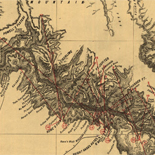
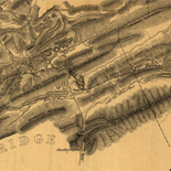
![[Rough sketch of the Rich Mountain battle area extending from Beverly, W. Va. to Clarksburg].](https://cybercemetery.unt.edu/archive/oilspill/20121228213626im_/http://www.loc.gov/collections/static/hotchkiss-maps/images/cwh00078.jpg)

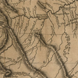
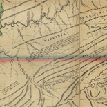
![[Sketch of the battles of Chancellorsville, Salem Church, and Fredericksburg], May 2, 3, and 4, 1863](https://cybercemetery.unt.edu/archive/oilspill/20121228213626im_/http://www.loc.gov/collections/static/civil-war-maps/images/cwh00129.jpg)
![[Coast of Maine from Frenchmans Bay to Mosquito Harbor].](https://cybercemetery.unt.edu/archive/oilspill/20121228213626im_/http://www.loc.gov/collections/static/american-revolutionary-war-maps/images/np000011.jpg)
Results
-

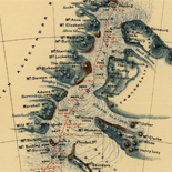
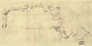
[Union troop positions at Peach Tree Creek, Georgia, July 20, 1864].
Shows Union camps and troop positions in north Atlanta.
Site: American Memory-cultural - Main Catalog Original Format: Map Date: 1864-07-20 View catalog record -

Map of Marietta and vicinity. [June 1864]
Scale ca. 1:185,000.
Contributor: Western and Atlantic Railroad Company Site: American Memory-cultural - Main Catalog Original Format: Map Date: 1864 View catalog record -

Camp McDonald; a school of Instruction for the 4th Brigade Georgia Volunteers
Scale 1:2400.
Contributor: McClellan, I. B. Site: American Memory-cultural - Main Catalog Original Format: Map Date: 1917 View catalog record -

[Fortifications west of Dalton, Georgia].
Relief shown by hachures.
Site: American Memory-cultural - Main Catalog Original Format: Map Date: 1864 View catalog record -

[Union troop positions northwest of Marietta, Georgia, June? 1864].
Relief shown by hachures.
Site: American Memory-cultural - Main Catalog Original Format: Map Date: 1864 View catalog record -

Works at eastern point of Whitmarsh Island [and] bastion on the line of defences [sic] across Whitmarsh Island.
Shows fortification of Savannah, Georgia.
Site: American Memory-cultural - Main Catalog Original Format: Map Date: 1864 View catalog record -

[Map of the Union troop positions southwest of Marietta, Georgia, June 10-July 3, 1864].
Title and date from Stephenson's Civil War maps, 1989.
Site: American Memory-cultural - Main Catalog Original Format: Map Date: 1864-07-03 View catalog record -

Andersonville Prison, Georgia in July 1864.
Lower margin of the map: "Whole Content of Stockade 25 1/2 acres, including swamp. Number of Prisoners July 1st."
Contributor: Sneden, Robert Knox Site: American Memory-cultural Original Format: Map Date: 1861 -

Map[s] illustrating the military operations of the Atlanta campaign ... 1864 /
Shows Union Army lines of march, dates, troop positions, and campsites in northwestern Georgia between Chattanooga and Atlanta.
Site: American Memory-cultural - Main Catalog Original Format: Map Date: 1874 View catalog record -
Map[s] illustrating the military operations of the Atlanta campaign ... 1864 /
Relief shown by hachures.
Site: American Memory-cultural - Main Catalog Original Format: Map Date: 1875 View catalog record -
[Map of the Etowah River from Rome to Cartersville, Georgia].
Shows fords, bridges, and ferries across the Etowah River spanning southeastern Floyd County and southwestern Bartow County, Georgia. Fortifications shown at Caldwell Ford, Bartow County.
Site: American Memory-cultural - Main Catalog Original Format: Map Date: 1864 View catalog record -

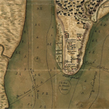
Plan of Andersonville Prison or "Camp Sumter," April, 1864.
Bottom of the map: "The 1st detachment of Union Prisoners arrived Feby. 15th."
Contributor: Sneden, Robert Knox Site: American Memory-cultural Original Format: Map Date: 1861 -

Fort McAllister : [Georgia].
Relief shown by hachures.
Site: American Memory-cultural - Main Catalog Original Format: Map Date: 1864 View catalog record -

Columbus, Ga.
Shows fortifications near Columbus, Georgia.
Site: American Memory-cultural - Main Catalog Original Format: Map Date: 1864 View catalog record -

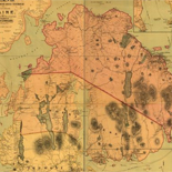
Lloyd's topographical map of Georgia from state surveys before the war showing railways, stations, villages, mills, &c.
Scale ca. 1:580,000.
Contributor: Lloyd, James T. Site: American Memory-cultural - Main Catalog Original Format: Map Date: 1864 View catalog record -

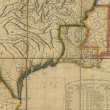
Map of the cost [sic] of Georgia & Florida.
Scale 1:253,440; 1/4 in. to 1 mile.
Site: American Memory-cultural - Main Catalog Original Format: Map Date: 1863 View catalog record -

Map illustrating the defence [sic] of Savannah, Ga. and the operations resulting in its capture by the army commanded by Maj. Genl. W.T. Sherman, Dec. ...
Shows fortifications, headquarters, and location and dates of battles.
Contributor: Poe, O. M. Site: American Memory-cultural - Main Catalog Original Format: Map View catalog record -

[Union troop positions east of Dallas, Georgia, May 25-June 5, 1864].
Shows Union troop positions in eastern Paulding County, Georgia.
Site: American Memory-cultural - Main Catalog Original Format: Map Date: 1864-06-05 View catalog record -

The State of Georgia, showing the major campaign areas and engagement sites of the War between the States, 1861-1865.
Scale ca. 1:960,000.
Contributor: Smith, J. Harmon Site: American Memory-cultural - Main Catalog Original Format: Map Date: 1961 View catalog record -

Plan of Camp Lawton, or the rebel prison near Millen, Georgia ... November 1864.
"From plans made by R.K. Sneden 40th NY Vols. while a prisoner of war."--Page caption.
Contributor: Sneden, Robert Knox Site: American Memory-cultural Original Format: Map Date: 1864
Refine your search
Original Format
- Map