
The Hispanic and Portuguese World
ENCOUNTERS IN AMERICA
In October 1492 Christopher Columbus and his crew reached the Bahamas. From that time forward Europeans and the people living in the continents of the Western Hemisphere now known to us as the Americas, North and South, came into permanent contact. That encounter took numerous forms, generating responses from various sides. These reactions depended as much on the circumstances and world view of indigenous groups as they did on European objectives and values.
 Hernando Cortés and the Spanish Soldiers Confront
the
Indians. In Fray Diego Durán. La Historia antigua de la Nueva
España. 1585 [Manuscript facsimile, ca. nineteenth century]. The
fierce confrontation between the Spaniards under Cortés and the
followers of Moctezuma received full treatment in Father's
Durán's illustrated history of Mexico, compiled shortly after the
early sixteenth-century conquest. The Mexica (Aztec) peoples
confronted a powerful Spanish force supplemented by a sizable
number of allies from the area surrounding Tenochtitlán [later
named Mexico City] during the 1519-1521 campaigns. Durán's
informants have skillfully distinguished Indian peoples from the
European invaders, with a ghostly white image representing the
Spanish. The Library of Congress acquired this extremely rare
facsimile manuscript in the Peter Force Collection purchase in
1867. (Peter Force Collection, Manuscript Division)
Hernando Cortés and the Spanish Soldiers Confront
the
Indians. In Fray Diego Durán. La Historia antigua de la Nueva
España. 1585 [Manuscript facsimile, ca. nineteenth century]. The
fierce confrontation between the Spaniards under Cortés and the
followers of Moctezuma received full treatment in Father's
Durán's illustrated history of Mexico, compiled shortly after the
early sixteenth-century conquest. The Mexica (Aztec) peoples
confronted a powerful Spanish force supplemented by a sizable
number of allies from the area surrounding Tenochtitlán [later
named Mexico City] during the 1519-1521 campaigns. Durán's
informants have skillfully distinguished Indian peoples from the
European invaders, with a ghostly white image representing the
Spanish. The Library of Congress acquired this extremely rare
facsimile manuscript in the Peter Force Collection purchase in
1867. (Peter Force Collection, Manuscript Division)
The interactions among groups have produced complex relationships. Varying forms of resistance and adaptation among Indian, African, Asian, and European peoples occurred throughout the region, and that process of evolution in the Americas is strongly reflected in the Library of Congress collections.
The Manuscript Division possesses an extensive body of photoreproduced documents from foreign archives acquired through special copying programs during the twentieth century. Both colonial and independence period materials for the Americas, including materials from Spain's Real Academia de la Historia, Archivo Histórico General, Biblioteca del Palacio, Biblioteca Nacional, Archivo General de Indias, Biblioteca Colombina, Archivo General de Simancas, Biblioteca Pública (Toledo) and the national archives of Argentina, Chile, Cuba, Puerto Rico, Venezuela, the Vatican (Peruvian dispatches, 1603-1875), Great Britain (British Foreign Office Papers on Panama, 1827-1919), France, and several Mexican archives, including the Archivo General de la Nación, Archivo de la Secretaría de Relaciones Exteriores, Biblioteca Nacional, Biblioteca Benjamín Franklin, Archivo General de Mérida, the Archive of the Bishop of Mérida, the Museo Nacional de Arqueología, Historia y Etnografía, and the Banco de México are found there. Photocopied records on the Luso-Hispanic world from these same archives are found in the collections of the Geography and Map, Rare Book and Special Collections, and the Prints and Photographs Divisions.
Invaluable as source materials, these copied documents provide primary information on the Americas from the Spanish colonial administration in Chile, Charcas, Mexico, Guatemala, Philippines, Nueva Granada, Santo Domingo, Cuba, and Spanish administrative locations in what is now the United States. Among these documents are found official correspondence, local reports, maps, cryptic messages, literary tracts, and censuses. While these substantial and invaluable materials for the most part provide coverage for Spanish administration in the United States, both in its southeastern and southwestern regions, additional rolls of microfilm contain documents on Mexico. The publication The Hispanic World 1492-1898; El mundo hispánico 1492-1898 (1994) guides one into the treasures in the Spanish archival portion of this copied collection in the Manuscript, Geography and Map, Prints and Photographs, and Rare Book and Special Collections Divisions.
In the Rare Book and Special Collections Division are some four hundred early publications printed in Spanish American colonies, 1544-1820. This SPANISH AMERICAN IMPRINTS COLLECTION contains original works primarily from Mexico, Peru, and Guatemala, although imprints from other areas appear. These works include some of the earliest publications printed in the Western Hemisphere. One can find in the collection Indian language grammars and vocabularies, general histories, religious publications, statutes of the Inquisition, and juridical and political writings. Among the collection's treasures are a 1544 copy of Bishop Juan de Zumárraga's Doctrina Breve and original editions by Horacio Carochi, Pablo José de Arriaga, Maturino Gilberti, Luís Lopez Juan Bautista, Juan de Grijalva, Alonso de Molina, Bishop Juan de Palafox y Mendoza, Pedro de Peralta Barnuevo Rocha y Benavides, and Carlos de Sigüenza y Góngora. In the Law Library is found the 1563 Mexican Cedulario de Puga, the first law book printed in the Americas. The Music Division has the 1576 Mexican imprint by Pedro Ocharte, of the graduale dominicale, the Library's earliest printed American book of music.
The LATIN AMERICAN IMPRINTS BEFORE 1800 COLLECTION, selected from the bibliographical surveys of the Chilean bibliophile José Toribio Medina, is available in the Microform Reading Room on 248 reels of microfilm. Among the themes represented are those on politics, religion, literature and education as well as histories, relaciones, descriptive and practical works, and a variety of government publications.
The library of Peter Force, a collection of more than 65,000 manuscripts, books, newspapers, and maps on American history, early American imprints, and incunabula, was purchased by act of Congress in 1867. In the course of preparing his Documentary History of the American Revolution, this Washington publisher and politician (1790-1868) assembled what was probably the largest private collection in the United States of printed and manuscript sources on American history. Among the items is a twenty-five- volume Hispanic collection, consisting primarily of manuscript copies of works about the Americas by various Spanish writers, including Bartolomé de las Casas. Items of particular value and use are Fray Diego Durán's Historia Antigua de la Nueva España (1585) which is a history of the native peoples of Mexico's Central Valley, a record of their calendar, and other activities; Fray Jerónimo de Alcalá's history of the Tarascan peoples of western Mexico, Relación de...Mechuacan (1537-41); and Mariano Fernández de Echevarría y Veitia's sixteenth- century Historia del origen de las gentes... which includes copies of seven Mexica calendars.
 First page. Epistola de insulis nuper inventis [printed
letter] [Christopher Columbus]. Rome, Stephan Plannck, 1493.
This book contains the first printed European descriptions of the
people and places in America. While homeward bound in mid-
February 1493, Columbus wrote a brief report concerning his
discoveries. He depicts the inhabitants, whom he calls Indians,
as kind and timid, willing to do much for little, and ready to
convert to Christianity. Within six weeks of his arrival in
Europe, a Latin edition of Columbus's letter was printed in Rome
by Stephan Plannck. It was this Latin letter that spread the
news of discovery throughout Europe. The Library's copy of the
Latin edition is the foundation stone of its vast Americana
collection. (Incunable Collection, Rare Book and Special
Collections Division)
First page. Epistola de insulis nuper inventis [printed
letter] [Christopher Columbus]. Rome, Stephan Plannck, 1493.
This book contains the first printed European descriptions of the
people and places in America. While homeward bound in mid-
February 1493, Columbus wrote a brief report concerning his
discoveries. He depicts the inhabitants, whom he calls Indians,
as kind and timid, willing to do much for little, and ready to
convert to Christianity. Within six weeks of his arrival in
Europe, a Latin edition of Columbus's letter was printed in Rome
by Stephan Plannck. It was this Latin letter that spread the
news of discovery throughout Europe. The Library's copy of the
Latin edition is the foundation stone of its vast Americana
collection. (Incunable Collection, Rare Book and Special
Collections Division)
The Rare Book and Special Collections Division houses 5,193 books and manuscripts, containing incunabula and early Americana, donated by John Boyd Thacher (1847-1909), a New York manufacturer and politician. Thacher drew upon this extensive collection for his publications The Continent of America (1896) and Christopher Columbus (1903-1904). It is highlighted by copies of thirty-four early editions of Ptolemy's Geographia, an illustrated 1494 Basel edition of Columbus's 1493 letter on America, three pre-1510 editions of Martin Waldseemüller's Cosmographiae Introductio in which the name America first appears, and the unique 1503 Angelo Trevisan manuscript on Spanish explorations in America (1492-1500) and Portuguese voyages to Brazil and India (1497- 1502).
The Library of Congress has all the major histories of America which describe Spanish and Portuguese conquest and colonization. These range from contemporaries of the early European Age of Discovery such as Pietro Martire d'Anghiera and Gonzalo Fernández de Oviedo to those by travelers in Spanish America in the early colonial period such as Girolamo Benzoni, whose Historia del Mondo Nuovo is present in Italian (1572), French (1579), Latin (1578), German (late sixteenth century), and Dutch (1610) editions.
 The naming of America. In Martin Waldseemüller.
Cosmographiae introductio. St. Dié, 1507. This extremely
rare work contains the first suggestion that the area of
Columbus's discovery be named "America" in honor of Amerigo
Vespucci, who recognized that a "New World," the so-called fourth
part of the world, had been reached through Columbus's voyage.
Before that time, there was no name that collectively identified
the Western Hemisphere. The earlier Spanish explorers referred
to the area as the Indies believing, as did Columbus, that it was
a part of eastern Asia. (Thacher Collection, Rare Book and
Special Collections Division)
The naming of America. In Martin Waldseemüller.
Cosmographiae introductio. St. Dié, 1507. This extremely
rare work contains the first suggestion that the area of
Columbus's discovery be named "America" in honor of Amerigo
Vespucci, who recognized that a "New World," the so-called fourth
part of the world, had been reached through Columbus's voyage.
Before that time, there was no name that collectively identified
the Western Hemisphere. The earlier Spanish explorers referred
to the area as the Indies believing, as did Columbus, that it was
a part of eastern Asia. (Thacher Collection, Rare Book and
Special Collections Division)
There are very many first editions despite their great rarity. The earliest of histories of the Americas, De Orbe Novo, by Pietro Martire de Anghiera is found in its stages of presentation, in 1511, 1524, and 1553 editions. An English translation of the work by Richard Eden, The Decades of the Newe Worlde or West India (1555), and the 1577 reissue by Richard Willis, The historie of travayle into the West and east Indies, are located in the Rare Book and Special Collections Division. The Library of Congress holds Gonzalo Fernández de Oviedo's (1478-1557) 1526 edition of his Natural hystoria delas Indias, the 1535 edition of his Historia general de las Indias, and his 1547 Corónica de las Indias.
 Balsa boat on Lake Titicaca. Black and white photograph.
[ca. 1940]. The form of transportation depicted in this ca. 1940
photograph is time honored in the highlands of Peru and Bolivia.
Images of the balsa, or reed boats of Lake Titicaca appeared in
pre-Inca poetry of the Mochica culture of the Andean region.
(General Geographical Collection, Prints and Photographs
Division)
Balsa boat on Lake Titicaca. Black and white photograph.
[ca. 1940]. The form of transportation depicted in this ca. 1940
photograph is time honored in the highlands of Peru and Bolivia.
Images of the balsa, or reed boats of Lake Titicaca appeared in
pre-Inca poetry of the Mochica culture of the Andean region.
(General Geographical Collection, Prints and Photographs
Division)
Works on the Spanish conquests in America including Francisco López de Gómara's 1553 Historia general de las Indias on Mexico, or Bartolomé de las Casas's Brevissima relación de la destrucción de las Indias (1552) on the Caribbean world, or works by José de Acosta, Francisco de Xerez, Pedro Cieza de León, Agustín de Zárate, and Garcilaso de la Vega on Peru, or by André Thevet and Jean de Léry on Brazil, or by Ulrich Schmidel and Theodor de Bry on Rio de la Plata, or by Nuñez Cabeza de Vaca and Garcilaso de la Vega on Florida and Texas are all found in the Rare Book and Special Collections Division.
The HENRY HARRISSE COLLECTION, in the Library's Rare Book and Special Collections and the Geography and Map Divisions, contains publications, papers, and maps on early American exploration. Perhaps best known for Bibliotheca Americana Vetutissima, a description of over three hundred writings on America published between 1492 and 1551, Harrisse (1829-1910) wrote extensively on Christopher and Ferdinand Columbus, John and Sebastian Cabot, and the early voyages of American exploration.
Through his 1915 bequest, the Library of Congress acquired his personal collection which is in the Rare Book and Special Collections Division. In addition to more than two hundred volumes, the collection preserves correspondence pertaining to Harrisse's research, an original letter by Pietro Martire d'Anghiera, and a circa 1553 manuscript description of a voyage along the northern coast of South America. Among the fourteen rare manuscript maps and one view from the Harrisse bequest in the Geography and Map Division are maps of North and South America, including ones of Habana harbor, Cuba, Hispaniola, and the Bahamas (1639) by Joan Vingboons, cartographer of the Prince of Nassau. Harrisse's study collection of 600 photographs, facsimiles, and tracings of early maps is also in that Division.
Columbus's Book of Privileges in the Manuscript Division is a 1502 manuscript on vellum of the various hereditary grants, charters, and privileges made to Columbus by Fernando and Isabel and the Papal Bulls issued by Alexander VI in May and October 1493. One of the Library's most valuable treasures, the interest attached to this codex is heightened by the fact that it was compiled by public notaries under the personal direction of Columbus shortly before he embarked on his fourth and final voyage to America. The Library's example of the Book of Privileges is one of only three vellum originals; the other originals are located in Genoa and Paris. In 1818 Edward Everett purchased in Florence the eighty-folio-page manuscript on vellum which the Library of Congress purchased from the family in 1897.
For the study of the earliest period in colonial Mexico and Peru, especially the activities of Hernando Cortés and Francisco Pizarro, the HARKNESS COLLECTION, in the Manuscript Division, is an invaluable resource. In 1928 and 1929 Edward Stephen Harkness (1874-1940), an American philanthropist, presented the collection of documents to the Library of Congress.
The 2,939-folio Mexican manuscripts segment relates primarily to the 1566 Cortés-Avila conspiracy to overthrow the government of New Spain and to the affairs of Hernando Cortés and his family between 1525 and 1565. Of particular interest are the confirmation of Cortés's coat of arms and the extremely rare 1531 Huexotzinco Codex, a tribute document on amatl paper, prepared by the indigenous peoples of Huexotzinco.
The character of the 1,405 folios of Peruvian manuscripts in the HARKNESS COLLECTION varies. A great part is composed of original notarial documents (1531-1618). Other documents include royal cédulas (1555-1610), viceregal decrees (1556-1651, 1740) and the minutes and acts of the town councils of Chachapoyas (1538-1545) and San Juan de la Frontera de Guamanga (1539-1547). Forty-eight documents relate to the families of Francisco Pizarro and Diego de Almagro, key figures in the Spanish conquest of Peru. Two undated and anonymous sixteenth- century manuscript charts on vellum of the west coast of South and Central America are in the VELLUM CHART COLLECTION in the Geography and Map Division.
A second major body of 162 manuscripts relating to the history of Spanish America during its colonial period was donated by Hans P. Kraus in 1969. Located in the Manuscript Division, this collection is known as the HANS P. KRAUS COLLECTION OF HISPANIC AMERICAN MANUSCRIPTS. Focusing on colonial Mexico, the KRAUS COLLECTION contains documents on exploration, government, the Inquisition, economic conditions, Indian relations, and the impending loss of land to Anglo-American settlers in Florida. From the archives of Juan de Zumárraga, first bishop of Mexico, there are papers dating from 1527 to 1660 that include the signatures of Emperor Charles V, Isabella of Portugal, Philip II, Juana, and Cardinal García de Loaysa. Other documents pertain to the civil administration in the sixteenth-century Spanish Indies which throw light on the drafting of the New Laws of 1542 and the career of Bartolomé de las Casas. The KRAUS COLLECTION includes documents on the viceregal administration, the history of Spanish Florida, Hernando Alvarado Tezozomoc's chronicle on the history of the Aztec peoples, and on explorations and other activities of Amerigo Vespucci, Giovanni da Verrazzano, Alvar Núñez Cabeza de Vaca, Pedro de Ursúa, and Lope de Aguirre. The HENRY A. MONDAY COLLECTION of Mexican manuscripts and documents (1522-1935) in the Manuscript Division concerns primarily the activities of the Dominican Order in Puebla and Catholic Church documents for colonial Mexico.
The Library's Geography and Map Division has an extremely rich collection of original, printed, and photoreproduced maps of Hispanic and Portuguese America. Among many items in this truly outstanding collection is a copy of Juan de la Cruz Cano y Olmedilla's 1775 official map of South America, other detailed cartographic items for America, a host of individual maps and charts such as those by Francisco Matías Celi, Tomás López, and Juan Enrique de la Rigada, and one of only two extant copies of Diego Gutiérrez's extraordinary 1562 printed map of America, which was given to the Library by Lessing J. Rosenwald. That last map, the largest printed map of America at the time, provides detailed coastal and interior information of the Western Hemisphere. Another rich manuscript map collection, the MAGGS COLLECTION, from the Royal School for Navigation (Cádiz), contains about four hundred eighteenth- and early nineteenth-century coastal charts of the Americas, from the Gulf of Mexico to Tierra del Fuego.
 [Portion]. Plano de la Bahía de Concepción de
Chile...1782. Jorge Juan and Antonio de Ulloa. Real Escuela de
Navegación, Cádiz. This plan was prepared in 1744
(later copied) by Jorge Juan and Antonio de Ulloa who were
commissioned by the Spanish crown to report on Peru and Ecuador
in the 1730s. They delivered scathing indictments of the abuses
of colonial rulers and the treatment of Indians in field and
factory, and helped to provoke the belated reforms of Charles
III. The cartographic endeavors of the Real Escuela de
Navegación, Cádiz, and the Spanish navy in general
in the eighteenth century are represented in a unique collection
of nearly 400 manuscript charts and plans bearing various dates
from 1712 to 1848 in the Geography and Map Division. Early charts
of the Falkland/Malvinas (1770) and the detailed studies of
directions and soundings in harbors and coastal regions
throughout Latin America, in addition to the maps resulting from
the eighteenth-century scientific expedition of Jorge Juan and
Antonio de Ulloa are some of the collection's highlights. (Maggs
Map Collection, Geography and Map Division)
[Portion]. Plano de la Bahía de Concepción de
Chile...1782. Jorge Juan and Antonio de Ulloa. Real Escuela de
Navegación, Cádiz. This plan was prepared in 1744
(later copied) by Jorge Juan and Antonio de Ulloa who were
commissioned by the Spanish crown to report on Peru and Ecuador
in the 1730s. They delivered scathing indictments of the abuses
of colonial rulers and the treatment of Indians in field and
factory, and helped to provoke the belated reforms of Charles
III. The cartographic endeavors of the Real Escuela de
Navegación, Cádiz, and the Spanish navy in general
in the eighteenth century are represented in a unique collection
of nearly 400 manuscript charts and plans bearing various dates
from 1712 to 1848 in the Geography and Map Division. Early charts
of the Falkland/Malvinas (1770) and the detailed studies of
directions and soundings in harbors and coastal regions
throughout Latin America, in addition to the maps resulting from
the eighteenth-century scientific expedition of Jorge Juan and
Antonio de Ulloa are some of the collection's highlights. (Maggs
Map Collection, Geography and Map Division)
The numerous Spanish, Portuguese, Dutch, French, and British cartographic objects and printed and manuscript maps and atlases of Luso-Hispanic America are too numerous to specify. A prime collection of reproductions of Spanish maps of America is the Duke of Alba's Mapas españoles de América (Madrid, 1951), and an important adjunct is the Spanish Servicio Histórico Militar's publication Cartografía de Ultramar (1955-1968), based on the irreplaceable contents of the archives in the Spanish Ministerio de Guerra.
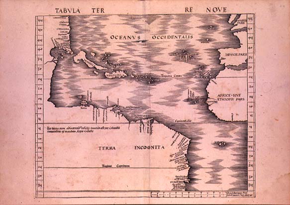 Map of America. Martin Waldseemüller. [Ptolemaeus]
Geographiae Opus Novissima Traductione...Strasbourg, 1513. The
first appearance of a map of America in a Ptolemy atlas occurred
in the 1513 Strasbourg edition, which included a series of new
maps, based on findings from recent European explorations.
Martin Waldseemüller of St. Dié began work on this
new edition of Ptolemy about 1505 and compiled the maps. In this
work, America remains as "Tierra Incognita" and Columbus is
credited with informing Isabel and Fernando of its existence.
(Geography and Map Division)
Map of America. Martin Waldseemüller. [Ptolemaeus]
Geographiae Opus Novissima Traductione...Strasbourg, 1513. The
first appearance of a map of America in a Ptolemy atlas occurred
in the 1513 Strasbourg edition, which included a series of new
maps, based on findings from recent European explorations.
Martin Waldseemüller of St. Dié began work on this
new edition of Ptolemy about 1505 and compiled the maps. In this
work, America remains as "Tierra Incognita" and Columbus is
credited with informing Isabel and Fernando of its existence.
(Geography and Map Division)
The JOHANN GEORG KOHL COLLECTION, containing early American maps and papers compiled by the German geographer Kohl, is found in the Geography and Map and the Manuscript Divisions. When Kohl (1808-1878) came to the United States in 1854, he brought his collection of facsimiles of maps on the discovery and exploration of the Americas copied through years of research in European libraries and archives. Kohl's drawings represented the most comprehensive collection of cartographic reproductions existing in America at that time. In 1856 the U.S. Congress commissioned Kohl to duplicate his drawings for a proposed catalog of early maps of America, and in 1903 they were transferred to the Library of Congress. A catalog, compiled by Justin Winsor in 1886 and reprinted with an index in 1904, describes 474 Kohl facsimiles in the Geography and Map Division.
For further study of Spain's early contacts in America, the Microform Reading Room has on microfilm the forty-two-volume Colección de documentos inéditos relativos al descubrimiento, conquista y organización de las antiguas posesiones españoles de América y Oceania (1864- 1884) and the twenty-five-volume Colección de documentos inéditos relativos al descubrimiento, conquista y organización de las antiguas posesiones españolas de ultramar (1885-1932) contain unpublished thirteenth- to eighteenth-century Spanish archival documents including papers relating to Cuba, the Philippines and Mexico and the papers of the Council of the Indies.
 Opidum S. Augustini [St.
Augustine, Florida] Augustine. Baptista Boazio. [after 1585].
Francis Drake, in 1585-1586, made raids of various communities in
the West Indies, including St. Augustine, Santiago, Santo
Domingo, and Cartagena. Baptista Boazio, an Italian artist
resident in London, made engravings of the attacks on each city,
from drawings obtained possibly from Drake himself. The Boazio
view-plan of St. Augustine is famous as the first representation
surviving of any North American city (north of Mexico, that is)
and as the first publication of any of the John White drawings of
Virginia, namely the picture of the Dorado fish, lower left on
the engraving. The Woodbury Lowery collection in which this map
is found contains a significant number of original and
photocopied maps of Spanish locations in portions of what is now
the United States. (Lowery Collection, Geography and Map
Division)
Opidum S. Augustini [St.
Augustine, Florida] Augustine. Baptista Boazio. [after 1585].
Francis Drake, in 1585-1586, made raids of various communities in
the West Indies, including St. Augustine, Santiago, Santo
Domingo, and Cartagena. Baptista Boazio, an Italian artist
resident in London, made engravings of the attacks on each city,
from drawings obtained possibly from Drake himself. The Boazio
view-plan of St. Augustine is famous as the first representation
surviving of any North American city (north of Mexico, that is)
and as the first publication of any of the John White drawings of
Virginia, namely the picture of the Dorado fish, lower left on
the engraving. The Woodbury Lowery collection in which this map
is found contains a significant number of original and
photocopied maps of Spanish locations in portions of what is now
the United States. (Lowery Collection, Geography and Map
Division)
Hans P. Kraus, in the 1970s, donated to the Library of Congress a rich collection of documents, manuscripts, maps, and books related to the activities of Francis Drake in America and Europe in the late sixteenth century. One of the earliest maps of St. Augustine, Florida, items related to Drake's raids on Spanish America and Spain in the sixteenth century, and accounts of early travel through the Straits of Magellan are included in that collection.
Conflict among European powers in Hispanic and Portuguese America is fully documented in the Library's collections. In the Manuscript Division are found the Dutch West Indian Company materials 1568-1695; the Alice Bache Gould Puerto Rican memorial collection containing eighteenth- and nineteenth-century materials on Puerto Rican politics, religion, and education; the Vernon-Wager papers containing correspondence of two British admirals pertaining to pirates and naval operations in the Caribbean during the War of Jenkins Ear; and the Irene Wright collection of transcripts of Spanish American documents from the Archivo General de Indias. In addition, one can find there the George Chalmers collection of correspondence and administrative commercial documents pertaining to the British West Indies (1670- 1825) with some materials on other areas of the Caribbean, Honduras, Brazil, and West Florida; and British Admiral George Cockburn's logbooks on 1788-1812 Spanish American revolutionary activities. The 1777 boundary dispute in South America between Spain and Portugal is the subject of a collection in the Geography and Map Division of the boundary commission's maps prepared by Francisco Requena; also found there is the 1782 map of the Peruvian royalist forces' troop movements against Tupac Amaru II.
 [Map of New Mexico, Arizona, Texas, 1766-1768]. Josef
Urrutia and Nicolás La Fora. México, 1771.
Manuscript map, 1 sheet of 4. During 1766-68, on the
instruction of Charles III of Spain, the Marqués de
Rubí inspected the presidios on the northern frontier of
New Spain, from the Gulf of California to Louisiana, in order to
recommend measures for improving the presidio system. He was
accompanied by Nicolás de La Fora and Josef Urrutia, of
the Royal Engineers, who prepared a map and report of the tour
that provided much information on the Indian peoples and
conditions along the frontier. In 1772, the king issued a
regulation based on the recommendations made as a result of the
expedition, prescribing the manner of conducting relations with
the Indians, the duties of the commandant inspector and other
military personnel, and providing for a cordon of fifteen
presidios, at intervals of about forty leagues, from Sonora to
Texas. The object was to prevent Apache raids from the north
into settled areas and to bring the Indians under military
control. The Library of Congress has a copy of the four-sheet
map of the expedition; the British Library has the diary of La
Fora and the individual presidio plans. (Vault Map Collection,
Geography and Map Division)
[Map of New Mexico, Arizona, Texas, 1766-1768]. Josef
Urrutia and Nicolás La Fora. México, 1771.
Manuscript map, 1 sheet of 4. During 1766-68, on the
instruction of Charles III of Spain, the Marqués de
Rubí inspected the presidios on the northern frontier of
New Spain, from the Gulf of California to Louisiana, in order to
recommend measures for improving the presidio system. He was
accompanied by Nicolás de La Fora and Josef Urrutia, of
the Royal Engineers, who prepared a map and report of the tour
that provided much information on the Indian peoples and
conditions along the frontier. In 1772, the king issued a
regulation based on the recommendations made as a result of the
expedition, prescribing the manner of conducting relations with
the Indians, the duties of the commandant inspector and other
military personnel, and providing for a cordon of fifteen
presidios, at intervals of about forty leagues, from Sonora to
Texas. The object was to prevent Apache raids from the north
into settled areas and to bring the Indians under military
control. The Library of Congress has a copy of the four-sheet
map of the expedition; the British Library has the diary of La
Fora and the individual presidio plans. (Vault Map Collection,
Geography and Map Division)
 [Portion]. Plano de la bahía de Pansacola [sic].
Antonio Donato Paredes. 1782. Manuscript map. Prepared shortly
after the recapture of Pensacola from the British by the Spanish
during the U.S. Revolutionary War, this detailed chart provides
accurate information on the entrance and locations of forts,
churches, and Campbelltown in Pensacola Bay. The successful 1781
Spanish offensive under Bernardo de Gálvez, on Pensacola,
effectively removed the British threat on the western flank of
the American revolutionaries. Invaluable original cartographic
and other documentary records of Spain's presence in what became
the United States are found throughout the Library of Congress's
rich collections. (Vault Map Collection, Geography and Map
Division)
[Portion]. Plano de la bahía de Pansacola [sic].
Antonio Donato Paredes. 1782. Manuscript map. Prepared shortly
after the recapture of Pensacola from the British by the Spanish
during the U.S. Revolutionary War, this detailed chart provides
accurate information on the entrance and locations of forts,
churches, and Campbelltown in Pensacola Bay. The successful 1781
Spanish offensive under Bernardo de Gálvez, on Pensacola,
effectively removed the British threat on the western flank of
the American revolutionaries. Invaluable original cartographic
and other documentary records of Spain's presence in what became
the United States are found throughout the Library of Congress's
rich collections. (Vault Map Collection, Geography and Map
Division)
In considering the long-term Luso-Hispanic presence in the United States, under Spain until 1821 and under Mexico until 1848, numerous collections are available for fruitful study. In the Manuscript Division, the JEANNETTE THURBER CONNOR COLLECTION of transcripts of sixteenth- to nineteenth-century Spanish archival documents on Spanish Florida; the WOODBURY LOWERY COLLECTION of transcripts relating to the Spanish presence in the Southeastern United States 1551-1893; the LUIS DE ONíS correspondence on the Adams-Onís Treaty (1810-1816); the VICENTE SEBASTIAN PINTADO manuscripts (correspondence, maps, reports), by the last surveyor general of Spanish West Florida (1803-1817); and the SPANISH GOVERNMENT OF EAST FLORIDA COLLECTION with some 65,000 administrative and military documents (1777-1821) are rich sources for study.
 Occupational groups. Ink and wash drawing. In
Relación de las ceremonias y ritos y población y
gobierno de los indios de la provincia de Mechuacan, compiled by
Fray Jeronimo de Alcalá. nineteenth-century manuscript
copy of original, ca. 1540. The Relación is a well-
illustrated manuscript from Mexico that chronicles the history
and customs of the Tarascan people before as well as during the
Spanish conquest in the area of Michoacán, Mexico. This
copy, one of two in the United States, is a fine nineteenth-
century manuscript facsimile of the original housed in the
library of El Escorial in Spain. Although the work was written
by a Franciscan friar, it is based largely on the accounts of
informants among the Tarascan nobility and priests and thus is
significant as a source from the Conquest period that essentially
expresses an indigenous point of view. In the illustration, the
artist depicted various occupational groups existing before the
arrival of the Spanish. Groups of seated figures are placed with
an object or symbol such as a net, a loom, a bow and an arrow, a
writing instrument, feathers, etc., that identifies the
occupation of a specific group. Figures in the upper portion of
the illustration sit alone and are identified as being the
Cazonci (or ruler) and his governor. (Peter Force Collection,
Manuscript Division)
Occupational groups. Ink and wash drawing. In
Relación de las ceremonias y ritos y población y
gobierno de los indios de la provincia de Mechuacan, compiled by
Fray Jeronimo de Alcalá. nineteenth-century manuscript
copy of original, ca. 1540. The Relación is a well-
illustrated manuscript from Mexico that chronicles the history
and customs of the Tarascan people before as well as during the
Spanish conquest in the area of Michoacán, Mexico. This
copy, one of two in the United States, is a fine nineteenth-
century manuscript facsimile of the original housed in the
library of El Escorial in Spain. Although the work was written
by a Franciscan friar, it is based largely on the accounts of
informants among the Tarascan nobility and priests and thus is
significant as a source from the Conquest period that essentially
expresses an indigenous point of view. In the illustration, the
artist depicted various occupational groups existing before the
arrival of the Spanish. Groups of seated figures are placed with
an object or symbol such as a net, a loom, a bow and an arrow, a
writing instrument, feathers, etc., that identifies the
occupation of a specific group. Figures in the upper portion of
the illustration sit alone and are identified as being the
Cazonci (or ruler) and his governor. (Peter Force Collection,
Manuscript Division)
The WOODBURY LOWERY COLLECTION in the Geography and Map and Manuscript Divisions contains 300 original and facsimile maps and eighteen volumes of notes and transcripts from Washington patent lawyer and historian Woodbury Lowery (1853-1906). The collection relates to the study of the former Spanish possessions within the United States. The eighteen volumes of Lowery's notes and transcripts in the Manuscript Division pertain to the early history of Florida, the subject of Lowery's The Spanish Settlements Within the Present Limits of the United States (1905), and to New Mexico, California, Texas, and Louisiana.
The WEST FLORIDA PAPERS, in the Manuscript Division, concern the government of Spain there, especially during the crucial late eighteenth- and early nineteenth-century periods. These papers contain information on the British in West Florida (1762-1783) and the conspirators in the 1810 West Florida Revolution, which separated the Louisiana portion of Spanish West Florida from Spain. Of utmost relevance to the West Florida papers are the correspondence and maps found in the Pintado documents previously noted. Pintado served as a surveyor in Louisiana from the late eighteenth century until 1805 and as surveyor general for all of Spanish West Florida from Pensacola during 1805 to 18l7. Complementing all of these records are the PAPERS OF THE PANTON, LESLIE AND COMPANY, a twenty-six-reel microfilm collection in the Microform Reading Room, containing the records of a British firm in Spanish Pensacola which conducted trade throughout the region during the late eighteenth and the early nineteenth centuries.
The Microform Reading Room also has the DOCUMENTARY RELATIONS OF THE SOUTHWEST COLLECTION (on eighty-one microfiches) which includes indexes to primary documents on the southwestern part of what is now the United States from 1520 to 1820, with extensive lists of names of persons mentioned in the documents.
 Oztoticpac Lands Map. Amate paper, ca. 1540.
Mexico.
Picture writing on manuscripts of amate paper or on animal skin
is of unknown antiquity in Mesoamerica, although it substantially
predates the arrival of Europeans to America. Following the
Spanish conquest of Mexico in the first quarter of the sixteenth
century, painted manuscripts in various native artistic
traditions continued to be produced. In civil and economic
matters Indian peoples and Spaniards alike found that maps,
tribute registers, and cadastral and census documents derived
from native traditions met a common need. The Oztoticpac
(Mexico) Lands Map is a central Mexican pictorial document with
Spanish and Nahuatl writing showing litigation surrounding the
Oztoticpac estate within the city of Texcoco. The document
involves the land and property ownership of the ruler of Texcoco,
Don Carlos Ometochtli Chichimecatecotl, who was executed during
the early days of the Spanish conquest. Most of the drawings on
the map are plans of fields with indigenous measurements and
place glyphs. Near the upper left is the plan of several houses
within a precinct. On the upper right is a map showing about
seventy-five plots of land. Nahuatl and Spanish descriptions
appear. In the lower left are depictions of tree grafts, showing
European fruit tree branches grafted to indigenous tree trunks.
This unique cartographic object is the earliest recorded lawsuit
or conflict in horticultural literature anywhere in the world.
(Vault Map Collection, Geography and Map Division)
Oztoticpac Lands Map. Amate paper, ca. 1540.
Mexico.
Picture writing on manuscripts of amate paper or on animal skin
is of unknown antiquity in Mesoamerica, although it substantially
predates the arrival of Europeans to America. Following the
Spanish conquest of Mexico in the first quarter of the sixteenth
century, painted manuscripts in various native artistic
traditions continued to be produced. In civil and economic
matters Indian peoples and Spaniards alike found that maps,
tribute registers, and cadastral and census documents derived
from native traditions met a common need. The Oztoticpac
(Mexico) Lands Map is a central Mexican pictorial document with
Spanish and Nahuatl writing showing litigation surrounding the
Oztoticpac estate within the city of Texcoco. The document
involves the land and property ownership of the ruler of Texcoco,
Don Carlos Ometochtli Chichimecatecotl, who was executed during
the early days of the Spanish conquest. Most of the drawings on
the map are plans of fields with indigenous measurements and
place glyphs. Near the upper left is the plan of several houses
within a precinct. On the upper right is a map showing about
seventy-five plots of land. Nahuatl and Spanish descriptions
appear. In the lower left are depictions of tree grafts, showing
European fruit tree branches grafted to indigenous tree trunks.
This unique cartographic object is the earliest recorded lawsuit
or conflict in horticultural literature anywhere in the world.
(Vault Map Collection, Geography and Map Division)
The long history of indigenous societies in the Americas is richly reflected in the general and special collections of the Library of Congress. Reproductions of pre-Columbian and European-contact period Indian documents, including codices, are found in the Rare Book and Special Collections Division, in the general books collection, and in photographic copies in the Prints and Photographs Division's JOHN B. GLASS COLLECTION and the ARCHIVE OF HISPANIC CULTURE COLLECTION.
Numerous other records of Indian culture are found. A collection of original manuscripts and photocopies of Indian- language documents from Mesoamerica, from the sixteenth to the early twentieth century, is found in the WILLIAM GATES COLLECTION of historical and linguistic manuscripts in the Manuscript Division. A companion record in that same division, the 5,700- item RUDOLPH R. SCHULLER COLLECTION, acquired from Schuller in 1914, contains manuscript copies of archaeological, ethnographic, linguistic, and cartographic manuscripts of Central and South American areas. Over two hundred boxes and twenty-five volumes of dictionaries, vocabularies, translations of Mexica dramas, and other materials in the Indian languages of Mexico and Central America are located in miscellaneous collections in the Manuscript Division. A manuscript copy of Father José de Anchieta's Arte de grammatica da lingoa mais usada na costa do brazil (1595) is also found in the Manuscript Division.
The G.R.G. CONWAY COLLECTION contains copied documents on sixteenth-century Britons in Mexico from the Inquisición section of the Archivo General y Público in Mexico City and the Archivo General de Indias in Sevilla. That forty-five- volume set in the Manuscript Division is supported by papers on the Inquisition in New Mexico from the papers in the Archivo General y Público in Mexico City donated by France Scholes in 1930 and on the Inquisition in Texas from the same archive provided by Charles W. Hackett. In addition, some 3,500 typewritten pages of documents on the late eighteenth- and early nineteenth-century history of Spanish Texas was donated by Professor Hackett.
The HISTORIC AMERICAN BUILDINGS SURVEY, a collection of measured drawings, photographs, and data sheets documenting works of American architecture, in the Prints and Photographs Division, is the largest and most important architectural collection in that division. The project documented structures in all fifty states, Puerto Rico, the Virgin Islands, and the District of Columbia. Numerous buildings of the Hispanic period from the states of Alabama, Mississippi, Arizona, Louisiana, Florida, California, Colorado, New Mexico, Texas, and Puerto Rico are found in the records. Another source for reproductions of colonial period and pre-Columbian structures in Latin America is the ARCHIVE OF HISPANIC CULTURE COLLECTION, also in the Prints and Photographs Division.
 Details of Pulpit. Mission San Xavier del Bac, Tucson
Vicinity, Pima County, Arizona. 1940. In 1700, the Jesuit Father
Eusebio Francisco Kino founded the mission of San Xavier del Bac
on the Santa Cruz river, near present-day Tucson. Other efforts
during that time opened missions in California and elsewhere in
Arizona. These sites were linked to missions in Sonora and Baja
California. The Library's collection of building surveys
provides essential information for the study of Spanish
historical structures in those parts of the United States which
were once under Spanish dominion. (Historic American Buildings
Survey, Prints and Photographs Division)
Details of Pulpit. Mission San Xavier del Bac, Tucson
Vicinity, Pima County, Arizona. 1940. In 1700, the Jesuit Father
Eusebio Francisco Kino founded the mission of San Xavier del Bac
on the Santa Cruz river, near present-day Tucson. Other efforts
during that time opened missions in California and elsewhere in
Arizona. These sites were linked to missions in Sonora and Baja
California. The Library's collection of building surveys
provides essential information for the study of Spanish
historical structures in those parts of the United States which
were once under Spanish dominion. (Historic American Buildings
Survey, Prints and Photographs Division)
The Microform Reading Room's Archivo Franciscano, on nineteen reels of microfilm (from the holdings of the Mexican Instituto Nacional de Antropología e Historia) contains sixteenth- to eighteenth-century documents from both Franciscan and non-Franciscan sources on that order's activities in Mexico, California, and the southwestern part of the United States. These documents address ecclesiastical, military, local history, missionary activity, Jesuit expulsion, exploration, discovery, conquest of new territories, and Indian relation topics.
Slavery tracts and pamphlets from the WEST INDIA COMMITTEE COLLECTION, at the Institute of Commonwealth Studies, are found on twenty-eight reels of microfilm in the Microform Reading Room. The collection consists mainly of early nineteenth-century publications from England and the West Indies, including works by Prime Minister George Canning, by the parliaments of Great Britain, Jamaica, the Bahamas, St. Vincent, and Barbados, by various Bible societies, and by noteworthy proponents and opponents of the continuation of slavery in the West Indies.
 Map of Mexico City and the Gulf of Mexico. In Hernando
Cortés. Praeclara Ferdinandi Cortesii de Nova maris
Hyspania narratio. [Norimbergae] [1524]. This map, actually two
separate maps on one sheet, one of Tenochtitlán (Mexico
City) prepared by the Mexicas and presented to Cortés as a
gift in the 1519-1521 period, and a map of the Gulf Coast region
of Mexico and the southeastern part of the present-day United
States, was prepared either by the Mexica peoples or by a
contemporary Spanish explorer. These maps appeared with the
second letter of Hernando Cortés to Charles V, King of
Spain. There is much in both of these maps to suggest that the
drawings supplied to the Nuremberg engraver who prepared the
printer's woodblock were based on Mexica (Aztec) originals.
Cortés, anxious to inform and to impress Charles V, sent
his lieutenant Juan de Ribera in 1522 to deliver samples of Aztec
objets d'art and treasure to the royal court. Ribera also
carried maps of Mexica origin which were examined by Peter
Martyr. Martyr described one Aztec map that was thirty feet long
painted on white cotton cloth, and a smaller native painting
representing the town of Temistitan (Tenochtitlán) with
its temples, bridges, and lakes. The volume in which the maps
appear is part of the spectacular collection of illuminated
imprints presented to the Library by Lessing J. Rosenwald.
(Rosenwald Collection, Rare Book and Special Collections
Division)
Map of Mexico City and the Gulf of Mexico. In Hernando
Cortés. Praeclara Ferdinandi Cortesii de Nova maris
Hyspania narratio. [Norimbergae] [1524]. This map, actually two
separate maps on one sheet, one of Tenochtitlán (Mexico
City) prepared by the Mexicas and presented to Cortés as a
gift in the 1519-1521 period, and a map of the Gulf Coast region
of Mexico and the southeastern part of the present-day United
States, was prepared either by the Mexica peoples or by a
contemporary Spanish explorer. These maps appeared with the
second letter of Hernando Cortés to Charles V, King of
Spain. There is much in both of these maps to suggest that the
drawings supplied to the Nuremberg engraver who prepared the
printer's woodblock were based on Mexica (Aztec) originals.
Cortés, anxious to inform and to impress Charles V, sent
his lieutenant Juan de Ribera in 1522 to deliver samples of Aztec
objets d'art and treasure to the royal court. Ribera also
carried maps of Mexica origin which were examined by Peter
Martyr. Martyr described one Aztec map that was thirty feet long
painted on white cotton cloth, and a smaller native painting
representing the town of Temistitan (Tenochtitlán) with
its temples, bridges, and lakes. The volume in which the maps
appear is part of the spectacular collection of illuminated
imprints presented to the Library by Lessing J. Rosenwald.
(Rosenwald Collection, Rare Book and Special Collections
Division)
![]()
![]()
![]()
 Library of Congress
Comments: Ask a Librarian ( July 15, 2010 )
Legal | External Link Disclaimer