Title: Map of Mississippi, Louisiana and Arkansas
Description
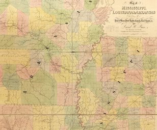
- David H. Burr (1803–75) was a surveyor and cartographer, who served as topographer to the United States Post Office Department in 1832–38 and as geographer to the House of Representatives in 1838–47. Under the direction of the postmaster general, Burr compiled information from postmasters throughout the country about transportation routes—post roads, railroads, and canals—and the location of post offices to produce a large set of state and regional maps. Published in 1839 by the prominent London mapmaking firm of John Arrowsmith, Burr’s The American Atlas offers a detailed picture of settlement and transportation patterns in the United States in the decades before the Civil War. Shown here is Burr’s map of Mississippi, Louisiana, and Arkansas, one of 13 maps in the atlas. On April 30, 1812, Louisiana became the 18th U.S. state (and the first carved out of the Louisiana Territory purchased from France in 1803). Mississippi was admitted to the Union as the 20th state on December 10, 1817. Arkansas was organized as a territory in 1819 and became the 25th state on June 15, 1836. The three states were tied together by their economic lifeline, the Mississippi River. With the significant exception of the cosmopolitan port city of New Orleans, all three states were overwhelmingly rural and had few large cities or towns.
Cartographer
Publication Information
Language
Place
Time
Topic
Additional Subjects
Type of Item
Physical Description
- 1 map from loose-leaf atlas : hand colored, mounted on cloth ; 130 x 130 centimeters or smaller, folded in case 50 x 33 x 7 centimeters
Institution
