Map
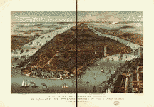
Bird's eye view Coney Island.

| Format |
Map |
|---|---|
| Contributors |
Mark, John G. |
| Dates |
1906 |
| Location |
Coney Island New York United States |
| Language |
English |
| Subjects |
Coney Island (New York) New York (State) United States View |
- Title
- Bird's eye view Coney Island.
- Description
-
Available also through the Library of Congress Web site as a raster image.
-
1 view : col. ; 26 x 46 cm.
- Creator
- Mark, John G.
- Created Published
-
[S.l.], 1906.
- Subject Headings
-
-
View.
-
-
United States--New York (State)--Coney Island (New York)
- Notes
-
-
Available also through the Library of Congress Web site as a raster image.
- Medium
-
1 view : col. ; 26 x 46 cm.
- Call Number
-
G3804.N4:2C67A3 1906 .M3 TIL
- Repository
-
Library of Congress Geography and Map Division Washington, D.C. 20540-4650 dcu
- Digital Id
-
g3804n pm005521 http://hdl.loc.gov/loc.gmd/g3804n.pm005521
- Library of Congress Catalog Number
- 98687100
Rights & Access
The maps in the Map Collections materials were either published prior to 1922, produced by the United States government, or both (see catalogue records that accompany each map for information regarding date of publication and source). The Library of Congress is providing access to these materials for educational and research purposes and is not aware of any U.S. copyright protection (see Title 17 of the United States Code) or any other restrictions in the Map Collection materials.
Note that the written permission of the copyright owners and/or other rights holders (such as publicity and/or privacy rights) is required for distribution, reproduction, or other use of protected items beyond that allowed by fair use or other statutory exemptions. Responsibility for making an independent legal assessment of an item and securing any necessary permissions ultimately rests with persons desiring to use the item.
More about Copyright and other Restrictions
For guidance about compiling full citations consult Citing Primary Sources.
Part of...
-
Panoramic Maps
[1461]
-
Cities And Towns
[1965]
-
Geography And Maps Division
[60803]
-
American Memory
[1121009]
More maps like this
-
 Map of Coney Island, town of Gravesend, Kings County, state of New York /
Contributor:
Kowalski, William
Site:
American Memory-cultural, Main Catalog
Original Format:
Map
Date:
1879
View catalog record
Map of Coney Island, town of Gravesend, Kings County, state of New York /
Contributor:
Kowalski, William
Site:
American Memory-cultural, Main Catalog
Original Format:
Map
Date:
1879
View catalog record
-
 The city of New York.
Site:
American Memory-cultural, Main Catalog
Original Format:
Map
Date:
1883
View catalog record
The city of New York.
Site:
American Memory-cultural, Main Catalog
Original Format:
Map
Date:
1883
View catalog record
-
 New York.
Site:
American Memory-cultural, Main Catalog
Original Format:
Map
Date:
1879
View catalog record
New York.
Site:
American Memory-cultural, Main Catalog
Original Format:
Map
Date:
1879
View catalog record
-
 Proposed site for World's Fair in 1883 : between 110th and 125th Streets, Morning Side and River Side Parks, N.Y. Area 300 acres.
Contributor:
Stranders, Walter
Site:
American Memory-cultural, Main Catalog
Original Format:
Map
Date:
1879
View catalog record
Proposed site for World's Fair in 1883 : between 110th and 125th Streets, Morning Side and River Side Parks, N.Y. Area 300 acres.
Contributor:
Stranders, Walter
Site:
American Memory-cultural, Main Catalog
Original Format:
Map
Date:
1879
View catalog record
-
 View of St. Augustine, East Florida.
Contributor:
Horton, John S.
Site:
American Memory-cultural, Main Catalog
Original Format:
Map
Date:
1855
View catalog record
View of St. Augustine, East Florida.
Contributor:
Horton, John S.
Site:
American Memory-cultural, Main Catalog
Original Format:
Map
Date:
1855
View catalog record
-
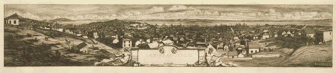 San Francisco.
Contributor:
Méryon, Charles, Méryon, Charles
Site:
American Memory-cultural, Main Catalog
Original Format:
Map
Date:
1856
View catalog record
San Francisco.
Contributor:
Méryon, Charles, Méryon, Charles
Site:
American Memory-cultural, Main Catalog
Original Format:
Map
Date:
1856
View catalog record
-
 A view of Savannah as it stood the 29th of March 1734.
Contributor:
Gordon, Peter
Site:
American Memory-cultural, Main Catalog
Original Format:
Map
Date:
1876
View catalog record
A view of Savannah as it stood the 29th of March 1734.
Contributor:
Gordon, Peter
Site:
American Memory-cultural, Main Catalog
Original Format:
Map
Date:
1876
View catalog record
-
 World's Fair, St Louis, 1904.
Site:
American Memory-cultural, Main Catalog
Original Format:
Map
Date:
1904
View catalog record
World's Fair, St Louis, 1904.
Site:
American Memory-cultural, Main Catalog
Original Format:
Map
Date:
1904
View catalog record
-
 Panorama of the World's Fair, St Louis, 1904.
Contributor:
Melville, George W.
Site:
American Memory-cultural, Main Catalog
Original Format:
Map
Date:
1904
View catalog record
Panorama of the World's Fair, St Louis, 1904.
Contributor:
Melville, George W.
Site:
American Memory-cultural, Main Catalog
Original Format:
Map
Date:
1904
View catalog record
-
 Bird's eye view of the World's Columbian Exposition, Chicago, 1893.
Contributor:
Rand McNally and Company
Site:
American Memory-cultural, Main Catalog
Original Format:
Map
Date:
1893
View catalog record
Bird's eye view of the World's Columbian Exposition, Chicago, 1893.
Contributor:
Rand McNally and Company
Site:
American Memory-cultural, Main Catalog
Original Format:
Map
Date:
1893
View catalog record
-

 State of New-York for Spafford's gazetteer /
Contributor:
Spafford, Horatio Gates
Site:
Main Catalog
Original Format:
Map
Date:
1813
State of New-York for Spafford's gazetteer /
Contributor:
Spafford, Horatio Gates
Site:
Main Catalog
Original Format:
Map
Date:
1813
-
 New York /
Contributor:
Tanner, Henry Schenck
Site:
American Memory-cultural, Main Catalog
Original Format:
Map
Date:
1823
View catalog record
New York /
Contributor:
Tanner, Henry Schenck
Site:
American Memory-cultural, Main Catalog
Original Format:
Map
Date:
1823
View catalog record
-
 Map of the State of New York.
Contributor:
De Witt, Simeon
Site:
American Memory-cultural, Main Catalog
Original Format:
Map
Date:
1802
View catalog record
Map of the State of New York.
Contributor:
De Witt, Simeon
Site:
American Memory-cultural, Main Catalog
Original Format:
Map
Date:
1802
View catalog record
-
 N.W. parts of New York, no. 156.
Site:
American Memory-cultural, Main Catalog
Original Format:
Map
Date:
1750
View catalog record
N.W. parts of New York, no. 156.
Site:
American Memory-cultural, Main Catalog
Original Format:
Map
Date:
1750
View catalog record
-
 A map of the State of New York.
Contributor:
De Witt, Simeon
Site:
American Memory-cultural, Main Catalog
Original Format:
Map
Date:
1804
View catalog record
A map of the State of New York.
Contributor:
De Witt, Simeon
Site:
American Memory-cultural, Main Catalog
Original Format:
Map
Date:
1804
View catalog record
-
 Map of New York exhibiting the post offices, post roads, canals, rail roads &c. By David H. Burr; (Late topographer to the Post Office.) Geographer ...
Contributor:
Burr, David H.
Site:
American Memory-cultural, Main Catalog
Original Format:
Map
Date:
1839
View catalog record
Map of New York exhibiting the post offices, post roads, canals, rail roads &c. By David H. Burr; (Late topographer to the Post Office.) Geographer ...
Contributor:
Burr, David H.
Site:
American Memory-cultural, Main Catalog
Original Format:
Map
Date:
1839
View catalog record
You might also like
-
 Coney Island, 1910
Contributor:
Geo. P. Hall & Son
Site:
Prints & Photographs, Main Catalog
Original Format:
Photo, Print, Drawing
Date:
1910
View catalog record
Coney Island, 1910
Contributor:
Geo. P. Hall & Son
Site:
Prints & Photographs, Main Catalog
Original Format:
Photo, Print, Drawing
Date:
1910
View catalog record
-
 Food vendors, Coney Island, New York
Contributor:
Highsmith, Carol M.
Site:
Prints & Photographs, Main Catalog
Original Format:
Photo, Print, Drawing
Date:
1980
View catalog record
Food vendors, Coney Island, New York
Contributor:
Highsmith, Carol M.
Site:
Prints & Photographs, Main Catalog
Original Format:
Photo, Print, Drawing
Date:
1980
View catalog record
-
 [Destruction of dreamland, Coney Island]
Contributor:
Stacy, Charles E.
Site:
Prints & Photographs, Main Catalog
Original Format:
Photo, Print, Drawing
Date:
1911
View catalog record
[Destruction of dreamland, Coney Island]
Contributor:
Stacy, Charles E.
Site:
Prints & Photographs, Main Catalog
Original Format:
Photo, Print, Drawing
Date:
1911
View catalog record
-
 Manhattan Beach
Contributor:
Falk, B. J. (Benjamin J.)
Site:
Prints & Photographs, Main Catalog
Original Format:
Photo, Print, Drawing
Date:
1902
View catalog record
Manhattan Beach
Contributor:
Falk, B. J. (Benjamin J.)
Site:
Prints & Photographs, Main Catalog
Original Format:
Photo, Print, Drawing
Date:
1902
View catalog record
-
 On the beach at Coney Island
Contributor:
Detroit Photographic Co
Site:
Prints & Photographs, Main Catalog
Original Format:
Photo, Print, Drawing
Date:
1902
View catalog record
On the beach at Coney Island
Contributor:
Detroit Photographic Co
Site:
Prints & Photographs, Main Catalog
Original Format:
Photo, Print, Drawing
Date:
1902
View catalog record
-
 Coney Island, Luna Park [i.e., Dreamland]
Contributor:
Stacy, Charles E.
Site:
Prints & Photographs, Main Catalog
Original Format:
Photo, Print, Drawing
Date:
1907
View catalog record
Coney Island, Luna Park [i.e., Dreamland]
Contributor:
Stacy, Charles E.
Site:
Prints & Photographs, Main Catalog
Original Format:
Photo, Print, Drawing
Date:
1907
View catalog record