Map
The upper Mississippi and Missouri /

| Format |
Map |
|---|---|
| Contributors |
Kohl, J. G. |
| Dates |
1850 |
| Location |
Canada Mississippi River Region Missouri River Region Northwestern States United States Western |
| Language |
French |
| Subjects |
Canada, Western Mississippi River Region Missouri River Region Northwestern States United States |
- Title
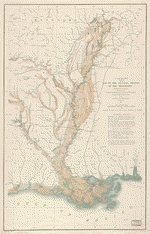
- The upper Mississippi and Missouri /
- Description
-
Covers the northwestern United States and western Canada.
-
Relief shown pictorially.
-
French. Title and notes in English.
-
Traced by J.G. Kohl from the original map: Idee topographique des huts de Mississipi et du Missouri ... / dessinèe par Mr. Soulard ancien, S. Lant de port de la marine. rle. de France et Captne. des milices de S.M.C. aux yllinois ......
-
"This is a copy of a map preserved in the depot de la Marine at Paris."
-
Pen-and-ink and watercolor.
-
Available also through the Library of Congress Web site as a raster image.
-
Includes notes.
-
Map and two sections of notes mounted on paper mounted on cloth.
-
1 map : ms., col. ; 39 x 48 cm.
-
Traced by J.G. Kohl from the original map: Idee topographique des huts de Mississipi et du Missouri ... / dessinèe par Mr. Soulard ancien, S. Lant de port de la marine. rle. de France et Captne. des milices de S.M.C. aux yllinois ......
- Creator
- Kohl, J. G.
- Created Published
-
[ca. 1850]
- Subject Headings
-
-
Northwestern States
-
-
Canada, Western
-
-
Mississippi River Region
-
-
Missouri River Region
-
-
United States--Northwestern States.
-
-
Canada, Western.
-
-
United States--Mississippi River Region.
-
-
United States--Missouri River Region.
- Notes
-
-
Covers the northwestern United States and western Canada.
-
-
Relief shown pictorially.
-
-
French. Title and notes in English.
-
-
Traced by J.G. Kohl from the original map: Idee topographique des huts de Mississipi et du Missouri ... / dessinèe par Mr. Soulard ancien, S. Lant de port de la marine. rle. de France et Captne. des milices de S.M.C. aux yllinois ......
-
-
"This is a copy of a map preserved in the depot de la Marine at Paris."
-
-
Pen-and-ink and watercolor.
-
-
Available also through the Library of Congress Web site as a raster image.
-
-
Includes notes.
-
-
Map and two sections of notes mounted on paper mounted on cloth.
- Medium
-
1 map : ms., col. ; 39 x 48 cm.
- Call Number
-
G4125 1795 .K6
- Repository
-
Library of Congress Geography and Map Division Washington, D.C. 20540-4650 USA dcu
- Digital Id
-
g4125 ct000683 http://hdl.loc.gov/loc.gmd/g4125.ct000683
- Library of Congress Catalog Number
- 2002622302
Rights & Access
The maps in the Map Collections materials were either published prior to 1922, produced by the United States government, or both (see catalogue records that accompany each map for information regarding date of publication and source). The Library of Congress is providing access to these materials for educational and research purposes and is not aware of any U.S. copyright protection (see Title 17 of the United States Code) or any other restrictions in the Map Collection materials.
Note that the written permission of the copyright owners and/or other rights holders (such as publicity and/or privacy rights) is required for distribution, reproduction, or other use of protected items beyond that allowed by fair use or other statutory exemptions. Responsibility for making an independent legal assessment of an item and securing any necessary permissions ultimately rests with persons desiring to use the item.
More about Copyright and other Restrictions
For guidance about compiling full citations consult Citing Primary Sources.
Part of...
-
Louisiana: European Explorations And The Louisiana Purchase
[77]
-
Discovery And Exploration
[150]
-
Geography And Maps Division
[60803]
-
American Memory
[1121009]
More maps like this
-
 Hudson's Bay's country /
Contributor:
Kohl, J. G.
Site:
American Memory-cultural, Main Catalog
Original Format:
Map
Date:
1850
View catalog record
Hudson's Bay's country /
Contributor:
Kohl, J. G.
Site:
American Memory-cultural, Main Catalog
Original Format:
Map
Date:
1850
View catalog record
-
 Map of the discovery of the ...
Contributor:
Kohl, J. G.
Site:
American Memory-cultural, Main Catalog
Original Format:
Map
Date:
1856
View catalog record
Map of the discovery of the ...
Contributor:
Kohl, J. G.
Site:
American Memory-cultural, Main Catalog
Original Format:
Map
Date:
1856
View catalog record
-
 Map of the alluvial region of the Mississippi /
Contributor:
Mahon, Charles
Site:
American Memory-cultural, Main Catalog
Original Format:
Map
Date:
1861
View catalog record
Map of the alluvial region of the Mississippi /
Contributor:
Mahon, Charles
Site:
American Memory-cultural, Main Catalog
Original Format:
Map
Date:
1861
View catalog record
-
 The Great overflow : Inundated districts of the Mississippi Valey [sic] /
Contributor:
Zenneck, A.
Site:
American Memory-cultural, Main Catalog
Original Format:
Map
Date:
1874
View catalog record
The Great overflow : Inundated districts of the Mississippi Valey [sic] /
Contributor:
Zenneck, A.
Site:
American Memory-cultural, Main Catalog
Original Format:
Map
Date:
1874
View catalog record
-
 The Mississippi /
Contributor:
Franquelin, Jean Baptiste Louis
Site:
American Memory-cultural, Main Catalog
Original Format:
Map
Date:
1682
View catalog record
The Mississippi /
Contributor:
Franquelin, Jean Baptiste Louis
Site:
American Memory-cultural, Main Catalog
Original Format:
Map
Date:
1682
View catalog record
-
 Carte de la rivière de Mississipi : sur les mémoires de Mr. Le Sueur qui en a pris avec la boussole tous les tours et ...
Contributor:
L'Isle, Guillaume de
Site:
American Memory-cultural, Main Catalog
Original Format:
Map
Date:
1702
View catalog record
Carte de la rivière de Mississipi : sur les mémoires de Mr. Le Sueur qui en a pris avec la boussole tous les tours et ...
Contributor:
L'Isle, Guillaume de
Site:
American Memory-cultural, Main Catalog
Original Format:
Map
Date:
1702
View catalog record
-
 An Indian map of the Upper-Missouri, 1801.
Contributor:
Kohl, J. G.
Site:
American Memory-cultural, Main Catalog
Original Format:
Map
Date:
1850
View catalog record
An Indian map of the Upper-Missouri, 1801.
Contributor:
Kohl, J. G.
Site:
American Memory-cultural, Main Catalog
Original Format:
Map
Date:
1850
View catalog record
-
 A Plan of the coast of part of west Florida & Louisiana : including the River Yazous /
Contributor:
Gauld, George
Site:
American Memory-cultural, Main Catalog
Original Format:
Map
Date:
1778
View catalog record
A Plan of the coast of part of west Florida & Louisiana : including the River Yazous /
Contributor:
Gauld, George
Site:
American Memory-cultural, Main Catalog
Original Format:
Map
Date:
1778
View catalog record
-
 The Alaska Line.
Contributor:
Alaska Steamship Co
Site:
American Memory-cultural, Main Catalog
Original Format:
Map
Date:
1934
View catalog record
The Alaska Line.
Contributor:
Alaska Steamship Co
Site:
American Memory-cultural, Main Catalog
Original Format:
Map
Date:
1934
View catalog record
-
 Map of the country tributary to the Northern Pacific Railroad, compiled from English, Canadian, and American official sources and original surveys by Edward H. Knight, ...
Contributor:
Knight, E. H.
Site:
American Memory-cultural, Main Catalog
Original Format:
Map
Date:
1871
View catalog record
Map of the country tributary to the Northern Pacific Railroad, compiled from English, Canadian, and American official sources and original surveys by Edward H. Knight, ...
Contributor:
Knight, E. H.
Site:
American Memory-cultural, Main Catalog
Original Format:
Map
Date:
1871
View catalog record
-
 National parks of the Midwest.
Contributor:
United States. National Park Service
Site:
American Memory-cultural, Main Catalog
Original Format:
Map
Date:
1968
View catalog record
National parks of the Midwest.
Contributor:
United States. National Park Service
Site:
American Memory-cultural, Main Catalog
Original Format:
Map
Date:
1968
View catalog record
-
 A map of Lewis and Clark's track across the western portion of North America, from the Mississippi to the Pacific Ocean : by order of ...
Contributor:
Lewis, Samuel
Site:
American Memory-cultural, Main Catalog
Original Format:
Map
Date:
1814
View catalog record
A map of Lewis and Clark's track across the western portion of North America, from the Mississippi to the Pacific Ocean : by order of ...
Contributor:
Lewis, Samuel
Site:
American Memory-cultural, Main Catalog
Original Format:
Map
Date:
1814
View catalog record
-
 [Lewis and Clark map, with annotations in brown ink by Meriwether Lewis, tracing showing the Mississippi, the Missouri for a short distance above Kansas, Lakes ...
Contributor:
King, N.
Site:
American Memory-cultural, Main Catalog
Original Format:
Map
Date:
1803
View catalog record
[Lewis and Clark map, with annotations in brown ink by Meriwether Lewis, tracing showing the Mississippi, the Missouri for a short distance above Kansas, Lakes ...
Contributor:
King, N.
Site:
American Memory-cultural, Main Catalog
Original Format:
Map
Date:
1803
View catalog record
-
 A map of the discoveries of Capt. Lewis & Clark from the Rockey Mountain and the River Lewis to the Cap of Disappointement or the ...
Contributor:
Frazer, Robert
Site:
American Memory-cultural, Main Catalog
Original Format:
Map
Date:
1807
View catalog record
A map of the discoveries of Capt. Lewis & Clark from the Rockey Mountain and the River Lewis to the Cap of Disappointement or the ...
Contributor:
Frazer, Robert
Site:
American Memory-cultural, Main Catalog
Original Format:
Map
Date:
1807
View catalog record
-
 A map of Lewis and Clark's track, across the western portion of North America from the Mississippi to the Pacific Ocean : by order of ...
Contributor:
Lewis, Samuel
Site:
American Memory-cultural, Main Catalog
Original Format:
Map
Date:
1814
View catalog record
A map of Lewis and Clark's track, across the western portion of North America from the Mississippi to the Pacific Ocean : by order of ...
Contributor:
Lewis, Samuel
Site:
American Memory-cultural, Main Catalog
Original Format:
Map
Date:
1814
View catalog record
-
 Touring map of the Custer Battlefield Hiway: the scenic route to the west.
Contributor:
Mulford, John C.
Site:
American Memory-cultural, Main Catalog
Original Format:
Map
Date:
1925
View catalog record
Touring map of the Custer Battlefield Hiway: the scenic route to the west.
Contributor:
Mulford, John C.
Site:
American Memory-cultural, Main Catalog
Original Format:
Map
Date:
1925
View catalog record
You might also like
-

 Potential effects of Missouri River spring rises on crop insurance policies : hearing before the Subcommittee on General Farm Commodities and Risk Management of the ...
Contributor:
United States. Congress. House. Committee on Agriculture. Subcommittee on General Farm Commodities and Risk Management
Site:
Main Catalog
Original Format:
Book
Date:
2006-02-28
Potential effects of Missouri River spring rises on crop insurance policies : hearing before the Subcommittee on General Farm Commodities and Risk Management of the ...
Contributor:
United States. Congress. House. Committee on Agriculture. Subcommittee on General Farm Commodities and Risk Management
Site:
Main Catalog
Original Format:
Book
Date:
2006-02-28
-
 People engaged in outdoor activities in the Northwestern United States.
Site:
Main Catalog
Original Format:
Photo, Print, Drawing
Date:
1905
People engaged in outdoor activities in the Northwestern United States.
Site:
Main Catalog
Original Format:
Photo, Print, Drawing
Date:
1905
-
The Northwest illustrated for tourists of 1874.
Contributor:
Chicago and Northwestern railway [company]
Site:
Main Catalog
Original Format:
Book
Date:
1874
-
Valley, plain and peak ... Scenes on the line of the Great northern railway.
Contributor:
Great Northern Railway Company (U.S.)
Site:
Main Catalog
Original Format:
Book
Date:
1894
-
Autobiography of Roosevelt's adversary,
Contributor:
Fullerton, James
Site:
Main Catalog
Original Format:
Book
Date:
1912
-
Procurement contracting in the affected counties of the Northwest Forest Plan : 12 years of change /
Contributor:
Moseley, Cassandra
Site:
Main Catalog
Original Format:
Book
Date:
2006