Map
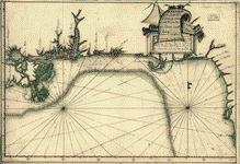
A Plan of West Florida, the Isle of Orleans, and some parts of the Spanish dominions to the westward of the Mississipi.

| Format |
Map |
|---|---|
| Dates |
1763 |
| Location |
Gulf Coast Mississippi United States |
| Language |
English |
| Subjects |
Gulf Coast Gulf Coast (U.S.) Mississippi United States |
- Title
- A Plan of West Florida, the Isle of Orleans, and some parts of the Spanish dominions to the westward of the Mississipi.
- Description
-
Scale 1:760,320; 12 miles to an in.
-
Manuscript, pen-and-ink and watercolor.
-
Shows the present state of Mississippi, southeastern Louisiana, and Mobile Bay.
-
Includes note on navigation and "This line being proposed to be the eastern boundary of the New Collony is supposed to run parrallel to the R. Mississipi and to continue in this direction 'till it strikes on the R. Ohio."
-
Mounted on cloth backing.
-
Printed label describing the map mounted on verso.
-
Annotated in black ink in lower left corner: 175.
-
Maggs number annotated in pencil in lower right corner: 94.
-
Order number annotated in pencil in lower margin: 367892/27.
-
LC Maps of North America, 1750-1789, 1601
-
LC Luso-Hispanic World, 841
-
Available also through the Library of Congress Web site as a raster image.
-
col. map 146 x 51 cm.
- Created Published
-
[ca. 1763]
- Subject Headings
-
-
Mississippi
-
-
Gulf Coast (U.S.)
-
-
United States--Mississippi.
-
-
United States--Gulf Coast.
- Notes
-
-
Scale 1:760,320; 12 miles to an in.
-
-
Manuscript, pen-and-ink and watercolor.
-
-
Shows the present state of Mississippi, southeastern Louisiana, and Mobile Bay.
-
-
Includes note on navigation and "This line being proposed to be the eastern boundary of the New Collony is supposed to run parrallel to the R. Mississipi and to continue in this direction 'till it strikes on the R. Ohio."
-
-
Mounted on cloth backing.
-
-
Printed label describing the map mounted on verso.
-
-
Annotated in black ink in lower left corner: 175.
-
-
Maggs number annotated in pencil in lower right corner: 94.
-
-
Order number annotated in pencil in lower margin: 367892/27.
-
-
LC Maps of North America, 1750-1789, 1601
-
-
LC Luso-Hispanic World, 841
-
-
Available also through the Library of Congress Web site as a raster image.
- Medium
-
col. map 146 x 51 cm.
- Call Number
-
G3980 1763 .P5
- Repository
-
Library of Congress Geography and Map Division Washington, D.C. 20540-4650 USA dcu
- Digital Id
-
g3980 ar160100 http://hdl.loc.gov/loc.gmd/g3980.ar160100
- Library of Congress Catalog Number
- 74692219
Rights & Access
The maps in the Map Collections materials were either published prior to 1922, produced by the United States government, or both (see catalogue records that accompany each map for information regarding date of publication and source). The Library of Congress is providing access to these materials for educational and research purposes and is not aware of any U.S. copyright protection (see Title 17 of the United States Code) or any other restrictions in the Map Collection materials.
Note that the written permission of the copyright owners and/or other rights holders (such as publicity and/or privacy rights) is required for distribution, reproduction, or other use of protected items beyond that allowed by fair use or other statutory exemptions. Responsibility for making an independent legal assessment of an item and securing any necessary permissions ultimately rests with persons desiring to use the item.
More about Copyright and other Restrictions
For guidance about compiling full citations consult Citing Primary Sources.
Part of...
-
Louisiana: European Explorations And The Louisiana Purchase
[77]
-
American Revolution And Its Era: Maps And Charts of North America And The West Indies, 1750 1789
[964]
-
Cultural Landscapes
[1623]
-
Military Battles And Campaigns Cartographic Items
[3867]
-
Geography And Maps Division
[60803]
-
American Memory
[1121009]
More maps like this
-
 Plano del desembocadero del Río Misipipi en el seno Mexicano con parte del territorio de la Movila, el qual incluien los Franceses en la provincia ...
Contributor:
Montes de Oca, Diego
Site:
American Memory-cultural, Main Catalog
Original Format:
Map
Date:
1756
View catalog record
Plano del desembocadero del Río Misipipi en el seno Mexicano con parte del territorio de la Movila, el qual incluien los Franceses en la provincia ...
Contributor:
Montes de Oca, Diego
Site:
American Memory-cultural, Main Catalog
Original Format:
Map
Date:
1756
View catalog record
-
 Descripción de la costa de la Luciana y entrada en el Río de Micisipi con sus sondas y bajos, nuebamente correjido y enmendado por los ...
Site:
American Memory-cultural, Main Catalog
Original Format:
Map
Date:
1769
View catalog record
Descripción de la costa de la Luciana y entrada en el Río de Micisipi con sus sondas y bajos, nuebamente correjido y enmendado por los ...
Site:
American Memory-cultural, Main Catalog
Original Format:
Map
Date:
1769
View catalog record
-
 Plano del desembarcadero del Río Misipipi en el Seno Megicano con parte del Territorio de la Mobila, el qual yncluien los Franceses en la probincia ...
Site:
American Memory-cultural, Main Catalog
Original Format:
Map
Date:
1780
View catalog record
Plano del desembarcadero del Río Misipipi en el Seno Megicano con parte del Territorio de la Mobila, el qual yncluien los Franceses en la probincia ...
Site:
American Memory-cultural, Main Catalog
Original Format:
Map
Date:
1780
View catalog record
-
 Carte general de toute la côte de la Louisianne jusqu'a la Baye St. Bernard, coste de la Floride, Baye de la Mobille, Be. de Pansacole, ...
Contributor:
Batz, Alexandre de
Site:
American Memory-cultural, Main Catalog
Original Format:
Map
Date:
1747
View catalog record
Carte general de toute la côte de la Louisianne jusqu'a la Baye St. Bernard, coste de la Floride, Baye de la Mobille, Be. de Pansacole, ...
Contributor:
Batz, Alexandre de
Site:
American Memory-cultural, Main Catalog
Original Format:
Map
Date:
1747
View catalog record
-
 Descripción de la costa de la Luciana y entrada en el Río de Micisipi con sus sondas y bajos nuebamte. corregido y enmendado pr. los ...
Contributor:
Lahaurie Meritorio, Josef
Site:
American Memory-cultural, Main Catalog
Original Format:
Map
Date:
1786
View catalog record
Descripción de la costa de la Luciana y entrada en el Río de Micisipi con sus sondas y bajos nuebamte. corregido y enmendado pr. los ...
Contributor:
Lahaurie Meritorio, Josef
Site:
American Memory-cultural, Main Catalog
Original Format:
Map
Date:
1786
View catalog record
-
 Carte de la côte de la Louisiane depuis la Baye St. Joseph, jusqu'à celle de St. Bernard où tous les ports et bons mouillages sont ...
Site:
American Memory-cultural, Main Catalog
Original Format:
Map
Date:
1732
View catalog record
Carte de la côte de la Louisiane depuis la Baye St. Joseph, jusqu'à celle de St. Bernard où tous les ports et bons mouillages sont ...
Site:
American Memory-cultural, Main Catalog
Original Format:
Map
Date:
1732
View catalog record
-
 Descripción de la costa de la Luciana y entrada en el Río de Micisipi con sus sondas y bajos, nuebamte. correjido y enmendado por los ...
Contributor:
Gómez y Sande, Juan, Gómez y Sande, Juan
Site:
American Memory-cultural, Main Catalog
Original Format:
Map
Date:
1787
View catalog record
Descripción de la costa de la Luciana y entrada en el Río de Micisipi con sus sondas y bajos, nuebamte. correjido y enmendado por los ...
Contributor:
Gómez y Sande, Juan, Gómez y Sande, Juan
Site:
American Memory-cultural, Main Catalog
Original Format:
Map
Date:
1787
View catalog record
-
 Plano y costa de la Palisada o de Misipipi zituada, su entrada o Cabo de Lodo en 29 gs. 17 ms. de lattud. norte y ...
Contributor:
Liguera y Antayo, Juan de
Site:
American Memory-cultural, Main Catalog
Original Format:
Map
Date:
1751
View catalog record
Plano y costa de la Palisada o de Misipipi zituada, su entrada o Cabo de Lodo en 29 gs. 17 ms. de lattud. norte y ...
Contributor:
Liguera y Antayo, Juan de
Site:
American Memory-cultural, Main Catalog
Original Format:
Map
Date:
1751
View catalog record
-
 Geopressured-geothermal energy in reservoir fluids of the northern Gulf of Mexico Basin /
Contributor:
National Geophysical and Solar-Terrestrial Data Center
Site:
American Memory-cultural, Main Catalog
Original Format:
Map
Date:
1979
View catalog record
Geopressured-geothermal energy in reservoir fluids of the northern Gulf of Mexico Basin /
Contributor:
National Geophysical and Solar-Terrestrial Data Center
Site:
American Memory-cultural, Main Catalog
Original Format:
Map
Date:
1979
View catalog record
-
 Descripsión de la costa de la Luciana y entrada en el Río de Micisipi con sus zondas y bajos, nuebamente corregidos y enmendado por los ...
Contributor:
Camerino, Leonardo Miguel
Site:
American Memory-cultural, Main Catalog
Original Format:
Map
Date:
1784
View catalog record
Descripsión de la costa de la Luciana y entrada en el Río de Micisipi con sus zondas y bajos, nuebamente corregidos y enmendado por los ...
Contributor:
Camerino, Leonardo Miguel
Site:
American Memory-cultural, Main Catalog
Original Format:
Map
Date:
1784
View catalog record
-
 Descripsión de la costa de la Luciana y entrada en el Río de Micisipi con sus zonds. y baxos, nuebamte. correjido y enmendo por los ...
Contributor:
Clemes, Andres
Site:
American Memory-cultural, Main Catalog
Original Format:
Map
Date:
1784
View catalog record
Descripsión de la costa de la Luciana y entrada en el Río de Micisipi con sus zonds. y baxos, nuebamte. correjido y enmendo por los ...
Contributor:
Clemes, Andres
Site:
American Memory-cultural, Main Catalog
Original Format:
Map
Date:
1784
View catalog record
-
 Plano del desembocadero del Río de Misipi en el Seno Mexino con parte del Territorio de la Mobila, el qual incluyen los Franceses en la ...
Site:
American Memory-cultural, Main Catalog
Original Format:
Map
Date:
1780
View catalog record
Plano del desembocadero del Río de Misipi en el Seno Mexino con parte del Territorio de la Mobila, el qual incluyen los Franceses en la ...
Site:
American Memory-cultural, Main Catalog
Original Format:
Map
Date:
1780
View catalog record
-
 Deepwater Horizon incident, Gulf of Mexico, forecasted oil spill location for May 1, 2010 /
Contributor:
Jackson, Nicholas A.
Site:
American Memory-cultural, Main Catalog
Original Format:
Map
Date:
2010-05-01
View catalog record
Deepwater Horizon incident, Gulf of Mexico, forecasted oil spill location for May 1, 2010 /
Contributor:
Jackson, Nicholas A.
Site:
American Memory-cultural, Main Catalog
Original Format:
Map
Date:
2010-05-01
View catalog record
-
 Vermillion 380 oil platform fire location /
Contributor:
Jackson, Nicholas A.
Site:
American Memory-cultural, Main Catalog
Original Format:
Map
View catalog record
Vermillion 380 oil platform fire location /
Contributor:
Jackson, Nicholas A.
Site:
American Memory-cultural, Main Catalog
Original Format:
Map
View catalog record
-
 Sketch G showing the progress of the survey in section no. VII, from 1849 to 1857.
Contributor:
United States Coast Survey
Site:
American Memory-cultural, Main Catalog
Original Format:
Map
Date:
1857
View catalog record
Sketch G showing the progress of the survey in section no. VII, from 1849 to 1857.
Contributor:
United States Coast Survey
Site:
American Memory-cultural, Main Catalog
Original Format:
Map
Date:
1857
View catalog record
-
 Sketch H. showing the progress of the survey in section no. VIII, from 1846 to 1862.
Contributor:
United States Coast Survey
Site:
American Memory-cultural, Main Catalog
Original Format:
Map
Date:
1862
View catalog record
Sketch H. showing the progress of the survey in section no. VIII, from 1846 to 1862.
Contributor:
United States Coast Survey
Site:
American Memory-cultural, Main Catalog
Original Format:
Map
Date:
1862
View catalog record
You might also like
-

 The impact of Hurricane Katrina on the aviation industry : hearing before the Subcommittee on Aviation of the Committee on Commerce, Science, and Transportation, United ...
Contributor:
United States. Congress. Senate. Committee on Commerce, Science, and Transportation. Subcommittee on Aviation
Site:
Main Catalog
Original Format:
Book
Date:
2005-09-14
The impact of Hurricane Katrina on the aviation industry : hearing before the Subcommittee on Aviation of the Committee on Commerce, Science, and Transportation, United ...
Contributor:
United States. Congress. Senate. Committee on Commerce, Science, and Transportation. Subcommittee on Aviation
Site:
Main Catalog
Original Format:
Book
Date:
2005-09-14
-
Roundtable--"Answering the call : the response of community-based organizations to the 2005 Gulf Coast hurricane" : hearing of the Committee on Health, Education, Labor, and ...
Contributor:
United States. Congress. Senate. Committee on Health, Education, Labor, and Pensions
Site:
Main Catalog
Original Format:
Book
Date:
2006-03-07
-
Roundtable discussion : Hurricane Katrina : hearing of the Committee on Health, Education, Labor, and Pensions, United States Senate, One Hundred Ninth Congress, first session, ...
Contributor:
United States. Congress. Senate. Committee on Health, Education, Labor, and Pensions
Site:
Main Catalog
Original Format:
Book
Date:
2005-09-08
-
Recommended residential construction for the Gulf Coast : building on strong and safe foundations /
Site:
Main Catalog
Original Format:
Book
Date:
2006
-
Hurricane Katrina : a nation still unprepared : special report of the Committee on Homeland Security and Governmental Affairs, United States Senate, together with additional ...
Contributor:
United States. Congress. Senate. Committee on Homeland Security and Governmental Affairs
Site:
Main Catalog
Original Format:
Book
Date:
2006
-
The federal role in facilitating recovery and long-term rebuilding efforts in the Gulf Coast region : hearing before the Subcommittee on Housing and Community Opportunity ...
Contributor:
United States. Congress. House. Committee on Financial Services. Subcommittee on Housing and Community Opportunity
Site:
Main Catalog
Original Format:
Book
Date:
2006-03-09