Map
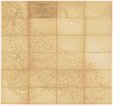
Richmond and York River Railroad

- Title
- Richmond and York River Railroad
- Description
-
"Sketch from the Confederate Engineer Bureau in Richmond, Va. General J.F. Gilmer, Chief Engineer[.] Presented to the Virginia Historical Society by his only daughter, Mrs. J.F. Minis, Sav[ana]h, Ga."--Note on map.
-
Extends from Richmond west to West Point. Also shows the course of the Pamunkey River.
-
Forms part of the Gilmer Map Collection.
-
Relief shown by hachures.
-
Available also through the Library of Congress web site as a raster image.
-
Gift of Mrs. Louisa Porter (Gilmer) Minis (i.e., Mrs. J. F. Minis), Savannah, Ga., in 1911.
-
Manuscripts o.s.
-
1 map : col. on linen ; 44 x 79 cm.
- Created Published
-
[S.l., s.n., 1864].
- Subject Headings
-
-
Gilmer, Jeremy Francis,--1818-1883--Map collection.
-
-
Richmond and York River Railroad Company.
-
-
Railroads--History--19th century.--Virginia
-
-
Virginia Peninsula (Va.)--History--Civil War, 1861-1865
-
-
United States--Virginia--Virginia Peninsula.
- Notes
-
-
"Sketch from the Confederate Engineer Bureau in Richmond, Va. General J.F. Gilmer, Chief Engineer[.] Presented to the Virginia Historical Society by his only daughter, Mrs. J.F. Minis, Sav[ana]h, Ga."--Note on map.
-
-
Extends from Richmond west to West Point. Also shows the course of the Pamunkey River.
-
-
Forms part of the Gilmer Map Collection.
-
-
Relief shown by hachures.
-
-
Available also through the Library of Congress web site as a raster image.
-
-
Gift of Mrs. Louisa Porter (Gilmer) Minis (i.e., Mrs. J. F. Minis), Savannah, Ga., in 1911.
-
-
Manuscripts o.s.
- Medium
-
1 map : col. on linen ; 44 x 79 cm.
- Repository
-
Virginia Historical Society, P.O. Box 7311, Richmond, VA 23221-0311 USA vau
- Digital Id
-
gvhs01 vhs00370 http://hdl.loc.gov/loc.ndlpcoop/gvhs01.vhs00370
Rights & Access
The maps in the Map Collections materials were either published prior to 1922, produced by the United States government, or both (see catalogue records that accompany each map for information regarding date of publication and source). The Library of Congress is providing access to these materials for educational and research purposes and is not aware of any U.S. copyright protection (see Title 17 of the United States Code) or any other restrictions in the Map Collection materials.
Note that the written permission of the copyright owners and/or other rights holders (such as publicity and/or privacy rights) is required for distribution, reproduction, or other use of protected items beyond that allowed by fair use or other statutory exemptions. Responsibility for making an independent legal assessment of an item and securing any necessary permissions ultimately rests with persons desiring to use the item.
More about Copyright and other Restrictions
For guidance about compiling full citations consult Citing Primary Sources.
Part of...
-
Civil War Maps
[2281]
-
Military Battles And Campaigns Cartographic Items
[3867]
-
Geography And Maps Division
[60803]
-
American Memory
[1121009]
More maps like this
-
 Map of New Kent, Charles City, James City and York counties.
Site:
American Memory-cultural
Original Format:
Map
Date:
1863
Map of New Kent, Charles City, James City and York counties.
Site:
American Memory-cultural
Original Format:
Map
Date:
1863
-
 The battle fields and military positions in the Virginian Peninsula, from surveys supplied by officers of the army
Contributor:
Heald, D. A.
Site:
American Memory-cultural, Main Catalog
Original Format:
Map
Date:
1862
View catalog record
The battle fields and military positions in the Virginian Peninsula, from surveys supplied by officers of the army
Contributor:
Heald, D. A.
Site:
American Memory-cultural, Main Catalog
Original Format:
Map
Date:
1862
View catalog record
-
 Map of the country between the York and James Rivers in 1862 and 1863 : showing the names of the owners of the divisions of ...
Contributor:
Thayer, Eli
Site:
American Memory-cultural
Original Format:
Map
Date:
1863
Map of the country between the York and James Rivers in 1862 and 1863 : showing the names of the owners of the divisions of ...
Contributor:
Thayer, Eli
Site:
American Memory-cultural
Original Format:
Map
Date:
1863
-
 Plan of the Rebel position at Howard's Bridge, April 4th 1862.
Contributor:
Sneden, Robert Knox
Site:
American Memory-cultural
Original Format:
Map
Date:
1862
Plan of the Rebel position at Howard's Bridge, April 4th 1862.
Contributor:
Sneden, Robert Knox
Site:
American Memory-cultural
Original Format:
Map
Date:
1862
-
 Map of the Peninsula of Virginia : showing route of McClellan's Army toward Richmond [illegible].
Contributor:
Sneden, Robert Knox
Site:
American Memory-cultural
Original Format:
Map
Date:
1862
Map of the Peninsula of Virginia : showing route of McClellan's Army toward Richmond [illegible].
Contributor:
Sneden, Robert Knox
Site:
American Memory-cultural
Original Format:
Map
Date:
1862
-
 The Rebel works at Howard's Bridge Virginia April 4th 1862.
Contributor:
Sneden, Robert Knox
Site:
American Memory-cultural
Original Format:
Map
Date:
1862
The Rebel works at Howard's Bridge Virginia April 4th 1862.
Contributor:
Sneden, Robert Knox
Site:
American Memory-cultural
Original Format:
Map
Date:
1862
-
 Map of the Lower Peninsula of Virginia, April 1862.
Contributor:
Sneden, Robert Knox
Site:
American Memory-cultural
Original Format:
Map
Date:
1862
Map of the Lower Peninsula of Virginia, April 1862.
Contributor:
Sneden, Robert Knox
Site:
American Memory-cultural
Original Format:
Map
Date:
1862
-
 The assault on the "Red Battery," April 25th, 1862 Yorktown, Va.
Contributor:
Sneden, Robert Knox
Site:
American Memory-cultural
Original Format:
Map
Date:
1862
The assault on the "Red Battery," April 25th, 1862 Yorktown, Va.
Contributor:
Sneden, Robert Knox
Site:
American Memory-cultural
Original Format:
Map
Date:
1862
-
 Extract from Fort Monroe, Norfolk, Suffolk, and Yorktown, with their connections and surroundings for military purposes /
Contributor:
Cram, Thomas Jefferson
Site:
American Memory-cultural, Main Catalog
Original Format:
Map
Date:
1862
View catalog record
Extract from Fort Monroe, Norfolk, Suffolk, and Yorktown, with their connections and surroundings for military purposes /
Contributor:
Cram, Thomas Jefferson
Site:
American Memory-cultural, Main Catalog
Original Format:
Map
Date:
1862
View catalog record
-
 Johnson's map of the vicinity of Richmond, and Peninsular Campaign in Virginia : showing also the interesting localities along the James, Chickahominy and York rivers ...
Contributor:
Johnson, A. J.
Site:
American Memory-cultural, Main Catalog
Original Format:
Map
Date:
1870
View catalog record
Johnson's map of the vicinity of Richmond, and Peninsular Campaign in Virginia : showing also the interesting localities along the James, Chickahominy and York rivers ...
Contributor:
Johnson, A. J.
Site:
American Memory-cultural, Main Catalog
Original Format:
Map
Date:
1870
View catalog record
-
 Map of the vicinity of Richmond and part of the Peninsula /
Contributor:
Campbell, Albert H.
Site:
American Memory-cultural, Main Catalog
Original Format:
Map
Date:
1864
View catalog record
Map of the vicinity of Richmond and part of the Peninsula /
Contributor:
Campbell, Albert H.
Site:
American Memory-cultural, Main Catalog
Original Format:
Map
Date:
1864
View catalog record
-
 Johnson's map of the vicinity of Richmond, and Peninsular Campaign in Virginia : showing also the interesting localities along the James, Chickahominy and York rivers ...
Contributor:
Johnson, A. J.
Site:
American Memory-cultural, Main Catalog
Original Format:
Map
Date:
1869
View catalog record
Johnson's map of the vicinity of Richmond, and Peninsular Campaign in Virginia : showing also the interesting localities along the James, Chickahominy and York rivers ...
Contributor:
Johnson, A. J.
Site:
American Memory-cultural, Main Catalog
Original Format:
Map
Date:
1869
View catalog record
-
 Map of the vicinity of Richmond and part of the Peninsula /
Contributor:
Campbell, Albert H.
Site:
American Memory-cultural, Main Catalog
Original Format:
Map
Date:
1864
View catalog record
Map of the vicinity of Richmond and part of the Peninsula /
Contributor:
Campbell, Albert H.
Site:
American Memory-cultural, Main Catalog
Original Format:
Map
Date:
1864
View catalog record
-
 [Map of the part of Virginia lying between the York and James rivers : showing battles and routes of Union forces 1861-62].
Site:
American Memory-cultural, Main Catalog
Original Format:
Map
Date:
1962
View catalog record
[Map of the part of Virginia lying between the York and James rivers : showing battles and routes of Union forces 1861-62].
Site:
American Memory-cultural, Main Catalog
Original Format:
Map
Date:
1962
View catalog record
-
 Map of the vicinity of Richmond, and part of the peninsula /
Contributor:
Gilmer, Jeremy Francis
Site:
American Memory-cultural
Original Format:
Map
Date:
1864
Map of the vicinity of Richmond, and part of the peninsula /
Contributor:
Gilmer, Jeremy Francis
Site:
American Memory-cultural
Original Format:
Map
Date:
1864
-
 Map of the vicinity of Richmond and part of the Peninsula /
Contributor:
Campbell, Albert H.
Site:
American Memory-cultural
Original Format:
Map
Date:
1864
Map of the vicinity of Richmond and part of the Peninsula /
Contributor:
Campbell, Albert H.
Site:
American Memory-cultural
Original Format:
Map
Date:
1864
You might also like
-
 [Virginia. Tracks of the Orange & Alexandria Railroad, destroyed by the Confederates between Bristow Station and the Rappahannock]
Contributor:
O'Sullivan, Timothy H.
Site:
Prints & Photographs
Original Format:
Photo, Print, Drawing
Date:
1863
[Virginia. Tracks of the Orange & Alexandria Railroad, destroyed by the Confederates between Bristow Station and the Rappahannock]
Contributor:
O'Sullivan, Timothy H.
Site:
Prints & Photographs
Original Format:
Photo, Print, Drawing
Date:
1863
-
 Remains of wreck on the track, ready for transportation to Alexandria. This train was thrown from the track by the Rebels
Contributor:
Russell, Andrew J.
Site:
Prints & Photographs, Main Catalog
Original Format:
Photo, Print, Drawing
Date:
1861
View catalog record
Remains of wreck on the track, ready for transportation to Alexandria. This train was thrown from the track by the Rebels
Contributor:
Russell, Andrew J.
Site:
Prints & Photographs, Main Catalog
Original Format:
Photo, Print, Drawing
Date:
1861
View catalog record
-
 Engine "Government" [Commodore?] down the "banks" near Brandy, April 1864
Contributor:
Russell, Andrew J.
Site:
Prints & Photographs, Main Catalog
Original Format:
Photo, Print, Drawing
Date:
1864
View catalog record
Engine "Government" [Commodore?] down the "banks" near Brandy, April 1864
Contributor:
Russell, Andrew J.
Site:
Prints & Photographs, Main Catalog
Original Format:
Photo, Print, Drawing
Date:
1864
View catalog record
-
 Grant's campaign south of the James--reinforcements to Gen. Warren arriving at the terminus of Grant's railroad near the Weldon Road, two miles and a half ...
Site:
Prints & Photographs, Main Catalog
Original Format:
Photo, Print, Drawing
Date:
1864
View catalog record
Grant's campaign south of the James--reinforcements to Gen. Warren arriving at the terminus of Grant's railroad near the Weldon Road, two miles and a half ...
Site:
Prints & Photographs, Main Catalog
Original Format:
Photo, Print, Drawing
Date:
1864
View catalog record
-
 Destruction of bridge telegraph tanks Etc. in Warrenton Junction
Contributor:
Waud, Alfred R. (Alfred Rudolph), Waud, Alfred R.
Site:
Prints & Photographs, Main Catalog
Original Format:
Photo, Print, Drawing
Date:
1863
View catalog record
Destruction of bridge telegraph tanks Etc. in Warrenton Junction
Contributor:
Waud, Alfred R. (Alfred Rudolph), Waud, Alfred R.
Site:
Prints & Photographs, Main Catalog
Original Format:
Photo, Print, Drawing
Date:
1863
View catalog record
-
 [Manassas, Va. Orange and Alexandria Railroad wrecked by retreating Confederates]
Contributor:
Barnard, George N., Gibson, James F.
Site:
Prints & Photographs
Original Format:
Photo, Print, Drawing
Date:
1862
[Manassas, Va. Orange and Alexandria Railroad wrecked by retreating Confederates]
Contributor:
Barnard, George N., Gibson, James F.
Site:
Prints & Photographs
Original Format:
Photo, Print, Drawing
Date:
1862