Map
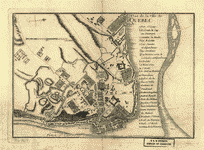
Carte de l'Amerique Septentrionnale : depuis le 25, jusqu'au 65p0s deg. de latt. & environ 140, & 235 deg. de longitude / par Iean Baptiste Louis Franquelin, hydrographe du roy, à Québec en Canada.

| Format |
Map |
|---|---|
| Contributors |
Franquelin, Jean Baptiste Louis |
| Dates |
1909 |
| Location |
Canada North America QuéBec QuéBec |
| Language |
French |
| Subjects |
Canada North America QuéBec QuéBec (QuéBec) |
- Title
- Carte de l'Amerique Septentrionnale : depuis le 25, jusqu'au 65p0s deg. de latt. & environ 140, & 235 deg. de longitude / par Iean Baptiste Louis Franquelin, hydrographe du roy, à Québec en Canada.
- Description
-
Copied between 1909 and 1910 from the original 1688 ms. in the Archives du dépôt des cartes et plans de la marine.
-
Pen-and-ink and watercolor.
-
In margin: Bibliotheque du Depot des cartes et plans de la Marina, Paris, Atlas 4040B, piece n. 3.
-
Includes indexed inset of view "Quebec comme il se voit du cóté de l'est."
-
Available also through the Library of Congress Web site as a raster image.
-
1 ms. map : col. ; 103 x 160 cm.
-
Copied between 1909 and 1910 from the original 1688 ms. in the Archives du dépôt des cartes et plans de la marine.
-
Includes indexed inset of view "Quebec comme il se voit du cóté de l'est."
- Creator
- Franquelin, Jean Baptiste Louis.
- Created Published
-
[1909 or 1910]
- Subject Headings
-
-
North America
-
-
Québec (Québec)
-
-
Québec (Québec)
-
-
North America.
-
-
Canada--Québec--Québec.
- Notes
-
-
Copied between 1909 and 1910 from the original 1688 ms. in the Archives du dépôt des cartes et plans de la marine.
-
-
Pen-and-ink and watercolor.
-
-
In margin: Bibliotheque du Depot des cartes et plans de la Marina, Paris, Atlas 4040B, piece n. 3.
-
-
Includes indexed inset of view "Quebec comme il se voit du cóté de l'est."
-
-
Available also through the Library of Congress Web site as a raster image.
- Medium
-
1 ms. map : col. ; 103 x 160 cm.
- Call Number
-
G3300 1688 .F7
- Repository
-
Library of Congress Geography and Map Division Washington, D.C. 20540-4650 USA dcu
- Digital Id
-
g3300 ct000668 http://hdl.loc.gov/loc.gmd/g3300.ct000668
- Library of Congress Catalog Number
- 2002622264
Rights & Access
The maps in the Map Collections materials were either published prior to 1922, produced by the United States government, or both (see catalogue records that accompany each map for information regarding date of publication and source). The Library of Congress is providing access to these materials for educational and research purposes and is not aware of any U.S. copyright protection (see Title 17 of the United States Code) or any other restrictions in the Map Collection materials.
Note that the written permission of the copyright owners and/or other rights holders (such as publicity and/or privacy rights) is required for distribution, reproduction, or other use of protected items beyond that allowed by fair use or other statutory exemptions. Responsibility for making an independent legal assessment of an item and securing any necessary permissions ultimately rests with persons desiring to use the item.
More about Copyright and other Restrictions
For guidance about compiling full citations consult Citing Primary Sources.
Part of...
-
Louisiana: European Explorations And The Louisiana Purchase
[77]
-
Discovery And Exploration
[150]
-
Geography And Maps Division
[60803]
-
American Memory
[1121009]
More maps like this
-
 Amérique septentrion.lle [i.e. septentrionale] : composée, corigée, et augmētée, sur les iournaux, mémoires, et observations les plus justes qui en ón'́etes.tes en l'année 1685 & ...
Contributor:
Franquelin, Jean Baptiste Louis
Site:
American Memory-cultural, Main Catalog
Original Format:
Map
Date:
1685
View catalog record
Amérique septentrion.lle [i.e. septentrionale] : composée, corigée, et augmētée, sur les iournaux, mémoires, et observations les plus justes qui en ón'́etes.tes en l'année 1685 & ...
Contributor:
Franquelin, Jean Baptiste Louis
Site:
American Memory-cultural, Main Catalog
Original Format:
Map
Date:
1685
View catalog record
-
 Franquelin's map of Louisiana.
Contributor:
Franquelin, Jean Baptiste Louis
Site:
American Memory-cultural, Main Catalog
Original Format:
Map
Date:
1896
View catalog record
Franquelin's map of Louisiana.
Contributor:
Franquelin, Jean Baptiste Louis
Site:
American Memory-cultural, Main Catalog
Original Format:
Map
Date:
1896
View catalog record
-
 A new and accurate map of the English empire in North America; Representing their rightful claim as confirmed by charters and the formal surrender of ...
Contributor:
Society of Anti-Gallicans
Site:
American Memory-cultural, Main Catalog
Original Format:
Map
Date:
1755
View catalog record
A new and accurate map of the English empire in North America; Representing their rightful claim as confirmed by charters and the formal surrender of ...
Contributor:
Society of Anti-Gallicans
Site:
American Memory-cultural, Main Catalog
Original Format:
Map
Date:
1755
View catalog record
-
 Plan of Quebec, the capital of Canada in North America, with the bason and part of the adjacent contry [sic] shewing the principal encampments and ...
Site:
American Memory-cultural, Main Catalog
Original Format:
Map
Date:
1759
View catalog record
Plan of Quebec, the capital of Canada in North America, with the bason and part of the adjacent contry [sic] shewing the principal encampments and ...
Site:
American Memory-cultural, Main Catalog
Original Format:
Map
Date:
1759
View catalog record
-
 Vue de Quebec, capitale du Canada.
Contributor:
Le Rouge, Georges-Louis
Site:
American Memory-cultural, Main Catalog
Original Format:
Map
Date:
1755
View catalog record
Vue de Quebec, capitale du Canada.
Contributor:
Le Rouge, Georges-Louis
Site:
American Memory-cultural, Main Catalog
Original Format:
Map
Date:
1755
View catalog record
-
 Plan de la ville de Québec.
Site:
American Memory-cultural, Main Catalog
Original Format:
Map
Date:
1750
View catalog record
Plan de la ville de Québec.
Site:
American Memory-cultural, Main Catalog
Original Format:
Map
Date:
1750
View catalog record
-
 Plan du terrain sur le cap appartenant à la paroise de cette uille 1756.
Contributor:
Lamoville, Lemaitre
Site:
American Memory-cultural, Main Catalog
Original Format:
Map
Date:
1756
View catalog record
Plan du terrain sur le cap appartenant à la paroise de cette uille 1756.
Contributor:
Lamoville, Lemaitre
Site:
American Memory-cultural, Main Catalog
Original Format:
Map
Date:
1756
View catalog record
-
 Qubbec, ville de l'Amerique septentrionale dans la Nouvelle France avec titre d'Eveché située sur le fleuve de St. Laurens a 310 degrez 17 minutes de ...
Contributor:
Aubant, Abraham d
Site:
American Memory-cultural, Main Catalog
Original Format:
Map
Date:
1755
View catalog record
Qubbec, ville de l'Amerique septentrionale dans la Nouvelle France avec titre d'Eveché située sur le fleuve de St. Laurens a 310 degrez 17 minutes de ...
Contributor:
Aubant, Abraham d
Site:
American Memory-cultural, Main Catalog
Original Format:
Map
Date:
1755
View catalog record
-
 Plan de la ville de Quebec.
Contributor:
Le Rouge, Georges-Louis
Site:
American Memory-cultural, Main Catalog
Original Format:
Map
Date:
1755
View catalog record
Plan de la ville de Quebec.
Contributor:
Le Rouge, Georges-Louis
Site:
American Memory-cultural, Main Catalog
Original Format:
Map
Date:
1755
View catalog record
-
 Environs de Quebec: Bloque par les Americains du 8. decembre 1775 au 13. mai 1776.
Contributor:
Le Rouge, Georges-Louis
Site:
American Memory-cultural, Main Catalog
Original Format:
Map
Date:
1777
View catalog record
Environs de Quebec: Bloque par les Americains du 8. decembre 1775 au 13. mai 1776.
Contributor:
Le Rouge, Georges-Louis
Site:
American Memory-cultural, Main Catalog
Original Format:
Map
Date:
1777
View catalog record
-
 The Mississippi /
Contributor:
Franquelin, Jean Baptiste Louis
Site:
American Memory-cultural, Main Catalog
Original Format:
Map
Date:
1682
View catalog record
The Mississippi /
Contributor:
Franquelin, Jean Baptiste Louis
Site:
American Memory-cultural, Main Catalog
Original Format:
Map
Date:
1682
View catalog record
-
 This map of the province of Nova-Scotia and parts adjacent.
Contributor:
Turner, James
Site:
American Memory-cultural, Main Catalog
Original Format:
Map
Date:
1776
View catalog record
This map of the province of Nova-Scotia and parts adjacent.
Contributor:
Turner, James
Site:
American Memory-cultural, Main Catalog
Original Format:
Map
Date:
1776
View catalog record
-
 A plan of a survey made to explore the country for a road between Connecticut River & St. Francis.
Contributor:
[Finlay, Hugh]
Site:
American Memory-cultural, Main Catalog
Original Format:
Map
Date:
1774
View catalog record
A plan of a survey made to explore the country for a road between Connecticut River & St. Francis.
Contributor:
[Finlay, Hugh]
Site:
American Memory-cultural, Main Catalog
Original Format:
Map
Date:
1774
View catalog record
-
 Plan of the route from St. Francis to Connecticut River,
Contributor:
Finlay, Hugh
Site:
American Memory-cultural, Main Catalog
Original Format:
Map
Date:
1774
View catalog record
Plan of the route from St. Francis to Connecticut River,
Contributor:
Finlay, Hugh
Site:
American Memory-cultural, Main Catalog
Original Format:
Map
Date:
1774
View catalog record
-
 Bird's eye view of Sherbrooke, P.Q.
Site:
American Memory-cultural, Main Catalog
Original Format:
Map
Date:
1881
View catalog record
Bird's eye view of Sherbrooke, P.Q.
Site:
American Memory-cultural, Main Catalog
Original Format:
Map
Date:
1881
View catalog record
-
 A map shewing the communication of the lakes and the rivers between Lake Superior and Slave Lake in North America.
Contributor:
Pond, Peter
Site:
American Memory-cultural, Main Catalog
Original Format:
Map
Date:
1790
View catalog record
A map shewing the communication of the lakes and the rivers between Lake Superior and Slave Lake in North America.
Contributor:
Pond, Peter
Site:
American Memory-cultural, Main Catalog
Original Format:
Map
Date:
1790
View catalog record
You might also like
-
 General Wolfe killed at the siege of Quebec, September 14,1759
Site:
Prints & Photographs, Main Catalog
Original Format:
Photo, Print, Drawing
Date:
1792
View catalog record
General Wolfe killed at the siege of Quebec, September 14,1759
Site:
Prints & Photographs, Main Catalog
Original Format:
Photo, Print, Drawing
Date:
1792
View catalog record
-
 Mort de Montcalm
Site:
Prints & Photographs, Main Catalog
Original Format:
Photo, Print, Drawing
Date:
1759
View catalog record
Mort de Montcalm
Site:
Prints & Photographs, Main Catalog
Original Format:
Photo, Print, Drawing
Date:
1759
View catalog record
-
 A View of the taking of Quebeck by the English forces commanded by Gen. Wolfe, Sep: 13th, 1759
Site:
Prints & Photographs, Main Catalog
Original Format:
Photo, Print, Drawing
Date:
1760
View catalog record
A View of the taking of Quebeck by the English forces commanded by Gen. Wolfe, Sep: 13th, 1759
Site:
Prints & Photographs, Main Catalog
Original Format:
Photo, Print, Drawing
Date:
1760
View catalog record
-
-

 The Yankee in Quebec,
Contributor:
Gard, Anson A[lbert]
Site:
Main Catalog
Original Format:
Book
Date:
1901
The Yankee in Quebec,
Contributor:
Gard, Anson A[lbert]
Site:
Main Catalog
Original Format:
Book
Date:
1901
-
The Yankee in Quebec,
Contributor:
Gard, Anson A.
Site:
Main Catalog
Original Format:
Book
Date:
1901
