Map
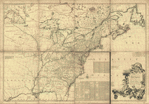
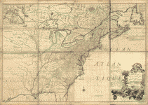
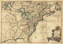
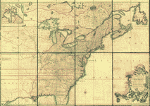
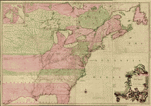
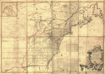
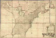
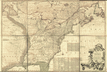
A map of the British and French dominions in North America, with the roads, distances, limits, and extent of the settlements, humbly inscribed to the Right Honourable the Earl of Halifax, and the other Right Honourable the Lords Commissioners for Trade & Plantations,

| Format |
Map |
|---|---|
| Contributors |
Mitchell, John |
| Dates |
1774 |
| Location |
America North America |
| Language |
English |
| Subjects |
America British North America |
- Title
- A map of the British and French dominions in North America, with the roads, distances, limits, and extent of the settlements, humbly inscribed to the Right Honourable the Earl of Halifax, and the other Right Honourable the Lords Commissioners for Trade & Plantations,
- Description
-
Scale ca. 1:2,000,000.
-
Hand colored.
-
Second impression of 3d ed.
-
Relief shown pictorially.
-
LC Maps of North America, 1750-1789, 42
-
Includes text and inset "A new map of Hudson's Bay and Labrador from the late surveys of those coasts."
-
On verso in manuscript "Map of the British and French [sic] dominions in North America."
-
Available also through the Library of Congress Web site as a raster image.
-
col. map 136 x 195 cm.
- Creator
- Mitchell, John,
- Created Published
-
London, Printed for Jefferys and Faden, geographers to the King [1774]
- Subject Headings
-
-
North America
-
-
British--America
-
-
North America.
- Notes
-
-
Scale ca. 1:2,000,000.
-
-
Hand colored.
-
-
Second impression of 3d ed.
-
-
Relief shown pictorially.
-
-
LC Maps of North America, 1750-1789, 42
-
-
Includes text and inset "A new map of Hudson's Bay and Labrador from the late surveys of those coasts."
-
-
On verso in manuscript "Map of the British and French [sic] dominions in North America."
-
-
Available also through the Library of Congress Web site as a raster image.
- Medium
-
col. map 136 x 195 cm.
- Call Number
-
G3300 1774 .M5
- Repository
-
Library of Congress Geography and Map Division Washington, D.C. 20540-4650 USA dcu
- Digital Id
-
g3300 ar004200 http://hdl.loc.gov/loc.gmd/g3300.ar004200
- Library of Congress Catalog Number
- 74693177
Rights & Access
The maps in the Map Collections materials were either published prior to 1922, produced by the United States government, or both (see catalogue records that accompany each map for information regarding date of publication and source). The Library of Congress is providing access to these materials for educational and research purposes and is not aware of any U.S. copyright protection (see Title 17 of the United States Code) or any other restrictions in the Map Collection materials.
Note that the written permission of the copyright owners and/or other rights holders (such as publicity and/or privacy rights) is required for distribution, reproduction, or other use of protected items beyond that allowed by fair use or other statutory exemptions. Responsibility for making an independent legal assessment of an item and securing any necessary permissions ultimately rests with persons desiring to use the item.
More about Copyright and other Restrictions
For guidance about compiling full citations consult Citing Primary Sources.
Part of...
More maps like this
-
 A map of the British and French dominions in North America, with the roads, distances, limits, and extent of the settlements, humbly inscribed to the ...
Contributor:
Mitchell, John
Site:
American Memory-cultural, Main Catalog
Original Format:
Map
Date:
1773
View catalog record
A map of the British and French dominions in North America, with the roads, distances, limits, and extent of the settlements, humbly inscribed to the ...
Contributor:
Mitchell, John
Site:
American Memory-cultural, Main Catalog
Original Format:
Map
Date:
1773
View catalog record
-
 Amérique septentrionale avec les routes, distances en miles, villages, et etablissements françois et anglois,
Contributor:
Mitchell, John
Site:
American Memory-cultural, Main Catalog
Original Format:
Map
Date:
1776
View catalog record
Amérique septentrionale avec les routes, distances en miles, villages, et etablissements françois et anglois,
Contributor:
Mitchell, John
Site:
American Memory-cultural, Main Catalog
Original Format:
Map
Date:
1776
View catalog record
-
 Amérique septentrionale avec les routes, distances en miles, villages et etablissements françois et anglois,
Contributor:
Mitchell, John
Site:
American Memory-cultural, Main Catalog
Original Format:
Map
Date:
1792
View catalog record
Amérique septentrionale avec les routes, distances en miles, villages et etablissements françois et anglois,
Contributor:
Mitchell, John
Site:
American Memory-cultural, Main Catalog
Original Format:
Map
Date:
1792
View catalog record
-
 Amérique septentrionale avec les routes, distances en miles, villages et etablissements françois et anglois,
Contributor:
Mitchell, John
Site:
American Memory-cultural, Main Catalog
Original Format:
Map
Date:
1777
View catalog record
Amérique septentrionale avec les routes, distances en miles, villages et etablissements françois et anglois,
Contributor:
Mitchell, John
Site:
American Memory-cultural, Main Catalog
Original Format:
Map
Date:
1777
View catalog record
-
 A map of the British and French dominions in North America with the roads, distances, limits, and extent of the settlements, humbly inscribed to the ...
Contributor:
Mitchell, John
Site:
American Memory-cultural, Main Catalog
Original Format:
Map
Date:
1755
View catalog record
A map of the British and French dominions in North America with the roads, distances, limits, and extent of the settlements, humbly inscribed to the ...
Contributor:
Mitchell, John
Site:
American Memory-cultural, Main Catalog
Original Format:
Map
Date:
1755
View catalog record
-
 A map of the British and French dominions in North America, with the roads, distances, limits, and extent of the settlements, humbly inscribed to the ...
Contributor:
Mitchell, John
Site:
American Memory-cultural, Main Catalog
Original Format:
Map
Date:
1755
View catalog record
A map of the British and French dominions in North America, with the roads, distances, limits, and extent of the settlements, humbly inscribed to the ...
Contributor:
Mitchell, John
Site:
American Memory-cultural, Main Catalog
Original Format:
Map
Date:
1755
View catalog record
-
 A map of the British and French dominions in North America, with the roads, distances, limits, and extent of the settlements, humbly inscribed to the ...
Contributor:
Mitchell, John
Site:
American Memory-cultural, Main Catalog
Original Format:
Map
Date:
1757
View catalog record
A map of the British and French dominions in North America, with the roads, distances, limits, and extent of the settlements, humbly inscribed to the ...
Contributor:
Mitchell, John
Site:
American Memory-cultural, Main Catalog
Original Format:
Map
Date:
1757
View catalog record
-
 Amérique septentrionale avec les routes, distances en miles, limites et etablissements françois et anglois,
Contributor:
Mitchell, John
Site:
American Memory-cultural, Main Catalog
Original Format:
Map
Date:
1756
View catalog record
Amérique septentrionale avec les routes, distances en miles, limites et etablissements françois et anglois,
Contributor:
Mitchell, John
Site:
American Memory-cultural, Main Catalog
Original Format:
Map
Date:
1756
View catalog record
-
 Amérique septentrionale avec les routes, distances en miles, villages et etablissements françois et anglois,
Contributor:
Mitchell, John
Site:
American Memory-cultural, Main Catalog
Original Format:
Map
Date:
1777
View catalog record
Amérique septentrionale avec les routes, distances en miles, villages et etablissements françois et anglois,
Contributor:
Mitchell, John
Site:
American Memory-cultural, Main Catalog
Original Format:
Map
Date:
1777
View catalog record
-
 Amérique septentrionale avec les routes, distances en miles, villages et etablissements françois et anglois,
Contributor:
Mitchell, John
Site:
American Memory-cultural, Main Catalog
Original Format:
Map
Date:
1756
View catalog record
Amérique septentrionale avec les routes, distances en miles, villages et etablissements françois et anglois,
Contributor:
Mitchell, John
Site:
American Memory-cultural, Main Catalog
Original Format:
Map
Date:
1756
View catalog record
-
 A map of the British and French dominions in North America, with the roads, distances, limits, and extent of the settlements,
Contributor:
Mitchell, John
Site:
American Memory-cultural, Main Catalog
Original Format:
Map
Date:
1755
View catalog record
A map of the British and French dominions in North America, with the roads, distances, limits, and extent of the settlements,
Contributor:
Mitchell, John
Site:
American Memory-cultural, Main Catalog
Original Format:
Map
Date:
1755
View catalog record
-
 Amérique septentrionale avec les routes, distances en miles, villages, et etablissements françois et anglois,
Contributor:
Mitchell, John
Site:
American Memory-cultural, Main Catalog
Original Format:
Map
Date:
1777
View catalog record
Amérique septentrionale avec les routes, distances en miles, villages, et etablissements françois et anglois,
Contributor:
Mitchell, John
Site:
American Memory-cultural, Main Catalog
Original Format:
Map
Date:
1777
View catalog record
-
 A map of the British and French dominions in North America, with the roads, distances, limits, and extent of the settlements, humbly inscribed to the ...
Contributor:
Mitchell, John
Site:
American Memory-cultural, Main Catalog
Original Format:
Map
Date:
1755
View catalog record
A map of the British and French dominions in North America, with the roads, distances, limits, and extent of the settlements, humbly inscribed to the ...
Contributor:
Mitchell, John
Site:
American Memory-cultural, Main Catalog
Original Format:
Map
Date:
1755
View catalog record
-
 A map of the British colonies in North America, with the roads, distances, limits, and extent of the settlements, humbly inscribed to the Right Honourable ...
Contributor:
Mitchell, John
Site:
American Memory-cultural, Main Catalog
Original Format:
Map
Date:
1775
View catalog record
A map of the British colonies in North America, with the roads, distances, limits, and extent of the settlements, humbly inscribed to the Right Honourable ...
Contributor:
Mitchell, John
Site:
American Memory-cultural, Main Catalog
Original Format:
Map
Date:
1775
View catalog record
-
 An accurate map of the British colonies in North America bordering on the river Ohio.
Contributor:
Overton, Henry, firm, London
Site:
American Memory-cultural, Main Catalog
Original Format:
Map
Date:
1755
View catalog record
An accurate map of the British colonies in North America bordering on the river Ohio.
Contributor:
Overton, Henry, firm, London
Site:
American Memory-cultural, Main Catalog
Original Format:
Map
Date:
1755
View catalog record
-
 An accurate map of North America describing and distinguishing the British and French dominions on this great continent according to the definitive treaty concluded at ...
Contributor:
Sayer, Robert
Site:
American Memory-cultural, Main Catalog
Original Format:
Map
Date:
1763
View catalog record
An accurate map of North America describing and distinguishing the British and French dominions on this great continent according to the definitive treaty concluded at ...
Contributor:
Sayer, Robert
Site:
American Memory-cultural, Main Catalog
Original Format:
Map
Date:
1763
View catalog record
You might also like
-
-
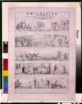
 Emigration--Detailing the progress and vicissitudes of an emigrant
Contributor:
Grant, C. J.
Site:
Prints & Photographs, Main Catalog
Original Format:
Photo, Print, Drawing
Date:
1834
View catalog record
Emigration--Detailing the progress and vicissitudes of an emigrant
Contributor:
Grant, C. J.
Site:
Prints & Photographs, Main Catalog
Original Format:
Photo, Print, Drawing
Date:
1834
View catalog record
-
 Emigration--Detailing the progress and vicissitudes of an emigrant
Contributor:
Grant, C. J.
Site:
Prints & Photographs, Main Catalog
Original Format:
Photo, Print, Drawing
Date:
1833
View catalog record
Emigration--Detailing the progress and vicissitudes of an emigrant
Contributor:
Grant, C. J.
Site:
Prints & Photographs, Main Catalog
Original Format:
Photo, Print, Drawing
Date:
1833
View catalog record
-

 Columbus and other heroes of American discovery;
Contributor:
D'Anvers, N.
Site:
Main Catalog
Original Format:
Book
Date:
1893
Columbus and other heroes of American discovery;
Contributor:
D'Anvers, N.
Site:
Main Catalog
Original Format:
Book
Date:
1893
-
The romance of discovery; a thousand years of exploration and the unveiling of continents,
Contributor:
Griffis, William Elliot
Site:
Main Catalog
Original Format:
Book
Date:
1897
-
American journeys eyewitness accounts of early American exploration and settlement : a digital library and learning center.
Site:
Main Catalog
Original Format:
Book
Date:
2003