Map
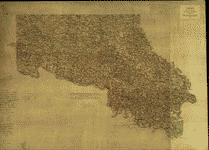
[Map of parts of Caroline, Hanover, and Henrico counties, Va., west of the Mattaponi River and the Richmond, Fredericksburg, and Potomac Railroad].

- Title
- [Map of parts of Caroline, Hanover, and Henrico counties, Va., west of the Mattaponi River and the Richmond, Fredericksburg, and Potomac Railroad].
- Description
-
Shows the names of some residents, some of the outer fortifications of Richmond and those along the railroad north of the South Anna River.
-
Date, title, and scale from Stephenson's Civil War maps, 1989.
-
Pen-and-ink, mounted on cloth.
-
LC Civil War maps (2nd ed.), H25
-
LC Land ownership maps, 1233
-
Available also through the Library of Congress web site as raster image.
-
Imperfect: staining on the lower right section of the sheet.
-
1 map : col. ms. ; 27 x 28 cm.
- Created Published
-
[186-]
- Subject Headings
-
-
Caroline County (Va.)
-
-
Hanover County (Va.)
-
-
Henrico County (Va.)
-
-
Landowners--Virginia--Caroline County
-
-
Landowners--Virginia--Hanover County
-
-
Landowners--Virginia--Henrico County
-
-
United States--Virginia--Caroline County.
-
-
United States--Virginia--Hanover County.
-
-
United States--Virginia--Henrico County.
- Notes
-
-
Shows the names of some residents, some of the outer fortifications of Richmond and those along the railroad north of the South Anna River.
-
-
Date, title, and scale from Stephenson's Civil War maps, 1989.
-
-
Pen-and-ink, mounted on cloth.
-
-
LC Civil War maps (2nd ed.), H25
-
-
LC Land ownership maps, 1233
-
-
Available also through the Library of Congress web site as raster image.
-
-
Imperfect: staining on the lower right section of the sheet.
- Medium
-
1 map : col. ms. ; 27 x 28 cm.
- Call Number
-
G3883.C3 186- .M2
- Repository
-
Library of Congress Geography and Map Division Washington, D.C. 20540-4650 dcu
- Digital Id
-
g3883c cwh00025 http://hdl.loc.gov/loc.gmd/g3883c.cwh00025
- Library of Congress Catalog Number
- 2002627430
Rights & Access
The maps in the Map Collections materials were either published prior to 1922, produced by the United States government, or both (see catalogue records that accompany each map for information regarding date of publication and source). The Library of Congress is providing access to these materials for educational and research purposes and is not aware of any U.S. copyright protection (see Title 17 of the United States Code) or any other restrictions in the Map Collection materials.
Note that the written permission of the copyright owners and/or other rights holders (such as publicity and/or privacy rights) is required for distribution, reproduction, or other use of protected items beyond that allowed by fair use or other statutory exemptions. Responsibility for making an independent legal assessment of an item and securing any necessary permissions ultimately rests with persons desiring to use the item.
More about Copyright and other Restrictions
For guidance about compiling full citations consult Citing Primary Sources.
Part of...
-
Hotchkiss Map Collection
[345]
-
Cultural Landscapes
[1623]
-
Civil War Maps
[2281]
-
Military Battles And Campaigns Cartographic Items
[3867]
-
Geography And Maps Division
[60803]
-
American Memory
[1121009]
More maps like this
-
 [Map of Henrico, Hanover and Caroline counties.]
Site:
American Memory-cultural, Main Catalog
Original Format:
Map
Date:
1864
View catalog record
[Map of Henrico, Hanover and Caroline counties.]
Site:
American Memory-cultural, Main Catalog
Original Format:
Map
Date:
1864
View catalog record
-
 [White House to Harrisons Landing].
Contributor:
Abbot, Henry L.
Site:
American Memory-cultural
Original Format:
Map
[White House to Harrisons Landing].
Contributor:
Abbot, Henry L.
Site:
American Memory-cultural
Original Format:
Map
-
 Map of the counties of Charles City, Goochland, Hanover, Henrico, King William, New Kent, and part of the counties of Caroline and Louisa, Virginia.
Site:
American Memory-cultural
Original Format:
Map
Date:
1864
Map of the counties of Charles City, Goochland, Hanover, Henrico, King William, New Kent, and part of the counties of Caroline and Louisa, Virginia.
Site:
American Memory-cultural
Original Format:
Map
Date:
1864
-
 Col. William Allen's map of the vicinity of Hanover Junction.
Contributor:
Allen, William Wirt
Site:
American Memory-cultural, Main Catalog
Original Format:
Map
Date:
1864
View catalog record
Col. William Allen's map of the vicinity of Hanover Junction.
Contributor:
Allen, William Wirt
Site:
American Memory-cultural, Main Catalog
Original Format:
Map
Date:
1864
View catalog record
-
 [Map of Hanover County, Va.].
Site:
American Memory-cultural, Main Catalog
Original Format:
Map
View catalog record
[Map of Hanover County, Va.].
Site:
American Memory-cultural, Main Catalog
Original Format:
Map
View catalog record
-
 Caroline County, Virginia /
Site:
American Memory-cultural, Main Catalog
Original Format:
Map
View catalog record
Caroline County, Virginia /
Site:
American Memory-cultural, Main Catalog
Original Format:
Map
View catalog record
-
 Map of Caroline County, Va. /
Contributor:
Campbell, Albert H.
Site:
American Memory-cultural, Main Catalog
Original Format:
Map
Date:
1862
View catalog record
Map of Caroline County, Va. /
Contributor:
Campbell, Albert H.
Site:
American Memory-cultural, Main Catalog
Original Format:
Map
Date:
1862
View catalog record
-
 [Map of the northern portion of Hanover County, Va., showing fortifications on the South Anna River near Taylorsville].
Site:
American Memory-cultural, Main Catalog
Original Format:
Map
View catalog record
[Map of the northern portion of Hanover County, Va., showing fortifications on the South Anna River near Taylorsville].
Site:
American Memory-cultural, Main Catalog
Original Format:
Map
View catalog record
-
 Map showing the lines of entrenchments of the C.S. Army of Northern Va., [exten]ding from the Totopotomoy to the Chickahominy, and the positions of the ...
Contributor:
Hotchkiss, Jedediah
Site:
American Memory-cultural, Main Catalog
Original Format:
Map
Date:
1864-06-10
View catalog record
Map showing the lines of entrenchments of the C.S. Army of Northern Va., [exten]ding from the Totopotomoy to the Chickahominy, and the positions of the ...
Contributor:
Hotchkiss, Jedediah
Site:
American Memory-cultural, Main Catalog
Original Format:
Map
Date:
1864-06-10
View catalog record
-
 Map showing the line of entrenchments of the Army N. Va. from Totopotomoy to the Chickahominy and the positions of the 2nd Corps, A.N.V. from ...
Site:
American Memory-cultural, Main Catalog
Original Format:
Map
Date:
1864
View catalog record
Map showing the line of entrenchments of the Army N. Va. from Totopotomoy to the Chickahominy and the positions of the 2nd Corps, A.N.V. from ...
Site:
American Memory-cultural, Main Catalog
Original Format:
Map
Date:
1864
View catalog record
-
 [Map of Louisa County and part of Hanover County, Va.].
Site:
American Memory-cultural, Main Catalog
Original Format:
Map
View catalog record
[Map of Louisa County and part of Hanover County, Va.].
Site:
American Memory-cultural, Main Catalog
Original Format:
Map
View catalog record
-
 [Map of Hanover County, Va.].
Site:
American Memory-cultural, Main Catalog
Original Format:
Map
View catalog record
[Map of Hanover County, Va.].
Site:
American Memory-cultural, Main Catalog
Original Format:
Map
View catalog record
-
 [Map of Spotsylvania and Caroline Counties, Virginia].
Site:
American Memory-cultural, Main Catalog
Original Format:
Map
View catalog record
[Map of Spotsylvania and Caroline Counties, Virginia].
Site:
American Memory-cultural, Main Catalog
Original Format:
Map
View catalog record
-
 Map of Henrico County, Virginia : showing portions of Chesterfield County also City of Richmond /
Contributor:
T. Crawford Redd & Brother
Site:
American Memory-cultural, Main Catalog
Original Format:
Map
Date:
1911
View catalog record
Map of Henrico County, Virginia : showing portions of Chesterfield County also City of Richmond /
Contributor:
T. Crawford Redd & Brother
Site:
American Memory-cultural, Main Catalog
Original Format:
Map
Date:
1911
View catalog record
-
 Map of Henrico County, Virginia /
Contributor:
T. Crawford Redd & Brother
Site:
American Memory-cultural, Main Catalog
Original Format:
Map
Date:
1916
View catalog record
Map of Henrico County, Virginia /
Contributor:
T. Crawford Redd & Brother
Site:
American Memory-cultural, Main Catalog
Original Format:
Map
Date:
1916
View catalog record
-
 Map of the upper District of Henrico County ; Map of the Lower District of Henrico County /
Contributor:
Redd, James T.
Site:
American Memory-cultural, Main Catalog
Original Format:
Map
Date:
1887
View catalog record
Map of the upper District of Henrico County ; Map of the Lower District of Henrico County /
Contributor:
Redd, James T.
Site:
American Memory-cultural, Main Catalog
Original Format:
Map
Date:
1887
View catalog record
You might also like
-

 A handbook of Caroline County, Virginia.
Contributor:
Caroline County (Va.). Board of Supervisors
Site:
Main Catalog
Original Format:
Book
Date:
1907
A handbook of Caroline County, Virginia.
Contributor:
Caroline County (Va.). Board of Supervisors
Site:
Main Catalog
Original Format:
Book
Date:
1907
-
To the voters of Caroline County.
Contributor:
[Hord, Robert]
Site:
Main Catalog
Original Format:
Book
Date:
1835
-
Bacteria TMDL for Tuckahoe Creek, Little Tuckahoe Creek, Anderson, Broad, Georges and Readers Branches, and Deep Run, Henrico, Goochland and Hanover Counties, Virginia /
Site:
Main Catalog
Original Format:
Book
Date:
2004
-
New Kent County and Hanover County Road Orders, 1706-1743 : transcribed from the vestry book of St. Paul's Parish /
Contributor:
Miller, Ann Brush
Site:
Main Catalog
Original Format:
Book
Date:
2004
-
Our Quaker Friends of ye olden time; being in part a transcript of the minute books of Cedar Creek meeting, Hanover County, and the South ...
Contributor:
[Bell, James Pinkney Pleasant]
Site:
Main Catalog
Original Format:
Book
Date:
1905
-
Total maximum daily load (TMDL) development for the unnamed tributary to the Chickahominy River : aquatic life use (benthic) impairment /
Site:
Main Catalog
Original Format:
Book
Date:
2004