Map
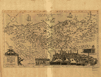
Modern Palestine showing the physical features and identified states /
Views

| Format |
Map |
|---|---|
| Contributors |
George Philip & Son |
| Dates |
1915 |
| Location |
Jerusalem Palestine |
| Language |
English |
| Subjects |
Jerusalem Palestine |
- Title
- Modern Palestine showing the physical features and identified states /
- Description
-
Relief shown by gradient tints, hachures, and spot heights. Depths shown by gradient tints.
-
Available also through the Library of Congress Web site as a raster image.
-
Includes indexed map of "Modern Jerusalem".
-
LC copy sectioned in two and mounted on cloth. lcgft
-
1 map : color ; 106 x 89 cm
- Creator
- George Philip & Son.
- Created Published
-
New York : C.S. Hammond and Co., Publishers, [1915?]
- Subject Headings
-
-
Palestine
-
-
Jerusalem
-
-
Palestine.
-
-
Jerusalem.
- Notes
-
-
Relief shown by gradient tints, hachures, and spot heights. Depths shown by gradient tints.
-
-
Available also through the Library of Congress Web site as a raster image.
-
-
Includes indexed map of "Modern Jerusalem".
-
-
LC copy sectioned in two and mounted on cloth. lcgft
- Medium
-
1 map : color ; 106 x 89 cm
- Call Number
-
G7501.C2 1915 .U5
- Repository
-
Library of Congress Geography and Map Division Washington, D.C. 20540-4650 USA dcu
- Digital Id
-
g7501c ct003105 http://hdl.loc.gov/loc.gmd/g7501c.ct003105
- Library of Congress Catalog Number
- 2012586637
Rights & Access
The maps in the Map Collections materials were either published prior to 1922, produced by the United States government, or both (see catalogue records that accompany each map for information regarding date of publication and source). The Library of Congress is providing access to these materials for educational and research purposes and is not aware of any U.S. copyright protection (see Title 17 of the United States Code) or any other restrictions in the Map Collection materials.
Note that the written permission of the copyright owners and/or other rights holders (such as publicity and/or privacy rights) is required for distribution, reproduction, or other use of protected items beyond that allowed by fair use or other statutory exemptions. Responsibility for making an independent legal assessment of an item and securing any necessary permissions ultimately rests with persons desiring to use the item.
More about Copyright and other Restrictions
For guidance about compiling full citations consult Citing Primary Sources.
Part of...
-
General Maps
[2477]
-
Geography And Maps Division
[60803]
-
American Memory
[1121009]
More maps like this
-
 Carte de la Terre Promise.
Contributor:
Liebaux
Site:
American Memory-cultural, Main Catalog
Original Format:
Map
Date:
1720
View catalog record
Carte de la Terre Promise.
Contributor:
Liebaux
Site:
American Memory-cultural, Main Catalog
Original Format:
Map
Date:
1720
View catalog record
-
 Terræ Sanctæ, qua Promissionis terra, est Syriæ pars ea, quæ Palæstina uocatur.
Contributor:
Stella, Tilemann
Site:
American Memory-cultural, Main Catalog
Original Format:
Map
Date:
1600
View catalog record
Terræ Sanctæ, qua Promissionis terra, est Syriæ pars ea, quæ Palæstina uocatur.
Contributor:
Stella, Tilemann
Site:
American Memory-cultural, Main Catalog
Original Format:
Map
Date:
1600
View catalog record
-
 Canaan, or The Land of promise.
Contributor:
Moxon, Joseph
Site:
American Memory-cultural, Main Catalog
Original Format:
Map
Date:
1700
View catalog record
Canaan, or The Land of promise.
Contributor:
Moxon, Joseph
Site:
American Memory-cultural, Main Catalog
Original Format:
Map
Date:
1700
View catalog record
-
 An accurate map of the Holy Land Divided into the XII Tribes of Israel. Accomodated to Sacred History, & describing the Travels of Jesus Christ.
Contributor:
Bowen, Emanuel
Site:
American Memory-cultural, Main Catalog
Original Format:
Map
Date:
1752
View catalog record
An accurate map of the Holy Land Divided into the XII Tribes of Israel. Accomodated to Sacred History, & describing the Travels of Jesus Christ.
Contributor:
Bowen, Emanuel
Site:
American Memory-cultural, Main Catalog
Original Format:
Map
Date:
1752
View catalog record
-
 Terra Sancta que in Sacris Terra Promissionis ol : Palestina.
Contributor:
L'Isle, Guillaume de
Site:
American Memory-cultural, Main Catalog
Original Format:
Map
Date:
1782
View catalog record
Terra Sancta que in Sacris Terra Promissionis ol : Palestina.
Contributor:
L'Isle, Guillaume de
Site:
American Memory-cultural, Main Catalog
Original Format:
Map
Date:
1782
View catalog record
-
 [Sketch map of Palestine].
Site:
American Memory-cultural, Main Catalog
Original Format:
Map
View catalog record
[Sketch map of Palestine].
Site:
American Memory-cultural, Main Catalog
Original Format:
Map
View catalog record
-
 Ivdaea sev Palaestina ob sacratissima Redemtoris vestigia hodie dicta Terra Sancta.
Contributor:
Homann, Johann Baptist
Site:
American Memory-cultural, Main Catalog
Original Format:
Map
Date:
1748
View catalog record
Ivdaea sev Palaestina ob sacratissima Redemtoris vestigia hodie dicta Terra Sancta.
Contributor:
Homann, Johann Baptist
Site:
American Memory-cultural, Main Catalog
Original Format:
Map
Date:
1748
View catalog record
-
 Terra Sancta sive Palæstina exhibens no folum Regna vetera Iuda et Israel in fuas XII Tribus diftincta, fed etiam eorundem diverfarum ætatum conditionem et facta ...
Contributor:
Lotter, Tobias Conrad
Site:
American Memory-cultural, Main Catalog
Original Format:
Map
Date:
1759
View catalog record
Terra Sancta sive Palæstina exhibens no folum Regna vetera Iuda et Israel in fuas XII Tribus diftincta, fed etiam eorundem diverfarum ætatum conditionem et facta ...
Contributor:
Lotter, Tobias Conrad
Site:
American Memory-cultural, Main Catalog
Original Format:
Map
Date:
1759
View catalog record
-
 Totius Terræ Sanctæ Delineatio.
Contributor:
Clüver, Philipp, Clüver, Philipp
Site:
American Memory-cultural, Main Catalog
Original Format:
Map
Date:
1704
View catalog record
Totius Terræ Sanctæ Delineatio.
Contributor:
Clüver, Philipp, Clüver, Philipp
Site:
American Memory-cultural, Main Catalog
Original Format:
Map
Date:
1704
View catalog record
-
 Plan of Jerusalem /
Contributor:
Catherwood, Frederick
Site:
American Memory-cultural, Main Catalog
Original Format:
Map
Date:
1835
View catalog record
Plan of Jerusalem /
Contributor:
Catherwood, Frederick
Site:
American Memory-cultural, Main Catalog
Original Format:
Map
Date:
1835
View catalog record
-
 Map of the city of Jerusalem : exhibiting the location of the most important places mentioned in the New Testament, as correctly as can be ...
Contributor:
American Sunday-School Union
Site:
American Memory-cultural, Main Catalog
Original Format:
Map
View catalog record
Map of the city of Jerusalem : exhibiting the location of the most important places mentioned in the New Testament, as correctly as can be ...
Contributor:
American Sunday-School Union
Site:
American Memory-cultural, Main Catalog
Original Format:
Map
View catalog record
-
 Korte beschryvinge van de landschappen des werelts enz.
Contributor:
Visscher, Nicolaes
Site:
American Memory-cultural, Main Catalog
Original Format:
Map
Date:
1660
View catalog record
Korte beschryvinge van de landschappen des werelts enz.
Contributor:
Visscher, Nicolaes
Site:
American Memory-cultural, Main Catalog
Original Format:
Map
Date:
1660
View catalog record
-
 Ierusalem, cum suburbiis, prout tempore Christi floruit, accurate notatis omnibus insignibus et praecipuè iis locis... /
Contributor:
Seutter, Matthaeus
Site:
American Memory-cultural, Main Catalog
Original Format:
Map
Date:
1730
View catalog record
Ierusalem, cum suburbiis, prout tempore Christi floruit, accurate notatis omnibus insignibus et praecipuè iis locis... /
Contributor:
Seutter, Matthaeus
Site:
American Memory-cultural, Main Catalog
Original Format:
Map
Date:
1730
View catalog record
-
 West Bank and east Jerusalem, population, January 1992.
Contributor:
United States. Central Intelligence Agency
Site:
American Memory-cultural, Main Catalog
Original Format:
Map
Date:
1992
View catalog record
West Bank and east Jerusalem, population, January 1992.
Contributor:
United States. Central Intelligence Agency
Site:
American Memory-cultural, Main Catalog
Original Format:
Map
Date:
1992
View catalog record
-
 Ierusalem.
Contributor:
Jagen, Jan van
Site:
American Memory-cultural, Main Catalog
Original Format:
Map
View catalog record
Ierusalem.
Contributor:
Jagen, Jan van
Site:
American Memory-cultural, Main Catalog
Original Format:
Map
View catalog record
-
 Palestine in the time of Jesus, 4 B.C. - 30 A.D. : (including the period of Herod, 40 - 4 B.C.) /
Contributor:
Kent, Charles Foster
Site:
American Memory-cultural, Main Catalog
Original Format:
Map
Date:
1912
View catalog record
Palestine in the time of Jesus, 4 B.C. - 30 A.D. : (including the period of Herod, 40 - 4 B.C.) /
Contributor:
Kent, Charles Foster
Site:
American Memory-cultural, Main Catalog
Original Format:
Map
Date:
1912
View catalog record
You might also like
-

 Jerusalem; its redemption and future; the great drama of deliverance described by eyewitnesses,
Site:
Main Catalog
Original Format:
Book
Date:
1918
Jerusalem; its redemption and future; the great drama of deliverance described by eyewitnesses,
Site:
Main Catalog
Original Format:
Book
Date:
1918
-
 Governor's order to allow provisions
Contributor:
Unknown
Site:
American Memory-cultural
Original Format:
Manuscript
Date:
1917-09-06
Governor's order to allow provisions
Contributor:
Unknown
Site:
American Memory-cultural
Original Format:
Manuscript
Date:
1917-09-06
-
 Stereograph views of Jerusalem and Palestine
Contributor:
Rau, William Herman
Site:
Main Catalog
Original Format:
Photo, Print, Drawing
Date:
1896
Stereograph views of Jerusalem and Palestine
Contributor:
Rau, William Herman
Site:
Main Catalog
Original Format:
Photo, Print, Drawing
Date:
1896
-
Panoramic photographs of Jerusalem and Haifa
Contributor:
American Colony (Jerusalem). Photo Dept
Site:
Main Catalog
Original Format:
Photo, Print, Drawing
Date:
1900
-
-
 Map of Jerusalem [by Horatio Gates Spafford]
Contributor:
American Colony (Jerusalem), Spafford, Horatio Gates
Site:
American Memory-cultural
Original Format:
Manuscript
Date:
1881-00-00
Map of Jerusalem [by Horatio Gates Spafford]
Contributor:
American Colony (Jerusalem), Spafford, Horatio Gates
Site:
American Memory-cultural
Original Format:
Manuscript
Date:
1881-00-00