Map
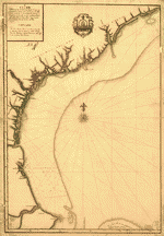
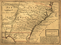
Plano. I descripcion de la costa, desde el Cavo Cañaveral, hasta cerca de la boca de la Vir[g]inia, contando, costa de Florida, Georgia y Carolinas del S, y N, con todos sus puertos, este[ros ... ]letas, baxos, islas y rios; segun las vlti[mas not]icias, hata [sic] oy Octubre de 1756.
| Format |
Map |
|---|---|
| Contributors |
Linares, Juan |
| Dates |
1756 |
| Location |
Atlantic Coast South Atlantic States United States |
| Language |
Castilian Spanish |
| Subjects |
Atlantic Coast Atlantic Coast (U.S.) Coasts South Atlantic States United States |
- Title
- Plano. I descripcion de la costa, desde el Cavo Cañaveral, hasta cerca de la boca de la Vir[g]inia, contando, costa de Florida, Georgia y Carolinas del S, y N, con todos sus puertos, este[ros ... ]letas, baxos, islas y rios; segun las vlti[mas not]icias, hata [sic] oy Octubre de 1756.
- Description
-
Scale ca. 1:1,000,000.
-
Manuscript, ink and watercolor.
-
Depths shown by soundings. Shoals outlined in green.
-
"N.4" and initials of Dn. Badaraco inscribed under title.
-
Imperfect: Parts of title washed away.
-
LC Maps of North America, 1750-1789, 1382
-
LC Luso-Hispanic World, 849
-
Available also through the Library of Congress Web site as a raster image.
-
col. map 73 x 51 cm.
- Creator
- Linares, Juan.
- Created Published
-
[1756]
- Subject Headings
-
-
Coasts--South Atlantic States
-
-
Atlantic Coast (U.S.)
-
-
United States--South Atlantic States.
-
-
United States--Atlantic Coast.
- Notes
-
-
Scale ca. 1:1,000,000.
-
-
Manuscript, ink and watercolor.
-
-
Depths shown by soundings. Shoals outlined in green.
-
-
"N.4" and initials of Dn. Badaraco inscribed under title.
-
-
Imperfect: Parts of title washed away.
-
-
LC Maps of North America, 1750-1789, 1382
-
-
LC Luso-Hispanic World, 849
-
-
Available also through the Library of Congress Web site as a raster image.
- Medium
-
col. map 73 x 51 cm.
- Call Number
-
G3872.C6 1756 .L5
- Repository
-
Library of Congress Geography and Map Division Washington, D.C. 20540-4650 USA dcu
- Digital Id
-
g3872c ct000339 http://hdl.loc.gov/loc.gmd/g3872c.ct000339
- Library of Congress Catalog Number
- 74694107
Rights & Access
The maps in the Map Collections materials were either published prior to 1922, produced by the United States government, or both (see catalogue records that accompany each map for information regarding date of publication and source). The Library of Congress is providing access to these materials for educational and research purposes and is not aware of any U.S. copyright protection (see Title 17 of the United States Code) or any other restrictions in the Map Collection materials.
Note that the written permission of the copyright owners and/or other rights holders (such as publicity and/or privacy rights) is required for distribution, reproduction, or other use of protected items beyond that allowed by fair use or other statutory exemptions. Responsibility for making an independent legal assessment of an item and securing any necessary permissions ultimately rests with persons desiring to use the item.
More about Copyright and other Restrictions
For guidance about compiling full citations consult Citing Primary Sources.
Part of...
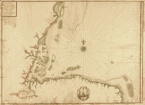
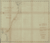
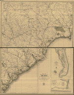
More maps like this
-
 Plano de Costa Rica /
Contributor:
Linares, Juan
Site:
American Memory-cultural, Main Catalog
Original Format:
Map
Date:
1758
View catalog record
Plano de Costa Rica /
Contributor:
Linares, Juan
Site:
American Memory-cultural, Main Catalog
Original Format:
Map
Date:
1758
View catalog record
-
 Plano de la costa de Honduras desde el Cavo de Gracias a Dios hasta el de Catoche, corregido pr. diferentes pilotos, año de 1756 /
Contributor:
Linares, Juan
Site:
American Memory-cultural, Main Catalog
Original Format:
Map
Date:
1756
View catalog record
Plano de la costa de Honduras desde el Cavo de Gracias a Dios hasta el de Catoche, corregido pr. diferentes pilotos, año de 1756 /
Contributor:
Linares, Juan
Site:
American Memory-cultural, Main Catalog
Original Format:
Map
Date:
1756
View catalog record
-
 Plano del puerto de Sta. Marta situado en la costa de Tierra Firme en 11 grs. 16 ms. de latitud N. y en la longitud ...
Contributor:
Linares, Juan
Site:
American Memory-cultural, Main Catalog
Original Format:
Map
Date:
1755
View catalog record
Plano del puerto de Sta. Marta situado en la costa de Tierra Firme en 11 grs. 16 ms. de latitud N. y en la longitud ...
Contributor:
Linares, Juan
Site:
American Memory-cultural, Main Catalog
Original Format:
Map
Date:
1755
View catalog record
-
 Plano del puerto del Guárico, cuyo conocimto. y entrada es del modo siguiente.
Contributor:
Linares, Juan
Site:
American Memory-cultural, Main Catalog
Original Format:
Map
Date:
1756
View catalog record
Plano del puerto del Guárico, cuyo conocimto. y entrada es del modo siguiente.
Contributor:
Linares, Juan
Site:
American Memory-cultural, Main Catalog
Original Format:
Map
Date:
1756
View catalog record
-
 Preliminary chart of the Atlantic coast from Cape Hateras to Cape Florida. Autographic transfer 1861.
Contributor:
United States Coast Survey
Site:
American Memory-cultural, Main Catalog
Original Format:
Map
Date:
1861
View catalog record
Preliminary chart of the Atlantic coast from Cape Hateras to Cape Florida. Autographic transfer 1861.
Contributor:
United States Coast Survey
Site:
American Memory-cultural, Main Catalog
Original Format:
Map
Date:
1861
View catalog record
-
 The coast of the United States : sheet no. 2 from Cape Lookout to Cape Carnaveral [i.e. Canaveral] from the U.S. Coast Surveys.
Contributor:
E. & G.W. Blunt (Firm)
Site:
American Memory-cultural, Main Catalog
Original Format:
Map
Date:
1865
View catalog record
The coast of the United States : sheet no. 2 from Cape Lookout to Cape Carnaveral [i.e. Canaveral] from the U.S. Coast Surveys.
Contributor:
E. & G.W. Blunt (Firm)
Site:
American Memory-cultural, Main Catalog
Original Format:
Map
Date:
1865
View catalog record
-
 Sketch of the Atlantic and Gulf Coasts of the United States showing the loyal part, and the parts of the coasts of the rebellious states ...
Contributor:
Blunt, Edmund
Site:
American Memory-cultural, Main Catalog
Original Format:
Map
Date:
1862
View catalog record
Sketch of the Atlantic and Gulf Coasts of the United States showing the loyal part, and the parts of the coasts of the rebellious states ...
Contributor:
Blunt, Edmund
Site:
American Memory-cultural, Main Catalog
Original Format:
Map
Date:
1862
View catalog record
-
 Descripcion de la costa de Tierra Firme desde el Rio de la Empalizada hasta Cavo de Clara. Por las latitudes y longitudes de Dn. Bartolome ...
Contributor:
Cierto, Balentin
Site:
American Memory-cultural, Main Catalog
Original Format:
Map
Date:
1757
View catalog record
Descripcion de la costa de Tierra Firme desde el Rio de la Empalizada hasta Cavo de Clara. Por las latitudes y longitudes de Dn. Bartolome ...
Contributor:
Cierto, Balentin
Site:
American Memory-cultural, Main Catalog
Original Format:
Map
Date:
1757
View catalog record
-
 General chart of the coast. No. IV, from Cape May to Cape Henry. From a trigonometrical survey under the direction of F. R. Hassler and ...
Contributor:
United States Coast Survey
Site:
American Memory-cultural, Main Catalog
Original Format:
Map
Date:
1862
View catalog record
General chart of the coast. No. IV, from Cape May to Cape Henry. From a trigonometrical survey under the direction of F. R. Hassler and ...
Contributor:
United States Coast Survey
Site:
American Memory-cultural, Main Catalog
Original Format:
Map
Date:
1862
View catalog record
-
 The North-American pilot for New England, New York, Pensilvania, Maryland, and Virginia; also, the two Carolinas, and Florida.
Site:
American Memory-cultural, Main Catalog
Original Format:
Map
Date:
1777
View catalog record
The North-American pilot for New England, New York, Pensilvania, Maryland, and Virginia; also, the two Carolinas, and Florida.
Site:
American Memory-cultural, Main Catalog
Original Format:
Map
Date:
1777
View catalog record
-
 A new map of the country of Carolina.
Contributor:
Gascoyne, Joel
Site:
American Memory-cultural, Main Catalog
Original Format:
Map
Date:
1682
View catalog record
A new map of the country of Carolina.
Contributor:
Gascoyne, Joel
Site:
American Memory-cultural, Main Catalog
Original Format:
Map
Date:
1682
View catalog record
-
 Part of the military department of the South, embracing portions of Georgia and South Carolina, and part of the military department of North Carolina.
Contributor:
United States. Army. Corps of Engineers
Site:
American Memory-cultural, Main Catalog
Original Format:
Map
Date:
1865
View catalog record
Part of the military department of the South, embracing portions of Georgia and South Carolina, and part of the military department of North Carolina.
Contributor:
United States. Army. Corps of Engineers
Site:
American Memory-cultural, Main Catalog
Original Format:
Map
Date:
1865
View catalog record
-
 Carolina.
Contributor:
Moll, Herman
Site:
American Memory-cultural, Main Catalog
Original Format:
Map
Date:
1732
View catalog record
Carolina.
Contributor:
Moll, Herman
Site:
American Memory-cultural, Main Catalog
Original Format:
Map
Date:
1732
View catalog record
-
 Part of the military department of the South, embracing portions of Georgia and South Carolina.
Contributor:
United States. Army. Corps of Engineers
Site:
American Memory-cultural, Main Catalog
Original Format:
Map
Date:
1865
View catalog record
Part of the military department of the South, embracing portions of Georgia and South Carolina.
Contributor:
United States. Army. Corps of Engineers
Site:
American Memory-cultural, Main Catalog
Original Format:
Map
Date:
1865
View catalog record
-
 Monitor map, showing the whole seacoast from Chesapeake Bay, down to Savannah harbor, and the whole country between Richmond & Savannah, with map on large ...
Contributor:
Louis Prang and Company
Site:
American Memory-cultural, Main Catalog
Original Format:
Map
Date:
1863
View catalog record
Monitor map, showing the whole seacoast from Chesapeake Bay, down to Savannah harbor, and the whole country between Richmond & Savannah, with map on large ...
Contributor:
Louis Prang and Company
Site:
American Memory-cultural, Main Catalog
Original Format:
Map
Date:
1863
View catalog record
-
 Map showing route of marches of the army of Genl. W. T. Sherman from Atlanta, Ga., to Goldsboro, N.C. : to accompany the report of ...
Contributor:
United States. Army. Corps of Engineers
Site:
American Memory-cultural, Main Catalog
Original Format:
Map
Date:
1865
View catalog record
Map showing route of marches of the army of Genl. W. T. Sherman from Atlanta, Ga., to Goldsboro, N.C. : to accompany the report of ...
Contributor:
United States. Army. Corps of Engineers
Site:
American Memory-cultural, Main Catalog
Original Format:
Map
Date:
1865
View catalog record
You might also like
-

 The summer tourist's pocket guide to American watering-places : with map and tables of distances /
Contributor:
Hall, Edward H.
Site:
Main Catalog
Original Format:
Book
Date:
1869
The summer tourist's pocket guide to American watering-places : with map and tables of distances /
Contributor:
Hall, Edward H.
Site:
Main Catalog
Original Format:
Book
Date:
1869
-
A summer note-book ...
Contributor:
Bramhall, Frank J.
Site:
Main Catalog
Original Format:
Book
Date:
1895
-
Our summer retreats. A handbook to all the chief waterfalls, springs . . . and other places of interest in the United States . . ...
Site:
Main Catalog
Original Format:
Book
Date:
1858
-
The siege of Charleston and the operations on the south Atlantic coast in the war amoung the states,
Contributor:
Jones, Samuel
Site:
Main Catalog
Original Format:
Book
Date:
1911
-
H.R. 3331, the Atlantic Highly Migratory Species Conservation Act; H.R. 3390, the Atlantic Highly Migratory Species Conservation Act; H.R. 3516, to prohibit pelagic longline fishing ...
Contributor:
United States. Congress. House. Committee on Resources. Subcommittee on Fisheries Conservation, Wildlife, and Oceans
Site:
Main Catalog
Original Format:
Book
Date:
2000-02-08
-