Map
America Septentrionalis a Domino d'Anville in Galliis edita nunc in Anglia. Coloniis in interiorem Virginiam deductis nec non Fluvii Ohio cursu aucta notisque geographicis et historicis illustrata.

| Format |
Map |
|---|---|
| Contributors |
Homann Erben (Firm) |
| Dates |
1756 |
| Location |
North America |
| Language |
Latin |
| Subjects |
North America |
- Title
- America Septentrionalis a Domino d'Anville in Galliis edita nunc in Anglia. Coloniis in interiorem Virginiam deductis nec non Fluvii Ohio cursu aucta notisque geographicis et historicis illustrata.
- Description
-
Scale ca. 1:6,500,000.
-
Hand colored.
-
Relief shown pictorially.
-
Prime meridian: Ferro and London.
-
Place names and descriptive notes in English.
-
Differs from other copies in coloration and boundaries.
-
Colors do not agree with legend. Boundary of Georgia extends from St. John's River up "Altamaha" River to and along the lowest tributary shown, north to the mountains, east to "Keeowee," and southeast to Savannah.
-
Engraving in cartouche differs slightly from other copies.
-
LC Maps of North America, 1750-1789, 68
-
Available also through the Library of Congress Web site as a raster image.
-
Includes German text relating to English and French territorial claims.
-
col. map 46 x 51 cm.
- Creator
- Homann Erben (Firm)
- Created Published
-
Noribergæ, 1756.
- Subject Headings
-
-
North America
-
-
North America.
- Notes
-
-
Scale ca. 1:6,500,000.
-
-
Hand colored.
-
-
Relief shown pictorially.
-
-
Prime meridian: Ferro and London.
-
-
Place names and descriptive notes in English.
-
-
Differs from other copies in coloration and boundaries.
-
-
Colors do not agree with legend. Boundary of Georgia extends from St. John's River up "Altamaha" River to and along the lowest tributary shown, north to the mountains, east to "Keeowee," and southeast to Savannah.
-
-
Engraving in cartouche differs slightly from other copies.
-
-
LC Maps of North America, 1750-1789, 68
-
-
Available also through the Library of Congress Web site as a raster image.
-
-
Includes German text relating to English and French territorial claims.
- Medium
-
col. map 46 x 51 cm.
- Call Number
-
G3300 1756 .H62
- Repository
-
Library of Congress Geography and Map Division Washington, D.C. 20540-4650 USA dcu
- Digital Id
-
g3300 ar006802 http://hdl.loc.gov/loc.gmd/g3300.ar006802
- Library of Congress Catalog Number
- 75693500
Rights & Access
The maps in the Map Collections materials were either published prior to 1922, produced by the United States government, or both (see catalogue records that accompany each map for information regarding date of publication and source). The Library of Congress is providing access to these materials for educational and research purposes and is not aware of any U.S. copyright protection (see Title 17 of the United States Code) or any other restrictions in the Map Collection materials.
Note that the written permission of the copyright owners and/or other rights holders (such as publicity and/or privacy rights) is required for distribution, reproduction, or other use of protected items beyond that allowed by fair use or other statutory exemptions. Responsibility for making an independent legal assessment of an item and securing any necessary permissions ultimately rests with persons desiring to use the item.
More about Copyright and other Restrictions
For guidance about compiling full citations consult Citing Primary Sources.
Part of...
More maps like this
-
 America Septentrionalis a Domino d'Anville in Galliis edita nunc in Anglia. Coloniis in interiorem Virginiam deductis nec non Fluvii Ohio cursu aucta notisque geographicis et ...
Contributor:
Homann Erben (Firm)
Site:
American Memory-cultural, Main Catalog
Original Format:
Map
Date:
1756
View catalog record
America Septentrionalis a Domino d'Anville in Galliis edita nunc in Anglia. Coloniis in interiorem Virginiam deductis nec non Fluvii Ohio cursu aucta notisque geographicis et ...
Contributor:
Homann Erben (Firm)
Site:
American Memory-cultural, Main Catalog
Original Format:
Map
Date:
1756
View catalog record
-
 America Septentrionalis a Domini d'Anville in Galliis edita nunc in Anglia. Coloniis in interiorem Virginiam deductis nec non Fluvii Ohio cursu aucta notisque geographicis et ...
Contributor:
Homann Erben (Firm)
Site:
American Memory-cultural, Main Catalog
Original Format:
Map
Date:
1756
View catalog record
America Septentrionalis a Domini d'Anville in Galliis edita nunc in Anglia. Coloniis in interiorem Virginiam deductis nec non Fluvii Ohio cursu aucta notisque geographicis et ...
Contributor:
Homann Erben (Firm)
Site:
American Memory-cultural, Main Catalog
Original Format:
Map
Date:
1756
View catalog record
-
 America Septentrionalis a Domini d'Anville in Galliis edita nunc in Anglia. Coloniis in interiorem Virginiam deductis nec non Fluvii Ohio aucta cursu notisque geographicis et ...
Contributor:
Homann Erben (Firm)
Site:
American Memory-cultural, Main Catalog
Original Format:
Map
Date:
1763
View catalog record
America Septentrionalis a Domini d'Anville in Galliis edita nunc in Anglia. Coloniis in interiorem Virginiam deductis nec non Fluvii Ohio aucta cursu notisque geographicis et ...
Contributor:
Homann Erben (Firm)
Site:
American Memory-cultural, Main Catalog
Original Format:
Map
Date:
1763
View catalog record
-
 America Septentrionalis a Domini d'Anville in Galliis edita nunc in Anglia. Coloniis in interiorem Virginiam deductis nec non Fluvii Ohio cursu aucta notisque geographicis et ...
Contributor:
Homann Erben (Firm)
Site:
American Memory-cultural, Main Catalog
Original Format:
Map
Date:
1756
View catalog record
America Septentrionalis a Domini d'Anville in Galliis edita nunc in Anglia. Coloniis in interiorem Virginiam deductis nec non Fluvii Ohio cursu aucta notisque geographicis et ...
Contributor:
Homann Erben (Firm)
Site:
American Memory-cultural, Main Catalog
Original Format:
Map
Date:
1756
View catalog record
-
 America Septentrionalis a Domino d'Anville in Galliis edita nunc in Anglia. Coloniis in interiorem Virginiam deductis nec non Fluvii Ohio cursu aucta notisque geographicis et ...
Contributor:
Homann Erben (Firm)
Site:
American Memory-cultural, Main Catalog
Original Format:
Map
Date:
1777
View catalog record
America Septentrionalis a Domino d'Anville in Galliis edita nunc in Anglia. Coloniis in interiorem Virginiam deductis nec non Fluvii Ohio cursu aucta notisque geographicis et ...
Contributor:
Homann Erben (Firm)
Site:
American Memory-cultural, Main Catalog
Original Format:
Map
Date:
1777
View catalog record
-
 Dominia Anglorum in America Septentrionali.
Contributor:
Homann Erben (Firm)
Site:
American Memory-cultural, Main Catalog
Original Format:
Map
Date:
1759
View catalog record
Dominia Anglorum in America Septentrionali.
Contributor:
Homann Erben (Firm)
Site:
American Memory-cultural, Main Catalog
Original Format:
Map
Date:
1759
View catalog record
-
 Accurater Grundris und Prospect der weltberuhmten Hollandischen Haupt und Handels-Stadt Amsterdam /
Contributor:
Homann Erben (Firm)
Site:
American Memory-cultural, Main Catalog
Original Format:
Map
Date:
1727
View catalog record
Accurater Grundris und Prospect der weltberuhmten Hollandischen Haupt und Handels-Stadt Amsterdam /
Contributor:
Homann Erben (Firm)
Site:
American Memory-cultural, Main Catalog
Original Format:
Map
Date:
1727
View catalog record
-
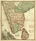 Peninsula Indiæ citra Gangem hoc est Orae celeberrimae Malabar & Coromandel cum adjacente insula non minus celebratissima Ceylon.
Contributor:
Homann Erben (Firm)
Site:
American Memory-cultural, Main Catalog
Original Format:
Map
Date:
1733
View catalog record
Peninsula Indiæ citra Gangem hoc est Orae celeberrimae Malabar & Coromandel cum adjacente insula non minus celebratissima Ceylon.
Contributor:
Homann Erben (Firm)
Site:
American Memory-cultural, Main Catalog
Original Format:
Map
Date:
1733
View catalog record
-
 B. New Engelland, New York, New Yersey und Pensilvania.
Contributor:
Homann Erben (Firm)
Site:
American Memory-cultural, Main Catalog
Original Format:
Map
Date:
1759
View catalog record
B. New Engelland, New York, New Yersey und Pensilvania.
Contributor:
Homann Erben (Firm)
Site:
American Memory-cultural, Main Catalog
Original Format:
Map
Date:
1759
View catalog record
-
 Mappa geographica Provinciæ Nova Eboraci ab Anglis New-York dictæ ex ampliori delineatione ad exactas dimensiones concinnata in arctius spatium redacta cura Claudii Josephi Sauthier cui ...
Contributor:
Homann Erben (Firm)
Site:
American Memory-cultural, Main Catalog
Original Format:
Map
Date:
1778
View catalog record
Mappa geographica Provinciæ Nova Eboraci ab Anglis New-York dictæ ex ampliori delineatione ad exactas dimensiones concinnata in arctius spatium redacta cura Claudii Josephi Sauthier cui ...
Contributor:
Homann Erben (Firm)
Site:
American Memory-cultural, Main Catalog
Original Format:
Map
Date:
1778
View catalog record
-
 Dominia anglorum in præcipuis insulis Americæ ut sunt insula: S. Christophori, Antegoa, Iamaica, Barbados; nec non insulae Bermudes vel Sommers dictae, singulari mappa omnia exhibita ...
Contributor:
Homann Erben (Firm)
Site:
American Memory-cultural, Main Catalog
Original Format:
Map
Date:
1759
View catalog record
Dominia anglorum in præcipuis insulis Americæ ut sunt insula: S. Christophori, Antegoa, Iamaica, Barbados; nec non insulae Bermudes vel Sommers dictae, singulari mappa omnia exhibita ...
Contributor:
Homann Erben (Firm)
Site:
American Memory-cultural, Main Catalog
Original Format:
Map
Date:
1759
View catalog record
-
 Gvinea propia, nec non Nigritiæ vel Terræ Nigrorvm maxima pars : geographis hodiernis dicta utraq[ue] Æthiopia inferior, & hujus quidem pars australis /
Contributor:
Homann Erben (Firm)
Site:
American Memory-cultural, Main Catalog
Original Format:
Map
Date:
1743
View catalog record
Gvinea propia, nec non Nigritiæ vel Terræ Nigrorvm maxima pars : geographis hodiernis dicta utraq[ue] Æthiopia inferior, & hujus quidem pars australis /
Contributor:
Homann Erben (Firm)
Site:
American Memory-cultural, Main Catalog
Original Format:
Map
Date:
1743
View catalog record
-
 Dominia anglorum in præcipuis insulis Americæ ut sunt insula: Christophori, Antegoa, Iamaica, Barbados; nec non insulae Bermudes vel Sommers dictae, singulari mappa omnia a exhibita ...
Contributor:
Homann Erben (Firm)
Site:
American Memory-cultural, Main Catalog
Original Format:
Map
Date:
1759
View catalog record
Dominia anglorum in præcipuis insulis Americæ ut sunt insula: Christophori, Antegoa, Iamaica, Barbados; nec non insulae Bermudes vel Sommers dictae, singulari mappa omnia a exhibita ...
Contributor:
Homann Erben (Firm)
Site:
American Memory-cultural, Main Catalog
Original Format:
Map
Date:
1759
View catalog record
-

 Carte des anomalies magnétiques de l'Amérique du Nord = Magnetic anomaly map of North America /
Contributor:
North American Magnetic Anomaly Group
Site:
Main Catalog
Original Format:
Map
Date:
2002
Carte des anomalies magnétiques de l'Amérique du Nord = Magnetic anomaly map of North America /
Contributor:
North American Magnetic Anomaly Group
Site:
Main Catalog
Original Format:
Map
Date:
2002
You might also like
-
 Monography of the family Unionidæ,
Contributor:
Conrad, T. A.
Site:
Main Catalog
Original Format:
Book
Date:
1836
Monography of the family Unionidæ,
Contributor:
Conrad, T. A.
Site:
Main Catalog
Original Format:
Book
Date:
1836
-
The discovery and exploration of America; a book for American boys and girls,
Contributor:
Gilman, Arthur
Site:
Main Catalog
Original Format:
Book
Date:
1887
-
North American shore birds; a history of the snipes, sandpipers, plovers and their allies, inhabiting the beaches and marshes of the Atlantic and Pacific coasts, ...
Contributor:
Elliot, Daniel Giraud
Site:
Main Catalog
Original Format:
Book
Date:
1895
-
Natural history of western wild animals and guide for hunters, trappers, and sportsmen;
Contributor:
Cartwright, David W.
Site:
Main Catalog
Original Format:
Book
Date:
1875
-
The American salmon fisherman,
Contributor:
Wells, Henry P.
Site:
Main Catalog
Original Format:
Book
Date:
1886
-
A systematic treatise, historical, etiological, and practical, on the principal diseases of the interior valley of North America, as they appear in the Caucasian, African, ...
Contributor:
Drake, Daniel
Site:
Main Catalog
Original Format:
Book
Date:
1854