Map
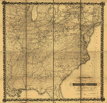
A correct map of a section of the United States showing the allignment [sic] of the Pittsburgh, Marion, and Chicago Railway between Chewton, Penna. and Marion, Ohio and connections.

| Format |
Map |
|---|---|
| Contributors |
G.W. & C.B. Colton & Co |
| Dates |
1887 |
| Location |
Northeastern States United States |
| Language |
English |
| Subjects |
Coal Mines And Mining Northeastern States Pittsburgh, Marion, And Chicago Railway Railroads United States |
- Title
- A correct map of a section of the United States showing the allignment [sic] of the Pittsburgh, Marion, and Chicago Railway between Chewton, Penna. and Marion, Ohio and connections.
- Description
-
Scale 1:1,267,200.
-
LC Railroad maps, 535
-
Description derived from published bibliography.
-
Map of parts of Pennsylvania and Ohio showing drainage, cities and towns, township and county boundaries, and coal fields. Railroad network distinguished by color.
-
Available also through the Library of Congress Web site as a raster image.
-
col. map 44 x 97 cm.
- Creator
- G.W. & C.B. Colton & Co.
- Created Published
-
New York, 1887.
- Subject Headings
-
-
Pittsburgh, Marion, and Chicago Railway.
-
-
Railroads--Northeastern States
-
-
Coal mines and mining--Northeastern States
-
-
United States--Northeastern States.
- Notes
-
-
Scale 1:1,267,200.
-
-
LC Railroad maps, 535
-
-
Description derived from published bibliography.
-
-
Map of parts of Pennsylvania and Ohio showing drainage, cities and towns, township and county boundaries, and coal fields. Railroad network distinguished by color.
-
-
Available also through the Library of Congress Web site as a raster image.
- Medium
-
col. map 44 x 97 cm.
- Call Number
-
G3711.P3 1887 .G15
- Repository
-
Library of Congress Geography and Map Division Washington, D.C. 20540-4650 USA dcu
- Digital Id
-
g3711p rr005350 http://hdl.loc.gov/loc.gmd/g3711p.rr005350
- Library of Congress Catalog Number
- 98688780
Rights & Access
The maps in the Map Collections materials were either published prior to 1922, produced by the United States government, or both (see catalogue records that accompany each map for information regarding date of publication and source). The Library of Congress is providing access to these materials for educational and research purposes and is not aware of any U.S. copyright protection (see Title 17 of the United States Code) or any other restrictions in the Map Collection materials.
Note that the written permission of the copyright owners and/or other rights holders (such as publicity and/or privacy rights) is required for distribution, reproduction, or other use of protected items beyond that allowed by fair use or other statutory exemptions. Responsibility for making an independent legal assessment of an item and securing any necessary permissions ultimately rests with persons desiring to use the item.
More about Copyright and other Restrictions
For guidance about compiling full citations consult Citing Primary Sources.
Part of...
-
Railroad Maps, 1828 1900
[617]
-
Transportation And Communication Cartographic Items
[761]
-
Geography And Maps Division
[60803]
-
American Memory
[1121009]
More maps like this
-
 Railroad & express map of the middle states.
Contributor:
G.W. & C.B. Colton & Co
Site:
American Memory-cultural, Main Catalog
Original Format:
Map
Date:
1867
View catalog record
Railroad & express map of the middle states.
Contributor:
G.W. & C.B. Colton & Co
Site:
American Memory-cultural, Main Catalog
Original Format:
Map
Date:
1867
View catalog record
-
 Map of the Erie Railway and its connections.
Contributor:
G.W. & C.B. Colton & Co
Site:
American Memory-cultural, Main Catalog
Original Format:
Map
Date:
1869
View catalog record
Map of the Erie Railway and its connections.
Contributor:
G.W. & C.B. Colton & Co
Site:
American Memory-cultural, Main Catalog
Original Format:
Map
Date:
1869
View catalog record
-
 Map showing the route of the Chicago and Canada Southern Railway and its connecting lines.
Contributor:
G.W. & C.B. Colton & Co
Site:
American Memory-cultural, Main Catalog
Original Format:
Map
Date:
1872
View catalog record
Map showing the route of the Chicago and Canada Southern Railway and its connecting lines.
Contributor:
G.W. & C.B. Colton & Co
Site:
American Memory-cultural, Main Catalog
Original Format:
Map
Date:
1872
View catalog record
-
 Map of the Marietta and Pittsburgh Railroad and its connections.
Contributor:
G.W. & C.B. Colton & Co
Site:
American Memory-cultural, Main Catalog
Original Format:
Map
Date:
1871
View catalog record
Map of the Marietta and Pittsburgh Railroad and its connections.
Contributor:
G.W. & C.B. Colton & Co
Site:
American Memory-cultural, Main Catalog
Original Format:
Map
Date:
1871
View catalog record
-
 Map showing the location of the Flat-Top Coal Field and present and proposed railroads.
Contributor:
G.W. & C.B. Colton & Co
Site:
American Memory-cultural, Main Catalog
Original Format:
Map
Date:
1889
View catalog record
Map showing the location of the Flat-Top Coal Field and present and proposed railroads.
Contributor:
G.W. & C.B. Colton & Co
Site:
American Memory-cultural, Main Catalog
Original Format:
Map
Date:
1889
View catalog record
-
 Map showing the line of the Louisville, New Albany, and St. Louis Air Line Railroad and its connections.
Contributor:
G.W. & C.B. Colton & Co
Site:
American Memory-cultural, Main Catalog
Original Format:
Map
Date:
1872
View catalog record
Map showing the line of the Louisville, New Albany, and St. Louis Air Line Railroad and its connections.
Contributor:
G.W. & C.B. Colton & Co
Site:
American Memory-cultural, Main Catalog
Original Format:
Map
Date:
1872
View catalog record
-
 Maps showing the connections of the Northern and Southern West Virginia Railroad, with the three grand trunk railways which unite the Atlantic seaboard with the ...
Contributor:
G.W. & C.B. Colton & Co
Site:
American Memory-cultural, Main Catalog
Original Format:
Map
Date:
1873
View catalog record
Maps showing the connections of the Northern and Southern West Virginia Railroad, with the three grand trunk railways which unite the Atlantic seaboard with the ...
Contributor:
G.W. & C.B. Colton & Co
Site:
American Memory-cultural, Main Catalog
Original Format:
Map
Date:
1873
View catalog record
-
 Railroad map showing the lands of the Standard Coal and Iron Co. situated in the Hocking Valley, Ohio, and their relation to the markets of ...
Contributor:
G.W. & C.B. Colton & Co
Site:
American Memory-cultural, Main Catalog
Original Format:
Map
Date:
1881
View catalog record
Railroad map showing the lands of the Standard Coal and Iron Co. situated in the Hocking Valley, Ohio, and their relation to the markets of ...
Contributor:
G.W. & C.B. Colton & Co
Site:
American Memory-cultural, Main Catalog
Original Format:
Map
Date:
1881
View catalog record
-
 Map showing the Sodus Point & Southern Railroad and its connections.
Contributor:
G.W. & C.B. Colton & Co
Site:
American Memory-cultural, Main Catalog
Original Format:
Map
Date:
1872
View catalog record
Map showing the Sodus Point & Southern Railroad and its connections.
Contributor:
G.W. & C.B. Colton & Co
Site:
American Memory-cultural, Main Catalog
Original Format:
Map
Date:
1872
View catalog record
-
 Maps showing the Toledo, Cincinnati, & St. Louis Railroad and its connections, 1881.
Contributor:
G.W. & C.B. Colton & Co
Site:
American Memory-cultural, Main Catalog
Original Format:
Map
Date:
1881
View catalog record
Maps showing the Toledo, Cincinnati, & St. Louis Railroad and its connections, 1881.
Contributor:
G.W. & C.B. Colton & Co
Site:
American Memory-cultural, Main Catalog
Original Format:
Map
Date:
1881
View catalog record
-
 Map showing the road of the Coal and Iron Railway Co. and the coal and iron ore lands along its line.
Contributor:
G.W. & C.B. Colton & Co
Site:
American Memory-cultural, Main Catalog
Original Format:
Map
Date:
1882
View catalog record
Map showing the road of the Coal and Iron Railway Co. and the coal and iron ore lands along its line.
Contributor:
G.W. & C.B. Colton & Co
Site:
American Memory-cultural, Main Catalog
Original Format:
Map
Date:
1882
View catalog record
-
 Map showing the Seaboard, Pennsylvania and Western Railroad and its connections.
Contributor:
G.W. & C.B. Colton & Co
Site:
American Memory-cultural, Main Catalog
Original Format:
Map
Date:
1884
View catalog record
Map showing the Seaboard, Pennsylvania and Western Railroad and its connections.
Contributor:
G.W. & C.B. Colton & Co
Site:
American Memory-cultural, Main Catalog
Original Format:
Map
Date:
1884
View catalog record
-
 Map showing the projected route of the Potomac and Ohio Railway.
Contributor:
G.W. & C.B. Colton & Co
Site:
American Memory-cultural, Main Catalog
Original Format:
Map
Date:
1874
View catalog record
Map showing the projected route of the Potomac and Ohio Railway.
Contributor:
G.W. & C.B. Colton & Co
Site:
American Memory-cultural, Main Catalog
Original Format:
Map
Date:
1874
View catalog record
-
 New railway map of the United States.
Contributor:
G.W. & C.B. Colton & Co
Site:
American Memory-cultural, Main Catalog
Original Format:
Map
Date:
1867
View catalog record
New railway map of the United States.
Contributor:
G.W. & C.B. Colton & Co
Site:
American Memory-cultural, Main Catalog
Original Format:
Map
Date:
1867
View catalog record
-
 Colton's intermediate railroad map of the United States.
Contributor:
G.W. & C.B. Colton & Co
Site:
American Memory-cultural, Main Catalog
Original Format:
Map
Date:
1882
View catalog record
Colton's intermediate railroad map of the United States.
Contributor:
G.W. & C.B. Colton & Co
Site:
American Memory-cultural, Main Catalog
Original Format:
Map
Date:
1882
View catalog record
-
 Colton's railroad map (intermediate size) of the United States reduced from "Colton's railroad and commercial map of the United States."
Contributor:
G.W. & C.B. Colton & Co
Site:
American Memory-cultural, Main Catalog
Original Format:
Map
Date:
1870
View catalog record
Colton's railroad map (intermediate size) of the United States reduced from "Colton's railroad and commercial map of the United States."
Contributor:
G.W. & C.B. Colton & Co
Site:
American Memory-cultural, Main Catalog
Original Format:
Map
Date:
1870
View catalog record
You might also like
-
 H.R.15498 - Rural Rail Preservation and Improvement Act
Contributor:
Thone, Charles
Site:
Thomas-legislative
Original Format:
Legislation
Date:
1974-06-19
H.R.15498 - Rural Rail Preservation and Improvement Act
Contributor:
Thone, Charles
Site:
Thomas-legislative
Original Format:
Legislation
Date:
1974-06-19
-
S.1216 - North Eastern Rail Service Preservation Act
Contributor:
Saxbe, William B.
Site:
Thomas-legislative
Original Format:
Legislation
Date:
1973-03-14
-
S.2060 - Emergency Rail Services Act Amendments
Contributor:
Hartke, Vance
Site:
Thomas-legislative
Original Format:
Legislation
Date:
1973-06-25
-
S.3438 - Rural Rail Preservation and Improvement Act
Contributor:
Mondale, Walter F.
Site:
Thomas-legislative
Original Format:
Legislation
Date:
1974-05-02
-
S.3569 - Amtrak Improvement Act
Contributor:
Hartke, Vance
Site:
Thomas-legislative
Original Format:
Legislation
Date:
1974-06-03
-
H.R.15194 - A bill to require the Secretary of Transportation to investigate and report to the Congress with respect to whether certain railroad facilities and ...
Contributor:
Carey, Hugh L.
Site:
Thomas-legislative
Original Format:
Legislation
Date:
1974-06-05