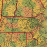
![[Base map of Pennsylvania].](https://cybercemetery.unt.edu/archive/oilspill/20130108030322im_/http://www.loc.gov/collections/static/hotchkiss-maps/images/cwh00207.jpg)

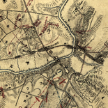
![[Detailed map of part of Virginia from Alexandria to the Potomac River above Washington, D.C. 1886].](https://cybercemetery.unt.edu/archive/oilspill/20130108030322im_/http://www.loc.gov/collections/static/civil-war-maps/images/cw0523000.jpg)
![[January 18, 1945], HQ Twelfth Army Group situation map.](https://cybercemetery.unt.edu/archive/oilspill/20130108030322im_/http://www.loc.gov/collections/static/world-war-ii-maps-military-situation-maps-from-1944-to-1945/images/ict21228.jpg)
![[Rough sketch of the Rich Mountain battle area extending from Beverly, W. Va. to Clarksburg].](https://cybercemetery.unt.edu/archive/oilspill/20130108030322im_/http://www.loc.gov/collections/static/hotchkiss-maps/images/cwh00078.jpg)


![[Sketch of the battles of Chancellorsville, Salem Church, and Fredericksburg], May 2, 3, and 4, 1863](https://cybercemetery.unt.edu/archive/oilspill/20130108030322im_/http://www.loc.gov/collections/static/civil-war-maps/images/cwh00129.jpg)
![Map of the Rappahannock River from [sic] Port Royal to Richards Ferry](https://cybercemetery.unt.edu/archive/oilspill/20130108030322im_/http://www.loc.gov/collections/static/civil-war-maps/images/cw0619600.jpg)
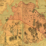
![Plano. I descripcion de la costa, desde el Cavo Cañaveral, hasta cerca de la boca de la Vir[g]inia, contando, costa de Florida, Georgia y Carolinas del S, y N, con todos sus puertos, este[ros ... ]letas, baxos, islas y rios; segun las vlti[mas not]icias, hata [sic] oy Octubre de 1756.](https://cybercemetery.unt.edu/archive/oilspill/20130108030322im_/http://www.loc.gov/collections/static/american-revolutionary-war-maps/images/ct000339.jpg)
Results
-

Ed. H. Radcliffe's (Frankford, Pa.) business map of Bristol, Bordentown, Burlington, and Mount Holly.
General city/borough street maps.
Contributor: Radcliffe, Edward H. Site: American Memory-cultural - Main Catalog Original Format: Map Date: 1870 View catalog record -

Lewisburgh.
Perspective map not drawn to scale.
Contributor: O.H. Bailey & Co Site: American Memory-cultural - Main Catalog Original Format: Map Date: 1884 View catalog record -

Jermyn, Lackawanna County, Pa.
Perspective map not drawn to scale.
Contributor: Fowler, T. M. Site: American Memory-cultural - Main Catalog Original Format: Map Date: 1889 View catalog record -

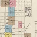
Map of Harrisburg City, Dauphin Co. Pa. /
City street map showing ward boundaries, ward names, and principal buildings.
Contributor: Boyd, William Henry Site: American Memory-cultural - Main Catalog Original Format: Map Date: 1893 View catalog record -

Seat of war in the environs of Philadelphia:
Scale ca. 1:656,000.
Contributor: Kitchin, Thomas Site: American Memory-cultural - Main Catalog Original Format: Map Date: 1777 View catalog record -

The City of New York as laid out by the Commissioners with the surrounding country /
Street planning map. Covers all of Manhattan Island (New York, N.Y.) and substantial parts of adjacent counties in New York and New Jersey. Shows existing and proposed streets; also buildings and other ...
Contributor: Randel, John Site: American Memory-cultural - Main Catalog Original Format: Map Date: 1821 View catalog record -
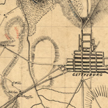
Map of Gettysburg and vicinity /
Shows Civil-War battle positions in rural districts surrounding Gettysburg (Pa.). Union lines are shown by blue dashes and Confederate lines by red ones. Also shows locations of artillery, significant features of the ...
Contributor: Weeks, Gaylord Site: American Memory-cultural - Main Catalog Original Format: Map Date: 1863 View catalog record -

Map of Lawrence and Beaver counties /
LC Land ownership maps, 764
Contributor: Ames, N. S. Site: American Memory-cultural - Main Catalog Original Format: Map Date: 1860 View catalog record -

The battlefield of Gettysburg, July 1st, 2nd and 3rd, 1863
Scale 1:15,840.
Contributor: Minnigh, Luther W. Site: American Memory-cultural - Main Catalog Original Format: Map Date: 1905 View catalog record -

1st. & 2d. position of that part of the army engaged on the 19th Sept. 1777. 3d & 4th postn. Sept. 19.
Scale not given.
Contributor: Wangenheim, Friedrich Adam Julius von Site: American Memory-cultural - Main Catalog Original Format: Map Date: 1777 View catalog record -

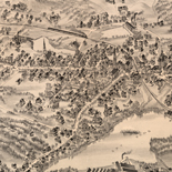
Birds-eye view of the battlefield of Gettysburg.
"Copyright Jan. 18, 1901. C 476 H" in pencil in lower margin. DLC
Contributor: Gettysburg National Military Park Commission Site: American Memory-cultural - Main Catalog Original Format: Map Date: 1901 View catalog record -

Du Bois, Clearfield County, Pennsylvania, 1895.
Perspective map not drawn to scale.
Contributor: Fowler, T. M. Site: American Memory-cultural - Main Catalog Original Format: Map Date: 1895 View catalog record -
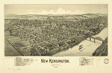
New Kensington, Pennsylvania, 1902.
Perspective map not drawn to scale.
Contributor: Fowler, T. M. Site: American Memory-cultural - Main Catalog Original Format: Map Date: 1902 View catalog record -
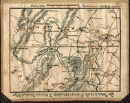
Map showing vicinity of battlefield of Antietam Md.
NOTE: Researchers will be served a color photocopy of this diary image.
Contributor: Sneden, Robert Knox Site: American Memory-cultural Original Format: Map Date: 1862 -

Jeannette, Westmoreland County, Pennsylvania, 1897.
Perspective map not drawn to scale.
Contributor: Fowler, T. M. Site: American Memory-cultural - Main Catalog Original Format: Map Date: 1897 View catalog record -

The battle of Gettysburg. February 1948, revised 1951.
Scale ca. 1:60,000.
Contributor: United States. National Park Service Site: American Memory-cultural - Main Catalog Original Format: Map Date: 1957 View catalog record -

New Castle, Pennsylvania 1896 /
Perspective map not drawn to scale.
Contributor: Fowler, T. M. Site: American Memory-cultural - Main Catalog Original Format: Map Date: 1896 View catalog record -

Topographic view of the city of Reading, Pa. 1881.
Perspective map not drawn to scale.
Contributor: Kendall, J. Hanold Site: American Memory-cultural - Main Catalog Original Format: Map Date: 1881 View catalog record -

Map of Allegheny County, Pennsylvania, 1890 : with adjoining parts of Westmoreland, Washington & Beaver counties.
General-content county map showing roads, railroads, place-names, coal outcrops/mining areas, individual buildings in rural areas, and householders' names in rural areas. Does not show property lines or cadastral data.
Contributor: Krebs, Otto Site: American Memory-cultural - Main Catalog Original Format: Map Date: 1890 View catalog record -

Route of a proposed railroad from Powelton, West Philada. to the Philada; gas works and thence to the river Delaware; surveyed by the engineer of ...
Scale ca. 1:35,000.
Contributor: Kollner, Augustus Site: American Memory-cultural - Main Catalog Original Format: Map Date: 1856 View catalog record
Refine your search
Original Format
- Map
- Web Page [4]