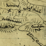
![[Topographical map of part of Washington D.C.].](https://cybercemetery.unt.edu/archive/oilspill/20120921144411im_/http://www.loc.gov/collections/static/civil-war-maps/images/cw0688500.jpg)
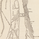
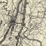
![[Sketch of the battles of Chancellorsville, Salem Church, and Fredericksburg], May 2, 3, and 4, 1863](https://cybercemetery.unt.edu/archive/oilspill/20120921144411im_/http://www.loc.gov/collections/static/civil-war-maps/images/cwh00129.jpg)
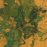
![[Map of Chancellorsville battlefield, May 3-4, 1863].](https://cybercemetery.unt.edu/archive/oilspill/20120921144411im_/http://www.loc.gov/collections/static/hotchkiss-maps/images/cwh00138.jpg)
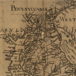
![[Detailed map of part of Virginia from Alexandria to the Potomac River above Washington, D.C. 1886].](https://cybercemetery.unt.edu/archive/oilspill/20120921144411im_/http://www.loc.gov/collections/static/civil-war-maps/images/cw0523000.jpg)
![[January 15, 1945], HQ Twelfth Army Group situation map.](https://cybercemetery.unt.edu/archive/oilspill/20120921144411im_/http://www.loc.gov/collections/static/world-war-II-maps-military-situation-maps-from-1944-to-1945/images/ict21225.jpg)
Results
-

Overview - Maps Of Liberia 1830 To 1870
This collection of Liberia maps includes twenty examples from the American Colonization Society (ACS), organized in 1817 to resettle free black Americans in West Africa. These maps show early settlements in Liberia, ...
Site: LOC.gov web pages - Main Catalog Original Format: Map - Web Page Date: 1998-10-19 View catalog record -

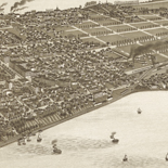
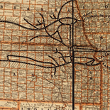
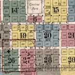
Introduction To The Collection - Sanborn Maps
(This article was published within the Library's publication, Fire Insurance Maps: in the Library of Congress) Key for interpreting Sanborn fire insurance maps The Sanborn map collection consists of a uniform series ...
Site: LOC.gov web pages Original Format: Web Page - Map -

The Battle Of The Bulge - World War Ii Maps Military Situation Maps From 1944 To 1945
A timeline of the Battle of the Bulge told through the daily situation maps made for the US Military VIII Corps. December 16, 1944 - In a quick glance at the situation ...
Site: LOC.gov web pages Original Format: Map - Web Page -

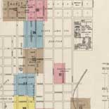
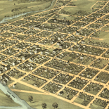
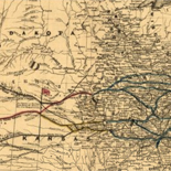
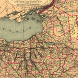
Overview - Railroad Maps 1828 To 1900
The Railroad maps represent an important historical record, illustrating the growth of travel and settlement as well as the development of industry and agriculture in the United States. They depict the development ...
Site: LOC.gov web pages Original Format: Map - Web Page Date: 1998-10-19 -

Overview - Hotchkiss Maps
The Hotchkiss Map Collection contains cartographic items made by Major Jedediah Hotchkiss (1828-1899), a topographic engineer in the Confederate Army. Hotchkiss made detailed battle maps primarily of the Shenandoah Valley, some of ...
Site: LOC.gov web pages - Main Catalog Original Format: Map - Web Page View catalog record -

The Battle Of The Bulge - World War Ii Maps Military Situation Maps From 1944 To 1945
A timeline of the Battle of the Bulge told through the daily situation maps made for the US Military VIII Corps. December 16, 1944 - In a quick glance at the situation ...
Site: LOC.gov web pages Original Format: Map - Web Page -

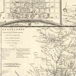
The Exploration And Legacy Of The Louisiana Territory - Louisiana European Explorations And The Louisiana Purchase
American Exploration of Louisiana Acquisition and exploration of American lands throughout the first decade of the 19th century began and ended with President Thomas Jefferson. Whether involved in purchasing the Louisiana Territory; ...
Site: LOC.gov web pages Original Format: Map - Web Page Date: 2007-08-13 -

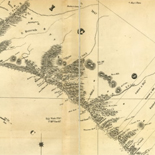
Overview - Discovery And Exploration
This category documents the discovery and exploration with both manuscripts and published maps. Many of these maps reflect the European Age of Discoveries, dating from the late 15th century to the 17th ...
Contributor: Library of Congress Geography and Map Division Site: LOC.gov web pages Original Format: Map - Web Page -
History Of Railroads And Maps - Railroad Maps 1828 To 1900
Railways were introduced in England in the seventeenth century as a way to reduce friction in moving heavily loaded wheeled vehicles. The first North American "gravity road," as it was called, was ...
Site: LOC.gov web pages Original Format: Map - Web Page Date: 1998-10-19 -

Overview - Railroad Maps 1828 To 1900
The Railroad maps represent an important historical record, illustrating the growth of travel and settlement as well as the development of industry and agriculture in the United States. They depict the development ...
Site: LOC.gov web pages Original Format: Map - Web Page Date: 1998-10-19 -
The Cartographic Setting - Louisiana European Explorations And The Louisiana Purchase
Evolving European and American Conceptions of Louisiana to 1803 Until 1803 the exploration and mapping of the territory acquired by the United States in the Louisiana Purchase was undertaken by the major ...
Site: LOC.gov web pages Original Format: Map - Web Page Date: 2007-08-13 -

The Hotchkiss Collection Of Confederate Maps - Hotchkiss Maps
by Clara LeGear Jedediah Hotchkiss was born at Windsor, Broome County, N. Y., November 30, 1828. He was graduated from the Windsor Academy and early showed great interest in botany and in ...
Site: LOC.gov web pages Original Format: Map - Web Page Date: 1948-11-01 -

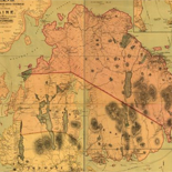
Overview - Civil War Maps
Civil War Maps brings together materials from three premier collections: the Library of Congress Geography and Map Division, the Virginia Historical Society, and the Library of Virginia. Among the reconnaissance, sketch, and ...
Site: LOC.gov web pages - Main Catalog Original Format: Web Page - Map Date: 2008-08-04 View catalog record -

Maps Of Great Smoky Mountains National Park - National Parks Maps
Early European Maps | American Maps and Map Makers | Exploration and Geological Mapping | Environmental Maps | Early USGS Maps | USGS and the TVA -- Topographic Quadrangle Maps | National ...
Site: LOC.gov web pages Original Format: Web Page - Map Date: 1999-06-02 -
Yellowstone The First National Park - National Parks Maps
Among those who played key roles in establishing Yellowstone as the Nation's first national park was Ferdinand Vandiveer Hayden. His accomplishments in 1871-72 were the high point of a long and distinguished ...
Site: LOC.gov web pages Original Format: Map - Web Page Date: 1999-06-02 -

Overview - American Revolutionary War Maps
The American Revolution and Its Era: Maps and Charts of North America and the West Indies, 1750-1789 represents an important historical record of the mapping of North America and the Caribbean. Most ...
Site: LOC.gov web pages - Main Catalog Original Format: Map - Web Page Date: 2008-08-04 View catalog record -

The Exploration And Legacy Of The Louisiana Territory - Louisiana European Explorations And The Louisiana Purchase
American Exploration of Louisiana Acquisition and exploration of American lands throughout the first decade of the 19th century began and ended with President Thomas Jefferson. Whether involved in purchasing the Louisiana Territory; ...
Site: LOC.gov web pages Original Format: Map - Web Page Date: 2007-08-13 -
Sanborn Time Series - Sanborn Maps
Fire insurance maps are valuable to much historic research because they often provide evidence of change over time. Specific changes in an individual site such as when a building was expanded or ...
Site: LOC.gov web pages Original Format: Web Page - Map -

Overview - Rochambeau Maps
The Rochambeau Map Collection contains cartographic items used by Jean Baptiste Donatien de Vimeur, comte de Rochambeau (1725-1807), when he was commander in chief of the French expeditionary army (1780-82) during the ...
Site: LOC.gov web pages - Main Catalog Original Format: Map - Web Page View catalog record -
Louisiana As A French Colony - Louisiana European Explorations And The Louisiana Purchase
Difficult Early Years of the Colony From its inception Louisiana faced an inauspicious existence. Its fate was bound to the French economy during the last years of the reign of Louis XIV. ...
Site: LOC.gov web pages Original Format: Map - Web Page Date: 2007-08-13
Refine your search
Original Format
Online Format
- Web Page
- Image [75]
- PDF [2]
Site
- LOC.gov web pages
- Main Catalog [16]