
| PREVIOUS | NEXT | NEW SEARCH |
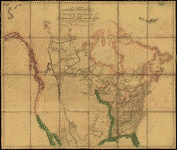
A map exhibiting all the new discoveries in the interior parts of North America / inscribed by permission to the honorable governor and company of adventurers of England trading into Hudsons Bay in testimony of their liberal communications to their most obedient and very humble servant A. Arrowsmith, January 1st 1795.
CREATED/PUBLISHED
Additions to 1802.
London : A. Arrowsmith, [1802]
NOTES
Relief shown by hachures.
Shows "Rivers added east of the Rocky Mountains, 900 L. 450 Lat.," from Tooley's Printed maps of America.
In lower margin: London: Published Jan. 1, 1795 by A. Arrowsmith, No. 24 Rathbone Place.
Includes notes.
Reference: Tooley. Printed maps of America 137
LC copy imperfect: hole in center.
LC copy has label pasted on in upper right margin and annotated in black ink: N. America.
Scale [ca. 1:3,800,000] (W 1600--W 400/N 700--N 250).
SUBJECTS
North America--Maps.
North America.
RELATED NAMES
Puke, J.
MEDIUM
1 map : hand col., mounted on cloth ; 125 x 146 cm., folded to 32 x 25 cm.
CALL NUMBER
G3300 1802 A7 Vault Casetop
REPOSITORY
Library of Congress Geography and Map Division Washington, D.C. 20540-4650 USA
DIGITAL ID
g3300 ct000584 http://hdl.loc.gov/loc.gmd/g3300.ct000584
| PREVIOUS | NEXT | NEW SEARCH |