Map
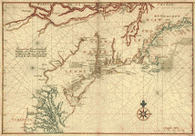
Pascaert van Nieuw Nederlandt Virginia, ende Nieuw-Engelandt verthonendt alles wat van die landin by See, oft by land is ondect oft Bekent.
| Format |
Map |
|---|---|
| Contributors |
Vinckeboons, Joan |
| Dates |
1639 |
| Location |
Atlantic Coast Middle Atlantic States New England North America United States Virginia |
| Language |
Dutch Flemish |
| Subjects |
Atlantic Coast Atlantic Coast (North America) Coasts Middle Atlantic States New England North America United States Virginia |
- Title
- Pascaert van Nieuw Nederlandt Virginia, ende Nieuw-Engelandt verthonendt alles wat van die landin by See, oft by land is ondect oft Bekent.
- Description
-
Shows northeast coast of the United States from New England to Virginia including coastal features and other geographical entities.
-
Pen-and-ink and watercolor.
-
Attributed to Joan Vinckeboons by comparison with his other Dutch maps in Henry Harrisse collection.
-
Described in Terrae incognitae, v. xvi, 1984. Richard W. Stephenson's The Henry Harrisse collection ... , p. 40; the second volume has binder's title "Manuscript maps Atlantic Coast and California drawn by Joan Vingboons in 1639."
-
Available also through the Library of Congress Web site as a raster image.
-
1 ms. map : col., paper backing ; 48 x 69 cm.
- Creator
- Vinckeboons, Joan.
- Created Published
-
[1639?]
- Subject Headings
-
-
Atlantic coast (North America)
-
-
Coasts--New England
-
-
Coasts--Middle Atlantic States
-
-
Coasts--Virginia
-
-
North America--Atlantic coast.
-
-
United States--New England.
-
-
United States--Middle Atlantic States.
-
-
United States--Virginia.
- Notes
-
-
Shows northeast coast of the United States from New England to Virginia including coastal features and other geographical entities.
-
-
Pen-and-ink and watercolor.
-
-
Attributed to Joan Vinckeboons by comparison with his other Dutch maps in Henry Harrisse collection.
-
-
Described in Terrae incognitae, v. xvi, 1984. Richard W. Stephenson's The Henry Harrisse collection ... , p. 40; the second volume has binder's title "Manuscript maps Atlantic Coast and California drawn by Joan Vingboons in 1639."
-
-
Available also through the Library of Congress Web site as a raster image.
- Medium
-
1 ms. map : col., paper backing ; 48 x 69 cm.
- Call Number
-
G3291.S12 coll .H3
- Repository
-
Library of Congress Geography and Map Division Washington, D.C. 20540-4650 USA dcu
- Digital Id
-
g3300 ct001068 http://hdl.loc.gov/loc.gmd/g3300.ct001068
- Library of Congress Catalog Number
- http://memory.loc.gov/cgi-bin/query/r?ammem/AMALL:@field(NUMBER+@band(g3300+ct001068))
Rights & Access
The maps in the Map Collections materials were either published prior to 1922, produced by the United States government, or both (see catalogue records that accompany each map for information regarding date of publication and source). The Library of Congress is providing access to these materials for educational and research purposes and is not aware of any U.S. copyright protection (see Title 17 of the United States Code) or any other restrictions in the Map Collection materials.
Note that the written permission of the copyright owners and/or other rights holders (such as publicity and/or privacy rights) is required for distribution, reproduction, or other use of protected items beyond that allowed by fair use or other statutory exemptions. Responsibility for making an independent legal assessment of an item and securing any necessary permissions ultimately rests with persons desiring to use the item.
More about Copyright and other Restrictions
For guidance about compiling full citations consult Citing Primary Sources.
Part of...
-
General Maps
[2477]
-
Geography And Maps Division
[60803]
-
American Memory
[1121009]
More maps like this
-
 Pascaert van Nieuw Nederlandt Virginia, ende Nieuw-Engelandt verthonendt alles wat van die landin by See, oft by land is ondect oft Bekent.
Contributor:
Vinckeboons, Joan
Site:
American Memory-cultural, Main Catalog
Original Format:
Map
Date:
1639
View catalog record
Pascaert van Nieuw Nederlandt Virginia, ende Nieuw-Engelandt verthonendt alles wat van die landin by See, oft by land is ondect oft Bekent.
Contributor:
Vinckeboons, Joan
Site:
American Memory-cultural, Main Catalog
Original Format:
Map
Date:
1639
View catalog record
-
 [Map of Atlantic Coast of North America from the Chesapeake Bay to Florida].
Contributor:
Vinckeboons, Joan
Site:
American Memory-cultural, Main Catalog
Original Format:
Map
Date:
1639
View catalog record
[Map of Atlantic Coast of North America from the Chesapeake Bay to Florida].
Contributor:
Vinckeboons, Joan
Site:
American Memory-cultural, Main Catalog
Original Format:
Map
Date:
1639
View catalog record
-
[Map of Atlantic Coast of North America from the Chesapeake Bay to Florida].
Contributor:
Vinckeboons, Joan
Site:
American Memory-cultural, Main Catalog
Original Format:
Map
Date:
1639
View catalog record
-
 De Eylanden en Vastelanden van Westindien /
Contributor:
Vinckeboons, Joan
Site:
American Memory-cultural, Main Catalog
Original Format:
Map
Date:
1639
View catalog record
De Eylanden en Vastelanden van Westindien /
Contributor:
Vinckeboons, Joan
Site:
American Memory-cultural, Main Catalog
Original Format:
Map
Date:
1639
View catalog record
-
De Eylanden en Vastelanden van Westindien /
Contributor:
Vinckeboons, Joan
Site:
American Memory-cultural, Main Catalog
Original Format:
Map
Date:
1639
View catalog record
-
 The New England coasting pilot from Sandy Point of New York, unto Cape Canso in Nova Scotia and part of Island Breton : with the ...
Contributor:
Southack, Cyprian
Site:
American Memory-cultural, Main Catalog
Original Format:
Map
Date:
1734
View catalog record
The New England coasting pilot from Sandy Point of New York, unto Cape Canso in Nova Scotia and part of Island Breton : with the ...
Contributor:
Southack, Cyprian
Site:
American Memory-cultural, Main Catalog
Original Format:
Map
Date:
1734
View catalog record
-
 Preliminary chart of the Atlantic coast : from the entrance of Chesapeake Bay to Ocracoke Inlet /
Contributor:
Lindenkohl, A.
Site:
American Memory-cultural
Original Format:
Map
Date:
1862
Preliminary chart of the Atlantic coast : from the entrance of Chesapeake Bay to Ocracoke Inlet /
Contributor:
Lindenkohl, A.
Site:
American Memory-cultural
Original Format:
Map
Date:
1862
-
 The North-American pilot for New England, New York, Pensilvania, Maryland, and Virginia; also, the two Carolinas, and Florida.
Site:
American Memory-cultural, Main Catalog
Original Format:
Map
Date:
1777
View catalog record
The North-American pilot for New England, New York, Pensilvania, Maryland, and Virginia; also, the two Carolinas, and Florida.
Site:
American Memory-cultural, Main Catalog
Original Format:
Map
Date:
1777
View catalog record
-
 Dominia Anglorum in America Septentrionali.
Contributor:
Homann Erben (Firm)
Site:
American Memory-cultural, Main Catalog
Original Format:
Map
Date:
1759
View catalog record
Dominia Anglorum in America Septentrionali.
Contributor:
Homann Erben (Firm)
Site:
American Memory-cultural, Main Catalog
Original Format:
Map
Date:
1759
View catalog record
-
 Descripsion des costs, pts., rades, illes de la Nouuele France faict selon son vray méridien : avec la déclinaison de la ment de plussieurs endrois ...
Contributor:
Champlain, Samuel de
Site:
American Memory-cultural, Main Catalog
Original Format:
Map
Date:
1607
View catalog record
Descripsion des costs, pts., rades, illes de la Nouuele France faict selon son vray méridien : avec la déclinaison de la ment de plussieurs endrois ...
Contributor:
Champlain, Samuel de
Site:
American Memory-cultural, Main Catalog
Original Format:
Map
Date:
1607
View catalog record
-
 Descripsion des costs, pts., rades, illes de la Nouuele France faict selon son vray méridien : avec la déclinaison de la ment de plussieurs endrois ...
Contributor:
Champlain, Samuel de
Site:
American Memory-cultural, Main Catalog
Original Format:
Map
Date:
1981
View catalog record
Descripsion des costs, pts., rades, illes de la Nouuele France faict selon son vray méridien : avec la déclinaison de la ment de plussieurs endrois ...
Contributor:
Champlain, Samuel de
Site:
American Memory-cultural, Main Catalog
Original Format:
Map
Date:
1981
View catalog record
-
 A new and correct chart of North America from Cape-Cod, to the Havannah;
Contributor:
Moore, John Hamilton
Site:
American Memory-cultural, Main Catalog
Original Format:
Map
Date:
1784
View catalog record
A new and correct chart of North America from Cape-Cod, to the Havannah;
Contributor:
Moore, John Hamilton
Site:
American Memory-cultural, Main Catalog
Original Format:
Map
Date:
1784
View catalog record
-
 Ensign, Bridgman & Fanning's rail road map of the Eastern States.
Contributor:
Ensign, Bridgman & Fanning
Site:
American Memory-cultural, Main Catalog
Original Format:
Map
Date:
1856
View catalog record
Ensign, Bridgman & Fanning's rail road map of the Eastern States.
Contributor:
Ensign, Bridgman & Fanning
Site:
American Memory-cultural, Main Catalog
Original Format:
Map
Date:
1856
View catalog record
-
 Carte de la Nouvelle Angleterre, Nouvelle Yorck, et Pensilvanie.
Contributor:
Bellin, Jacques Nicolas
Site:
American Memory-cultural, Main Catalog
Original Format:
Map
Date:
1757
View catalog record
Carte de la Nouvelle Angleterre, Nouvelle Yorck, et Pensilvanie.
Contributor:
Bellin, Jacques Nicolas
Site:
American Memory-cultural, Main Catalog
Original Format:
Map
Date:
1757
View catalog record
You might also like
-
 Fifth L[ight] H[ouse] district
Site:
Prints & Photographs, Main Catalog
Original Format:
Photo, Print, Drawing
Date:
1882
View catalog record
Fifth L[ight] H[ouse] district
Site:
Prints & Photographs, Main Catalog
Original Format:
Photo, Print, Drawing
Date:
1882
View catalog record
-

 The northern traveller;
Contributor:
Dwight, Theodore
Site:
Main Catalog
Original Format:
Book
Date:
1825
The northern traveller;
Contributor:
Dwight, Theodore
Site:
Main Catalog
Original Format:
Book
Date:
1825
-
The northern traveller;
Contributor:
Dwight, Theodore
Site:
Main Catalog
Original Format:
Book
Date:
1826
-
The northern traveller, and Northern tour; with the routes to the Springs, Niagara, and Quebec, and the coal mines of Pennsylvania; also, the tour of ...
Contributor:
Dwight, Theodore
Site:
Main Catalog
Original Format:
Book
Date:
1830
-
The northern traveller, and northern tour, with the routes to the Springs, Niagara, & Quebec, and the coal mines of Pennsylvania, also, tour of New ...
Contributor:
Dwight, Theodore
Site:
Main Catalog
Original Format:
Book
Date:
1834
-
The northern traveller;
Contributor:
Dwight, Theodore
Site:
Main Catalog
Original Format:
Book
Date:
1841