Map
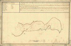
Plano del Puerto de Sn. Julián en la costa patagonica en la latitud de 49p0s 21ʹ S y en longitud de 310p0s, meridiano de Thenerife /
| Format |
Map |
|---|---|
| Contributors |
Taforo, Bernardo |
| Dates |
1780 |
| Location |
Argentina San JuliáN Bay San JuliáN Bay |
| Language |
Castilian Spanish |
| Subjects |
Argentina San JuliáN Bay San JuliáN Bay (Argentina) |
- Title
- Plano del Puerto de Sn. Julián en la costa patagonica en la latitud de 49p0s 21ʹ S y en longitud de 310p0s, meridiano de Thenerife /
- Description
-
Depths shown by soundings.
-
Oriented with north toward the lower left.
-
Prime meridian: Tenerife.
-
Watermark: J. Kool and Strasburg fleur-de-lis.
-
Pen-and-ink.
-
Mounted on cloth backing.
-
LC Luso-Hispanic World, 149
-
Available also through the Library of Congress Web site as a raster image.
-
Annotated in brown ink in lower left corner: 22.
-
Maggs number annotated in pencil in lower right margin: 74.
-
Includes index and notes.
-
1 map : ms. ; 34 x 71 cm.
- Creator
- Taforo, Bernardo.
- Created Published
-
[1780]
- Subject Headings
-
-
San Julián Bay (Argentina)
-
-
Argentina--San Julián Bay.
- Notes
-
-
Depths shown by soundings.
-
-
Oriented with north toward the lower left.
-
-
Prime meridian: Tenerife.
-
-
Watermark: J. Kool and Strasburg fleur-de-lis.
-
-
Pen-and-ink.
-
-
Mounted on cloth backing.
-
-
LC Luso-Hispanic World, 149
-
-
Available also through the Library of Congress Web site as a raster image.
-
-
Annotated in brown ink in lower left corner: 22.
-
-
Maggs number annotated in pencil in lower right margin: 74.
-
-
Includes index and notes.
- Medium
-
1 map : ms. ; 34 x 71 cm.
- Call Number
-
G5352.S253 1780 .T3
- Repository
-
Library of Congress Geography and Map Division Washington, D.C. 20540-4650 USA dcu
- Digital Id
-
g5352s lh000149 http://hdl.loc.gov/loc.gmd/g5352s.lh000149
- Library of Congress Catalog Number
- 89696458
Rights & Access
The maps in the Map Collections materials were either published prior to 1922, produced by the United States government, or both (see catalogue records that accompany each map for information regarding date of publication and source). The Library of Congress is providing access to these materials for educational and research purposes and is not aware of any U.S. copyright protection (see Title 17 of the United States Code) or any other restrictions in the Map Collection materials.
Note that the written permission of the copyright owners and/or other rights holders (such as publicity and/or privacy rights) is required for distribution, reproduction, or other use of protected items beyond that allowed by fair use or other statutory exemptions. Responsibility for making an independent legal assessment of an item and securing any necessary permissions ultimately rests with persons desiring to use the item.
More about Copyright and other Restrictions
For guidance about compiling full citations consult Citing Primary Sources.
Part of...
-
Cultural Landscapes
[1623]
-
Geography And Maps Division
[60803]
-
American Memory
[1121009]
More maps like this
-
 Descripción del Puerto d. Sn. Julián cituado en la latitd. S. de 49 grados 20 ms. y en la longd. de 310 grs., meridiano d. ...
Site:
American Memory-cultural, Main Catalog
Original Format:
Map
Date:
1700
View catalog record
Descripción del Puerto d. Sn. Julián cituado en la latitd. S. de 49 grados 20 ms. y en la longd. de 310 grs., meridiano d. ...
Site:
American Memory-cultural, Main Catalog
Original Format:
Map
Date:
1700
View catalog record
-
 Descripción del Puerto de Sn. Julián situado en la latitud S. de 49 grados 20 mins. y en la longd. de 310 grs., meridiano de ...
Site:
American Memory-cultural, Main Catalog
Original Format:
Map
Date:
1700
View catalog record
Descripción del Puerto de Sn. Julián situado en la latitud S. de 49 grados 20 mins. y en la longd. de 310 grs., meridiano de ...
Site:
American Memory-cultural, Main Catalog
Original Format:
Map
Date:
1700
View catalog record
-
 Descripción del Puerto de Sn. Julián situado en la latd. sur de 49 grados 20 mins. y en la longd. de 310 grados, merediano de ...
Site:
American Memory-cultural, Main Catalog
Original Format:
Map
Date:
1700
View catalog record
Descripción del Puerto de Sn. Julián situado en la latd. sur de 49 grados 20 mins. y en la longd. de 310 grados, merediano de ...
Site:
American Memory-cultural, Main Catalog
Original Format:
Map
Date:
1700
View catalog record
-
 Plano del Puerto de Sn. Gregorio situado en la latitud S. 45p0s4ʹ y en la longitud 310p0s54ʹ segun el meridiano de Tenerife /
Contributor:
Taforo, Bernardo
Site:
American Memory-cultural, Main Catalog
Original Format:
Map
Date:
1700
View catalog record
Plano del Puerto de Sn. Gregorio situado en la latitud S. 45p0s4ʹ y en la longitud 310p0s54ʹ segun el meridiano de Tenerife /
Contributor:
Taforo, Bernardo
Site:
American Memory-cultural, Main Catalog
Original Format:
Map
Date:
1700
View catalog record
-
 Plano del Pto. de Sn. José cituado en latd. S. 42 grs. y en longd. de 312 grs. y 1 mino., mro. de Tenerife /
Contributor:
Taforo, Bernardo
Site:
American Memory-cultural, Main Catalog
Original Format:
Map
Date:
1780
View catalog record
Plano del Pto. de Sn. José cituado en latd. S. 42 grs. y en longd. de 312 grs. y 1 mino., mro. de Tenerife /
Contributor:
Taforo, Bernardo
Site:
American Memory-cultural, Main Catalog
Original Format:
Map
Date:
1780
View catalog record
-
 Atlas del plano catastral de la República Argentina /
Contributor:
Chapeaurouge, Carlos de
Site:
American Memory-cultural, Main Catalog
Original Format:
Map
Date:
1905
View catalog record
Atlas del plano catastral de la República Argentina /
Contributor:
Chapeaurouge, Carlos de
Site:
American Memory-cultural, Main Catalog
Original Format:
Map
Date:
1905
View catalog record
-
 Atlas del plano catastral de la República Argentina /
Contributor:
Chapeaurouge, Carlos de
Site:
American Memory-cultural, Main Catalog
Original Format:
Map
Date:
1901
View catalog record
Atlas del plano catastral de la República Argentina /
Contributor:
Chapeaurouge, Carlos de
Site:
American Memory-cultural, Main Catalog
Original Format:
Map
Date:
1901
View catalog record
-
 Argentina.
Contributor:
United States. Central Intelligence Agency
Site:
American Memory-cultural, Main Catalog
Original Format:
Map
Date:
1996
View catalog record
Argentina.
Contributor:
United States. Central Intelligence Agency
Site:
American Memory-cultural, Main Catalog
Original Format:
Map
Date:
1996
View catalog record
-
 [Map showing coast of Argentina from 44p0s05ʹS to 49p0s52ʹS : Union Point to Port San Julián].
Site:
American Memory-cultural, Main Catalog
Original Format:
Map
Date:
1700
View catalog record
[Map showing coast of Argentina from 44p0s05ʹS to 49p0s52ʹS : Union Point to Port San Julián].
Site:
American Memory-cultural, Main Catalog
Original Format:
Map
Date:
1700
View catalog record
-
 Argentina.
Contributor:
United States. Central Intelligence Agency
Site:
American Memory-cultural, Main Catalog
Original Format:
Map
Date:
1996
View catalog record
Argentina.
Contributor:
United States. Central Intelligence Agency
Site:
American Memory-cultural, Main Catalog
Original Format:
Map
Date:
1996
View catalog record
-
 Puerto Deseado en los 47 gs. 50 ms. de latitud sur y en los 313 gs. 16 ms. de longd., variación 18 gs. NE la ...
Site:
American Memory-cultural, Main Catalog
Original Format:
Map
Date:
1787
View catalog record
Puerto Deseado en los 47 gs. 50 ms. de latitud sur y en los 313 gs. 16 ms. de longd., variación 18 gs. NE la ...
Site:
American Memory-cultural, Main Catalog
Original Format:
Map
Date:
1787
View catalog record
-
 [Map showing coast of Argentina from 42p0sS to 53p0sS (Chubut River to Strait of Magellan including Falkland Islands)].
Site:
American Memory-cultural, Main Catalog
Original Format:
Map
Date:
1700
View catalog record
[Map showing coast of Argentina from 42p0sS to 53p0sS (Chubut River to Strait of Magellan including Falkland Islands)].
Site:
American Memory-cultural, Main Catalog
Original Format:
Map
Date:
1700
View catalog record
-
 Puerto Deseado en los 47 gs. 50 ms. de latitud sur y en los 313 gs. 16 ms. de longd., variación 18 gs. N.E. la ...
Contributor:
García Diez, Miguel, García Diez, Miguel
Site:
American Memory-cultural, Main Catalog
Original Format:
Map
Date:
1787
View catalog record
Puerto Deseado en los 47 gs. 50 ms. de latitud sur y en los 313 gs. 16 ms. de longd., variación 18 gs. N.E. la ...
Contributor:
García Diez, Miguel, García Diez, Miguel
Site:
American Memory-cultural, Main Catalog
Original Format:
Map
Date:
1787
View catalog record
-
 Navegación de las corvetas de S.M. Descuvierta y Atrevida sovre la costa Patagonica, año d. 1789 /
Contributor:
Vico, Antonio
Site:
American Memory-cultural, Main Catalog
Original Format:
Map
Date:
1790
View catalog record
Navegación de las corvetas de S.M. Descuvierta y Atrevida sovre la costa Patagonica, año d. 1789 /
Contributor:
Vico, Antonio
Site:
American Memory-cultural, Main Catalog
Original Format:
Map
Date:
1790
View catalog record
-
 Argentina-Chile arbitral boundary.
Contributor:
United States. Central Intelligence Agency
Site:
American Memory-cultural, Main Catalog
Original Format:
Map
Date:
1969
View catalog record
Argentina-Chile arbitral boundary.
Contributor:
United States. Central Intelligence Agency
Site:
American Memory-cultural, Main Catalog
Original Format:
Map
Date:
1969
View catalog record
-
 Descripción de la Bahía de Camarons. situada en la latd. S. de 44 grs. 50 ms. y en la longitud de 310 grs. 50 ms. ...
Site:
American Memory-cultural, Main Catalog
Original Format:
Map
Date:
1700
View catalog record
Descripción de la Bahía de Camarons. situada en la latd. S. de 44 grs. 50 ms. y en la longitud de 310 grs. 50 ms. ...
Site:
American Memory-cultural, Main Catalog
Original Format:
Map
Date:
1700
View catalog record
You might also like
-

 Argentine: past, present and future.
Contributor:
Corthell, Elmer L[awrence]
Site:
Main Catalog
Original Format:
Book
Date:
1903
Argentine: past, present and future.
Contributor:
Corthell, Elmer L[awrence]
Site:
Main Catalog
Original Format:
Book
Date:
1903
-
Living and dying with hard pegs rise and fall of Argentina's Currency Board /
Contributor:
Torre, Augusto de la
Site:
Main Catalog
Original Format:
Book
Date:
2003
-
Income, wealth, and socialization in Argentina provocative responses from individuals /
Contributor:
Lederman, Daniel
Site:
Main Catalog
Original Format:
Book
Date:
2002
-
Autonomy, participation, and learning in Argentine schools findings and their implications for decentralization /
Contributor:
Eskeland, Gunnar S.
Site:
Main Catalog
Original Format:
Book
Date:
2002
-
Assisting the transition from workfare to work a randomized experiment /
Contributor:
Galasso, Emanuela
Site:
Main Catalog
Original Format:
Book
Date:
2001
-
Processes, information and accounting gaps in the regulation of Argentina's private railways
Contributor:
Campos-Méndez, Javier
Site:
Main Catalog
Original Format:
Book
Date:
2001