Maps of the city of Paterson
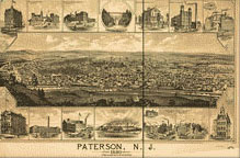
![]() 1880. (Library of Congress, Geography and Map Division).
1880. (Library of Congress, Geography and Map Division).

![]()
![]() 5 Drawings from Great Falls/S. U. M. Historic District, Oliver St., PATERSON, Passaic County, NJ. 1968. (Library of Congress, Prints and Photographs Division. Reproduction Number: HAER NJ-1, sheets 1 through 5 of 5)
5 Drawings from Great Falls/S. U. M. Historic District, Oliver St., PATERSON, Passaic County, NJ. 1968. (Library of Congress, Prints and Photographs Division. Reproduction Number: HAER NJ-1, sheets 1 through 5 of 5)

![]()
![]() Detail from "Photocopy of Map--1835: Town of Paterson, New Jersey...", from Great Falls/S.U.M. Historic District, Oliver St., PATERSON, Passaic County, NJ. 1968. (Library of Congress, Prints and Photographs Division. Reproduction Number: HAER, NJ,16-PAT,15-1).
Detail from "Photocopy of Map--1835: Town of Paterson, New Jersey...", from Great Falls/S.U.M. Historic District, Oliver St., PATERSON, Passaic County, NJ. 1968. (Library of Congress, Prints and Photographs Division. Reproduction Number: HAER, NJ,16-PAT,15-1).
Railway Maps

![]()
![]() Lines of the Paterson, Passaic, & Rutherford Electric R'y... 1894. (Library of Congress, Geography and Map Division).
Lines of the Paterson, Passaic, & Rutherford Electric R'y... 1894. (Library of Congress, Geography and Map Division).
![]()
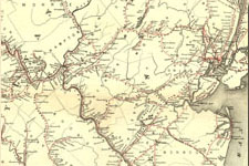
![]() Detail from Map of the rail roads of New Jersey... 1869. (Library of Congress, Geography and Map Division).
Detail from Map of the rail roads of New Jersey... 1869. (Library of Congress, Geography and Map Division).
![]()
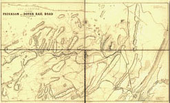
![]() Map and profile of the proposed Paterson and Dover Rail Road... c. 1847 (Library of Congress, Geography and Map Division).
Map and profile of the proposed Paterson and Dover Rail Road... c. 1847 (Library of Congress, Geography and Map Division).