Online Exhibition

Christopher Columbus (1451-1506)
Epistola . . . de Insulis
Indie nuper inventis (Letter
Concerning the Islands Recently Discovered. . . .).
Rome: Stephan Plannck, 1493
Jay I. Kislak Collection
Rare Book and Special
Collections Division (1)
|
Christopher Columbus's Account of 1492 Voyage
After his first transatlantic voyage, Christopher Columbus
sent an account of his encounters in the Americas to King
Ferdinand and Queen Isabella of Spain. Several copies of
his manuscript were made for court officials, and a transcription
was published in April 1493. This Latin translation by Leandro
de Cosco, based on a more accurate transcription of Columbus's
manuscript, was published the same year. In reporting on
his trip to his sovereigns, Columbus wrote with great enthusiasm
and conviction, as the following passage illustrates:
There I found very many islands, filled with innumerable
people, and I have taken possession of them all for their
Highnesses, done by proclamation and with the royal standard
unfurled, and no opposition was offered to me.
|
Spanish Treasure
In the age of piracy on the high seas, sailing instructions
were top-secret documents upon which rested the security
of the king's fleet and his treasure. Here, Menéndez
de Avilés, governor of Florida, gives Don Cristóbal
de Eraso complicated and detailed instructions for sailing
to Spain on the Buenaventura with his fleet, via the islands
of Flores and San Miguel. He is admonished not to proceed
beyond a designated rendezvous without further instructions
from Menéndez, "under penalty of paying with his person
and his property for any injury to his Majesty or his royal
treasury."
|

Pedro Menéndez de Avilés (1519-1574) to Don
Cristóbal de Eraso
Manuscript sailing orders, July
21, 1572
Jay I. Kislak Collection
Rare Book and Special
Collections Division (2)
|

Juan Eusebio Nieremberg (1595-1658)
Historia Naturae, Maxime
Peregrinæ, Libris XVI Distincta (A Natural History
of the Americas).
Antwerp: Ex Officina Plantiniana, Balthasaris Moreti, 1635
Jay I. Kislak Collection
Rare Book and Special
Collections Division (4)
|
The First Natural History of the Americas
This book, the only edition of this encyclopedic work, describes
and categorizes the flora and fauna of the Americas, particularly
of Mexico (New Spain), and provides information on the customs
and rites of the Aztecs and Incas. Because it includes the
indigenous names for the plants and animals described, the
work became an important linguistic document for the Nahuatl
language of Mexico and the Quechua language of the Andes.
|
Indian Rights
Dominican Priest Bartolomé de
Las Casas was a passionate champion of the rights of the
indigenous people of the Americas. Las Casas sailed from
Spain to Santo Domingo in 1502. There, he was given a royal
land grant including labor of the Indian inhabitants as a
reward for his participation in various expeditions. Horrified
by the Conquistadors' treatment of the Indians, he returned
to Spain in 1510 to take holy orders, determined to devote
his life to mission work in the Americas. In 1544 Las Casas
was named Bishop of Chiapas, Mexico, where he worked to alleviate
the burdens of colonialism on the Indians.
|

Bartolomé de Las Casas (1474-1566) to Holy Roman Emperor
Charles V (1500-1558)
Manuscript letter, ca. 1528
Jay I. Kislak Collection
Rare Book and Special
Collections Division (5)
|
Priest's handbook
Guatemalan highlands
Book cover - Page
2 - Page 3
Bound manuscript, ca. 1544-1570
Jay I. Kislak Collection
Rare Book and Special
Collections Division (6)
|
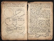
Handbook for Priests
This remarkable composite manuscript, in at least two Mayan
languages, as well as Latin and Spanish, was most likely
created by Dominican priests working with Indian populations
in the middle of the sixteenth century in the Guatemalan
highlands. It contains a variety of materials in Kekchi and
Quiché, including the lives of saints, religious instructions
and hymns, guidance on marital arrangements, and the Church
feast days. That such a book, destined for daily use, survived
at all is extraordinarily rare. It provides a unique window
into issues of cultural interaction and missionary practices
and experiences during the early period of contact.
|
Mapping a Land Claim
Indigenous cartographic conventions evident in this map
differ considerably from those of Europe in both conception,
social function, and artistic execution. To view this map
correctly, one must rotate it. Pre-Hispanic conventions include
the bell-shapes to denote a community and the trail of footprints
to depict a path or road. Images like this one visually portray
the legitimacy and public recognition of the local community,
and its rights to a territory.
|

Techialoyan land records
San Juan Tolcayuca
Mexico. Aztec, seventeenth century
Manuscript map on amate (fig tree bark) paper
Jay I. Kislak Collection
Rare Book and Special
Collections Division (7.1)
|

Don Andrés, Aztec notary
Techialoyan land records,
with text in Nahuatl
Santa Maria Itztacapan, Mexico. Aztec, seventeenth century
Manuscript on amate (fig tree bark) paper
Jay I. Kislak Collection
Rare Book and Special
Collections Division (7.2)
|
Land Rights from Aztec Tradition
As part of the annihilation of the Aztec civilization, after
Cortés conquered Montezuma's empire, the Spaniards
burned the Aztec archives. Surviving examples of Indian codices
are rare. Although this manuscript claims to date from the
early 1500s, it is part of the so-called "Techialoyan" land
records created in the seventeenth century using old methods
to substantiate native land claims with the Spanish regional
authorities. These "titulos primodiales" were essentially
municipal histories that documented in text and pictures
local accounts of important events and territorial boundaries.
|
Excavating Mayan Ruins
In 1787, the military governor of Guatemala sent soldier
Antonio del Río to excavate a Mayan ruin near Palenque,
marking the dawn of scientific archaeology in the Americas.
Del Río and his men spent two weeks clearing the site
and three more weeks studying, drawing, and exploring. Del
Río recounted the work in a remarkable report that
was illustrated with thirty drawings made by Ricardo Almendáriz.
Del Río's manuscript has been preserved in Madrid,
but the drawings were only recently found in a private European
collection.
|

Antonio del Río (fl. 1786-1789). Ill. by Ricardo Almendáriz.
Colección de Estampas Copiadas
de las Figuras . . . de Chiapas, una de las del Reyno de
Guatemala en la América Septentrional
[Palenque, Mexico: 1787]
View
entire manuscript
Brown ink drawings on paper
Jay I. Kislak Collection
Rare Book and Special
Collections Division (8)
|
![Façade of the Fourth Building of Maitta [Mitla], Province of Ojaca [Oaxaca]](images/kc0009s-th.jpg)
Claude Joseph Désiré Charnay (1828-1915)
"Façade of the Fourth Building of Maitta
[Mitla], Province of Ojaca [Oaxaca],"
Ruines du Mexique et Types Mexicans
Photographic album albumen prints, 1859-1860
Jay I. Kislak Collection
Rare Book and Special
Collections Division (9)
|
Early Photography in Mexico
This album of thirty-five albumen prints is from the first
systematic photographic expedition to the ruins at Mitla,
Izamal, Chichén Itzá, and Uxmal, Mexico. The
prints were made by the French photographer and explorer
Désiré Charnay during two seasons of fieldwork
in 1859 and 1860. Charnay's work was instrumental in attracting
serious scholarly interest in pre-conquest Mexico, thus setting
the stage for later intensive archaeological studies of Mesoamerican
civilization.
|
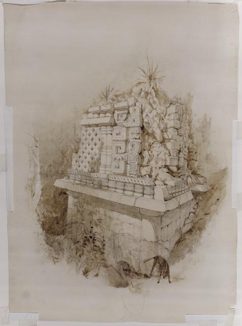
A Mayan Temple
This drawing is one of only a few originals not destroyed
by a disastrous fire in a New York gallery in July 1842.
John Lloyd Stephens, the outgoing American writer, and Frederick
Catherwood, a quiet English artist, were the first explorers
to accurately describe and illustrate the art of the pre-Hispanic
Maya of Mexico and Central America. Through their highly
popular publications (first published in 1841 and 1843 and
still in print today), they introduced the ancient Maya to
a world that knew little of their existence and stimulated
research on the Maya for generations.
|

Frederick Catherwood (1799-1854)
Study for Mayan monument, ca.
1842
Pencil and brown wash drawing on paper
Jay I. Kislak Collection
Rare Book and Special
Collections Division (10)
|
![The Creation [Illustration for Popol Vuh]](images/kc0011_1s-th.jpg)
Diego Rivera (1886-1957)
The Creation [Illustration
for Popol Vuh], ca. 1931
Watercolor and gouache on paper
Jay I. Kislak Collection
Rare Book and Special
Collections Division (11.1)
© Banco de Mexico Diego Rivera & Frida Kahlo Museums Trust
|
Diego Rivera and the Popol Vuh
The Popol Vuh recounts the religious beliefs and
legends of the ancient Quiché Maya, who inhabited
the highlands of Guatemala. Probably originally recited,
the text is thought to have been set down first in hieroglyphic
by indigenous writers in the 1550s, at the request of a Jesuit
priest. In the 1930s, Mexican artist, Diego Rivera, long
a champion of indigenous people, was commissioned to create
these illustrations for an English translation that was never
published of the Popol Vuh story.
The Popol Vuh begins with an account of the creation
of the world. In the center of this image are fully formed
figures of a male and a female, as well as two stiff awkward
human-like forms suggesting the three successive attempts
to fashion a human being, first out of clay, then wood, and
finally out of maize. Rivera may have begun the project with
this illustration, as it alone bears a full signature and
a color bar across the bottom, possibly to facilitate color
reproduction.
|
Human Sacrifice and the Popol Vuh
In this section of the Popol Vuh, one of the four
gods given to the first humans instructs them to perform
sacrifices in exchange for the gift of fire. The story reads, "They
should cut themselves open, that from under their ribs up
under their armpits their hearts should be torn out. Before
everything, sacrifice. By this you will obtain grace. Next,
make holes in your ears, and likewise prick your elbows and
knees. Offer as sacrifice the blood that flows from them.
In these ways, your gratitude will be shown."
|

Diego Rivera
Human Sacrifice Before
Tohil [Illustration for Popol Vuh], ca.
1931
Gouache on paper
Jay I. Kislak Collection
Rare Book and Special
Collections Division (11.3)
© Banco de Mexico Diego Rivera & Frida Kahlo Museums Trust
|
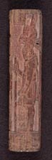
Tortuguero Box
A full-length portrait of a Mayan lord and forty-four hieroglyphic
signs are carved on all sides of this diminutive offering
box, one of very few surviving Mayan personal objects made
of wood. The text yields important insights into the complex
hierarchical Mayan social system. As we understand the text
today, the main protagonist is the lord depicted on the cover, Aj
K'ax B'ahlam, who held an important secondary office
under the patronage of the seventh-century Tortuguero king Ik'
Muyil Muwaahn II. The text concludes with the date the
box was made, October 14, A.D. 681, and names it the yotoot
mayij or "offering container" of Aj K'ax B'ahlam himself.
|

Tortuguero Box
Tabasco, Mexico. Maya, Classic Period, A.D. 681
Wood (sapodilla?) and red hematite
Jay I. Kislak Collection
Rare Book and Special
Collections Division (12)
|
{
Interactive Presentation }

Explore a 3D model of the
Tortuguero Box
allowing rotation and examination of the object.
View Interactive
Tortuguero Box
View Credits |
Top of
Box - Bottom of Box |
  |
  |
Story on a Vase
As in all societies where lineage serves political purposes,
the Maya kept dynastic lists in varied forms, including architectural
elements, sarcophagi, and ceramic objects. This vessel, with
its calligraphic hieroglyphs and restricted palette of red
and brown-black on cream, is part of a tradition called "codex
style" that is thought to mimic the appearance of Mayan books.
Most painted vessels of this type deal with mythological
topics, but this example is one of a small set that appears
to deal with historical information. The vase records the
names and dates of rulers associated with the city-state
of Calakmul in the Yucatan, Mexico.
|

Codex-style vase with sixty
hieroglyphs
Guatemalan lowlands. Maya, Late Classic Period, A.D. 700-900
Red and black on cream ceramic
Jay I. Kislak Collection
Rare Book and Special
Collections Division (13.1)
|
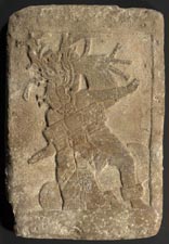
Mayan ball game [Plaque
from Site Q]
Guatemalan lowlands.
Maya, Late Classic Period, A.D. 550-950
Limestone
Jay I. Kislak Collection
Rare Book and Special
Collections Division (14)
|
Mayan Ball Game
This carved limestone plaque depicts a ceremonial ball game
scene. Scholars believe that, for the Maya, this ritual sport
was a reenactment of a mythological battle. Throughout Mesoamerica,
in many different forms, indigenous cultures practiced a
version of the ball game.
|
Mayan Jade
The front of this piece shows the face of a warrior, with
a supernatural animal headdress and jade earflares and collar.
There are five tiny holes for sewing the item to a garment.
The reverse side appears to have been carved at a later
time, perhaps as a war talisman. It is the image of a deity
sitting in lotus position with his head turned in profile.
His large square eye is ringed and the pupil is in the form
of a curl, typical of the Sun God. He wears a large belt,
and his arms are in the regal position in front of his body,
ready to receive a serpent bar.
|

Plaque carved on two sides,
with human face and animal headdress and deity in lotus position
Copán region, Honduras. Maya, Middle Classic Period,
A.D. 400-700
Reverse side
Green jade
Jay I. Kislak Collection
Rare Book and Special
Collections Division (15)
|

Xipe-Totec priest wearing flayed
human skin
Central Mexican Highlands. Aztec, A.D. 1400-1521
Painted volcanic basalt
Jay I. Kislak Collection
Rare Book and Special
Collections Division (17)
|
Mexican God Xipe-totec
Xipe-Totec, "our lord the flayed one," is manifested first
in Teotihuacan culture and continues in importance up to
Aztec times. He represents a fertility cult and was said
to assist the earth in making her new skin each spring. The
cult required the sacrifice of human victims by removing
the heart and, afterward, flaying the skin. The priests of
Xipe-Totec impersonated him by wearing a gold-dyed human
skin for twenty days, or until the skin rotted away. The
priest would then emerge reborn.
|
Ceremonial Wooden Stool
Preserved pre-Columbian duhos (ceremonial wooden stools)
from the Caribbean region are exceedingly rare, because they
are usually found only in dry highland caves. There are two
basic types: low horizontal forms with concave seats such
as this one and stools with long curved backrests. Scholars
differ as to the function of the stools. Some believe they
represented seats of authority. Others think they served
as altars for votive offerings. Still others argue that the
Taino peoples used them as ceremonial trays for making "cohoba," a
hallucinogenic snuff prepared for shamanistic rituals.
|

Duho (Ceremonial wooden stool)
Hispaniola. Taino, A.D. 1000-1500
Carved lignum vitae
Jay I. Kislak Collection
Rare Book and Special
Collections Division (20)
|

Seated male figure
Las Bocas, Mexico. Olmec, 1100-500 B.C.
Cream-slipped ceramic sculpture
Jay I. Kislak Collection
Rare Book and Special
Collections Division (21.2)
© Justin Kerr
|
Olmec Sculpture
The Olmec are considered one of the earliest civilizations
in Mesoamerica and the mother culture of later societies,
including the Maya. Their artifacts exhibit a high degree
of craftsmanship as demon-strated in this hand-modeled figure.
The flesh areas are burnished, but not the hair zone or the
split kilt. Red paint touches the tip of the nose, mouth,
and chin, as well as the waistline and toes. Body features
are picked out with incising, and tiny drill holes mark the
ears, nostrils, and mouth corners on this extremely naturalistic
figure.
|
Anecdotal Sculpture from 200 B.C.-A.D. 300
Ancient West Mexico was the home of a highly sophisticated
peoples, the Nayarit, that entombed their dead surrounded
by ceramic sculpture. Known as "anecdotal sculptures," these
types of models are a major source of information about ancient
ritual beliefs and everyday life. This unusually complex
model of a house, its two stories possibly representing life
on earth and the afterlife, shows occupants at a feast, with
musicians providing entertainment. Below the second level
porch, a man sleeps in a woman's lap. Three attendants climb
the steps, bearing containers of food and drink. Meanwhile,
three birds perch on the ledges of the second tier.
|

Large two-tiered house model
with fifteen inhabitants
Nayarit, West Mexico. 200 B.C.-A.D. 300
Painted red ceramic
Jay I. Kislak Collection
Rare Book and Special
Collections Division (22)
|

Hernando Cortés (1485-1547)
Dowry agreement for Montezuma's
daughter, June 27, 1526
Copied from a Spanish manuscript, [Valladolid], ca. 1750
Manuscript
Jay I. Kislak Collection
Rare Book and Special
Collections Division (24)
|
Dowry for Montezuma's Daughter
In this document, Hernando Cortés justifies a large
dowry to Doña Isabel, the late Emperor Montezuma's
(1480?-1520) eldest daughter, when she married a nobleman
of considerable standing in New Spain. Cortés recounts
the importance of Montezuma's aid to the Spanish during the
conquest of Mexico. Cortés, who served as guardian
for Montezuma's daughters and as Captain General of New Spain,
was a generous trustee, granting Doña Isabel lands,
several ranches, and Indian labor.
|
Francis Drake's Voyage in Early Maps
Italian artist Baptista Boazio created these handsome hand-colored
engravings to accompany A summarie and true discourse
of Sir Francis Drake's West Indian Voyage, published
in London by Biggs and Croftes in 1588-1589. The maps are
illustrated in fascinating detail with the fleet of twenty-three
ships, as well as land battle plans of the English attacks
on Spanish harbor forts. Animals, flags, crests, and compasses
decorate the cartography. These Boazio maps are historically
important not only for understanding Sir Francis Drake's
(1540?-1598) activities, but also because the four city plans
represent the first printed view of each locality.
The lead "voyage map," charting the round trip from England,
is captioned in English, while the accompanying four bird's-eye
views of ports are captioned in Latin. Drake sailed directly
west from Santiago in the Cape Verde Islands off the coast
of West Africa. The first port Drake reached in the West
Indies was Santo Domingo in Hispaniola, present-day Haiti
and Dominican Republic. This image shows the English fleet
in the bay, and the infantry battalions attacking the town.
The view of Cartagena, situated on the South American coast
of Colombia, depicts the English infantry marching on the
city. The view of St. Augustine is the earliest engraving
of any locality in the United States. It shows the English
fleet at anchor, while its infantry troops attack the Spanish
settlement.
|

Baptista Boazio (fl. 1588-1606)
View of entire route of Sir
Francis Drake's West Indian Voyage
Hand-colored engraving, 1589
Jay I. Kislak Collection
Rare Book and Special
Collections Division (25.1)
|

Baptista Boazio (fl. 1588-1606)
St. Augustine, Florida
Hand-colored engraving, 1589
Jay I. Kislak Collection
Rare Book and Special
Collections Division (25)
|

Baptista Boazio (fl. 1588-1606)
Santiago, Cape Verde
Hand-colored engraving, 1589
Jay I. Kislak Collection
Rare Book and Special
Collections Division (25.2)
|
![Santo Domingo [Dominican Republic]](images/kc0025.3s-th.jpg)
Baptista Boazio (fl. 1588-1606)
Santo Domingo [Dominican Republic]
Hand-colored engraving, 1589
Jay I. Kislak Collection
Rare Book and Special
Collections Division (25.3)
|
![Cartagena [Columbia]](images/kc0025.4s-th.jpg)
Baptista Boazio (fl. 1588-1606)
Cartagena [Colombia]
Hand-colored engraving, 1589
Jay I. Kislak Collection
Rare Book and Special
Collections Division (25.4)
|
The Meeting of Cortés and Montezuma
Painted in the latter half of the seventeenth century in
Mexico by unknown artists, the eight paintings in the Conquest
of Mexico series depict the encounter of Spanish and
Aztec cultures and the ultimate victory of the Spanish over
the native peoples. All eight paintings will be on display
in the permanent Kislak gallery. The painting displayed,
the third in the series, depicts Hernando Cortés (1485-1547)
meeting the Mexica emperor Montezuma (1480?-1520). The landscape
and treatment of indigenous dress serve to romanticize the
meeting of these two powerful leaders. Cortés approaches
Montezuma with his arms opened in a gesture of embrace, which
the Mexica leader respectfully rejects by raising his left
hand. Montezuma's idealized body, dignified stance, full
beard, and the golden sword in his right hand owe more to
European ideas about the appropriate bearing of a king than
to ethnographic accuracy. Furthermore, while the feather
skirts shown on Montezuma and his court were part of the
standard European iconography for depicting "Indians," skirts
like this are not known to have been worn anywhere in the
Americas.
|

Unknown artists
"The Meeting of Cortés and Montezuma,"
from the Conquest of Mexico series
Mexico, second half of seventeenth century
Oil on canvas
Jay I. Kislak Collection
Rare Book and Special
Collections Division (26.1)
|
Unknown artists.
"The Conquest of Tenochtitlán," from
the Conquest of México series
Mexico, second half of seventeenth century
Oil on canvas
Jay I. Kislak Collection
Rare Book and Special
Collections Division (26.2)
|
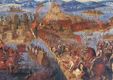
The Conquest of Tenochtitlán
The painting displayed, the seventh in the series, depicts
the conquest of Tenochtitlán (now the site of Mexico
City). The battle between the Spanish under Cortés
and the Mexica under the last Aztec leader Cuauhtémoc
is more properly called a siege. It began in May of 1521
and lasted into August. With newly built ships, the Spanish
controlled the lake surrounding the island and blockaded
the city. Ultimately Cortés ordered the complete destruction
of Tenochtitlán, including its palaces, temples, and
squares. This painting attempts to distill the excitement,
bloodshed, and drama of the siege into a single moment. Cortés
leads his Spanish armies across one of the causeways and
into the city. The captains of the other parts of his army
also lead their troops towards the center of the city and
the main temple compound. The Mexica put up a spirited and
skilled resistance, but by August the death of much of the
population, as well as months of scarce food and water, meant
that they could no longer defend the city. The surrender
of the survivors, the destruction of the main temple, and
the capture of Cuauhtémoc marked both the end of the
battle for Tenochtitlán and the end of Aztec empire.
|
Pirates in America
This is the first edition, in Dutch, of one of the most
important books about pirates ever written. Alexandre Exquemelin,
a native of Harfleur, went to the Caribbean in 1666 with
the French West Indies Company. He served as surgeon for
nearly ten years with various buccaneers and gives an eyewitness
account of the adventures of Henry Morgan, François
Lolonois, Pierre le Grand, and Bartholomew Portugues. Apart
from its obvious authenticity, Exquemelin's vivid writing
style narrates a story with color, drama, and vitality. His
descriptions are filled with vivid scenes of violence in
exotic locations, and this edition is enhanced with full-page
engravings of the buccaneers and their exploits.
|

Alexandre Olivier Exquemelin (1646-1707?)
De Americaensche Zee-Roovers (The
Buccaneers of America)
Amsterdam: Jan ten Hoorn, 1678
Jay I. Kislak Collection
Rare Book and Special
Collections Division (27)
{ Interactive Presentation }

Explore The Buccaneers of America with a 3D digital
model to simulate turning the pages of a real book.
Page
By Page Flash Presentation
(requires Macromedia
Flash Player)
Non-Flash
Presentation
Page By Page Flash Presentation: Russian
Translation
|
![Catecismo en lengua Timuquana, y Castellana, en el qual se instruyen y cathequizan los adultos infieles que an de sur Christianos. (Catechism in the Timuquan and Castilian [Spanish] languages. . . .)](images/kc0028s-th.jpg)
Francisco Pareja (d. 1628)
Catecismo en lengua Timuquana,
y Castellana, en el qual se instruyen y cathequizan los adultos
infieles que an de sur Christianos. (Catechism in
the Timuquan and Castilian [Spanish] languages. . . .)
Mexico: Juan Ruyz, 1627
Jay I. Kislak Collection
Rare Book and Special
Collections Division (28)
|
Catechism in Timucuan
This rare and important text is one of the earliest known
artifacts in any Indian language from what is now the United
States. Francisco Pareja came to Florida in 1595 and worked
among the native peoples for thirty-one years, particularly
among the Timucuan peoples. The systematic destruction of
Timucuan culture by the Spaniards makes even catechisms like
this one precious legacies of a world otherwise lost. No
other copies of this edition are known to exist. Father Pareja's
writings preserve almost all that is known about the Timucuan
language and customs.
|
Pensacola Seized from the British
This rare account of events during the American Revolutionary
War celebrates the Spanish seizure of Pensacola, Florida,
from the British by an expedition under Bernardo de Galvez
in May 1781. De Galvez's narrative poem, published in Madrid
in 1781, praises the victory that scholars believe broke
the British hold on Florida and was pivotal in ensuring that
Spain, an ally of the United States, would gain Florida at
the 1783 Treaty of Paris that ended the war.
|

Bernardo de Galvez (1746-1786)
Noticiosa, Verica Triumfante,
y Victoriosa Relacion Que Declara . . . La Restauracion De
La Plaza De Panzacola, La Florida . . . El Dia 8. Mayo De
1781 (An account of
the truly triumphant and victorious events of the capture
of Pensacola, Florida . . . on May 8, 1781)
Seville, 1781
Pamphlet
Jay I. Kislak Collection
Rare Book and Special
Collections Division (31)
|
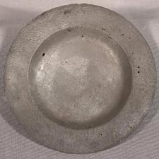
A Spanish Galleon Wrecks in 1622
During the centuries of Spanish exploration and colonization,
treasure fleets made regular trips to the Americas to deliver
merchandise and collect treasures and precious metals. In
late summer merchant ships would join their protectors, the
war galleons, in Havana to form the treasure fleet for the
return to Spain. Often, however, ships were scattered because
of bad weather, poor seamanship, or piracy. In early September
1622, Nuestra Señora de Atocha, a galleon carrying
tons of Spanish treasure, was wrecked on the Florida coral
reefs near the Dry Tortugas, leaving only five survivors.
These items were recovered from the site of the wreck.
|
 |
 |
 |
 |
Silver
fork, spoon, plate,
and gold bullion from
the 1622 Nuestra Señora de Atocha wreck
Jay I. Kislak Collection
Rare Book and Special
Collections Division (32, 32.1, 32.2, 32.3)
|
George Washington's Diary
Both a manuscript and a printed book, George Washington's
1762 almanac records activities at his Mount Vernon plantation.
He describes mainly planting tobacco and raising cattle and
sheep, although finance and slaves are also mentioned. Washington
kept a diary from 1747, when he was a teenaged surveyor,
until his death in 1799, with the notable exception of the
period of most of the Revolutionary War. With this addition,
the Library of Congress now holds thirty-seven of the forty-one
known original Washington diaries.
|

George Washington (1732-1799)
The Virginia Almanack for
the Year of our Lord God 1762
Williamsburg: Joseph Royle, and Co., 1762
Printed almanac with manuscript diary entries
Jay I. Kislak Collection
Rare Book and Special
Collections Division (33)
|
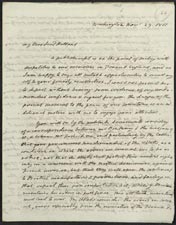
James Monroe (1758-1831) to Lord Henry Holland (1773-1840)
Manuscript letter, November
29, 1811
Image 2
Jay I. Kislak Collection
Rare Book and Special
Collections Division (34)
|
Unsuccessful Diplomacy
In this letter to Lord Holland of Great Britain, then Secretary
of State James Monroe warns that continued British repression
of American commerce will ultimately lead to war. It is part
of a small archive of treaty drafts, memoranda, reports,
and letters related to the unratified Anglo-American treaty
of 1806. It attempts to resolve issues diplomatically to
avert a war. Although successfully negotiated, the treaty
was quickly repudiated by President Thomas Jefferson because
it did not end impressment of American citizens into the
British Navy. As Monroe had warned, the unresolved issues
did lead to a crisis and eventually to the War of 1812.
|
U.S. Acquires Florida
When the United Status purchased the Louisiana Territory
in 1803, its boundaries were left very vague. In the Adams-Onis
Treaty of 1819, U.S. Secretary of State John Quincy Adams
had acquired Spanish Florida for $5 million and established
the southern and western boundaries of Louisiana and the
Spanish Territory. This letter is one of thirteen, written
over a two-year period, by John Adams to Don Francisco Vives
on the United States-Florida boundary. These letters shed
light not only on the specific difficulties regarding the
treaty but also the tenor of diplomatic dialogue during this
period of United States history. Each letter is annotated
on the back with a summary of the contents in Spanish.
|

John Quincy Adams (1767-1848) to Don Francisco Vives
Manuscript letter, May 6,
1820
Page 2 - Page
3 - Page 4
Page 5 - Page
6 - Page 7
Jay I. Kislak Collection
Rare Book and Special
Collections Division (35)
|
René de Laudonnière (fl. 1562-1582)
L'histoire Notable de la
Florida (A Noteworthy
History of Florida).
Paris: Auvray, 1586
Jay I. Kislak Collection
Rare Book and Special
Collections Division (36)
|
Heretics and Assassins
This sixteenth-century history of Florida, in its original
binding, includes narratives of four separate French expeditions
and the first description of Florida Indians. In 1564, René de
Laudonnière and Jean Ribault tried to establish a
French Huguenot colony near what is now Jacksonville. Within
a few months, a Spanish fleet attacked and massacred the
garrison hanging most of the French Huguenots affixed with
the inscription "Not as Frenchmen, but as heretics." Laudonnière
escaped and returned to France and wrote this book, describing
Captain Dominique de Gourgues' voyage to Florida in 1567
to avenge the murder of his countrymen. His expedition captured
two Spanish forts and hanged eight of the Spanish Catholic
prisoners, marked with the inscription, "Not as Spaniards,
but as assassins."
|
The Gulf Stream
As Surveyor-General of Lands for the newly created Southern
District of North America and the recently established colony
of East Florida, William [Gerard] de Brahm (1717-ca.1799),
an immigrant from Germany, was ordered to undertake a detailed
geographic survey of Florida--a land virtually unknown to
the British at that time. His observations, gathered over
the course of an eighteen-week expedition, provided a starting
point for all future investigations regarding the shape of
the peninsula and the circulation of the Gulf Stream.
|

William [Gerard] de Brahm
The Atlantic Pilot.
London: T. Spilsbury, 1772
Bound volume with engraved foldout maps
Jay I. Kislak Collection
Rare Book and Special
Collections Division (37)
|

Simon Grynaeus (1493-1541) and Johann Huttich (1490-1544).
Novus Orbis Regionum ac Insularum
Veteribus Incognitarum.
(A New Region of the World. . . .).
Basel: Johann Hervagius, 1532
Jay I. Kislak Collection
Rare Book and Special
Collections Division (38)
|
The Sixteenth-Century World
This early anthology of the lands and peoples of the Americas,
includes letters and descriptions of the voyages of Marco
Polo, Columbus, and Vespucci. A truly remarkable feature
of the work is a world map, possibly drawn by Sebastian Münster,
and, in part, by Hans Holbein the Younger. The Americas are
clearly depicted, based partly on the world as configured
by the Johann Schöner globes or on Peter Apian's map
of 1520, and showing the influence of the ideas of Copernicus.
The scenes and vignettes that surround the oval projection
are particularly interesting images, reflecting European
views of this new world as a place where cannibals, monsters,
and other dangers lurked.
|
Horatio Nelson
In 1784, Captain Horatio Nelson was given command of the
Boreas, a twenty-eight-gun frigate, with orders to enforce
the British Navigation Acts that required all imports be
carried in English ships. The acts had become a major problem
after the end of the American Revolution because American
vessels dominated trade between the West Indies and the former
colonies. When Nelson seized four illegally laden American
ships that had obviously violated the Navigation Acts, the
captains sued him for illegal seizure. In the ensuing trial,
the judge eventually found in favor of the British navy.
However, to avoid arrest and imprisonment, Nelson spent nearly
eight months aboard his frigate.
|

Horatio Nelson (1758-1805)
"Account of the proceedings of Captain Nelson of
His Majesty's Ship Boreas relative to the illegal trade carried on between the
Americans & the British West India Islands, March 20, 1785."
Bound manuscript, 1784-1786
Jay I. Kislak Collection
Rare Book and Special
Collections Division (39)
|
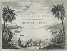
Thomas Jeffreys (1695-1771)
The West India Atlas:
or a Compendious Description of the West Indies: Illustrated
with Forty Correct Charts and Maps Taken from Actual Surveys.
Together with an Historical Account of the Several Countries
and Islands which Compose that Part of the World.
London: Robert Sayer and John Bennett, 1780
Jay I. Kislak Collection
Rare Book and Special
Collections Division (40)
|
Jeffreys Atlas
This volume was the first comprehensive British atlas of
Florida and the Caribbean. It includes the first large, detailed
printed maps of a number of Caribbean islands, such as Antigua,
St. Christopher, and Barbados. On many of these individual
maps, the topography is rendered with particular skill. They
provide unprecedented interior detail documenting the sugar
industry, slave life, roads, trade routes, and even individual
homes and estates. The atlas exemplifies the qualities that
ushered in a period of dominance for British chartmaking
related to the Americas.
|
Mayan Flasks
The Kislak Collection includes approximately 170 Mayan flasks
that vary in detail and size. Most, according to recent scholarship,
contained "May," a mixture of powdered native tobacco and
calcareous lime used for ritual and magical protection. Each
flask is decorated with images or glyphs representing the
intended use. The five flasks displayed represent the variety
of bottles in the collection.
|

Selection of Mayan flasks
Flask 1 - Flask
2 - Flask 3 - Flask
4 - Flask 5
Ceramic, Mexico. Maya, Classic Period, A.D. 600-900
Jay I. Kislak Collection
Rare Book and Special
Collections Division (41.1-41.5)
|
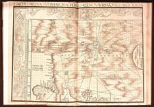
Martin Waldseemüller.
Carta Marina Navigatoria Portugallen
Navigationes Atque Tocius Cogniti Orbis Terre Maris. . .
.
(Carta Marina: a Portuguese Navigational Sea-Chart
of the Known Earth and Oceans. . . .).
Saint-Dié-desVosges, France, 1516.
Jay I. Kislak Collection
Rare Book and Special
Collections Division (43)
|
Martin Waldseemüller's 1516 Carta Marina
In 1507 Martin Waldseemüller, learned humanist and
celebrated cartographer, created a world map that follows
the traditional Ptolemaic outline of the world, except for
major additions in southern Africa and all of America. The
map's claim to immortality is contained in the simple word "America," based
on Waldseemüller's recognition that Amerigo Vespucci
had identified the newly found lands as a new part of the
world.
Waldseemüller's 1516 Carta Marina sought to
present the most up-to-date conception of the world at that
time. Equal in size to the 1507 map, the Carta Marina is
markedly superior to the earlier map in artistic detail,
reflecting possibly the hand of the artist Albrecht Dürer,
and incorporates greatly expanded and corrected geographical
information. The Carta Marina could be considered
the first printed nautical map of the entire world. However,
in part because of the controversies surrounding his naming
the Western Hemisphere "America," the word is omitted from
the Carta Marina, and the Western Hemisphere is
joined with Asia.
Long thought to be lost, the Waldseemüller maps were
rediscovered in 1901 by Father Josef Fischer, a Jesuit historian,
in the library of Prince Johannes von Waldburg zu Wolfegg-Waldsee
at the Castle of Wolfegg, in Württemberg, Germany. They
were in mint condition, carefully bound together inside a
folio. In 2003, the Library of Congress acquired the 1507
map, and the Kislak Collection, the Carta Marina.
|
Gallery of Additional Objects from the Kislak Collection

MONUMENTAL JAGUAR SCULPTURE
Mexico, Southern Veracruz. Late Classic, A.D. 600-900
Painted buff ceramic.
Ht. 63.5 cm. (25")
[P] 91.124.0.1
Digital ID# kc0050
© Justin Kerr
|

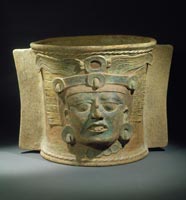
PRIEST IN
GUISE OF RAIN GOD "TLALOC"
Central Mexican Highlands. Aztec culture, A.D. 1400-1521
Volcanic basalt with traces of red pigment.
Ht. 60 cm. (23")
[F] 91.127.0.1
Digital ID# kc0063
© Justin Kerr
|

HOLLOW WARRIOR WITH JAGUAR
HELMET
Central Mexican Highlands. Mixtec culture, A.D. 1200-1500
Polychromed ceramic. Ht. 65 cm. (25")
[F] 88.16.0.1
Digital ID# kc0062
© Justin Kerr
|

FLARING CODEX-STYLE VASE: SEATED RULER
AND DWARF
Guatemalan Lowlands. Late Classic Maya, A.D. 700 -900
Red-rimmed, black-on-cream ceramic.
Ht. 10 cm. (4); Diam 11.5 cm. (4 1/2")
[F] 88.57.0.1 K4113
Digital ID# kc0064
© Justin Kerr
|

CEREMONIAL BIRD-EFFIGY METATE
Costa Rica, Atlantic watershed. A.D. 300-700
Carved volcanic stone.
L. 77.5 cm. (30"). Ht. 38 cm. (15")
[P] 91.142.0.1
Digital ID# kc0060
© Justin Kerr
|

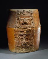
TWO-PART CACHE-VESSEL WITH
APPLIED GOD HEADS
Guatemalan Lowlands. Early Classic Maya, A.D. 200-600
Painted ceramic.
Total Ht. 45 cm. (17 3/4"); Diam. 30 cm. (11 7/8")
[F] 88.16.0.2 K6323
Digital ID# kc0061
© Justin Kerr
|

LARGE JADE PLAQUE: FAT LORD
AND FROG
Guatemalan Lowlands. Late Classic Maya, A.D.700-900
Light green jade.
L. 11.8 cm. (4 1/8"); Ht. 7.7 cm. (3");
D. 1.3 cm. (1/2")
[F] 91.106.0.1 K6378
Digital ID# kc0058
© Justin Kerr
|

SMALL VASE WITH HIGH-RELIEF
DIVING GOD
Mexico, Quintana Roo. Postclassic Maya, A.D. 1200-1400
Unslipped red ceramic with post-fire polychrome pigment.
Hts. (left to right): 11.4 cm. (4"); 11 cm. (4"); 9.3 cm. (3")
[F] 91.179.0.3
Digital ID# kc0059
© Justin Kerr
|

CARVED STONE MASK
Mexico; provenience unknown. Olmec culture, 900-500 B.C.
Mottled greenstone. Ht. 13.3 cm. (5")
[F] 91.120.0.2
Digital ID# kc0057
© Justin Kerr
|

HOLLOW KNEELING MALE FIGURE
West Mexico, Jalisco. Terminal Preclassic, 200 B.C.-A.D. 300
Burnished ceramic.
Ht. 33 cm. (13")
[F] 84.3.0.1
Digital ID# kc0056
© Justin Kerr
|
LARGE BURIAL URN WITH RELIEF GOD HEAD
Guatemalan Highlands; Quiche. Late Classic Maya, A.D. 700-900
Painted buff ceramic.
Ht. 53 cm. (20 3/4")
[F] 91.165.0.1 K6401
Digital ID# kc0055
© Justin Kerr
|

LARGE BI-CONICAL INCENSE BURNER
Mexico, Veracruz. Mixtec culture, A.D. 1200-1500
Red, blue, and white painted ceramic.
Ht. 52.5 cm. (20"); Diam. 68.5 cm. (27")
[F] 92.95.0.1
Digital ID# kc0054
© Justin Kerr
|

HOLLOW STANDING FEMALE FIGURE
Mexico, Southern Veracruz. Nopiloa style, A.D. 600-900
Painted tan ceramic.
Ht. 24.5 cm. (9")
[F] 90.46.0.2
Digital ID# kc0053
© Justin Kerr
|

LARGE CYLINDRICAL VASE WITH EFFIGY HANDLES
Honduras; Ulua Valley. Late Classic Maya, A.D. 600-900
White alabaster with traces of red cinnabar.
Ht. 18.5 cm. (7 1/2")
[F] 83.7.0.1 K6310
Digital ID# kc0051
© Justin Kerr
|
TWO-PART CACHE VESSEL WITH APPLIED GOD
HEADS
Guatemalan Lowlands. Early Classic Maya,,A.D. 200-600
Painted ceramic.
Total Ht. 24.8 cm. (9 3/4");
Diam. 20.5 cm.(8")
[F] 84.2.0.1 K6324
Digital ID# kc0052
© Justin Kerr
|
|
|


![Façade of the Fourth Building of Maitta [Mitla], Province of Ojaca [Oaxaca]](images/kc0009s.jpg)
![The Creation [Illustration for Popol Vuh]](images/kc0011_1s.jpg)


![Santo Domingo [Dominican Republic]](images/kc0025.3s.jpg)
![Cartagena [Columbia]](images/kc0025.4s.jpg)


![Catecismo en lengua Timuquana, y Castellana, en el qual se instruyen y cathequizan los adultos infieles que an de sur Christianos. (Catechism in the Timuquan and Castilian [Spanish] languages. . . .)](images/kc0028s.jpg)

![Plan of Matance's [Mantanzas] Fort, 1743](images/kc0030p2s.jpg)


