Map
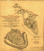
Sketch of the battlefield of Logan's Cross Roads : U.S. forces under the command of Major General G. H. Thomas, forces of the enemy commanded by Gen. G. B. Crittenden, Jan 19th., 1862 /
Views

More Views

| Format |
Map |
|---|---|
| Contributors |
Michler, N. |
| Dates |
1862 |
| Location |
Kentucky Mill Springs United States |
| Language |
English |
| Subjects |
Battle Of Kentucky Ky Mill Springs Mill Springs, Battle Of, Ky United States |
- Title
- Sketch of the battlefield of Logan's Cross Roads : U.S. forces under the command of Major General G. H. Thomas, forces of the enemy commanded by Gen. G. B. Crittenden, Jan 19th., 1862 /
- Description
-
Sun print.
-
Description derived from published bibliography.
-
LC Civil War maps (2nd ed.), 221
-
Available also through the Library of Congress Web site as a raster image.
-
LC Copy annotated in red and blue ink, showing four positions of Union and Confederate soldiers, troop camps, location of graves, roads, drainage, vegetation, houses, and fences. DLC
-
1 map : photocopy ; 28 x 23 cm.
- Creator
- Michler, N.
- Created Published
-
[S.l. : s.n.], 1862.
- Subject Headings
-
-
Mill Springs, Battle of, Ky., 1862.
-
-
United States--Kentucky--Mill Springs.
-
-
Mill Springs, Battle of, Ky.
- Notes
-
-
Sun print.
-
-
Description derived from published bibliography.
-
-
LC Civil War maps (2nd ed.), 221
-
-
Available also through the Library of Congress Web site as a raster image.
-
-
LC Copy annotated in red and blue ink, showing four positions of Union and Confederate soldiers, troop camps, location of graves, roads, drainage, vegetation, houses, and fences. DLC
- Medium
-
1 map : photocopy ; 28 x 23 cm.
- Call Number
-
G3952.M5 1862 .M52
- Repository
-
Library of Congress Geography and Map Division Washington, D.C. 20540-4650 USA dcu
- Digital Id
-
g3952m cw0221000a http://hdl.loc.gov/loc.gmd/g3952m.cw0221000a
-
g3952m cw0221000b http://hdl.loc.gov/loc.gmd/g3952m.cw0221000b
- Library of Congress Catalog Number
- 2008621648
Rights & Access
The maps in the Map Collections materials were either published prior to 1922, produced by the United States government, or both (see catalogue records that accompany each map for information regarding date of publication and source). The Library of Congress is providing access to these materials for educational and research purposes and is not aware of any U.S. copyright protection (see Title 17 of the United States Code) or any other restrictions in the Map Collection materials.
Note that the written permission of the copyright owners and/or other rights holders (such as publicity and/or privacy rights) is required for distribution, reproduction, or other use of protected items beyond that allowed by fair use or other statutory exemptions. Responsibility for making an independent legal assessment of an item and securing any necessary permissions ultimately rests with persons desiring to use the item.
More about Copyright and other Restrictions
For guidance about compiling full citations consult Citing Primary Sources.
Part of...
-
Civil War Maps
[2281]
-
Military Battles And Campaigns Cartographic Items
[3867]
-
Geography And Maps Division
[60803]
-
American Memory
[1121009]
More maps like this
-
 Sketch of the battlefield of Logan's Cross Roads and of the enemys fortified position at and opposite Mill Spring, Ky. to which he retreated after ...
Contributor:
Michler, N.
Site:
American Memory-cultural, Main Catalog
Original Format:
Map
Date:
1877
View catalog record
Sketch of the battlefield of Logan's Cross Roads and of the enemys fortified position at and opposite Mill Spring, Ky. to which he retreated after ...
Contributor:
Michler, N.
Site:
American Memory-cultural, Main Catalog
Original Format:
Map
Date:
1877
View catalog record
-
 Sketch of the battlefield of Logan's Cross Roads and of the enemys fortified position at and opposite Mill Spring, Ky. to which he retreated after ...
Contributor:
Michler, N.
Site:
American Memory-cultural
Original Format:
Map
Date:
1877
Sketch of the battlefield of Logan's Cross Roads and of the enemys fortified position at and opposite Mill Spring, Ky. to which he retreated after ...
Contributor:
Michler, N.
Site:
American Memory-cultural
Original Format:
Map
Date:
1877
-
 Fredericksburg. [Dec. 1862] /
Contributor:
Michler, N.
Site:
American Memory-cultural, Main Catalog
Original Format:
Map
Date:
1867
View catalog record
Fredericksburg. [Dec. 1862] /
Contributor:
Michler, N.
Site:
American Memory-cultural, Main Catalog
Original Format:
Map
Date:
1867
View catalog record
-
 Fredericksburg. [Dec. 1862]
Contributor:
Michler, N.
Site:
American Memory-cultural, Main Catalog
Original Format:
Map
Date:
1867
View catalog record
Fredericksburg. [Dec. 1862]
Contributor:
Michler, N.
Site:
American Memory-cultural, Main Catalog
Original Format:
Map
Date:
1867
View catalog record
-
 Totopotomoy [1864]
Contributor:
Michler, N.
Site:
American Memory-cultural, Main Catalog
Original Format:
Map
Date:
1867
View catalog record
Totopotomoy [1864]
Contributor:
Michler, N.
Site:
American Memory-cultural, Main Catalog
Original Format:
Map
Date:
1867
View catalog record
-
 Antietam.
Contributor:
Michler, N.
Site:
American Memory-cultural, Main Catalog
Original Format:
Map
Date:
1867
View catalog record
Antietam.
Contributor:
Michler, N.
Site:
American Memory-cultural, Main Catalog
Original Format:
Map
Date:
1867
View catalog record
-
 Harper's Ferry [1863]
Contributor:
Michler, N.
Site:
American Memory-cultural, Main Catalog
Original Format:
Map
Date:
1867
View catalog record
Harper's Ferry [1863]
Contributor:
Michler, N.
Site:
American Memory-cultural, Main Catalog
Original Format:
Map
Date:
1867
View catalog record
-
 Cold Harbor. [June 1-3, 1864]
Contributor:
Michler, N.
Site:
American Memory-cultural, Main Catalog
Original Format:
Map
Date:
1887
View catalog record
Cold Harbor. [June 1-3, 1864]
Contributor:
Michler, N.
Site:
American Memory-cultural, Main Catalog
Original Format:
Map
Date:
1887
View catalog record
-
 Chancellorville [sic] [May 1-3, 1863] /
Contributor:
Michler, N.
Site:
American Memory-cultural, Main Catalog
Original Format:
Map
Date:
1863
View catalog record
Chancellorville [sic] [May 1-3, 1863] /
Contributor:
Michler, N.
Site:
American Memory-cultural, Main Catalog
Original Format:
Map
Date:
1863
View catalog record
-
 Sketch of the battlefield of Shiloh : showing the disposition of the troops under the command of Major General D.C. Buell, on the 6th and ...
Contributor:
Michler, N.
Site:
American Memory-cultural, Main Catalog
Original Format:
Map
Date:
1862
View catalog record
Sketch of the battlefield of Shiloh : showing the disposition of the troops under the command of Major General D.C. Buell, on the 6th and ...
Contributor:
Michler, N.
Site:
American Memory-cultural, Main Catalog
Original Format:
Map
Date:
1862
View catalog record
-
 Antietam /
Contributor:
Michler, N.
Site:
American Memory-cultural, Main Catalog
Original Format:
Map
Date:
1867
View catalog record
Antietam /
Contributor:
Michler, N.
Site:
American Memory-cultural, Main Catalog
Original Format:
Map
Date:
1867
View catalog record
-
 Antietam.
Contributor:
Michler, N.
Site:
American Memory-cultural, Main Catalog
Original Format:
Map
Date:
1867
View catalog record
Antietam.
Contributor:
Michler, N.
Site:
American Memory-cultural, Main Catalog
Original Format:
Map
Date:
1867
View catalog record
-
 Cold Harbor. [June 1-3, 1864]
Contributor:
Michler, N.
Site:
American Memory-cultural, Main Catalog
Original Format:
Map
Date:
1867
View catalog record
Cold Harbor. [June 1-3, 1864]
Contributor:
Michler, N.
Site:
American Memory-cultural, Main Catalog
Original Format:
Map
Date:
1867
View catalog record
-
 Chancellorville [sic] [May 1-3, 1863]
Contributor:
Michler, N.
Site:
American Memory-cultural, Main Catalog
Original Format:
Map
Date:
1863
View catalog record
Chancellorville [sic] [May 1-3, 1863]
Contributor:
Michler, N.
Site:
American Memory-cultural, Main Catalog
Original Format:
Map
Date:
1863
View catalog record
You might also like
-
 That southern wagon
Contributor:
Hays, Will S., Composer, Jerry Blossom
Site:
Performing Arts Encyclopedia
Original Format:
Music Score
That southern wagon
Contributor:
Hays, Will S., Composer, Jerry Blossom
Site:
Performing Arts Encyclopedia
Original Format:
Music Score
-
 Christiancy and Pickett families' papers, 1835-1998
Site:
Finding Aids, Main Catalog
Original Format:
Manuscript
View catalog record
Christiancy and Pickett families' papers, 1835-1998
Site:
Finding Aids, Main Catalog
Original Format:
Manuscript
View catalog record
-

 Mr. Powell's defense.
Contributor:
Powell, Lazarus Whitehead
Site:
Main Catalog
Original Format:
Book
Date:
1862
Mr. Powell's defense.
Contributor:
Powell, Lazarus Whitehead
Site:
Main Catalog
Original Format:
Book
Date:
1862
-
 50th Congress Kentucky delegates
Site:
Prints & Photographs, Main Catalog
Original Format:
Photo, Print, Drawing
Date:
1887
View catalog record
50th Congress Kentucky delegates
Site:
Prints & Photographs, Main Catalog
Original Format:
Photo, Print, Drawing
Date:
1887
View catalog record
-
Almon Ferdinand Rockwell papers, 1852-1900
Contributor:
Rockwell, Almon Ferdinand
Site:
Finding Aids, Main Catalog
Original Format:
Manuscript
View catalog record
-
Burbank-Van Voorhis families papers, 1814-1913
Site:
Finding Aids, Main Catalog
Original Format:
Manuscript
View catalog record