California
as an Island
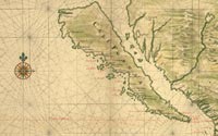
Johannes Vingboons
[Map of Baja California Shown as
an Island], 1639
Manuscript map
Geography & Map Division
Gift of Henry Harisse, 1915 (110.10)
|
One of the major geographic misconceptions originating during the
discovery and exploration of North America was the depiction of
California as an island. Based on erroneous Spanish manuscript accounts,
European cartographers began in 1622 to portray the western coast
of North America as a separate island. Major publishers, especially
the British and the Dutch, accepted this concept well into the early
eighteenth century, long after Father Eusebio Kino confirmed during
exploration of the American southwest from 1698 to 1701 that California
was not an island. Shown here is one of fourteen manuscript maps
acquired by the great nineteenth-century collector of Americana,
Henry Harisse.
|

