Map
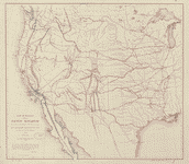
Map of the central portion of the United States showing the lines of the proposed Pacific railroads.

| Format |
Map |
|---|---|
| Location |
United States |
| Language |
English |
| Subjects |
Railroads Union Pacific Railroad Company United States |
- Title
- Map of the central portion of the United States showing the lines of the proposed Pacific railroads.
- Description
-
Scale ca. 1:6,500,000.
-
LC Railroad maps, 15
-
Description derived from published bibliography.
-
Strip map of the United States between 36 degrees and 47 degrees north latitude. Shows drainage, relief by hachures, state boundaries, place names, and some trails in the western half of the map. Indicates the proposed lines for the western, central, and eastern divisions of the Union Pacific Railroad.
-
Available also through the Library of Congress Web site as a raster image.
-
map 19 x 77 cm.
- Created Published
-
[New York, 185?]
- Subject Headings
-
-
Union Pacific Railroad Company
-
-
Railroads--United States
-
-
United States.
- Notes
-
-
Scale ca. 1:6,500,000.
-
-
LC Railroad maps, 15
-
-
Description derived from published bibliography.
-
-
Strip map of the United States between 36 degrees and 47 degrees north latitude. Shows drainage, relief by hachures, state boundaries, place names, and some trails in the western half of the map. Indicates the proposed lines for the western, central, and eastern divisions of the Union Pacific Railroad.
-
-
Available also through the Library of Congress Web site as a raster image.
- Medium
-
map 19 x 77 cm.
- Call Number
-
G3701.P3 185- .M3
- Repository
-
Library of Congress Geography and Map Division Washington, D.C. 20540-4650 USA dcu
- Digital Id
-
g3701p rr000150 http://hdl.loc.gov/loc.gmd/g3701p.rr000150
- Library of Congress Catalog Number
- 98688310
Rights & Access
The maps in the Map Collections materials were either published prior to 1922, produced by the United States government, or both (see catalogue records that accompany each map for information regarding date of publication and source). The Library of Congress is providing access to these materials for educational and research purposes and is not aware of any U.S. copyright protection (see Title 17 of the United States Code) or any other restrictions in the Map Collection materials.
Note that the written permission of the copyright owners and/or other rights holders (such as publicity and/or privacy rights) is required for distribution, reproduction, or other use of protected items beyond that allowed by fair use or other statutory exemptions. Responsibility for making an independent legal assessment of an item and securing any necessary permissions ultimately rests with persons desiring to use the item.
More about Copyright and other Restrictions
For guidance about compiling full citations consult Citing Primary Sources.
Part of...
-
Railroad Maps, 1828 1900
[617]
-
Transportation And Communication Cartographic Items
[761]
-
Geography And Maps Division
[60803]
-
American Memory
[1121009]
More maps like this
-
 Map and profile of first 40 miles of Union Pacific Rail Road Eastern Division extending west from boundary between states of Missouri and Kansas,
Contributor:
Gillis, J. R.
Site:
American Memory-cultural, Main Catalog
Original Format:
Map
Date:
1865
View catalog record
Map and profile of first 40 miles of Union Pacific Rail Road Eastern Division extending west from boundary between states of Missouri and Kansas,
Contributor:
Gillis, J. R.
Site:
American Memory-cultural, Main Catalog
Original Format:
Map
Date:
1865
View catalog record
-
 Map showing the different routes surveyed for the Union Pacific Rail Road between the Missouri River and the Platte Valley,
Contributor:
Gillis, J. R.
Site:
American Memory-cultural, Main Catalog
Original Format:
Map
Date:
1865
View catalog record
Map showing the different routes surveyed for the Union Pacific Rail Road between the Missouri River and the Platte Valley,
Contributor:
Gillis, J. R.
Site:
American Memory-cultural, Main Catalog
Original Format:
Map
Date:
1865
View catalog record
-
 Union Pacific Rail Road, map of a portion of Nebraska Territory, showing surveys and location of lines by Peter A. Dey, C.E.
Contributor:
Dey, Peter Anthony
Site:
American Memory-cultural, Main Catalog
Original Format:
Map
Date:
1865
View catalog record
Union Pacific Rail Road, map of a portion of Nebraska Territory, showing surveys and location of lines by Peter A. Dey, C.E.
Contributor:
Dey, Peter Anthony
Site:
American Memory-cultural, Main Catalog
Original Format:
Map
Date:
1865
View catalog record
-
 New trans-continental map of the Pacific R.R. and routes of overland travel to Colorado, Nebraska, the Black Hills, Utah, Idaho, Nevada, Montana, California and the ...
Contributor:
Williams, Henry T.
Site:
American Memory-cultural, Main Catalog
Original Format:
Map
Date:
1877
View catalog record
New trans-continental map of the Pacific R.R. and routes of overland travel to Colorado, Nebraska, the Black Hills, Utah, Idaho, Nevada, Montana, California and the ...
Contributor:
Williams, Henry T.
Site:
American Memory-cultural, Main Catalog
Original Format:
Map
Date:
1877
View catalog record
-
 Map of the Union Pacific Rail Road and surveys of 1864, 65, 66, 67, 1868 from Missouri River to Humboldt Wells, G.M. Dodge, Chief Engineer.
Contributor:
Dodge, Grenville Mellen
Site:
American Memory-cultural, Main Catalog
Original Format:
Map
Date:
1869
View catalog record
Map of the Union Pacific Rail Road and surveys of 1864, 65, 66, 67, 1868 from Missouri River to Humboldt Wells, G.M. Dodge, Chief Engineer.
Contributor:
Dodge, Grenville Mellen
Site:
American Memory-cultural, Main Catalog
Original Format:
Map
Date:
1869
View catalog record
-
 Map of Nebraska showing the Union Pacific Railroad land grant.
Contributor:
Parge, H. R.
Site:
American Memory-cultural, Main Catalog
Original Format:
Map
Date:
1880
View catalog record
Map of Nebraska showing the Union Pacific Railroad land grant.
Contributor:
Parge, H. R.
Site:
American Memory-cultural, Main Catalog
Original Format:
Map
Date:
1880
View catalog record
-
 Map of the routes of the Union Pacific Rail Roads with their eastern connections, compiled from authorized explorations, public surveys, and other reliable data from ...
Contributor:
Keeler, W. J.
Site:
American Memory-cultural, Main Catalog
Original Format:
Map
Date:
1867
View catalog record
Map of the routes of the Union Pacific Rail Roads with their eastern connections, compiled from authorized explorations, public surveys, and other reliable data from ...
Contributor:
Keeler, W. J.
Site:
American Memory-cultural, Main Catalog
Original Format:
Map
Date:
1867
View catalog record
-
 Map exhibiting the several Pacific railroads
Site:
American Memory-cultural, Main Catalog
Original Format:
Map
Date:
1883
View catalog record
Map exhibiting the several Pacific railroads
Site:
American Memory-cultural, Main Catalog
Original Format:
Map
Date:
1883
View catalog record
-
 Map of location 11th hundred miles U.P.R.R. : [Utah] /
Contributor:
Dodge, Grenville Mellen
Site:
American Memory-cultural, Main Catalog
Original Format:
Map
Date:
1868
View catalog record
Map of location 11th hundred miles U.P.R.R. : [Utah] /
Contributor:
Dodge, Grenville Mellen
Site:
American Memory-cultural, Main Catalog
Original Format:
Map
Date:
1868
View catalog record
-
 The Union Pacific system of railroad and steamship lines, 1900.
Contributor:
Rand McNally and Company
Site:
American Memory-cultural, Main Catalog
Original Format:
Map
Date:
1900
View catalog record
The Union Pacific system of railroad and steamship lines, 1900.
Contributor:
Rand McNally and Company
Site:
American Memory-cultural, Main Catalog
Original Format:
Map
Date:
1900
View catalog record
-
 The American Union railroad map of the United States, British possessions, West Indies, Mexico and Central America.
Contributor:
Haasis & Lubrecht
Site:
American Memory-cultural, Main Catalog
Original Format:
Map
Date:
1872
View catalog record
The American Union railroad map of the United States, British possessions, West Indies, Mexico and Central America.
Contributor:
Haasis & Lubrecht
Site:
American Memory-cultural, Main Catalog
Original Format:
Map
Date:
1872
View catalog record
-
 Carte des États-unis d'Amérique.
Contributor:
Bouffard, L.
Site:
American Memory-cultural, Main Catalog
Original Format:
Map
Date:
1836
View catalog record
Carte des États-unis d'Amérique.
Contributor:
Bouffard, L.
Site:
American Memory-cultural, Main Catalog
Original Format:
Map
Date:
1836
View catalog record
-
 Map of the railroads in the United States in operation and progress
Contributor:
Andrews, Israel De Wolf
Site:
American Memory-cultural, Main Catalog
Original Format:
Map
Date:
1852
View catalog record
Map of the railroads in the United States in operation and progress
Contributor:
Andrews, Israel De Wolf
Site:
American Memory-cultural, Main Catalog
Original Format:
Map
Date:
1852
View catalog record
-
 Map of routes for a Pacific railroad, compiled to accompany a report of the Hon. Jefferson Davis, sec. of war.
Contributor:
Warren, G. K.
Site:
American Memory-cultural, Main Catalog
Original Format:
Map
Date:
1857
View catalog record
Map of routes for a Pacific railroad, compiled to accompany a report of the Hon. Jefferson Davis, sec. of war.
Contributor:
Warren, G. K.
Site:
American Memory-cultural, Main Catalog
Original Format:
Map
Date:
1857
View catalog record
-
 Map of northern military movements: between New York & St. Louis
Contributor:
Magnus, Charles
Site:
American Memory-cultural, Main Catalog
Original Format:
Map
Date:
1861
View catalog record
Map of northern military movements: between New York & St. Louis
Contributor:
Magnus, Charles
Site:
American Memory-cultural, Main Catalog
Original Format:
Map
Date:
1861
View catalog record
-
 Lloyd's American railroad map, showing the whole seat of the war.
Contributor:
Lloyd, James T.
Site:
American Memory-cultural, Main Catalog
Original Format:
Map
Date:
1861
View catalog record
Lloyd's American railroad map, showing the whole seat of the war.
Contributor:
Lloyd, James T.
Site:
American Memory-cultural, Main Catalog
Original Format:
Map
Date:
1861
View catalog record
You might also like
-
 Construction train of the Union Pacific in the early '60's
Site:
Prints & Photographs, Main Catalog
Original Format:
Photo, Print, Drawing
Date:
1930
View catalog record
Construction train of the Union Pacific in the early '60's
Site:
Prints & Photographs, Main Catalog
Original Format:
Photo, Print, Drawing
Date:
1930
View catalog record
-

 Central Pacific Railroad Photographic History Museum
Site:
Main Catalog
Original Format:
Software
Date:
2003
Central Pacific Railroad Photographic History Museum
Site:
Main Catalog
Original Format:
Software
Date:
2003
-
Central Pacific Railroad Photographic History Museum
Site:
Main Catalog
Original Format:
Software
Date:
2003
-
 Central Pacific Railroad Photographic History Museum
Site:
Main Catalog
Original Format:
Book
Date:
1999
Central Pacific Railroad Photographic History Museum
Site:
Main Catalog
Original Format:
Book
Date:
1999
-
Progress of the Union Pacific railroad west from Omaha, Nebraska,across the continent, making, with its connections, an unbroken line from the Atlantic to the Pacific ...
Contributor:
Union Pacific Railroad Company
Site:
American Memory-cultural
Original Format:
Book
Date:
1868
-
Testimony of Joseph B. Stewart before a "select committee," given on the 18th and 29th of January, 1873, with remarks about his "contempt."
Contributor:
Stewart, Joseph B.
Site:
Main Catalog
Original Format:
Book
Date:
1873