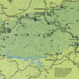
![[Map of Madison County, Va.].](https://cybercemetery.unt.edu/archive/oilspill/20121227225754im_/http://www.loc.gov/collections/static/hotchkiss-maps/images/cwh00046.jpg)
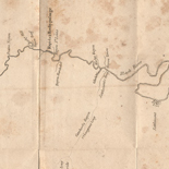
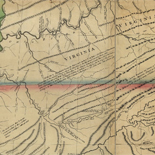
![Map of the Rappahannock River from [sic] Port Royal to Richards Ferry](https://cybercemetery.unt.edu/archive/oilspill/20121227225754im_/http://www.loc.gov/collections/static/civil-war-maps/images/cw0619600.jpg)
![[Coast of Maine from Frenchmans Bay to Mosquito Harbor].](https://cybercemetery.unt.edu/archive/oilspill/20121227225754im_/http://www.loc.gov/collections/static/american-revolutionary-war-maps/images/np000011.jpg)
![A correct map of a section of the United States showing the allignment [sic] of the Pittsburgh, Marion, and Chicago Railway between Chewton, Penna. and Marion, Ohio and connections.](https://cybercemetery.unt.edu/archive/oilspill/20121227225754im_/http://www.loc.gov/collections/static/railroad-maps-1828-to-1900/images/rr005350.jpg)
![[Topographical map of part of Washington D.C.].](https://cybercemetery.unt.edu/archive/oilspill/20121227225754im_/http://www.loc.gov/collections/static/civil-war-maps/images/cw0688500.jpg)

![[Map of Chancellorsville battlefield, May 3-4, 1863].](https://cybercemetery.unt.edu/archive/oilspill/20121227225754im_/http://www.loc.gov/collections/static/hotchkiss-maps/images/cwh00138.jpg)
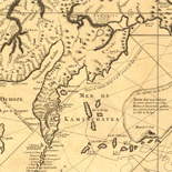
![Amérique septentrion.lle [i.e. septentrionale] : composée, corigée, et augmētée, sur les iournaux, mémoires, et observations les plus justes qui en ón'́etes.tes en l'année 1685 & 1686, par plusieurs particuliés](https://cybercemetery.unt.edu/archive/oilspill/20121227225754im_/http://www.loc.gov/collections/static/discovery-and-exploration/images/ct000667.jpg)
![[Map of cavalry engagement near Bridgewater, Va. Oct. 4th and 5th, 1864]](https://cybercemetery.unt.edu/archive/oilspill/20121227225754im_/http://www.loc.gov/collections/static/hotchkiss-maps/images/cwh00193.jpg)
Results
-

L'Afrique, ou Lybie ulterieure : ou font le Saara, or desért, le pays des Negres, la Guinee, et les pays circonv., tirée en partie de ...
Relief shown pictorially.
Contributor: Sanson, Nicolas Site: American Memory-cultural - Main Catalog Original Format: Map Date: 1679 View catalog record -

Africa.
Relief shown pictorially.
Contributor: Arnoldi, Arnoldo di Site: American Memory-cultural - Main Catalog Original Format: Map Date: 1600 View catalog record -

[A portolan chart of the Atlantic Ocean and adjacent Continents].
Also shows the southeast Pacific Ocean, the southwest Indian Ocean, as well as the continents of South America, Africa, Europe, and portions of North America and Asia.
Contributor: Roiz, Pascoal Site: American Memory-cultural - Main Catalog Original Format: Map Date: 1633 View catalog record -

A description of the sea coasts ... in the East Indies /
Covers the coasts of eastern Africa, India, and the East Indies.
Contributor: Hacke, William Site: American Memory-cultural - Main Catalog Original Format: Map Date: 1690 View catalog record -

Africae nova tabula /
Relief shown pictorially.
Contributor: Hondius, Jodocus Site: American Memory-cultural - Main Catalog Original Format: Map Date: 1640 View catalog record -

Totius Africæ accuratissima tabula /
Available also through the Library of Congress web site as a raster image.
Contributor: Wit, Frederik de Site: American Memory-cultural - Main Catalog Original Format: Map Date: 1688 View catalog record
Refine your search
Original Format
- Map
Online Format
- Image
Site
- American Memory-cultural
- Main Catalog