Map
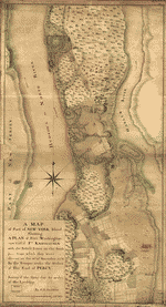
The City of New York as laid out by the Commissioners with the surrounding country /

| Format |
Map |
|---|---|
| Contributors |
Randel, John |
| Dates |
1821 |
| Location |
Manhattan New York Northeast Atlantic States Pennsylvania Philadelphia United States |
| Language |
English |
| Subjects |
Manhattan (New York) Manhattan (New York, N.Y.) New York (State) Northeast Atlantic States Pennsylvania Philadelphia Philadelphia (Pa.) United States |
- Title
- The City of New York as laid out by the Commissioners with the surrounding country /
- Description
-
Street planning map. Covers all of Manhattan Island (New York, N.Y.) and substantial parts of adjacent counties in New York and New Jersey. Shows existing and proposed streets; also buildings and other structures, streams and other wetlands, political boundaries.
-
Shows relief by hachures.
-
Available also through the Library of Congress Web site as a raster image.
-
Includes illustrations of surveying equipment used by the author.
-
Includes extensive text in left, right and lower margins outside neat line.
-
Includes 2 ancillary maps: Map of the States of Connecticut and Rh[ode Island] with p[arts of] New York, ...; The City of Philadelphia with the surrounding country by John Randel Junr.
-
Mounted on cloth and taped to brown binding. DLC
-
"Longitude East from London."
-
1 map : col. ; 19 x 33 cm., on sheet 70 X 100 cm.
- Creator
- Randel, John
- Created Published
-
New York : P. Maverik sculp., 1821.
- Subject Headings
-
-
Manhattan (New York, N.Y.)
-
-
Philadelphia (Pa.)
-
-
Northeast Atlantic States
-
-
United States--New York (State)--Manhattan (New York).
-
-
United States--Pennsylvania--Philadelphia.
-
-
United States--Northeast Atlantic States.
- Notes
-
-
Street planning map. Covers all of Manhattan Island (New York, N.Y.) and substantial parts of adjacent counties in New York and New Jersey. Shows existing and proposed streets; also buildings and other structures, streams and other wetlands, political boundaries.
-
-
Shows relief by hachures.
-
-
Available also through the Library of Congress Web site as a raster image.
-
-
Includes illustrations of surveying equipment used by the author.
-
-
Includes extensive text in left, right and lower margins outside neat line.
-
-
Includes 2 ancillary maps: Map of the States of Connecticut and Rh[ode Island] with p[arts of] New York, ...; The City of Philadelphia with the surrounding country by John Randel Junr.
-
-
Mounted on cloth and taped to brown binding. DLC
-
-
"Longitude East from London."
- Medium
-
1 map : col. ; 19 x 33 cm., on sheet 70 X 100 cm.
- Call Number
-
G3804.N4G45 1821 .R3
- Repository
-
Library of Congress Geography and Map Division Washington, D.C. 20540-4650 USA dcu
- Digital Id
-
g3804n ct001389 http://hdl.loc.gov/loc.gmd/g3804n.ct001389
- Library of Congress Catalog Number
- 2006629796
Rights & Access
The maps in the Map Collections materials were either published prior to 1922, produced by the United States government, or both (see catalogue records that accompany each map for information regarding date of publication and source). The Library of Congress is providing access to these materials for educational and research purposes and is not aware of any U.S. copyright protection (see Title 17 of the United States Code) or any other restrictions in the Map Collection materials.
Note that the written permission of the copyright owners and/or other rights holders (such as publicity and/or privacy rights) is required for distribution, reproduction, or other use of protected items beyond that allowed by fair use or other statutory exemptions. Responsibility for making an independent legal assessment of an item and securing any necessary permissions ultimately rests with persons desiring to use the item.
More about Copyright and other Restrictions
For guidance about compiling full citations consult Citing Primary Sources.
Part of...
-
Cities And Towns
[1965]
-
Geography And Maps Division
[60803]
-
American Memory
[1121009]
More maps like this
-
 [New York Island. Military. Unfinished.
Site:
American Memory-cultural, Main Catalog
Original Format:
Map
Date:
1778
View catalog record
[New York Island. Military. Unfinished.
Site:
American Memory-cultural, Main Catalog
Original Format:
Map
Date:
1778
View catalog record
-
 A tracing relating to Fort Washington or Knyphausen.
Contributor:
Sauthier, Claude Joseph
Site:
American Memory-cultural, Main Catalog
Original Format:
Map
Date:
1776
View catalog record
A tracing relating to Fort Washington or Knyphausen.
Contributor:
Sauthier, Claude Joseph
Site:
American Memory-cultural, Main Catalog
Original Format:
Map
Date:
1776
View catalog record
-
 [Unfinished draught for a topographical map of the northern part of New York Island.
Site:
American Memory-cultural, Main Catalog
Original Format:
Map
Date:
1778
View catalog record
[Unfinished draught for a topographical map of the northern part of New York Island.
Site:
American Memory-cultural, Main Catalog
Original Format:
Map
Date:
1778
View catalog record
-
 A map of part of New-York Island showing a plan of Fort Washington, now call'd Ft. Kniphausen with the rebels lines on the south part, ...
Contributor:
Sauthier, Claude Joseph
Site:
American Memory-cultural, Main Catalog
Original Format:
Map
Date:
1776
View catalog record
A map of part of New-York Island showing a plan of Fort Washington, now call'd Ft. Kniphausen with the rebels lines on the south part, ...
Contributor:
Sauthier, Claude Joseph
Site:
American Memory-cultural, Main Catalog
Original Format:
Map
Date:
1776
View catalog record
-
 [Bird's-eye-view of Manhattan and adjacent districts, New York City].
Site:
American Memory-cultural, Main Catalog
Original Format:
Map
Date:
1900
View catalog record
[Bird's-eye-view of Manhattan and adjacent districts, New York City].
Site:
American Memory-cultural, Main Catalog
Original Format:
Map
Date:
1900
View catalog record
-
 Topographical map of the City of New York : showing original water courses and made land /
Contributor:
Viele, Egbert L.
Site:
American Memory-cultural, Main Catalog
Original Format:
Map
Date:
1865
View catalog record
Topographical map of the City of New York : showing original water courses and made land /
Contributor:
Viele, Egbert L.
Site:
American Memory-cultural, Main Catalog
Original Format:
Map
Date:
1865
View catalog record
-
 The Tenement-House Committee maps /
Contributor:
Pierce, F. E.
Site:
American Memory-cultural, Main Catalog
Original Format:
Map
Date:
1894
View catalog record
The Tenement-House Committee maps /
Contributor:
Pierce, F. E.
Site:
American Memory-cultural, Main Catalog
Original Format:
Map
Date:
1894
View catalog record
-
 A topographical map of the northn. part of New York Island, exhibiting the plan of Fort Washington, now Fort Knyphausen, with the rebels lines to ...
Contributor:
Sauthier, Claude Joseph
Site:
American Memory-cultural, Main Catalog
Original Format:
Map
Date:
1777
View catalog record
A topographical map of the northn. part of New York Island, exhibiting the plan of Fort Washington, now Fort Knyphausen, with the rebels lines to ...
Contributor:
Sauthier, Claude Joseph
Site:
American Memory-cultural, Main Catalog
Original Format:
Map
Date:
1777
View catalog record
-
 [Map showing the Bowery Lane area of Manhattan.
Site:
American Memory-cultural, Main Catalog
Original Format:
Map
Date:
1760
View catalog record
[Map showing the Bowery Lane area of Manhattan.
Site:
American Memory-cultural, Main Catalog
Original Format:
Map
Date:
1760
View catalog record
-
 A topographical map of the northn. part of New York Island, exhibiting the plan of Fort Washington, now Fort Knyphausen, with the rebels lines to ...
Contributor:
Sauthier, Claude Joseph
Site:
American Memory-cultural, Main Catalog
Original Format:
Map
Date:
1777
View catalog record
A topographical map of the northn. part of New York Island, exhibiting the plan of Fort Washington, now Fort Knyphausen, with the rebels lines to ...
Contributor:
Sauthier, Claude Joseph
Site:
American Memory-cultural, Main Catalog
Original Format:
Map
Date:
1777
View catalog record
-
 The Merchants' Association hotel and theater map.
Contributor:
Merchants Association of New York
Site:
American Memory-cultural, Main Catalog
Original Format:
Map
Date:
1906
View catalog record
The Merchants' Association hotel and theater map.
Contributor:
Merchants Association of New York
Site:
American Memory-cultural, Main Catalog
Original Format:
Map
Date:
1906
View catalog record
-
 Map and guide of the elevated railroads of New York City.
Contributor:
Latimer, H. I.
Site:
American Memory-cultural, Main Catalog
Original Format:
Map
Date:
1881
View catalog record
Map and guide of the elevated railroads of New York City.
Contributor:
Latimer, H. I.
Site:
American Memory-cultural, Main Catalog
Original Format:
Map
Date:
1881
View catalog record
-
 Topographical map of the city and county of New-York, and the adjacent country : with views in the border of the principal buildings, and interesting ...
Contributor:
J.H. Colton & Co
Site:
American Memory-cultural, Main Catalog
Original Format:
Map
Date:
1836
View catalog record
Topographical map of the city and county of New-York, and the adjacent country : with views in the border of the principal buildings, and interesting ...
Contributor:
J.H. Colton & Co
Site:
American Memory-cultural, Main Catalog
Original Format:
Map
Date:
1836
View catalog record
-
 Nord de l'Ile de New-York.
Site:
American Memory-cultural, Main Catalog
Original Format:
Map
Date:
1781
View catalog record
Nord de l'Ile de New-York.
Site:
American Memory-cultural, Main Catalog
Original Format:
Map
Date:
1781
View catalog record
-
 This map of the city of New York and island of Manhattan, as laid out by the commissioners appointed by the legislature, April 3d, 1807 ...
Contributor:
Bridges, William
Site:
American Memory-cultural, Main Catalog
Original Format:
Map
Date:
1811
View catalog record
This map of the city of New York and island of Manhattan, as laid out by the commissioners appointed by the legislature, April 3d, 1807 ...
Contributor:
Bridges, William
Site:
American Memory-cultural, Main Catalog
Original Format:
Map
Date:
1811
View catalog record
-
 [New York Island. Military; unfinished.
Site:
American Memory-cultural, Main Catalog
Original Format:
Map
Date:
1776
View catalog record
[New York Island. Military; unfinished.
Site:
American Memory-cultural, Main Catalog
Original Format:
Map
Date:
1776
View catalog record
You might also like
-
 Stereoscopic views of prisons in New York City
Site:
American Memory-cultural
Original Format:
Photo, Print, Drawing
Date:
1865
Stereoscopic views of prisons in New York City
Site:
American Memory-cultural
Original Format:
Photo, Print, Drawing
Date:
1865
-

 New York und Philadelphia. Ein führer für alle diejenigen, welche die weltausstellung zu Philadelphia besuchen und auch New York berühren ...
Site:
Main Catalog
Original Format:
Book
Date:
1876
New York und Philadelphia. Ein führer für alle diejenigen, welche die weltausstellung zu Philadelphia besuchen und auch New York berühren ...
Site:
Main Catalog
Original Format:
Book
Date:
1876
-
 Night scene in Manhattan
Contributor:
Abbott, Berenice
Site:
Prints & Photographs, Main Catalog
Original Format:
Photo, Print, Drawing
Date:
1976
View catalog record
Night scene in Manhattan
Contributor:
Abbott, Berenice
Site:
Prints & Photographs, Main Catalog
Original Format:
Photo, Print, Drawing
Date:
1976
View catalog record
-
 Approaching storm, Manhattan
Contributor:
Landeck, Armin
Site:
Prints & Photographs, Main Catalog
Original Format:
Photo, Print, Drawing
Date:
1937
View catalog record
Approaching storm, Manhattan
Contributor:
Landeck, Armin
Site:
Prints & Photographs, Main Catalog
Original Format:
Photo, Print, Drawing
Date:
1937
View catalog record
-
 [Mid-town Manhattan, looking northeast toward Chrysler Building]
Contributor:
Frange, William
Site:
Prints & Photographs, Main Catalog
Original Format:
Photo, Print, Drawing
Date:
1931
View catalog record
[Mid-town Manhattan, looking northeast toward Chrysler Building]
Contributor:
Frange, William
Site:
Prints & Photographs, Main Catalog
Original Format:
Photo, Print, Drawing
Date:
1931
View catalog record
-
 Skyline from Brooklyn
Contributor:
Lozowick, Louis
Site:
Prints & Photographs, Main Catalog
Original Format:
Photo, Print, Drawing
Date:
1936
View catalog record
Skyline from Brooklyn
Contributor:
Lozowick, Louis
Site:
Prints & Photographs, Main Catalog
Original Format:
Photo, Print, Drawing
Date:
1936
View catalog record