Map
Battle of Monocacy.

| Format |
Map |
|---|---|
| Dates |
1864 |
| Location |
Frederick County Maryland United States |
| Language |
English |
| Subjects |
Battle Of Frederick County Maryland MD Monocacy Monocacy, Battle Of, MD United States |
- Title
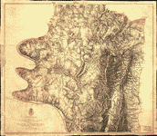
- Battle of Monocacy.
- Description
-
Shows Confederate troop movements and names of some residents.
-
Relief shown by hachures.
-
Pen-and-ink and pencil (some col.), mounted between sheets of transparent paper.
-
Date and scale from Stephenson's Civil War maps, 1989.
-
Map in pencil showing details of battle on verso.
-
LC Civil War maps (2nd ed.), H181
-
Available also through the Library of Congress web site as raster image.
-
In ink on red bordered label on verso: 286 crossed out.
-
1 ms. map : col. ; 17 x 12 cm.
- Created Published
-
[1864]
- Subject Headings
-
-
Monocacy, Battle of, Md., 1864
-
-
United States--Maryland--Frederick County.
-
-
Monocacy, Battle of, Md.
- Notes
-
-
Shows Confederate troop movements and names of some residents.
-
-
Relief shown by hachures.
-
-
Pen-and-ink and pencil (some col.), mounted between sheets of transparent paper.
-
-
Date and scale from Stephenson's Civil War maps, 1989.
-
-
Map in pencil showing details of battle on verso.
-
-
LC Civil War maps (2nd ed.), H181
-
-
Available also through the Library of Congress web site as raster image.
-
-
In ink on red bordered label on verso: 286 crossed out.
- Medium
-
1 ms. map : col. ; 17 x 12 cm.
- Call Number
-
G3842.M7S5 1864 .B3
- Repository
-
Library of Congress Geography and Map Division Washington, D.C. 20540-4650 dcu
- Digital Id
-
g3842m cwh00181 http://hdl.loc.gov/loc.gmd/g3842m.cwh00181
- Library of Congress Catalog Number
- 2005625088
Rights & Access
The maps in the Map Collections materials were either published prior to 1922, produced by the United States government, or both (see catalogue records that accompany each map for information regarding date of publication and source). The Library of Congress is providing access to these materials for educational and research purposes and is not aware of any U.S. copyright protection (see Title 17 of the United States Code) or any other restrictions in the Map Collection materials.
Note that the written permission of the copyright owners and/or other rights holders (such as publicity and/or privacy rights) is required for distribution, reproduction, or other use of protected items beyond that allowed by fair use or other statutory exemptions. Responsibility for making an independent legal assessment of an item and securing any necessary permissions ultimately rests with persons desiring to use the item.
More about Copyright and other Restrictions
For guidance about compiling full citations consult Citing Primary Sources.
Part of...
-
Hotchkiss Map Collection
[345]
-
Civil War Maps
[2281]
-
Military Battles And Campaigns Cartographic Items
[3867]
-
Geography And Maps Division
[60803]
-
American Memory
[1121009]
More maps like this
-
 Plan of the Battle of Monocacy, Maryland, July 9th, 1864.
Contributor:
Sneden, Robert Knox
Site:
American Memory-cultural
Original Format:
Map
Date:
1861
Plan of the Battle of Monocacy, Maryland, July 9th, 1864.
Contributor:
Sneden, Robert Knox
Site:
American Memory-cultural
Original Format:
Map
Date:
1861
-
 The Battle of South Mountain Md. showing positions at Fox's and Turner's Gaps, Sept. 14th 1862.
Contributor:
Sneden, Robert Knox
Site:
American Memory-cultural
Original Format:
Map
Date:
1861
The Battle of South Mountain Md. showing positions at Fox's and Turner's Gaps, Sept. 14th 1862.
Contributor:
Sneden, Robert Knox
Site:
American Memory-cultural
Original Format:
Map
Date:
1861
-
 The Battle of Crampton's Gap 5 miles south of Turner's Gap, South Mountain, Md. September 14th 1862.
Contributor:
Sneden, Robert Knox
Site:
American Memory-cultural
Original Format:
Map
Date:
1861
The Battle of Crampton's Gap 5 miles south of Turner's Gap, South Mountain, Md. September 14th 1862.
Contributor:
Sneden, Robert Knox
Site:
American Memory-cultural
Original Format:
Map
Date:
1861
-
 Battle of Crampton's Gap, Maryland : fought Septr 14th 1862.
Contributor:
Sneden, Robert Knox
Site:
American Memory-cultural
Original Format:
Map
Date:
1862
Battle of Crampton's Gap, Maryland : fought Septr 14th 1862.
Contributor:
Sneden, Robert Knox
Site:
American Memory-cultural
Original Format:
Map
Date:
1862
-
 Frederick County, Maryland /
Contributor:
Hergesheimer, E.
Site:
American Memory-cultural, Main Catalog
Original Format:
Map
Date:
1861
View catalog record
Frederick County, Maryland /
Contributor:
Hergesheimer, E.
Site:
American Memory-cultural, Main Catalog
Original Format:
Map
Date:
1861
View catalog record
-
 Map of Frederick County, Md. accurately drawn from correct instrumental surveys of all the county roads,
Contributor:
Bond, Isaac
Site:
American Memory-cultural, Main Catalog
Original Format:
Map
Date:
1858
View catalog record
Map of Frederick County, Md. accurately drawn from correct instrumental surveys of all the county roads,
Contributor:
Bond, Isaac
Site:
American Memory-cultural, Main Catalog
Original Format:
Map
Date:
1858
View catalog record
-
 Field note book of Wm. Luce, Eng. of Capt. J.W. Abert's party of U.S. Top. Engs., with pass from Gen. Banks of Oct. 1861 : ...
Contributor:
Luce, William
Site:
American Memory-cultural, Main Catalog
Original Format:
Map
Date:
1861
View catalog record
Field note book of Wm. Luce, Eng. of Capt. J.W. Abert's party of U.S. Top. Engs., with pass from Gen. Banks of Oct. 1861 : ...
Contributor:
Luce, William
Site:
American Memory-cultural, Main Catalog
Original Format:
Map
Date:
1861
View catalog record
-
 Part of Maryland : showing the positions of the armies at 6 a.m. September 16, 1862 /
Contributor:
Geo. W. Stadly & Co
Site:
American Memory-cultural
Original Format:
Map
Date:
1898-01-01
Part of Maryland : showing the positions of the armies at 6 a.m. September 16, 1862 /
Contributor:
Geo. W. Stadly & Co
Site:
American Memory-cultural
Original Format:
Map
Date:
1898-01-01
-
 The field of Sharpsburg or of the Antietam : showing the positions of the armies at 3 p.m. on September 17, 1862 /
Contributor:
Geo. W. Stadly & Co
Site:
American Memory-cultural
Original Format:
Map
Date:
1898-01-01
The field of Sharpsburg or of the Antietam : showing the positions of the armies at 3 p.m. on September 17, 1862 /
Contributor:
Geo. W. Stadly & Co
Site:
American Memory-cultural
Original Format:
Map
Date:
1898-01-01
-
 [Map of Loudoun County, Va., and parts of Fairfax County, Va., Jefferson County, W.Va., and Washington and Frederick counties, Md.].
Site:
American Memory-cultural, Main Catalog
Original Format:
Map
View catalog record
[Map of Loudoun County, Va., and parts of Fairfax County, Va., Jefferson County, W.Va., and Washington and Frederick counties, Md.].
Site:
American Memory-cultural, Main Catalog
Original Format:
Map
View catalog record
-
 Antietam Sharpsburg and vicinity. Constructed and engraved to illustrate "The war with the South"
Contributor:
Sholl, Charles
Site:
American Memory-cultural, Main Catalog
Original Format:
Map
Date:
1864
View catalog record
Antietam Sharpsburg and vicinity. Constructed and engraved to illustrate "The war with the South"
Contributor:
Sholl, Charles
Site:
American Memory-cultural, Main Catalog
Original Format:
Map
Date:
1864
View catalog record
-
 Antietam.
Contributor:
Michler, N.
Site:
American Memory-cultural, Main Catalog
Original Format:
Map
Date:
1867
View catalog record
Antietam.
Contributor:
Michler, N.
Site:
American Memory-cultural, Main Catalog
Original Format:
Map
Date:
1867
View catalog record
-
 Map of the battlefield of Antietam,
Contributor:
Willcox, William H.
Site:
American Memory-cultural, Main Catalog
Original Format:
Map
Date:
1862
View catalog record
Map of the battlefield of Antietam,
Contributor:
Willcox, William H.
Site:
American Memory-cultural, Main Catalog
Original Format:
Map
Date:
1862
View catalog record
-
 Map of the battlefield of Antietam
Contributor:
Antietam Battlefield Board
Site:
American Memory-cultural, Main Catalog
Original Format:
Map
Date:
1898
View catalog record
Map of the battlefield of Antietam
Contributor:
Antietam Battlefield Board
Site:
American Memory-cultural, Main Catalog
Original Format:
Map
Date:
1898
View catalog record
-
 Antietam. Enlarged and corrected from map of Gen. Michler, U.S. Eng.,
Contributor:
Gould, Oliver C.
Site:
American Memory-cultural, Main Catalog
Original Format:
Map
View catalog record
Antietam. Enlarged and corrected from map of Gen. Michler, U.S. Eng.,
Contributor:
Gould, Oliver C.
Site:
American Memory-cultural, Main Catalog
Original Format:
Map
View catalog record
You might also like
-
 Threshing wheat. Frederick County, Maryland
Contributor:
Rothstein, Arthur
Site:
Prints & Photographs
Original Format:
Photo, Print, Drawing
Date:
1937
Threshing wheat. Frederick County, Maryland
Contributor:
Rothstein, Arthur
Site:
Prints & Photographs
Original Format:
Photo, Print, Drawing
Date:
1937
-
 Emmitsburg, Maryland. Square
Contributor:
Delano, Jack
Site:
Prints & Photographs
Original Format:
Photo, Print, Drawing
Date:
1943
Emmitsburg, Maryland. Square
Contributor:
Delano, Jack
Site:
Prints & Photographs
Original Format:
Photo, Print, Drawing
Date:
1943
-
 Emmitsburg (vicinity), Maryland. Countryside
Contributor:
Collins, Marjory
Site:
Prints & Photographs
Original Format:
Photo, Print, Drawing
Date:
1943
Emmitsburg (vicinity), Maryland. Countryside
Contributor:
Collins, Marjory
Site:
Prints & Photographs
Original Format:
Photo, Print, Drawing
Date:
1943
-
 Emmitsburg, Maryland. Square
Contributor:
Collins, Marjory
Site:
Prints & Photographs
Original Format:
Photo, Print, Drawing
Date:
1943
Emmitsburg, Maryland. Square
Contributor:
Collins, Marjory
Site:
Prints & Photographs
Original Format:
Photo, Print, Drawing
Date:
1943
-
 Emmitsburg (vicinity), Maryland. A field after the snow has melted
Contributor:
Collins, Marjory
Site:
Prints & Photographs
Original Format:
Photo, Print, Drawing
Date:
1943
Emmitsburg (vicinity), Maryland. A field after the snow has melted
Contributor:
Collins, Marjory
Site:
Prints & Photographs
Original Format:
Photo, Print, Drawing
Date:
1943
-
 Emmitsburg, Maryland. Street scene
Contributor:
Collins, Marjory
Site:
Prints & Photographs
Original Format:
Photo, Print, Drawing
Date:
1943
Emmitsburg, Maryland. Street scene
Contributor:
Collins, Marjory
Site:
Prints & Photographs
Original Format:
Photo, Print, Drawing
Date:
1943